Kerala Plus One Answer Key 2025 Geography
Finished viewing? Save it for later —
Download Kerala Plus One Answer Key 2025 Geography (PDF · 8 pages)About Kerala Plus One Answer Key 2025 Geography
Kerala Plus One Answer Key 2025 Geography is available here for free download. Published by Kerala Board for Class 11, this answer key can be viewed online or downloaded as a PDF (8 pages). Candidates preparing for Class 11 can use Kerala Plus One Answer Key 2025 Geography to understand the exam pattern, the type of questions asked, and the overall difficulty level.
Frequently Asked Questions
How can I download Kerala Plus One Answer Key 2025 Geography?
Open this page and click the Download button to save Kerala Plus One Answer Key 2025 Geography as a PDF. It is completely free on AglaSem Docs.
Is Kerala Plus One Answer Key 2025 Geography free to download?
Yes. Kerala Plus One Answer Key 2025 Geography can be viewed online and downloaded as a PDF free of cost on AglaSem Docs.
How many pages does Kerala Plus One Answer Key 2025 Geography have?
Kerala Plus One Answer Key 2025 Geography contains 8 pages, which you can read online or download together as a single PDF.
Where can I find more Class 11 study material?
You can find more Class 11 question papers, sample papers, syllabus, and answer keys on AglaSem Docs.
Kerala Plus One Answer Key 2025 Geography – Text
Read the full text of this answer key below — useful to quickly search, copy and reference the content online without downloading the PDF.
📄 View text version (8 pages)
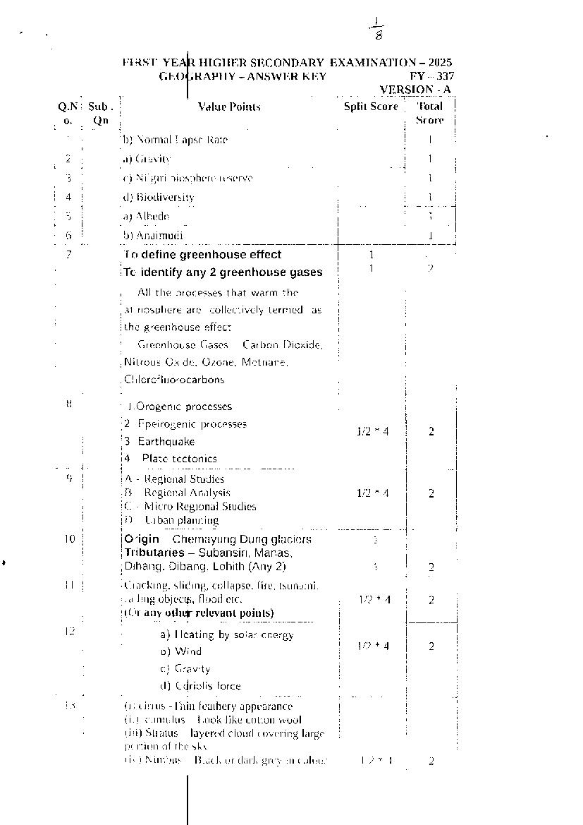
Page 1
FIR,ST IIIGIII]R SF',CONDARY EXAMINATION _ 2025
FY - 337
VERSION - A
Q.N Sub. Value Points Split Score Total
o. Qn Score
1 b; Normal T,apse lLate 1
2 a) (iravity 1
j
3 <-) Nilgiri biosphcrc rclscrvc 1
4 d) 13iodiversity l
5 a) Albedo 1
6 b) Anaimudi 1
-7
To define greenhouse effect I
Tc, identify any 2 greenhouse gases 1 2
All the processes that warm the
atrrosphere are collectively termed as
the greenhouse ef[ect.
Greenhouse Gases -- Carbon Dioxide,
Nitrous Oxide, Ozone, Methane,
C l'r lorof I uorocarbo n s
B l.Orogenic processes
2. Epeirogenic processes
U2* 4 2
3 Earthquake
4. Plate tectonics
j-
I
9 A - Ilegional Studies
I) llegional Arralysis 712* 4 2
C - Micro l{egional Studies
D lJrban planning
1 0 Origin - Chemayung Dung glaciers
Tributaries - Subansiri, Manas,
* I
Dihang, Dibang, Lohith (Any 2)
i
?
1
I
I (.racking, sliding, collapse, fire, tsunami,
!
fa ling objccp, flood t'.tc. 1t2+ 4 2
I 1C.tr any othef relevant points)
J----
i, a) Heating by solar energy
b) Wind 7t2* 4
c) Gravity
d) c{rior is force
l
r3 (i t cirrus -I'hin fcathcry appcarance
(ir) curnulus -l,ook like cotton wool
iiii) Stratus -- layerecl cloud covering large
p( rtioll of the sky,
(ir ) Nirttbus Illack or clark grc1, in colour 1t'2*4 , 2
Page 2
I4 * Carbon dioxide is meteorologically a
very important gas
* CO2 is transparent to the incoming
solar radiation but opaque to the lil 2
outgoing terrestrial radiation
* lt absorbs a part of terrestrial radiation
and reflects back some part of it towards
the earth's surface
* Carbon Dioxide is largely responsible
for the greenhouse efflect
(Any 2 points)
15 i) Analysis of properties of matter
ii) Meteors
112 * 'L 2
iii) Gravitation
iv) Magnetic field
v) Seismic activity
v) Earthquake
(Any 4 points)
16 l) -'lbpography
C - Climate 712* 4 2
D - Biological Activity
E - Time
(Arrange in any order)
t7 To identifv Trooical Deciduous forests t
* These are the most widespread forests
in lndia.
* They are also called the monsoon
2
forests
* found in monsoon rainfall areas-
annual rainfall between 70-200cm
* Types -
a) Moist deciduous forest
b) Dry deciduous forest
( Any 2 relevant points) 1
* Running water
18 - V shaped valley - Ox 1
bow lake
* Wind Mushroom rock - Barchan
- 1 2
19 1. Latitude /a r.r, cz ^I.|JFZ5A A Suve-
The Tropic of Cancer passes "t,
@lrO[+2
through the central part of lndia in east-
-[lrus, northern part of the
west direction
lndia lies in sub-tropical and temperate I
I
l
Page 3
I
I
l
I
zone and part lying south of thc
I
Tropic of C
l
I
cer falls in the tropical zone
!
I
2
;
I
The lofty Himalayas in the north
:
al,rng with its extensions act as an
e{:ective climatic divide. The towering
mcuntain chain provides an invincible 1+1+1
shreld to protect the subcontinent from
the cold northern winds
3 Distribution of l6nd and water
lndia is flanked by the lndian
Ocean on three sides it the south and
girdled by a high and continuous
mountain-wall in the north which make
difference in air pressure causes reversal
irr the direction of monsoon winds
4 Distance from the Sea
With a long coastline,large coastal
areas have an equable climate. Areas in
the interior of lndia are far away from the
n'oderating influence of the sea. Such
areas have extremes of climate.
5 Altitude
Temperature decreases with
h,:ight.Due to thin air, places in the
niountains are cooler than places on the
P:ai ns
6 Relief
The physiography or relief of lndia
arso affects the temperature, air pressure.
direction and speed of wind and the
amount and distribution of rainfall. The
i
I
u,indward sides of Western Ghats and
I
I Assam receive high rainfall
I
( Explain any 3 factors) 3
i
i20
1
l. Divergent Boundaries
i
!
ll. Convergent Boundaries
i
Il!. Transform Boundaries
I. Diyergent Boundaries or
( onstructive M?rgins
Page 4
8
* Area where two plates pull away from
each other
* As a result new crust is generated
The sites where the plates move away
from each other are called spreading
sites
* The best example - IVlid-Atlantic Ridge
lll. Convereerrt Boundaries
x Area where two plates moving towards
each other
* As a result, the crust is destroyed as
one plate dived under another
* The location where sinking of a plate
occurs is called a subductioir zone
ill Bou daries
* Area where plates slide horizontally
past each other
* Crust is neither prodrrced nor destroyed
* To identify plate boundaries 1 1t2
* To Explain each boundarY 1y'2 3
2r STRUCTURE OF THE EARTH
The Crust
* lt is the outermost solid part of the
earth
* lt is brittle in nature
* Oceanic crust is thinner as compared
to the continental crust
The Mantle
x The portion of the interior beyond the
Crdst
* The boundary separating Crtrst from
N/antle: Mohorovicic Discontinuity
t The mantle extends from lVoho's
discontinuity to a dePth of 2,900 km
* The upper Portion of the mantle is
called asthenosPhere
The Core
* lnner most laYer
* The core is made uP of verY heavY
material
Page 5
* Referrcd NIFE laycr (Nickel i lron)
( Answer 2 points in each layer )
To each layer
1U2 3
Tb explain each layer 7U2
22 1, Conduction
When two bodies of unequal
tc'mperature are in contact with one another,
tlrere is a flow of energy from the warmer to
crroler body.'I'his process is called 1+1+1 3
crlnduction
2. (lonvcction
I
I
I'he process of vertical heating of
:
l
i aunosphere is knoun as Convection.
I 3 Advection
I he processes of the transfc.r of lieat
j
tlirough horizontal movemenr ol air is called
L
arlvection
I 23 a) A - Stalactite
I 1
B - Piller 1
b)
! Underground water 1
24
i
Andaman and Nicobar island
I
x Andaman and Nicobar island
I
located in
Bay of Bengal
* They are volcanic origin
:* The Barren lsland is the only active
volcano in lndia (Nicobar lsland)
* There are approximately 572
islands
* Capital - Port Blair
* The Andaman in the north and
the
Nicobar in the south are separated by a
water body which is called the Ten
degree channel
* N/ountain Peak: Saddle peak
x To identify island group
i
To wlile 2 relevant poi nts
] llv 1+1 3
25 Stage I
i ln the beginning, all matter forming the
, Lrnivcrse existr,'cl in one lllacc in the orrl of
f
, "tinv t;all" (singular atonr) with an l+ 11 1 3
unimaginahrly srnall volumc, inf irrirc
tcmperature and infinitc densitv
litage 2
Ar the tSig llang the "tin-y ball" exploded
,. iolently
and led to huge expansion which
t rok placo 1.1.7 bill ion years llcfore the
Page 6
prescnl.
Stage 3
Within 300,000 years from the l3ig Bang,
temperature dropped to 4,500 K (Kelvitt)
and gave rise to atomic matter
26 a Guyots 1
b Atoll 1
C Thermocline 1 3
27 * To identify The Northern 1
Plains
* To explain the subdivision 3 4
l._BhaLar
* Narrow belt ranging between B-
1"0 km
* Parallel to the Shiwalik foothills
* The streams and rivers coming
from the mountains dePosit heavY
materials of rocks and boulders
* Rivers disappear in this zone
2. Terai
* South of the Bhabar is the Tarai
belt
* width of 10-20 km
* where streams and rivers re-
emerge without having anY
properly demarcated channel
creating marshy and swamPY
conditions
* Luxurious growth of natural
vegetation and houses a varied
wild life
3. Alluvial plain
* The south of Tarai is a belt consisting
of Alluvial Plains- Bhangar and Khadar
* Bhangar: The old alluvial dePosit
* Khadar: The new alluvial dePosit
Known for Sunderban Delta, the largest
delta in the world
28 a GEOSTROPHIC WIND - ThC WiNd
blows parallel to isobar is known as 1
Geostrophic Wind.
b FRONT- The separating zone between 4
warm and cold air masses is called 1
Front
C WATER SPROUT - Tornado over the 1
sea is called water sProut
d SEA BREEZE - During the daY the land 1
heats up faster and become warmer
than the sea. Thus ,pressure gradient
from sea to land is created and the wind
blows from sea to land
Page 7
a
5
29 1. Spring tides
* Spr,ng Tides re formed when the sun,
2
the rroon and the earth are in a straight
line
* The: height of the tide will be higher 4
* The:y occur twice a month, one on frrll
moori period and another during new
moon period.
Z_\!_eap tides
x When the sun and moon are at right
angles to each other and the forces of
the s-rn and moon tend to counteract
one i noth€r, the neap tides are formed
x l-here is a seven day interval between 2
the spring tides and neap tides
x '[he height of the tides are
comparatively low
30 *'Ib identify Alfred Wegner
1 Tlre Matching oLCoqtinents (Jiq.
Saw-fil)
* -fhe shorelines of Africa and South
America facing each other have a
remarkable and unmistakable match.
4
* A map produced using a computer
programme by Bullard in 1964 shows the
Atlantic margins are perfectly matched.
2. Rocks of Same Age across the
Qgeatts
x The radiometric dating methods
developed in the recent period shows
that the belt of ancient rocks of 2,000
million years from Brazil coast matches
with those from western Africa.
* lt is formed during Jurassic Age.
x Tlris suggests that the ocean did not
exist prior to that time
3._J iltite
x Tillite is sedimentary rock formed out
lof deposits of glaciers.
I
lt T re Gondawana systems of sediments
l, _-.__ L___ _ ,.i
Page 8
*
t-
are found in lndia have a remarkable
match with the sediments from Africa,
Falkland lsland, N/adagascar, Antarctica
and Australia.
4. Placer Deposits
* The placer deposits of Ghana are
derived from the gold bearing veins in
Brazil plateau when the two countries lay
side by side
5. Distribution of Fossils
* Lemur is found in lndia, Africa and
lVladagascar
* The only two places where lVesosattrtts
fossils have beetr fottnd "16 far are the
lraver Rock Formation in Brazil and the
Southern Cape Province of South Africa.
* All these indicate that all these
landmasses once lay together. 3
* To Explain any 3 evidences
31 a Focus or Hypocenter:- The point where 1
the energy is released
Epicenter:- The point on the surface, 1
nearest to the focus (lt is the first one to
experience the waves)
Tvpes of Earthquakes
b 1. Tectonic Earthquake
2. Volcanic Earthquake
3. Collapse Earthquake
4. Explosion Earthquake
5. Reservoir lnduced Earl:hqtrake
2 4
(Ary 4 types)
32 a Palk Strait 1
b Tropic Of Cancer 1 4
c Western Ghats 1
d Luni 1
r,F,^J[.S-J la,a_s
@_
2, Aon,f ,A4 -@ ; c'Y')
3^ l(qrrn4r)V L
4. *retr. \,e<_
..-,
Document Details
| Board / Org | Kerala Board |
| Exam | Class 11 |
| Type | Answer Key |
| Pages | 8 |
| Updated | 24 Sep 2026 |