DUET 2021 Question Paper M.Sc Geology
Finished viewing? Save it for later —
Download DUET 2021 Question Paper M.Sc Geology (PDF · 14 pages)About DUET 2021 Question Paper M.Sc Geology
DUET 2021 Question Paper M.Sc Geology is available here for free download. Published by NTA for DUET, this question paper can be viewed online or downloaded as a PDF (14 pages). Candidates preparing for DUET can use DUET 2021 Question Paper M.Sc Geology to understand the exam pattern, the type of questions asked, and the overall difficulty level.
Frequently Asked Questions
How can I download DUET 2021 Question Paper M.Sc Geology?
Open this page and click the Download button to save DUET 2021 Question Paper M.Sc Geology as a PDF. It is completely free on AglaSem Docs.
Is DUET 2021 Question Paper M.Sc Geology free to download?
Yes. DUET 2021 Question Paper M.Sc Geology can be viewed online and downloaded as a PDF free of cost on AglaSem Docs.
How many pages does DUET 2021 Question Paper M.Sc Geology have?
DUET 2021 Question Paper M.Sc Geology contains 14 pages, which you can read online or download together as a single PDF.
Where can I find more DUET study material?
You can find more DUET question papers, sample papers, syllabus, and answer keys on AglaSem Docs.
DUET 2021 Question Paper M.Sc Geology – Text
Read the full text of this question paper below — useful to quickly search, copy and reference the content online without downloading the PDF.
📄 View text version (14 pages)
Page 1
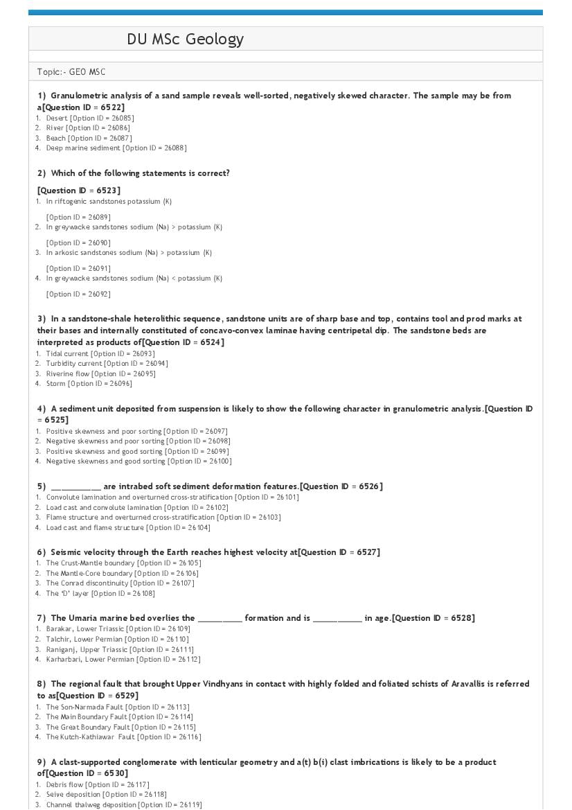
Topic:‐ GEO MSC
1) Granulometric analysis of a sand sample reveals well‐sorted, negatively skewed character. The sample may be from
a[Question ID = 6522]
1. Desert [Option ID = 26085]
2. River [Option ID = 26086]
3. Beach [Option ID = 26087]
4. Deep marine sediment [Option ID = 26088]
2) Which of the following statements is correct?
[Question ID = 6523]
1. In riftogenic sandstones potassium (K)
[Option ID = 26089]
2. In greywacke sandstones sodium (Na) > potassium (K)
[Option ID = 26090]
3. In arkosic sandstones sodium (Na) > potassium (K)
[Option ID = 26091]
4. In greywacke sandstones sodium (Na) < potassium (K)
[Option ID = 26092]
3) In a sandstone‐shale heterolithic sequence, sandstone units are of sharp base and top, contains tool and prod marks at
their bases and internally constituted of concavo‐convex laminae having centripetal dip. The sandstone beds are
interpreted as products of[Question ID = 6524]
1. Tidal current [Option ID = 26093]
2. Turbidity current [Option ID = 26094]
3. Riverine flow [Option ID = 26095]
4. Storm [Option ID = 26096]
4) A sediment unit deposited from suspension is likely to show the following character in granulometric analysis.[Question ID
= 6525]
1. Positive skewness and poor sorting [Option ID = 26097]
2. Negative skewness and poor sorting [Option ID = 26098]
3. Positive skewness and good sorting [Option ID = 26099]
4. Negative skewness and good sorting [Option ID = 26100]
5) __________ are intrabed soft sediment deformation features.[Question ID = 6526]
1. Convolute lamination and overturned cross‐stratification [Option ID = 26101]
2. Load cast and convolute lamination [Option ID = 26102]
3. Flame structure and overturned cross‐stratification [Option ID = 26103]
4. Load cast and flame structure [Option ID = 26104]
6) Seismic velocity through the Earth reaches highest velocity at[Question ID = 6527]
1. The Crust‐Mantle boundary [Option ID = 26105]
2. The Mantle‐Core boundary [Option ID = 26106]
3. The Conrad discontinuity [Option ID = 26107]
4. The ‘D’ layer [Option ID = 26108]
7) The Umaria marine bed overlies the _________ formation and is __________ in age.[Question ID = 6528]
1. Barakar, Lower Triassic [Option ID = 26109]
2. Talchir, Lower Permian [Option ID = 26110]
3. Raniganj, Upper Triassic [Option ID = 26111]
4. Karharbari, Lower Permian [Option ID = 26112]
8) The regional fault that brought Upper Vindhyans in contact with highly folded and foliated schists of Aravallis is referred
to as[Question ID = 6529]
1. The Son‐Narmada Fault [Option ID = 26113]
2. The Main Boundary Fault [Option ID = 26114]
3. The Great Boundary Fault [Option ID = 26115]
4. The Kutch‐Kathiawar Fault [Option ID = 26116]
9) A clast‐supported conglomerate with lenticular geometry and a(t) b(i) clast imbrications is likely to be a product
of[Question ID = 6530]
1. Debris flow [Option ID = 26117]
2. Seive deposition [Option ID = 26118]
3. Channel thalweg deposition [Option ID = 26119]
Page 2
10) If ‘P’ represents the seismic P‐wave, ‘S’ represents the seismic Shear wave and ‘L’ represents the seismic Love wave,
then disaster sequence of seismic waves will be
[Question ID = 6531]
1. P>S>L
[Option ID = 26121]
2. L>P>S
[Option ID = 26122]
3. P>L>S
[Option ID = 26123]
4. P
[Option ID = 26124]
11) Coral reefs are generally found in the latitudinal extensions[Question ID = 6532]
1. 200 N – 200 S [Option ID = 26125]
2. 300N – 300 S [Option ID = 26126]
3. 450 N – 450S [Option ID = 26127]
4. 600N – 600S [Option ID = 26128]
12) Which of the following is a fundamental lithostratigraphic unit?[Question ID = 6533]
1. Supergroup [Option ID = 26129]
2. Group [Option ID = 26130]
3. Formation [Option ID = 26131]
4. Member [Option ID = 26132]
13) A grain is settling through a column of water. If the radius of the grain ‘R’ is smaller than 0.1mm, the relationship
between grain settling velocity ( V) and grain radius (R) will be[Question ID = 6534]
1. V = √R [Option ID = 26133]
2. V = R2 [Option ID = 26134]
3. log V = 2 log R + C [Option ID = 26135]
4. log V = ½ log R +C [Option ID = 26136]
14) Petromict conglomerates are[Question ID = 6535]
1. Conglomerates with Single type of clasts [Option ID = 26137]
2. Conglomerates with a mixture of largely unstable and metastable clasts including basalt, lst., shale, phyllite etc. [Option ID = 26138]
3. Conglomerates with a mixture of largely stable clasts including quartzite, vein quartz etc. [Option ID = 26139]
4. Unconformity‐related [Option ID = 26140]
15) Sandy coastline with an extensive area of beach directly adjacent to the coastal plain is termed as
[Question ID = 6536]
1. Shoreface
[Option ID = 26141]
2. Chenier
[Option ID = 26142]
3. Foreshore
[Option ID = 26143]
4. Strand plain
[Option ID = 26144]
16) A unfossiliferous sandstone succession overlies ¬1870 Ma old granite basement. A diabase dyke of 750 Ma age cuts
across the granite and abuts against the granite‐sandstone contact. A geologist would[Question ID = 6537]
1. Interpret the age of sandstone older than 1870 Ma [Option ID = 26145]
2. Interpret the age of sandstone older than 750 Ma but younger than 1870 Ma [Option ID = 26146]
3. Interpret the age of sandstone younger than 750 Ma [Option ID = 26147]
4. Not attempt any interpretation regarding age of the sandstone [Option ID = 26148]
17) Match List I with List II
List I List II
A. Current Crescent I. Intrabed Structure
B. Convolute lamination II. Interbed Structure
C. Flute Mark III. Bedding Plane Structure
D. Load Mark IV. Sole Structure
Choose the correct answer from the options given below:
[Question ID = 6538]
1. A ‐ II, B ‐I , C ‐IV , D ‐ III [Option ID = 26149]
2. A ‐ I, B ‐ II, C ‐ IV , D ‐ III [Option ID = 26150]
Page 3
4. A ‐ III , B ‐ II , C ‐ I , D ‐ IV [Option ID = 26152]
18) The time‐rock unit ‘stage’ corresponds with ______ of the time unit.[Question ID = 6539]
1. Epoch [Option ID = 26153]
2. Age [Option ID = 26154]
3. Chron [Option ID = 26155]
4. Era [Option ID = 26156]
19) In terms of decreasing flow energy, arrange the following
A. flute mark
B. planar‐tabular cross‐stratification
C. parting lineation
D. planar‐curved cross‐stratification
[Question ID = 6540]
1. A, B, C, D
[Option ID = 26157]
2. A, C, B, D
[Option ID = 26158]
3. D, C, B, A
[Option ID = 26159]
4. A, D, C, B
[Option ID = 26160]
20) Palghat‐Cauvery shear zone[Question ID = 6541]
1. Demarcates the boundary between the eastern and western Dharwar craton [Option ID = 26161]
2. Dissects the southern granulite terrane [Option ID = 26162]
3. Marks the boundary of Eastern Ghat Mobile Belt [Option ID = 26163]
4. Is an extension of Singbhum shear zone [Option ID = 26164]
21) The correct sequence in terms of decreasing geologic age is:[Question ID = 6542]
1. Dalma trap > Bijli rhyolites > Sitagota volcanics > Malani volcanics [Option ID = 26165]
2. Sitagota volcanics > Bijli rhyolites > Dalma trap > Malani volcanics [Option ID = 26166]
3. Dalma trap > Sitagota volcanics > Bijli rhyolite > Malani volcanics [Option ID = 26167]
4. Bijli rhyolite > Dalma trap > Malani volcanics > Sitagota volcanics [Option ID = 26168]
22) One can expect precipitation of __________ as dominant carbonate mineralogy from saturated sea water when
CO2 pressure in atmosphere becomes high.[Question ID = 6543]
1. Low‐Mg calcite and aragonite [Option ID = 26169]
2. High‐Mg calcite [Option ID = 26170]
3. High‐Mg calcite and aragonite [Option ID = 26171]
4. High‐Mg calcite and dolomite [Option ID = 26172]
23) A poorly‐sorted trough cross‐stratified granular sandstone with occasional interbeds of lenticular conglomerate having
sub‐rounded to rounded clasts is likely to be interpreted as a product of[Question ID = 6544]
1. Beach environment [Option ID = 26173]
2. Eolian environment [Option ID = 26174]
3. Alluvial environment [Option ID = 26175]
4. Tidal environment [Option ID = 26176]
24) Meniscus and Pendant cement are products of[Question ID = 6545]
1. Deep burial diagenesis [Option ID = 26177]
2. Sea floor diagenesis [Option ID = 26178]
3. Vadose diagenesis [Option ID = 26179]
4. Phreatic diagenesis [Option ID = 26180]
25) Syn‐sedimentary deformation structures may be a result of[Question ID = 6546]
1. Low sedimentation [Option ID = 26181]
2. High sedimentation [Option ID = 26182]
3. Marine transgression [Option ID = 26183]
4. Marine regression [Option ID = 26184]
26) By the term ‘Boundary layer’ in a fluid flow, we refer to[Question ID = 6547]
1. A portion of a flow within which a velocity gradient develops due to friction within the bed [Option ID = 26185]
2. The boundary of a flow [Option ID = 26186]
3. The layers which bound a flow, may be air or solid surface [Option ID = 26187]
4. A portion of a flow within which velocity increases downward towards the underlying bed [Option ID = 26188]
Page 4
6548]
1. μ x ρ [Option ID = 26189]
2. μ2 x ρ [Option ID = 26190]
3. μ ‐ ρ [Option ID = 26191]
4. μ /ρ [Option ID = 26192]
28) The following mineral is a potassium and iron‐rich phyllosilicate[Question ID = 6549]
1. Muscovite [Option ID = 26193]
2. Biotite [Option ID = 26194]
3. Glauconite [Option ID = 26195]
4. Kaolinite [Option ID = 26196]
29) Aquifer anisotropy relates to[Question ID = 6550]
1. Temporal variation in aquifer parameters [Option ID = 26197]
2. Both spatial and temporal variation in aquifer parameters [Option ID = 26198]
3. Directional variation in aquifer parameters [Option ID = 26199]
4. Spatial variation in aquifer parameters [Option ID = 26200]
30) If the pole of a planar structure plots at the center of the Schmidt stereonet, the plane is[Question ID = 6551]
1. Vertical [Option ID = 26201]
2. Horizontal [Option ID = 26202]
3. Shallow dipping [Option ID = 26203]
4. Steep dipping [Option ID = 26204]
31) In one limb of a map‐scale fold, the cleavage (axial planar) dips at a shallower angle than the bedding. The fold is:
[Question ID = 6552]
1. An upright fold [Option ID = 26205]
2. A recumbent fold [Option ID = 26206]
3. An overturned fold [Option ID = 26207]
4. A cylindrical fold [Option ID = 26208]
32) Theim’s equation for steady state radial flow to a tubewell in confined aquifer can be used to estimate[Question ID =
6553]
1. Transmissivity only [Option ID = 26209]
2. Storativity only [Option ID = 26210]
3. Specific yield only [Option ID = 26211]
4. Both Transmissivity and Storativity [Option ID = 26212]
33) Grouting has proved effective in[Question ID = 6554]
1. Pumping Test [Option ID = 26213]
2. Aquifer Performance Test [Option ID = 26214]
3. Reducing percolation of water through dam foundations [Option ID = 26215]
4. Well Performance Test [Option ID = 26216]
34) The axial plane of a fold strikes N‐S and dips 150 easterly. The fold axis plunges about 150 towards N890E. The fold can
be classified as[Question ID = 6555]
1. An upright fold [Option ID = 26217]
2. A neutral fold [Option ID = 26218]
3. A recumbent fold [Option ID = 26219]
4. A reclined fold [Option ID = 26220]
35) Hydraulic conductivity is[Question ID = 6556]
1. Specific capacity [Option ID = 26221]
2. Transmissivity divided by the saturated aquifer thickness [Option ID = 26222]
3. Storativity multiplied by the aquifer thickness [Option ID = 26223]
4. Extension of the aquifer [Option ID = 26224]
36) An unconformity separating the younger sedimentary rock from the underlying older plutonic igneous rocks, is known
as[Question ID = 6557]
1. Para‐conformity [Option ID = 26225]
2. Angular unconformity [Option ID = 26226]
3. Non‐conformity [Option ID = 26227]
4. Disconformity [Option ID = 26228]
37) Measures to control rockfall include[Question ID = 6558]
1. Trenches [Option ID = 26229]
2. Wire mesh and rock traps [Option ID = 26230]
3. Check dams [Option ID = 26231]
4. Contour farming [Option ID = 26232]
38) Slickenside striations on a fault plane have a pitch of 250. The fault is[Question ID = 6559]
1. A strike‐slip fault [Option ID = 26233]
Page 5
3. An oblique‐slip fault [Option ID = 26235]
4. A transform fault [Option ID = 26236]
39) The major ions considered for hydrochemical facies analysis using trilinear plot are[Question ID = 6560]
1. Sodium, Potassium, Phosphorus, Magnesium, Chloride, Sulphate, Carbonate and Nitrate [Option ID = 26237]
2. Sodium, Potassium, Calcium, Magnesium, Chloride, Sulphate, Carbonate and Bicarbonate [Option ID = 26238]
3. Arsenic, Potassium, Calcium, Lead, Fluoride, Sulphate, Carbonate and Bicarbonate [Option ID = 26239]
4. Zinc, Mercury, Calcium, Magnesium, Aluminium , Sulphate, Carbonate and Bicarbonate [Option ID = 26240]
40) ‘Klippe’ and ‘Tectonic Window’ are terms related to[Question ID = 6561]
1. Plate subduction zone [Option ID = 26241]
2. Overthrust sheets [Option ID = 26242]
3. Diapiric intrusions [Option ID = 26243]
4. Salt domes [Option ID = 26244]
41) Total Dissolved Solids in the groundwater can also be estimated by measuring:
A. Electrical conductivity
B. Hydraulic conductivity
[Question ID = 6562]
1. A alone
[Option ID = 26245]
2. B alone
[Option ID = 26246]
3. Both A and B
[Option ID = 26247]
4. Neither A nor B
[Option ID = 26248]
42) The primary support for a tunnel in rock masses excavated by drilling and blasting may be provided by:
A. rock bolts, shotcrete or steel arches
B. contour ploughing
[Question ID = 6563]
1. A alone
[Option ID = 26249]
2. B alone
[Option ID = 26250]
3. Both A and B
[Option ID = 26251]
4. Neither A nor B
[Option ID = 26252]
43) Hydraulic conductivity is a function of:
A. Medium
B. Fluid
[Question ID = 6564]
1. A alone
[Option ID = 26253]
2. B alone
[Option ID = 26254]
3. Both A and B
[Option ID = 26255]
4. Neither A nor B
[Option ID = 26256]
44) Darcy’s law applies to :
A. Laminar flow in a saturated porous media
B. Turbulent flow
[Question ID = 6565]
1. A alone
[Option ID = 26257]
Page 6
[Option ID = 26258]
3. Both A and B
[Option ID = 26259]
4. Neither A nor B
[Option ID = 26260]
45) Given below are two statements, one is labelled as Assertion A and the other is labelled as Reason R
Assertion A: Porosity of a formation is approximately equal to sum of Specific retention and Specific yield.
Reason R: The sum of Specific retention and Specific yield gives a ratio of the volume of total interconnected voids to the
total volume of the rock or formation.
In light of the above statements, choose the most appropriate answer from the options given below
[Question ID = 6566]
1. Both A and R are correct and R is the correct explanation of A
[Option ID = 26261]
2. Both A and R are correct but R is NOT the correct explanation of A
[Option ID = 26262]
3. A is correct but R is not correct
[Option ID = 26263]
4. A is not correct but R is correct
[Option ID = 26264]
46) Given below are two statements, one is labelled as Assertion A and the other is labelled as Reason R
Assertion A: The high hydraulic gradient in earth dams accelerates erosive action where sediments are removed by seepage
forces, hence forming subsurface cavities and tunnels.
Reason R: Such subsurface cavities and tunnels in an earth dam is generally observed in loose material with less cohesion.
In light of the above statements, choose the most appropriate answer from the options given below
[Question ID = 6567]
1. Both A and R are correct and R is the correct explanation of A
[Option ID = 26265]
2. Both A and R are correct but R is NOT the correct explanation of A
[Option ID = 26266]
3. A is correct but R is not correct
[Option ID = 26267]
4. A is not correct but R is correct
[Option ID = 26268]
47) Given below are two statements, one is labelled as Assertion A and the other is labelled as Reason R
Assertion A: The compressive strength of a sandstone is not influenced by its porosity.
Reason R: The porosity of a rock can be defined as the percentage pore space within a given volume.
In light of the above statements, choose the most appropriate answer from the options given below
[Question ID = 6568]
1. Both A and R are correct and R is the correct explanation of A
[Option ID = 26269]
2. Both A and R are correct but R is NOT the correct explanation of A
[Option ID = 26270]
3. A is correct but R is not correct
[Option ID = 26271]
4. A is not correct but R is correct
[Option ID = 26272]
48) Given below are two statements, one is labelled as Assertion A and the other is labelled as Reason R
Assertion A: During resistivity sounding in groundwater exploration, the electrode spacing is gradually increased.
Reason R: With the increase in electrode spacing, the deeper penetration of the electric field occurs, which helps in
assessing the vertical variation of the resistivity.
In light of the above statements, choose the most appropriate answer from the options given below
[Question ID = 6569]
Page 7
[Option ID = 26273]
2. Both A and R are correct but R is NOT the correct explanation of A
[Option ID = 26274]
3. A is correct but R is not correct
[Option ID = 26275]
4. A is not correct but R is correct
[Option ID = 26276]
49) Given below are two statements, one is labelled as Assertion A and the other is labelled as Reason R
Assertion A: Landslides generally refer to the rapid downward and outward movement of slope‐forming materials by falling,
sliding or flowing, or by some combination of these factors.
Reason R: The reason for landslide is that the forces creating movement, the disturbing forces exceed those resisting them,
the resisting forces.
In light of the above statements, choose the most appropriate answer from the options given below
[Question ID = 6570]
1. Both A and R are correct and R is the correct explanation of A
[Option ID = 26277]
2. Both A and R are correct but R is NOT the correct explanation of A
[Option ID = 26278]
3. A is correct but R is not correct
[Option ID = 26279]
4. A is not correct but R is correct
[Option ID = 26280]
50) Given below are two statements, one is labelled as Assertion A and the other is labelled as Reason R
Assertion A: Suitability of groundwater for irrigation uses is commonly studied by measuring Sodium Adsorption Ratio.
Reason R: Sodium reacts with soil to reduce its permeability.
In light of the above statements, choose the most appropriate answer from the options given below
[Question ID = 6571]
1. Both A and R are correct and R is the correct explanation of A
[Option ID = 26281]
2. Both A and R are correct but R is NOT the correct explanation of A
[Option ID = 26282]
3. A is correct but R is not correct
[Option ID = 26283]
4. A is not correct but R is correct
[Option ID = 26284]
51) Match List I with List II
List I List II
Aquifer Parameters Units
A. Hydraulic conductivity I. m3/day
B. Transmissivity II. m‐1
C. Specific storage III. m/day
D. Discharge IV. m2/day
Choose the correct answer from the options given below:
[Question ID = 6572]
1. A‐I, B‐III, C‐II, D‐IV
[Option ID = 26285]
2. A‐III, B‐IV, C‐II, D‐I
[Option ID = 26286]
3. A‐II, B‐IV, C‐II, D‐I
[Option ID = 26287]
4. A‐III, B‐IV, C‐I, D‐II
[Option ID = 26288]
Page 8
List I List II
Types of structures Types of structure/their process of construction
A. Shaft I. Driven either vertically or at steep angle upwards
B. Raise II. Driven vertically downwards
C. Concrete dam III. Rockfill dams
D. Earth dam IV. Arch dams
Choose the correct answer from the options given below:
[Question ID = 6573]
1. A‐II, B‐I, C‐IV, D‐III [Option ID = 26289]
2. A‐II, B‐IV, C‐III, D‐I [Option ID = 26290]
3. A‐II, B‐I, C‐III, D‐IV [Option ID = 26291]
4. A‐III, B‐IV, C‐I, D‐II [Option ID = 26292]
53) Match List I with List II
List I List II
Structures/spatial orientation/processes Structures/spatial orientation/rocks/process linked
environment
A. Foliation I. Cleavage
B. Mylonitization II. Plunge
C. Trend III. Fault rock
D. Gouge and breccia IV. High strain environment
Choose the correct answer from the options given below:
[Question ID = 6574]
1. A‐I, B‐II, C‐III, D‐IV [Option ID = 26293]
2. A‐II, B‐IV, C‐III, D‐I [Option ID = 26294]
3. A‐III, B‐II, C‐I, D‐IV [Option ID = 26295]
4. A‐I, B‐IV, C‐II, D‐III [Option ID = 26296]
54) Spaced cleavage is typically associated with:
A. An array of parallel to anastomosing, irregular to smooth, fracture‐like partings that typically are occupied by clayey and
carbonaceous matter.
B. Very fine‐grained (0.5 mm) pelitic (shaley) rocks metamorphosed to low grade.
[Question ID = 6575]
1. A alone
[Option ID = 26297]
2. B alone
[Option ID = 26298]
3. Both A and B
[Option ID = 26299]
4. Neither A nor B
[Option ID = 26300]
55) Z‐ shaped kink folds are called as :
A. Dextral Kinks
B. Sinistral Kinks
[Question ID = 6576]
1. A alone
[Option ID = 26301]
2. B alone
[Option ID = 26302]
3. Both A and B
[Option ID = 26303]
4. Neither A nor B
[Option ID = 26304]
56) Strike slip faults are caused due to the horizontal slip between the adjacent blocks. Depending on the sense of actual
relative movement they can be described as:
A. Reverse or thrust
B. Left handed or right handed
Page 9
1. A alone
[Option ID = 26305]
2. B alone
[Option ID = 26306]
3. Both A and B
[Option ID = 26307]
4. Neither A nor B
[Option ID = 26308]
57) In general the rate of soil production _____________________ with increase in depth of soil.[Question ID = 6578]
1. increases [Option ID = 26309]
2. decreases [Option ID = 26310]
3. remains constant [Option ID = 26311]
4. may increase or decrease [Option ID = 26312]
58) __________________ dating relies on releasing energy stored in mineral crystal lattices.[Question ID = 6579]
1. Radio Carbon [Option ID = 26313]
2. U/Th [Option ID = 26314]
3. Tree ring [Option ID = 26315]
4. Luminescence [Option ID = 26316]
59) Match List I with List II
List I List II
Landforms Process
A. Kame I. Aeolian
B. Chute II. Glacial
C. Ventifact III. Fluvial
Choose the correct answer from the options given below:
[Question ID = 6580]
1. A ‐ I, B ‐ II, C ‐ III [Option ID = 26317]
2. A ‐ II, B ‐ III, C ‐ I [Option ID = 26318]
3. A ‐ III, B ‐ I, C ‐ II [Option ID = 26319]
4. A ‐ I, B ‐ III, C ‐ II [Option ID = 26320]
60) From the list given below, identify the glacial landforms:
A ‐ Yardang
B ‐ Erratic
C ‐ Drumlin
D ‐ Pediment
E ‐ Nunataks
[Question ID = 6581]
1. A, D, E only
[Option ID = 26321]
2. B, D, E only
[Option ID = 26322]
3. A, C, D only
[Option ID = 26323]
4. B, C, E only
[Option ID = 26324]
61) In deep water, waves cause little sediment transport because[Question ID = 6582]
1. the water depth is less than the wave base and touches the ocean floor. [Option ID = 26325]
2. the water depth exceeds the wave base and do not touch the ocean floor. [Option ID = 26326]
3. the water depth exceeds the wave base and touches the ocean floor. [Option ID = 26327]
4. the water depth is less than the wave base and do not touch the ocean floor. [Option ID = 26328]
62) Mark the odd one out from the following landforms.[Question ID = 6583]
1. Berm [Option ID = 26329]
2. Arch [Option ID = 26330]
3. Spit [Option ID = 26331]
4. Tarn [Option ID = 26332]
63) Which of the following is not an impelling force in a channel?[Question ID = 6584]
1. Bed bank roughness [Option ID = 26333]
Page 10
3. Specific stream power [Option ID = 26335]
4. Critical stream power [Option ID = 26336]
64) Which of the following statements is/are NOT correct?
A. A river may respond instantaneously as breaching of intrinsic and extrinsic threshold conditions prompts the transitions to
a new state.
B. No response may be detected when river systems absorb the impacts of disturbance.
C. Rivers may respond rapidly at first after disruption, but in a uniform direction thereafter such that change occurs
gradually over a long period.
D. Off‐site impacts of major disturbances may induce a lagged response in downstream reaches.
Choose the correct answer from the options given below:
[Question ID = 6585]
1. A and C only
[Option ID = 26337]
2. B only
[Option ID = 26338]
3. D only
[Option ID = 26339]
4. All the statements are correct
[Option ID = 26340]
65) Which of the following rock is most resistant to both chemical and mechanical weathering?[Question ID = 6586]
1. Limestone [Option ID = 26341]
2. Sandstone [Option ID = 26342]
3. Phyllite [Option ID = 26343]
4. Quartzite [Option ID = 26344]
66) Last glacial maxima ended about how many years ago?[Question ID = 6587]
1. 10,000 ‐ 20,000 yrs ago [Option ID = 26345]
2. 2,000 ‐ 4,000 yrs ago [Option ID = 26346]
3. 1,00,000 ‐ 1,20,000 yrs ago [Option ID = 26347]
4. 60,000 ‐ 80,000 yrs ago [Option ID = 26348]
67) From oldest to youngest, the correct sequences of periods is[Question ID = 6588]
1. Permian, Jurassic, Triassic, Cretaceous [Option ID = 26349]
2. Permian, Triassic, Jurassic, Cretaceous [Option ID = 26350]
3. Permian, Triassic, Cretaceous, Jurassic [Option ID = 26351]
4. Triassic, Permian, Jurassic, Cretaceous [Option ID = 26352]
68) Mountains have roots made of continental rock, extending deep into the malleable asthenosphere below. When the
mountain begins to be worn down by erosion,[Question ID = 6589]
1. the orogen will rise as a result of isostatic adjustment. [Option ID = 26353]
2. mean elevation of the mountains will rise. [Option ID = 26354]
3. maximum elevation of the mountains will decrease. [Option ID = 26355]
4. the orogen will diminish as a result of isostatic adjustment. [Option ID = 26356]
69) Maximum separation between vegetation, soil and water is observed in _____________ band.[Question ID = 6590]
1. Red [Option ID = 26357]
2. Green [Option ID = 26358]
3. Blue [Option ID = 26359]
4. Near Infra Red [Option ID = 26360]
70) Which of the following is used in remote sensing process?[Question ID = 6591]
1. Gamma‐rays [Option ID = 26361]
2. Sonar waves [Option ID = 26362]
3. Electro‐magnetic waves [Option ID = 26363]
4. X‐rays [Option ID = 26364]
71) A geostationary satellites is placed at an altitude of approximately _________________.[Question ID = 6592]
1. 16,000 km [Option ID = 26365]
2. 26,000 km [Option ID = 26366]
3. 36,000 km [Option ID = 26367]
4. 46,000 km [Option ID = 26368]
72) Which type of signals are generated by the satellites?[Question ID = 6593]
1. Sonar waves [Option ID = 26369]
2. Radar waves [Option ID = 26370]
Page 11
4. Gamma‐rays [Option ID = 26372]
73) What does spatial data mean?[Question ID = 6594]
1. Graphic values [Option ID = 26373]
2. Decimal values [Option ID = 26374]
3. Complex values [Option ID = 26375]
4. Positional values [Option ID = 26376]
74) What does metadata mean?[Question ID = 6595]
1. It is data of a location. [Option ID = 26377]
2. It is data of altitude. [Option ID = 26378]
3. It is data about data. [Option ID = 26379]
4. It is meteorological data. [Option ID = 26380]
75) According to Stefan‐Boltzmann law, the total radiant existence from the surface of a material (M) is equal to
______________. ( ‐ Stefan–Boltzmann constant; T ‐ absolute temperature of the emitting material)
[Question ID = 6596]
1. x T4
[Option ID = 26381]
2. / T4
[Option ID = 26382]
3. + T4
[Option ID = 26383]
4. ‐ T4
[Option ID = 26384]
76) The ability to discriminate between very slight energy differences is known as[Question ID = 6597]
1. spatial resolution [Option ID = 26385]
2. temporal resolution [Option ID = 26386]
3. radiometric resolution [Option ID = 26387]
4. ordinary resolution [Option ID = 26388]
77) Which is the last mineral to crystallize in Bowen reaction series?[Question ID = 6598]
1. K‐Feldspar [Option ID = 26389]
2. Muscovite [Option ID = 26390]
3. Olivine [Option ID = 26391]
4. Quartz [Option ID = 26392]
78) In comparison to pole, the magnetic field at the equator is _____________.[Question ID = 6599]
1. double [Option ID = 26393]
2. half [Option ID = 26394]
3. thrice [Option ID = 26395]
4. one‐fourth [Option ID = 26396]
79) Alumunium oxide is insoluble in[Question ID = 6600]
1. strongly acidic solutions [Option ID = 26397]
2. strongly alkaline solutions [Option ID = 26398]
3. neutral solutions [Option ID = 26399]
4. None of these [Option ID = 26400]
80) As flow slows upon spilling out of the channel, the coarsest material settles out close to the channel, building berms
parallel to the channel banks known as[Question ID = 6601]
1. natural levees [Option ID = 26401]
2. crevasses [Option ID = 26402]
3. terraces [Option ID = 26403]
4. point bar [Option ID = 26404]
81) Generally, colluvial valleys are found in[Question ID = 6602]
1. middle reaches [Option ID = 26405]
2. distal reaches [Option ID = 26406]
3. headwaters [Option ID = 26407]
4. at mountain and plains junction [Option ID = 26408]
82) Given below are two statements, one is labelled as Assertion A and the other is labelled as Reason R
Assertion A: The normal stress is greater on gentle slopes than on steep slopes.
Reason R: Because normal stress is proportional to the component of the weight of the soil oriented into the slope, and thus
is a function of the cosine of the slope angle.
In light of the above statements, choose the most appropriate answer from the options given below
Page 12
1. Both A and R are correct and R is the correct explanation of A
[Option ID = 26409]
2. Both A and R are correct but R is NOT the correct explanation of A
[Option ID = 26410]
3. A is correct but R is not correct
[Option ID = 26411]
4. A is not correct but R is correct
[Option ID = 26412]
83) Given below are two statements, one is labelled as Assertion A and the other is labelled as Reason R
Assertion A: An abrupt reduction in sediment supply, such as occurs when a dam is constructed across a stream, typically
results in channel incision and coarsening of bedload sediments downstream.
Reason R: Increased discharge or frequency of low‐flow events below a dam cause channel narrowing in downstream
reaches.
In light of the above statements, choose the most appropriate answer from the options given below
[Question ID = 6604]
1. Both A and R are correct and R is the correct explanation of A
[Option ID = 26413]
2. Both A and R are correct but R is NOT the correct explanation of A
[Option ID = 26414]
3. A is correct but R is not correct
[Option ID = 26415]
4. A is not correct but R is correct
[Option ID = 26416]
84) Match List I with List II
List I List II
Textures/structures Appropriate processes
A. Comb structure I. Coherent exsolution
B. Spinifex texture II. Cavity filling
C. Cumulus texture III. Gravity settling
D. Oriented intergrowth IV. Annealing
V. Quenching
Choose the correct answer from the options given below:
[Question ID = 6605]
1. A‐II, B ‐V, C ‐ III, D ‐ I [Option ID = 26417]
2. A ‐III, B ‐I , C ‐II , D ‐ V [Option ID = 26418]
3. A ‐ I, B ‐V , C ‐IV , D ‐ II [Option ID = 26419]
4. A ‐ II, B ‐ V, C ‐ IV, D ‐ I [Option ID = 26420]
85) Match List I with List II
List I List II
Point Group Symmetry elements
A. 23 I. 1A3, 3A2
B. 32 II. 3A2, 4A3
C. 4mm III. 3A2
D. 222 IV. 1A4, 4m
V. 1A4, m
Choose the correct answer from the options given below:
[Question ID = 6606]
1. A‐II , B ‐I, C ‐IV, D ‐ III
[Option ID = 26421]
2. A ‐V , B ‐IV , C ‐III , D ‐ II
[Option ID = 26422]
3. A ‐ III, B ‐I , C ‐II , D ‐V
[Option ID = 26423]
4. A ‐V, B ‐III, C ‐I, D ‐ II
Page 13
86) Which of the following groups of elements is concentrated to produce ore deposits in pegmatites?[Question ID = 6607]
1. Mo, Cu, Au, Be [Option ID = 26425]
2. Be, Sn, Li, W [Option ID = 26426]
3. Au, Zn, Li [Option ID = 26427]
4. Cu, Au, W [Option ID = 26428]
87) According to IUGs classification, a leucocratic plutonic igneous rock containing 10 modal % quartz and
Plagiocalse/(plagioclase + K‐feldspar) ratio at 45 is termed as[Question ID = 6608]
1. Quartz monzonite [Option ID = 26429]
2. Monzonite [Option ID = 26430]
3. Quartz monzodiorite [Option ID = 26431]
4. Monzodiorite [Option ID = 26432]
88) The chemical composition of Jadeite is[Question ID = 6609]
1. Na(Al Si2O6)H2O [Option ID = 26433]
2. NaAl(Si2O6) [Option ID = 26434]
3. LiAl(Si2O6) [Option ID = 26435]
4. Al2(SiO4)(OH,F)2 [Option ID = 26436]
89) Number of 4He produced due to decay of 238U to 206Pb is[Question ID = 6610]
1. 2 [Option ID = 26437]
2. 6 [Option ID = 26438]
3. 8 [Option ID = 26439]
4. 10 [Option ID = 26440]
90) In leucite‐ Silica binary system, incongruently melting intermediate compound is[Question ID = 6611]
1. KAlSi3O8 [Option ID = 26441]
2. KAlSiO4 [Option ID = 26442]
3. NaAlSi3O8 [Option ID = 26443]
4. KAlSi2O6 [Option ID = 26444]
91) Calc‐ alkaline basalts predominantly occur in[Question ID = 6612]
1. Rift valleys [Option ID = 26445]
2. Transform fault zones [Option ID = 26446]
3. Mid‐oceanic ridges [Option ID = 26447]
4. Subduction zones [Option ID = 26448]
92) Cyprus type massive sulphide deposits are [Question ID = 6613]
1. Formed by hydrothermal emanation on the ocean floor [Option ID = 26449]
2. Related to basic lavas in intracratonic rifts [Option ID = 26450]
3. Formed due to liquid immiscibility in sulphide rich mafic magma [Option ID = 26451]
4. Related to hydrothermal fluid from granitoids [Option ID = 26452]
93) A turbulent, fast moving cloud of hot gas and ash erupted from a volcano that form during explosive eruptions as
columns of erupted material collapse or during non‐explosive eruptions when volcanic rock collapses is called[Question ID =
6614]
1. Ash fall deposits [Option ID = 26453]
2. Ash flow deposits [Option ID = 26454]
3. Surge deposits [Option ID = 26455]
4. Nuée Ardente [Option ID = 26456]
94) Match the localities in List I with their corresponding mineral deposits in List II
List I List II
Localities Mineral deposits
A. Jhamarkotra I. Gold mines
B. Hutti II. Polymetallic sulfides
C. Dariba III. Coal field
D. Raniganj IV. Phosphorite
Choose the correct answer from the options given below:
[Question ID = 6615]
1. A ‐ IV, B ‐ I, C ‐ II, D ‐ III [Option ID = 26457]
2. A ‐ IV, B ‐ II, C ‐ I, D ‐ III [Option ID = 26458]
3. A ‐ IV, B ‐ III, C ‐ I, D ‐ II [Option ID = 26459]
4. A ‐ II, B ‐ I, C ‐ III, D ‐ IV [Option ID = 26460]
95) Match the tectonic setting in List I with their corresponding associates in List II
List I List II
A. Subduction zones I. Salt domes
Page 14
C. Intracontinental rift III. Porphyry copper
D. Passive continental margin IV. Black smoker
Choose the correct answer from the options given below
[Question ID = 6616]
1. A ‐ III, B ‐ IV, C ‐ II, D ‐ I [Option ID = 26461]
2. A ‐ II, B ‐ I, C ‐ III, D ‐ IV [Option ID = 26462]
3. A ‐ I, B ‐ II, C ‐ IV, D ‐ III [Option ID = 26463]
4. A ‐ IV, B ‐ III, C ‐ I, D ‐ II [Option ID = 26464]
96) The garnet + omphacite assemblage represents[Question ID = 6617]
1. Blueschist facies [Option ID = 26465]
2. Amphibolite facies [Option ID = 26466]
3. Eclogite facies [Option ID = 26467]
4. Zeoite facies [Option ID = 26468]
97) Point group 422 belongs to[Question ID = 6618]
1. Cubic system [Option ID = 26469]
2. Tetragonal system [Option ID = 26470]
3. Orthorhombic system [Option ID = 26471]
4. Monoclinic system [Option ID = 26472]
98) The silica content in alkali syenites is lower than in other syenites because the former contains[Question ID = 6619]
1. Low amount of quartz [Option ID = 26473]
2. Large amount of anorthitic plagioclase [Option ID = 26474]
3. Significant amount of felspathoids [Option ID = 26475]
4. Large amount of olivine [Option ID = 26476]
99) In which of the following oil fields of India, coal bed is the petroleum reservoir rock?[Question ID = 6620]
1. Kalol [Option ID = 26477]
2. Lakua [Option ID = 26478]
3. Narimanan [Option ID = 26479]
4. Panna [Option ID = 26480]
100) The generalised chemical composition of mica is[Question ID = 6621]
1. X2Y4‐6 Z8 O20 (OH,F)4 [Option ID = 26481]
2. X4‐6Y2 Z8 O20 (OH,F)4 [Option ID = 26482]
3. XY4‐6 Z8 O20 (OH,F)4 [Option ID = 26483]
4. X2Y4‐6 Z6 O20 (OH,F)4 [Option ID = 26484]
Document Details
| Board / Org | NTA |
| Exam | DUET |
| Type | Question Paper |
| Pages | 14 |
| Language | english |
| Updated | 30 Apr 2026 |