DUET Question Paper 2019 for M.Phil Ph.D Geology
Finished viewing? Save it for later —
Download DUET Question Paper 2019 for M.Phil Ph.D Geology (PDF · 11 pages)About DUET Question Paper 2019 for M.Phil Ph.D Geology
DUET Question Paper 2019 for M.Phil Ph.D Geology is available here for free download. Published by NTA for DUET, this question paper can be viewed online or downloaded as a PDF (11 pages). Candidates preparing for DUET can use DUET Question Paper 2019 for M.Phil Ph.D Geology to understand the exam pattern, the type of questions asked, and the overall difficulty level.
Frequently Asked Questions
How can I download DUET Question Paper 2019 for M.Phil Ph.D Geology?
Open this page and click the Download button to save DUET Question Paper 2019 for M.Phil Ph.D Geology as a PDF. It is completely free on AglaSem Docs.
Is DUET Question Paper 2019 for M.Phil Ph.D Geology free to download?
Yes. DUET Question Paper 2019 for M.Phil Ph.D Geology can be viewed online and downloaded as a PDF free of cost on AglaSem Docs.
How many pages does DUET Question Paper 2019 for M.Phil Ph.D Geology have?
DUET Question Paper 2019 for M.Phil Ph.D Geology contains 11 pages, which you can read online or download together as a single PDF.
Where can I find more DUET study material?
You can find more DUET question papers, sample papers, syllabus, and answer keys on AglaSem Docs.
DUET Question Paper 2019 for M.Phil Ph.D Geology – Text
Read the full text of this question paper below — useful to quickly search, copy and reference the content online without downloading the PDF.
📄 View text version (11 pages)
Page 1
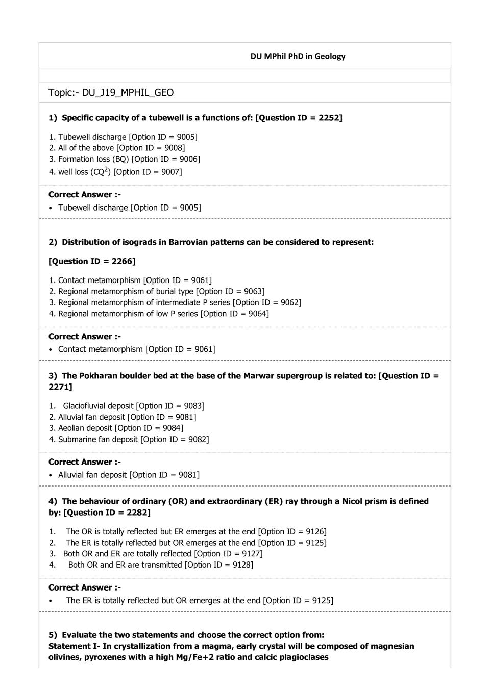
Topic:- DU_J19_MPHIL_GEO
1) Specific capacity of a tubewell is a functions of: [Question ID = 2252]
1. Tubewell discharge [Option ID = 9005]
2. All of the above [Option ID = 9008]
3. Formation loss (BQ) [Option ID = 9006]
4. well loss (CQ2) [Option ID = 9007]
Tubewell discharge [Option ID = 9005]
2) Distribution of isograds in Barrovian patterns can be considered to represent:
[Question ID = 2266]
1. Contact metamorphism [Option ID = 9061]
2. Regional metamorphism of burial type [Option ID = 9063]
3. Regional metamorphism of intermediate P series [Option ID = 9062]
4. Regional metamorphism of low P series [Option ID = 9064]
Contact metamorphism [Option ID = 9061]
3) The Pokharan boulder bed at the base of the Marwar supergroup is related to: [Question ID =
2271]
1. Glaciofluvial deposit [Option ID = 9083]
2. Alluvial fan deposit [Option ID = 9081]
3. Aeolian deposit [Option ID = 9084]
4. Submarine fan deposit [Option ID = 9082]
Alluvial fan deposit [Option ID = 9081]
4) The behaviour of ordinary (OR) and extraordinary (ER) ray through a Nicol prism is defined
by: [Question ID = 2282]
1. The OR is totally reflected but ER emerges at the end [Option ID = 9126]
2. The ER is totally reflected but OR emerges at the end [Option ID = 9125]
3. Both OR and ER are totally reflected [Option ID = 9127]
4. Both OR and ER are transmitted [Option ID = 9128]
The ER is totally reflected but OR emerges at the end [Option ID = 9125]
5) Evaluate the two statements and choose the correct option from:
Statement I- In crystallization from a magma, early crystal will be composed of magnesian
olivines, pyroxenes with a high Mg/Fe+2 ratio and calcic plagioclases
Page 2
(Na+K)/Ca, in Fe+2/Mg and in (Na+K)/Fe+2
[Question ID = 2263]
1. Statement I is correct and II incorrect [Option ID = 9049]
2. Statement II is correct and I incorrect [Option ID = 9050]
3. Statement I and II are incorrect [Option ID = 9052]
4. Statement I and II are correct [Option ID = 9051]
Statement I is correct and II incorrect [Option ID = 9049]
6) Which amongst the following represents crystal form of two non-parallel faces related by a
twofold rotation? [Question ID = 2264]
1. Sphenoid [Option ID = 9056]
2. Pinacoid [Option ID = 9054]
3. Dome [Option ID = 9055]
4. Pedion [Option ID = 9053]
Pedion [Option ID = 9053]
7) Maximum separation of the reflectance value of vegetation, soil, and water is seen in:
[Question ID = 2268]
1. Red band [Option ID = 9071]
2. Blue band [Option ID = 9069]
3. Green band [Option ID = 9070]
4. Infrared band [Option ID = 9072]
Blue band [Option ID = 9069]
8) If competent layers of different thickness are encased close to each other in a relatively
incompetent material, which type of folds is most likely to be produced by layer-parallel
shortening? [Question ID = 2247]
1. harmonic folds [Option ID = 8985]
2. polyharmonic folds [Option ID = 8987]
3. disharmonic folds [Option ID = 8986]
4. no folding of layers. [Option ID = 8988]
harmonic folds [Option ID = 8985]
9) The Cumbum Formation of the Cuddapah Supergroup is characterized by: [Question ID =
2278]
1. Shallow marine carbonates [Option ID = 9110]
2. Deep water facies with black shales [Option ID = 9109]
3. Fluvio-glacial sediments [Option ID = 9112]
4. Shallow water clastics [Option ID = 9111]
Deep water facies with black shales [Option ID = 9109]
Page 3
[Question ID = 2260]
1. Tetraradiate pelvis [Option ID = 9037]
2. Triradiate pelvis [Option ID = 9038]
3. Locomotion [Option ID = 9039]
4. None of the above [Option ID = 9040]
Tetraradiate pelvis [Option ID = 9037]
11) Authigenic precipitation of K rich mica in shallow marine sediments during low
sedimentation rate refers to: [Question ID = 2277]
1. Rapid fall of sea level [Option ID = 9107]
2. Large storm [Option ID = 9108]
3. Flow expansion [Option ID = 9105]
4. Glaucony [Option ID = 9106]
Flow expansion [Option ID = 9105]
12) In symmetry operations reflection in a point, reflection in a line and reflection in a plane can
be represented respectively as: [Question ID = 2265]
1. Inversion, mirror reflection and reversal [Option ID = 9060]
2. Reversal, inversion and mirror reflection [Option ID = 9057]
3. Reversal, mirror reflection and inversion [Option ID = 9059]
4. Inversion, reversal and mirror reflection [Option ID = 9058]
Reversal, inversion and mirror reflection [Option ID = 9057]
13) Mr. Singh looks down onto a broad valley but can't find the stream that carved it. Mr. Singh
(correctly!) concludes that this represents a(n)________ stream valley: [Question ID = 2254]
1. youthful [Option ID = 9015]
2. misfit [Option ID = 9016]
3. impotent [Option ID = 9013]
4. overfit [Option ID = 9014]
impotent [Option ID = 9013]
14) As one moves away from MOR, the depth and age of the oceanic lithosphere ………..due to
compensation: [Question ID = 2286]
1. Both depth and age decrease [Option ID = 9143]
2. Depth decreases but age increases [Option ID = 9144]
3. Depth increases but age remains same [Option ID = 9141]
4. Both depth and age increase [Option ID = 9142]
Depth increases but age remains same [Option ID = 9141]
Page 4
-9.4‰ to -11.3‰ indicate: [Question ID = 2292]
1. Dominance of C3 type of vegetation [Option ID = 9165]
2. Dominance of C4 type vegetation [Option ID = 9166]
3. Dominance of a mixed vegetation [Option ID = 9168]
4. Dominance of CAM vegetation [Option ID = 9167]
Dominance of C3 type of vegetation [Option ID = 9165]
16) Stream saltation is: [Question ID = 2253]
1. a measure of the total dissolved solids in a stream [Option ID = 9012]
2. a jumping process in bed load [Option ID = 9011]
3. the dissolution of salty minerals by flowing water [Option ID = 9009]
4. the grinding of abrasion potholes in a stream bed [Option ID = 9010]
the dissolution of salty minerals by flowing water [Option ID = 9009]
17) The thrusting of the Lesser Himalayan rocks over the Sub-Himalayan rocks is defined by:
[Question ID = 2290]
1. MCT [Option ID = 9158]
2. ITSZ [Option ID = 9157]
3. MFT [Option ID = 9160]
4. MBT [Option ID = 9159]
ITSZ [Option ID = 9157]
18) The last 4,200 years has been classified as the distinct age of our planet is: [Question ID =
2273]
1. Northgrippian [Option ID = 9091]
2. Greenlandian [Option ID = 9089]
3. Calabrian [Option ID = 9092]
4. Meghalayan [Option ID = 9090]
Greenlandian [Option ID = 9089]
19) A region is characterized by the following: few lakes or swamps, well-developed floodplains,
upland divides with even slopes and with rounded-to-knife-edged summits within easy view of
the stream margin. William Morrison Davis would have gazed upon this region and classified it
as: [Question ID = 2255]
1. youthful [Option ID = 9019]
2. old age [Option ID = 9020]
3. adolescent [Option ID = 9017]
4. mature [Option ID = 9018]
adolescent [Option ID = 9017]
Page 5
1. Sponges [Option ID = 9045]
2. Rugose corals [Option ID = 9047]
3. Scleractinian corals [Option ID = 9048]
4. Archaeocyathids [Option ID = 9046]
Sponges [Option ID = 9045]
21) The kerogen consisting of woody terrestrial source material that typically generates gas is:
[Question ID = 2272]
1. Type-I [Option ID = 9085]
2. Type-III [Option ID = 9087]
3. Type-IV [Option ID = 9088]
4. Type-II [Option ID = 9086]
Type-I [Option ID = 9085]
22) The braided channel is defined by: [Question ID = 2289]
1. Low width/depth ratio, steep slope, low bed load, low sinuosity [Option ID = 9155]
2. High width/depth ratio, gentle slope, high bed load, high sinuosity [Option ID = 9156]
3. Low width/depth ration, gentle slope, low bed load, high sinuosity [Option ID = 9154]
4. High width/depth ratio, steep slope, high bed load, low sinuosity [Option ID = 9153]
High width/depth ratio, steep slope, high bed load, low sinuosity [Option ID = 9153]
23) During the last glacial maxima (LGM) the global sea level was ………..lower than it is today:
[Question ID = 2279]
1. 400 m [Option ID = 9113]
2. 100 m [Option ID = 9114]
3. 300 m [Option ID = 9115]
4. 200 m [Option ID = 9116]
400 m [Option ID = 9113]
24) During groundwater pumping through a tubewell at high discharge, the drawdown observed
inside the tubewell: [Question ID = 2251]
1. Is generally more then expected drawdown in the aquifer [Option ID = 9001]
2. Is generally same as expected drawdown in the aquifer [Option ID = 9003]
3. None of the above [Option ID = 9004]
4. Is generally less then expected drawdown in the aquifer [Option ID = 9002]
Is generally more then expected drawdown in the aquifer [Option ID = 9001]
25) If there was no atmosphere, the average surface temperature of the Earth would have been:
[Question ID = 2285]
Page 6
2. 15°C [Option ID = 9140]
3. 20°C [Option ID = 9137]
4. -8.5°C [Option ID = 9139]
20°C [Option ID = 9137]
26) Well loss in pumping well leads to: [Question ID = 2248]
1. Full loss of drawdown [Option ID = 8991]
2. Increase in drawdown [Option ID = 8989]
3. Decrease in drawdown [Option ID = 8990]
4. Loss in recovery of pumping well [Option ID = 8992]
Increase in drawdown [Option ID = 8989]
27) A SOI toposheet 44D/11 has a stream stretch measured as 5.5 cm, this corresponds to
……..km on land: [Question ID = 2281]
1. 5.75 km [Option ID = 9124]
2. 3.75 km [Option ID = 9121]
3. 4 .75km [Option ID = 9122]
4. 2.75 km [Option ID = 9123]
3.75 km [Option ID = 9121]
28) Paired terraces form when ____________ of the river channel: [Question ID = 2270]
1. none of the above [Option ID = 9080]
2. vertical incision is more rapid than lateral migration [Option ID = 9078]
3. lateral migration is more rapid than vertical incision [Option ID = 9077]
4. there is only lateral migration [Option ID = 9079]
lateral migration is more rapid than vertical incision [Option ID = 9077]
29) Which of the following data gives maximum vertical accuracy? [Question ID = 2269]
1. ASTER [Option ID = 9076]
2. SRTM [Option ID = 9075]
3. LiDAR [Option ID = 9073]
4. RADAR [Option ID = 9074]
LiDAR [Option ID = 9073]
30) The mean annual surface/subsurface temperature of dry base glaciers is about: [Question
ID = 2291]
1. 0°C [Option ID = 9162]
2. -10°C [Option ID = 9161]
3. +20°C [Option ID = 9164]
4. -20°C [Option ID = 9163]
Page 7
31) Estimation of Storativity using Theis equation for unsteady state radial flow to a tubewell in
confined aquifer can be done using:
[Question ID = 2250]
1. Drawdown & time data of the observation well near pumping well [Option ID = 8997]
2. None of the above [Option ID = 9000]
3. Only after we estimate transmissivity value [Option ID = 8998]
4. Drawdown & time data of the observation well near pumping well and only after we estimate
transmissivity value [Option ID = 8999]
Drawdown & time data of the observation well near pumping well [Option ID = 8997]
32) The river type defined by multiple channels, large stable islands and dominance of
suspension load is: [Question ID = 2275]
1. Meandering River [Option ID = 9098]
2. Anastomosing river [Option ID = 9099]
3. Braided River [Option ID = 9100]
4. Straight river [Option ID = 9097]
Straight river [Option ID = 9097]
33) The sedimentary structures marked by mud drapes and bipolar cross stratification
demarcate: [Question ID = 2276]
1. Deep water currents [Option ID = 9103]
2. Tidal current processes [Option ID = 9102]
3. Waves and storm processes [Option ID = 9101]
4. Fluvial processes [Option ID = 9104]
Waves and storm processes [Option ID = 9101]
34) The sedimentary shell of Earth is marked by ~50% of …………… [Question ID = 2288]
1. Limestone [Option ID = 9152]
2. Sandstone [Option ID = 9150]
3. Shale/mudrocks [Option ID = 9149]
4. Conglomerate [Option ID = 9151]
Shale/mudrocks [Option ID = 9149]
35) Amount of the bed load in the sedimentary flux from all rivers to ocean is commonly:
[Question ID = 2284]
1. More than suspended load [Option ID = 9134]
2. <10 % of the suspended load [Option ID = 9135]
Page 8
4. Equal to suspended [Option ID = 9133]
Equal to suspended [Option ID = 9133]
36) In a thrust sequence, the first (earliest) thrust forms ahead and successively younger
thrusts form in the hanging wall of the preceding thrusts. The sequence is called: [Question ID =
2246]
1. none of the above. [Option ID = 8984]
2. a break-back sequence [Option ID = 8982]
3. an irregular sequence [Option ID = 8983]
4. a piggyback sequence [Option ID = 8981]
a piggyback sequence [Option ID = 8981]
37) Assertion (A): The amount and character of strain can be assessed with greater precision in
deformed fossils than in inorganic structures
Reasoning ( R): Undeformed specimens of same species better preserve original Shape [Question
ID = 2259]
1. A is false [Option ID = 9035]
2. R is false [Option ID = 9036]
3. R explains A [Option ID = 9033]
4. R does not explain A [Option ID = 9034]
R explains A [Option ID = 9033]
38)
[Question ID = 2243]
1. Non-plane, cylindrical [Option ID = 8971]
2. Non-plane, non-cylindrical [Option ID = 8970]
3. Plane, non-cylindrical [Option ID = 8969]
4. Plane cylindrical [Option ID = 8972]
Plane, non-cylindrical [Option ID = 8969]
Page 9
[Question ID = 2245]
1. Simple shear, General shear, Pure shear [Option ID = 8978]
2. Pure shear, General shear, Simple shear [Option ID = 8979]
3. Simple shear, Pure shear, General shear [Option ID = 8980]
4. Pure shear, Simple shear, General shear [Option ID = 8977]
Pure shear, Simple shear, General shear [Option ID = 8977]
40) The upstream geomorphic response of dam on a river profile is characterised by: [Question
ID = 2274]
1. Flattening of the profile and deltaic deposition [Option ID = 9095]
2. Steepening of the profile and increased erosion [Option ID = 9093]
3. Steepening of the profile and increased deposition [Option ID = 9094]
4. Flattening of the profile and increased incision [Option ID = 9096]
Steepening of the profile and increased erosion [Option ID = 9093]
41) A polar wandering curve: [Question ID = 2256]
1. is a graph utilized to interpret the Richter Scale [Option ID = 9024]
2. shows that the continents wandered relative to generally-fixed pole positions [Option ID = 9023]
3. shows that the magnetic poles wandered relative to fixed continents [Option ID = 9021]
4. shows that the rotational poles wandered to fixed continents [Option ID = 9022]
shows that the magnetic poles wandered relative to fixed continents [Option ID = 9021]
42) Which of the following facies is absent in the low P series of metamorphism of mafic rocks?
[Question ID = 2267]
1. Epidote hornfels facies [Option ID = 9068]
2. Epidote amphibolite facies [Option ID = 9067]
3. Greenschist facies [Option ID = 9065]
4. Sanidintie facies [Option ID = 9066]
Greenschist facies [Option ID = 9065]
43) Which of the following oceanic processes accounts for most of the earth’s sedimentary rock
containing phosphate? [Question ID = 2258]
Page 10
2. Equatorial divergence [Option ID = 9031]
3. Coastal upwelling [Option ID = 9030]
4. Thermohaline circulation [Option ID = 9029]
Thermohaline circulation [Option ID = 9029]
44) Which of the following is considered as the largest extinction in Earth’s history that killed
90-96% of the species? [Question ID = 2280]
1. Ordovician-Silurian [Option ID = 9117]
2. Late Devonian [Option ID = 9118]
3. Cretaceous-Paleogene [Option ID = 9120]
4. Permian-Triassic [Option ID = 9119]
Ordovician-Silurian [Option ID = 9117]
45) The Skolithos assemblage of Ichnofacies defined by vertical tube-like features refer to:
[Question ID = 2283]
1. Sandy shore [Option ID = 9129]
2. Sub-littoral [Option ID = 9130]
3. Bathyal zone [Option ID = 9131]
4. Abyssal Zone [Option ID = 9132]
Sandy shore [Option ID = 9129]
46) ————————— structures indicate evolution from a common ancestor
[Question ID = 2261]
1. Analogous [Option ID = 9041]
2. Homologous [Option ID = 9042]
3. vestigial [Option ID = 9043]
4. None of the above [Option ID = 9044]
Analogous [Option ID = 9041]
47) A fold-mullion structure is typically the surface expression of hinges of
[Question ID = 2244]
1. cuspate-lobate folds [Option ID = 8974]
2. chevron folds [Option ID = 8975]
3. none of the above. [Option ID = 8976]
4. ptygmatic folds [Option ID = 8973]
ptygmatic folds [Option ID = 8973]
48) Ekman transport occurs in which part of the ocean [Question ID = 2257]
Page 11
2. Meso pelagic layer [Option ID = 9026]
3. Ocean bottom [Option ID = 9028]
4. Bathy pelagic layer [Option ID = 9027]
Upper ocean [Option ID = 9025]
49) The significant water level fluctuation is generally:
[Question ID = 2249]
1. Both Inversely related to change of atmospheric pressure in confined aquifers and directly related to
change of Tidal amplitude in unconfined and confined aquifers [Option ID = 8995]
2. Directly related to change of Tidal amplitude in unconfined and confined aquifers [Option ID = 8994]
3. Inversely related to change of atmospheric pressure in confined aquifers [Option ID = 8993]
4. None of the above [Option ID = 8996]
Inversely related to change of atmospheric pressure in confined aquifers [Option ID = 8993]
50) The solar radiation/electromagnetic spectrum provides …………….of all energy received by
the Earth: [Question ID = 2287]
1. 80.98% [Option ID = 9147]
2. 99.98% [Option ID = 9148]
3. 10.98% [Option ID = 9145]
4. 50.98% [Option ID = 9146]
10.98% [Option ID = 9145]
Document Details
| Board / Org | NTA |
| Exam | DUET |
| Type | Question Paper |
| Pages | 11 |
| Updated | 30 Apr 2026 |