ISC Class 12 Question Paper 2020 for Geography
Finished viewing? Save it for later —
Download ISC Class 12 Question Paper 2020 for Geography (PDF · 5 pages)About ISC Class 12 Question Paper 2020 for Geography
ISC Class 12 Question Paper 2020 for Geography is available here for free download. Published by CISCE for Class 12, this question paper can be viewed online or downloaded as a PDF (5 pages). Candidates preparing for Class 12 can use ISC Class 12 Question Paper 2020 for Geography to understand the exam pattern, the type of questions asked, and the overall difficulty level.
Frequently Asked Questions
How can I download ISC Class 12 Question Paper 2020 for Geography?
Open this page and click the Download button to save ISC Class 12 Question Paper 2020 for Geography as a PDF. It is completely free on AglaSem Docs.
Is ISC Class 12 Question Paper 2020 for Geography free to download?
Yes. ISC Class 12 Question Paper 2020 for Geography can be viewed online and downloaded as a PDF free of cost on AglaSem Docs.
How many pages does ISC Class 12 Question Paper 2020 for Geography have?
ISC Class 12 Question Paper 2020 for Geography contains 5 pages, which you can read online or download together as a single PDF.
Where can I find more Class 12 study material?
You can find more Class 12 question papers, sample papers, syllabus, and answer keys on AglaSem Docs.
ISC Class 12 Question Paper 2020 for Geography – Text
Read the full text of this question paper below — useful to quickly search, copy and reference the content online without downloading the PDF.
📄 View text version (5 pages)
Page 1
PAPER 1
(THEORY)
(Maximum Marks: 70)
(Time allowed: Three hours)
(Candidates are allowed additional 15 minutes for only reading the paper.
They must NOT start writing during this time.)
Answer Sections A and B from Part I which are compulsory.
Answer any four questions from Part II.
Sketch maps and diagrams should be drawn wherever they serve to illustrate your answer.
The intended marks for questions or parts of questions are given in brackets [ ].
------------------------------------------------------------------------------------------------
PART I (30 Marks)
Answer all questions.
SECTION A
Question 1 [10 2]
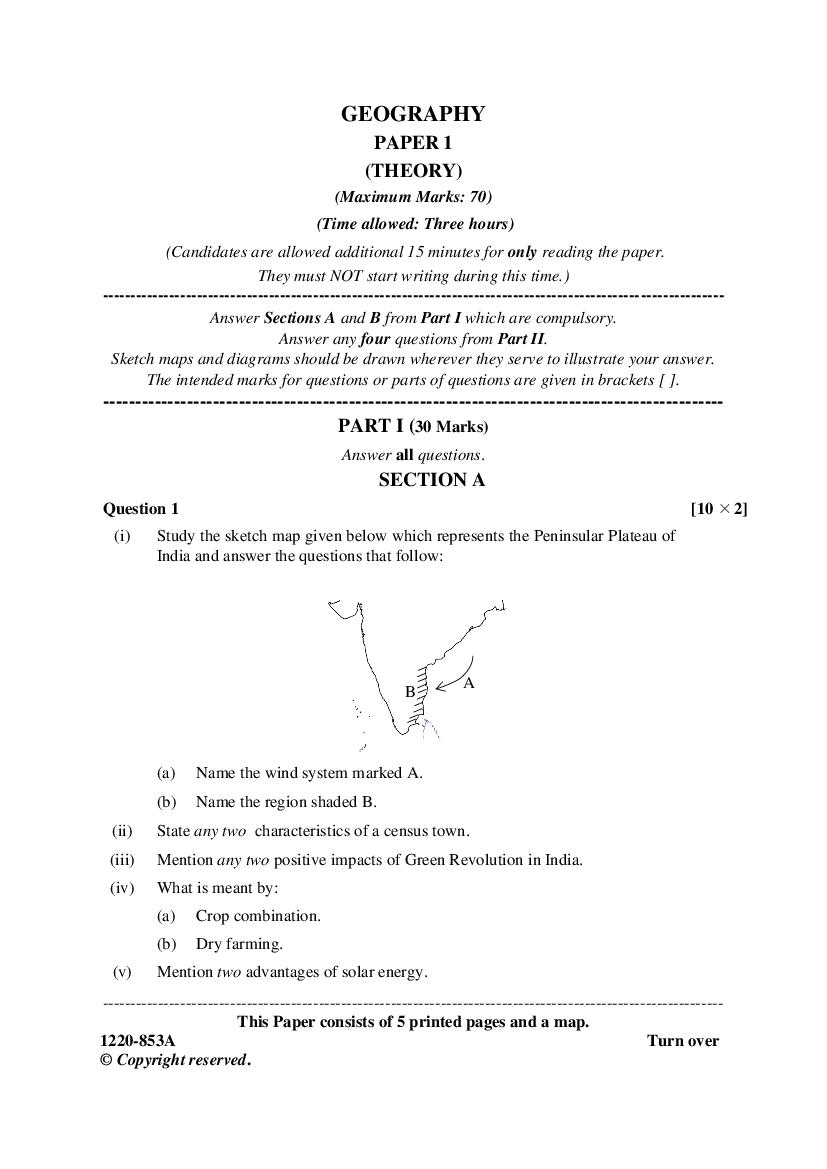
(i) Study the sketch map given below which represents the Peninsular Plateau of
India and answer the questions that follow:
A
B
(a) Name the wind system marked A.
(b) Name the region shaded B.
(ii) State any two characteristics of a census town.
(iii) Mention any two positive impacts of Green Revolution in India.
(iv) What is meant by:
(a) Crop combination.
(b) Dry farming.
(v) Mention two advantages of solar energy.
This Paper consists of 5 printed pages and a map.
© Copyright reserved.
Page 2
of India.
(vii) Explain the difference between a key industry and a foot loose industry.
(viii) Mention any two factors that influence inland water transport.
(ix) What are the two factors that govern the growth of Chota Nagpur industrial
region?
(x) Name a state each that shares its boundary with Chhattisgarh in the:
(a) North
(b) East
SECTION B
Question 2 [10]
On the outline map of India provided:
(a) Mark and label the Satpura mountain range.
(b) Shade and label the northern most plain on the eastern coast.
(c) Shade and label a well-defined drought prone area in the western part of India.
(d) Identify and label the city marked A.
(e) Shade and name the state which has the highest sex ratio in India.
(f) Trace the route of National Highway 1 and name any one terminal city.
(g) Identify and name the nuclear power plant marked B.
(h) Identify and label the waterbody marked C.
(i) Mark and label Shipki-La Pass.
(j) Shade and label Malwa Plateau.
Note: All the map work, including legend (Index) should be done on the map sheet only.
PART II (40 Marks)
Answer any four questions.
Question 3
(a) Briefly explain how the Northern Plain of India was formed. [3]
(b) For any country, about 33·3% of its total geographical area should be under forest [2]
cover for ecological balance, but India has only 21·85% of its area under forest.
Mention any four human activities which are responsible for the low forest cover.
2
1220-853A
Page 3
questions:
City T/R J F M A M J J A S O N D
T 24 24 26 28 30 29 27 27 27 28 27 25
A
R 4 2 2 2 18 465 613 329 286 65 18 2
T = Mean monthly temperature in degree Celsius (oC)
R = Average monthly rainfall in millimetres
(i) Name the winds bringing heavy rainfall to station A.
(ii) Calculate the annual range of temperature for station A.
(d) (i) Name the type of vegetation found in the river deltas of India. [3]
(ii) Name an important variety of tree found in (d) (i) above.
(iii) State one characteristic feature of the mountain vegetation.
Question 4
(a) Give a reason for each of the following: [3]
(i) The population period of 1951-1981 was termed as ‘period of population
explosion’.
(ii) There is growth of slums and squatter settlement in urban areas of India.
(iii) Break-in-transportation boosts urbanisation.
(b) Give two reasons why Uttar Pradesh has a higher density of population than [2]
Arunachal Pradesh.
(c) Explain any two reasons for large scale migration to Delhi. [2]
(d) Explain how the following factors influence population distribution in India: [3]
(i) Climate
(ii) Landform
(iii) Fertility of soil
Question 5
(a) (i) What is meant by sustainable development? [3]
(ii) State any two aspects of environmental management.
(b) Discuss any three emerging water problems in India. [3]
(c) What are the two disadvantages of tank irrigation in India? [2]
(d) Mention any two advantages of canals as modern means of irrigation. [2]
3
Page 4
(a) Explain why:
(i) Pulses are grown as rotational crops. [3]
(ii) The yield of sugarcane is high in Peninsular India.
(iii) Hill slopes are best suited for tea cultivation.
(b) Give three reasons to explain the poor development of offshore fishing in India. [3]
(c) Name the mineral associated with each of the following places: [2]
(i) Keonjhar district of Odisha.
(ii) Nagpur in Maharashtra.
(iii) Bhilwara district of Rajasthan.
(iv) Karanpura in Jharkhand.
(d) (i) Why is there a need to promote non-conventional energy resources? [2]
(ii) Name any two types of the non-conventional energy resources.
Question 7
(a) Give a reason for each of the following: [3]
(i) Road transport in India is more flexible than rail transport.
(ii) Transport plays a vital role in economic development of India.
(iii) Rivers of Peninsular India are not much suited for navigation.
(b) (i) Why are railways poorly developed in North-East India? [3]
(ii) What is the difference between a harbour and a port?
(iii) Why is there a contrast between Eastern and Western coastal rail network?
(c) What is Prasar Bharti? Name its two constituents. [2]
(d) (i) Name the tidal port located at the eastern end of Gulf of Kutch. [2]
(ii) Name a port on east Coast of India which is often hit by cyclones in the
months of October-November.
Question 8
(a) Mention any two factors responsible for the location of Tata Iron and Steel [2]
Industry at Jamshedpur.
(b) What is meant by industrial inertia? Give an example. [2]
(c) (i) Which two factors determine the localisation of aluminium industry? [3]
(ii) Name any two products made from aluminium.
4
1220-853A
Page 5
foreign tourists in the country.
(ii) Name an important hill station in West Bengal.
Question 9
(a) Discuss any three steps involved in a geographer’s analysis of regional [3]
development.
(b) (i) What is meant by multilevel planning? [2]
(ii) Define the term development.
(c) (i) Name the largest coal field in Chhattisgarh. [3]
(ii) Why is the above-mentioned coal field important?
(iii) State the latitudinal extent of Chhattisgarh.
(d) What is a micro-region? Give an example. [2]
5
Document Details
| Board / Org | CISCE |
| Exam | Class 12 |
| Type | Question Paper |
| Pages | 5 |
| Language | english |
| Updated | 22 Jul 2026 |