Kerala Plus Two Answer Key 2025 Geography
Finished viewing? Save it for later —
Download Kerala Plus Two Answer Key 2025 Geography (PDF · 7 pages)About Kerala Plus Two Answer Key 2025 Geography
Kerala Plus Two Answer Key 2025 Geography is available here for free download. Published by Kerala Board for Class 12, this answer key can be viewed online or downloaded as a PDF (7 pages). Candidates preparing for Class 12 can use Kerala Plus Two Answer Key 2025 Geography to understand the exam pattern, the type of questions asked, and the overall difficulty level.
Frequently Asked Questions
How can I download Kerala Plus Two Answer Key 2025 Geography?
Open this page and click the Download button to save Kerala Plus Two Answer Key 2025 Geography as a PDF. It is completely free on AglaSem Docs.
Is Kerala Plus Two Answer Key 2025 Geography free to download?
Yes. Kerala Plus Two Answer Key 2025 Geography can be viewed online and downloaded as a PDF free of cost on AglaSem Docs.
How many pages does Kerala Plus Two Answer Key 2025 Geography have?
Kerala Plus Two Answer Key 2025 Geography contains 7 pages, which you can read online or download together as a single PDF.
Where can I find more Class 12 study material?
You can find more Class 12 question papers, sample papers, syllabus, and answer keys on AglaSem Docs.
Kerala Plus Two Answer Key 2025 Geography – Text
Read the full text of this answer key below — useful to quickly search, copy and reference the content online without downloading the PDF.
📄 View text version (7 pages)
Page 1
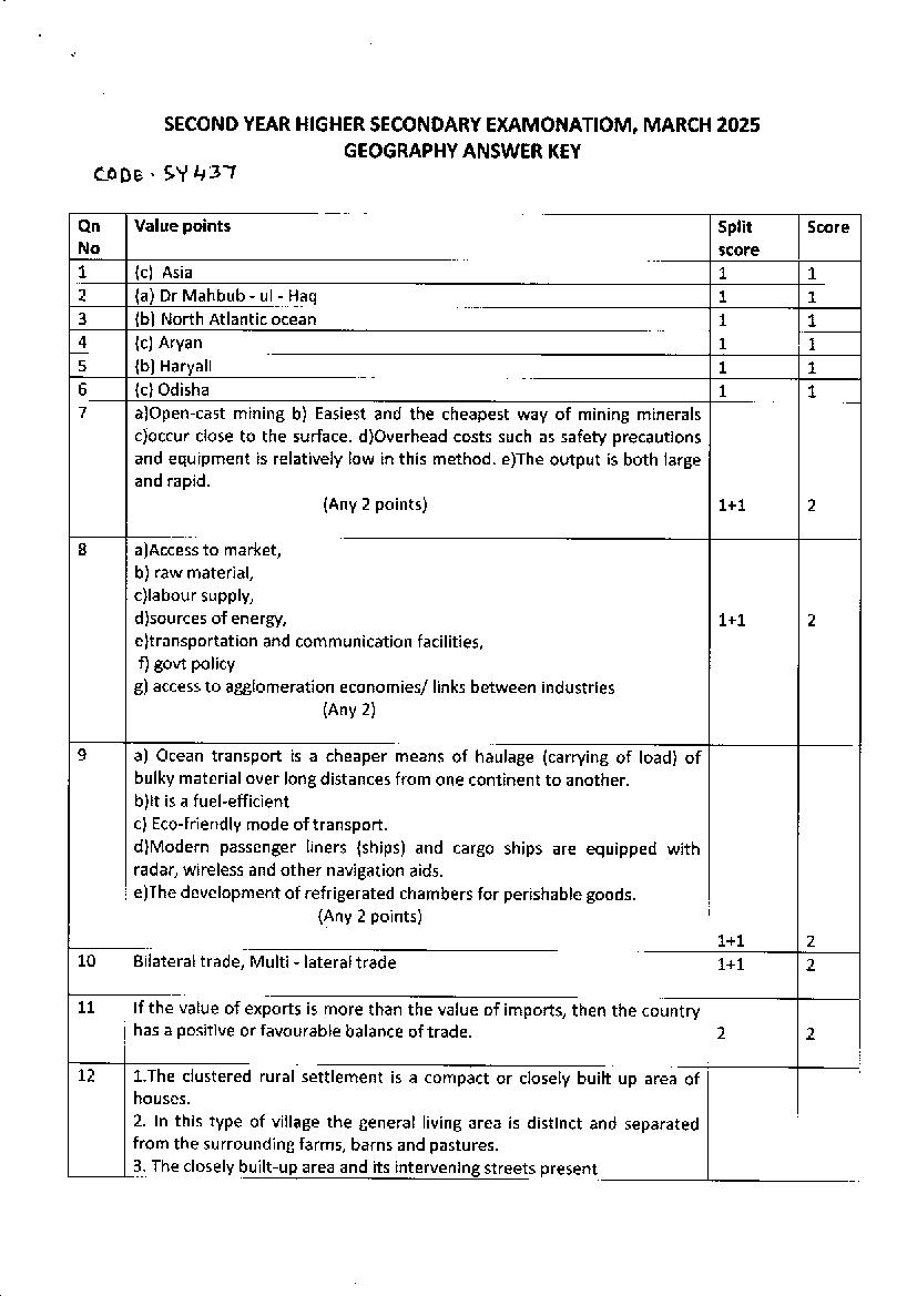
GEOGRAPHY ANSWER KEY
coDe . 9Y 437
Qn Value points Split Score
No gdtrrq
L (c) Asia L L
2 (a) Dr Mahbub - ul- Haq L L
3 (b) North Atlantic ocean 1 L
4 (c) Aryan t L
5 (b) Haryali L L
5 (c)Odisha 1 1
7 a)Open-cast mining b) Easiest and the cheapest way of mining minerals
c)occur close to the surface. d)Overhead costs such as safety precautions
and equipment is relatively low in this method. e)The output is both large
and rapid.
(Any 2 points) 1+1 2
8 a)Access to market,
b) raw material,
c)labour supply,
d)sources of energy, 1+1 2
e)transportation and com m u n ication facilities,
f)gorrt policy
g) access to agglomeration economies/ links between industries
(Any 2)
9 a) Ocean transport is a cheaper means of haulage (carrying of load) of
bulky material over long distances from one continent to another.
b)lt is a fuel-efficient
c) Eco-friendly mode of transport
d)Modern passenger liners (ships) and cargo ships are equipped with
radar, wireless and other navigation aids.
e)The development of refrigerated chambers for perishable goods.
1+1 2
10 Bilateral trade, Multi - lateral trade 1+1 2
11 lf the value of exports is more than the value of imports, then the country
has a positive or favourable balance of trade. 2 2
L2 1.The clustered rura! settlement is a compact or closely built up area of
houses.
2. !n this type of village the general living area is distinct and separated
from the surrounding farms, barns and pastures.
3. The closely built-up area and its i streets present
Page 2
Iinear, etc.
5. Such settlements are generally found in fertile alluvial plains and in the
northeastern states.
6.Sometimes, people live in compact village for security or defence
reasons, such as in the Bundelkhand region of central lndia and in 1+1 2
Nagaland. ln Rajasthan, scarcity of water has necessitated compact
settlement for maximum utilisation of available water resources.
(Anv 2 points)
13 O increases water availability
o checks the declining groundwater table
O improves the quality of groundwater through dilution of
contaminants, like fluoride and nitrates
O prevents soil erosion, and flooding
o arrests salt water intrusion in coastal areas if used to recharge aquifers
(Any 2 points) 1+1 2
L4 o More equitably distributed
. Environment-friendly
o Provide more sustained,
o Cheaper energy after the initia! cost is taken care of.
L+1 2
15 a)Radio broadcasting started in lndia in 1923 by the Radio Club of Bombay.
b)Since then, it gained immense popularity and changed the socio-cultural
Iife of people.
c) lt was changed to All lndia Radio in 1936 and to Akashwani in 1957.
d)Al! tndia Radio broadcasts a variety of programmes related to
information, education and entertainment. Special news bulletins are also
broadcast at specific occasions like session of parliament and state
legislatures
1+1 2
16 a)Roads !aid along internationa! boundaries are called border roads.
b)They play an important role in integrating people in remote areas with
major cities and providing defence.
c)Almost all countries have such roads to transport goods to border
villages and military camps.
d)ln lndia, the Border Road Organisation (BRO) was established in May
1960 for accelerating economic development and strengthening defence
preparedness through rapid and coordinated improvement of strategically
important roads along the northern and north-eastern boundary of the
country.
Page 3
L7 a The chief gateways of the world of international trade are the
harbours and ports.
5 Cargoes and travellers pass from one part of the world to another
through these ports.
al The ports proyide facilities of docking, loading, unloading and the
storage facilities for cargo.
1+1 2
18 1. Sewage Disposa!
2. !ndustrtial effluents,
3. Agricultural eff!uents 1+1 2
4. Urban run-off
2
19 (i ) Neo determinisn or Stop and Go determinism LY2
(ii) Griffith Taylor LY2 3
20 There are three components of population change - births, deaths and lz+/z+/z
migration.
o The crude birth rate (cBR) is expressed as number of live births in a
year per thousand of population. lt is calculated as: cBR B/p x10008 %
=
E Here, cBR = crude Birth Rate; B = live births during the year; p=
Estimated mid year population of the area.
. crude Death Rate (cDR) is expressed in terms of number of deaths in
a particular year per thousand of population in a particular region. cDR % 3
is calculated as: CDR =D/p x 1000
Here, cDR=crude Death Rate; D= Number of deaths; p=Estimated
mid-year population of that year.
o Migration is the permanent, temporary or seasona! change of
%
residence.
2L . Equity, lzx 4
. Sustainability, 3
o Productivity L
. Empowerment.
ation of one
22 :l Primit lve su bsistence aSncu Iture o f shifting cultivation ls wide ly
practised by many tribes in the tropics, especially IN Africa, south
and central America and south east Asia .
a shifting cultivation is thus, also called slash and burn agriculture.
a The cultivated are ve small and cultivation is done with
Page 4
al After sometime (3 to 5 years) the soi! looses its fertility and the
farmer shifts to another parts and clears other patch of the forest
for cultivation.
o It is prevalent in tropica! region in different names, e.g. Jhuming
Jhuming in North eastern states of lndia, Milpa in centra! America
and Mexico and Ladang in lndonesia and Malaysia.
(Any 3 points)
1+1+1 3
23 (i) Opportunities emerging from the lnformation and Communication
Technology based development is unevenly distributed across the globe.
While developed countries in general have surged forward, the developing LY2
countries have lagged behind and this is known as the digital divide.
3
(ii) Quaternary activities involve some of the following: the collection,
production and dissemination of information or even the production of L%
information.
o Quaternary activities centre around research, development and
may be seen as an advanced form of services involving specialised
knowledge and technical skills.
24 (a)Trans - Canadian railway 7
o Runs between halifax and Vancouver.
o This rail-line passes through Montreal, Ottawa, Winnipeg and
Calgary for a distance of 7,050 km.
o tt was constructed in 1885, initially as part of an agreement to
make British Columbia on the west coast join the Federation of
States. 3
. This line is the economic artery of Canada.
o Wheat and meat are the important exports on this route.
1+1
25 Kharif Rice, Cotton, Bajra, Maize, Ragi,Jowar, Tur, Jowar, Tr+/,
Groundnut (Any 1)
October - March Wheat, Gram, Rapeseeds, Rice, Maize,
Tz+Tz
Ragi,Mustard, Barley, Groundnut,Jowar (Any 1) 3
Tz +lz
Zaid ril - June
26 o Hill Area Development Programmes were initiated during the Fifth
Five Year
5 Plan covering 15 districts comprising all the hilly districts of Uttar
Pradesh (present Uttarakhand), Mikir Hill and North Cachar hills of
Assam, Darjeeling district of West Bengal and Nilgiri district of Tamil
Nadu.
Page 5
of the hill areas through development of horticulture,plantation,
agriculture, anima! husbandry, poultry, forestry and small-scale and
village industry.
(Any 3 points)
1+t+1 3
27 (i) Availability of water: Water is the most important factor for life. So,
people prefer to live in areas where fresh water is easily available. Water is
used for drinking bathing and cooking - and also for cattle, crops,
industries and navigation. lt is because of this that river valleys are among
the most densely populated areas of the world.
(ii) Landforms: People prefer living on flat plains and gentle slopes. This is
because such areas are favourable for the production of crops and to build
roads and industries. The mountainous and hilly areas hinder the
development of transport network and hence initially do not favour
agricultural and industrial development. So, these areas tend to be less
populated. The Ganga plains are among the most densely populated areas
of the world while the mountains zones in the Himalayas are scarcely
populated.
(iii) Climate: An extreme climate such as very hot or cold deserts are
uncomfortable for human habitation. Areas with a comfortable climate,
where there is not much seasonal variation attract more people. Areas
with very heavy rainfall or extreme and harsh climates have Iow
population. Mediterranean regions were inhabited from early periods in
history due to their pleasant climate.
(iv) Soils: Fertile soils are important for agricultural and allied activities.
Therefore, areas which have fertile loamy soils have more people living on
them as these can support intensive agriculture.
To identify the factors Yzx4
4
To explain (1 point each) lzx4
28
o Co-operativeFarming: 1+1
o Collective Farming: 4
Yzx4
To identify the type of farming
To explain (2 points
"L.frt
Page 6
(a) agro-based;
(b) mineral based; /zx4
(clchemical based; 4
(d)forest based: /zx4
and (e) animal based. (Any a)
Write one point each about any four tvpes or one example each
30 o Phase I From 1901 - 1921
o Phase ll L92L - 1951
o Phase ll 1951- 1981 Yzx4
o Phase lV 1981till present
4
Explanation of any one phase (2 points) 1+1
31 Administrative towns and cities
lndustrialtowns
Transport Cities
Commercialtowns
Mining towns
Garrisson- Cantonment towns
Educational towns
Religious and cultura! towns Yzx4
Tourist towns (Any a)
4
Explanation or one example each /zx 4
32 (a) Arunachal Pradesh
(b) Assam
(c) Jharia
(d) Paradwip Port
Page 7
To locate %x4
2. e3 enlLl . A.v
3 .8 a
4, G1 aqaqL.ar K.< 7
Document Details
| Board / Org | Kerala Board |
| Exam | Class 12 |
| Type | Answer Key |
| Pages | 7 |
| Updated | 22 Jul 2026 |