PU CET PG 2017 Question Paper Remote Sensing _ GIS
Finished viewing? Save it for later —
Download PU CET PG 2017 Question Paper Remote Sensing _ GIS (PDF · 13 pages)About PU CET PG 2017 Question Paper Remote Sensing _ GIS
PU CET PG 2017 Question Paper Remote Sensing _ GIS is available here for free download. Published by Punjab University for PU CET PG, this question paper can be viewed online or downloaded as a PDF (13 pages). Candidates preparing for PU CET PG can use PU CET PG 2017 Question Paper Remote Sensing _ GIS to understand the exam pattern, the type of questions asked, and the overall difficulty level.
Frequently Asked Questions
How can I download PU CET PG 2017 Question Paper Remote Sensing _ GIS?
Open this page and click the Download button to save PU CET PG 2017 Question Paper Remote Sensing _ GIS as a PDF. It is completely free on AglaSem Docs.
Is PU CET PG 2017 Question Paper Remote Sensing _ GIS free to download?
Yes. PU CET PG 2017 Question Paper Remote Sensing _ GIS can be viewed online and downloaded as a PDF free of cost on AglaSem Docs.
How many pages does PU CET PG 2017 Question Paper Remote Sensing _ GIS have?
PU CET PG 2017 Question Paper Remote Sensing _ GIS contains 13 pages, which you can read online or download together as a single PDF.
Where can I find more PU CET PG study material?
You can find more PU CET PG question papers, sample papers, syllabus, and answer keys on AglaSem Docs.
PU CET PG 2017 Question Paper Remote Sensing _ GIS – Text
Read the full text of this question paper below — useful to quickly search, copy and reference the content online without downloading the PDF.
📄 View text version (13 pages)
Page 1
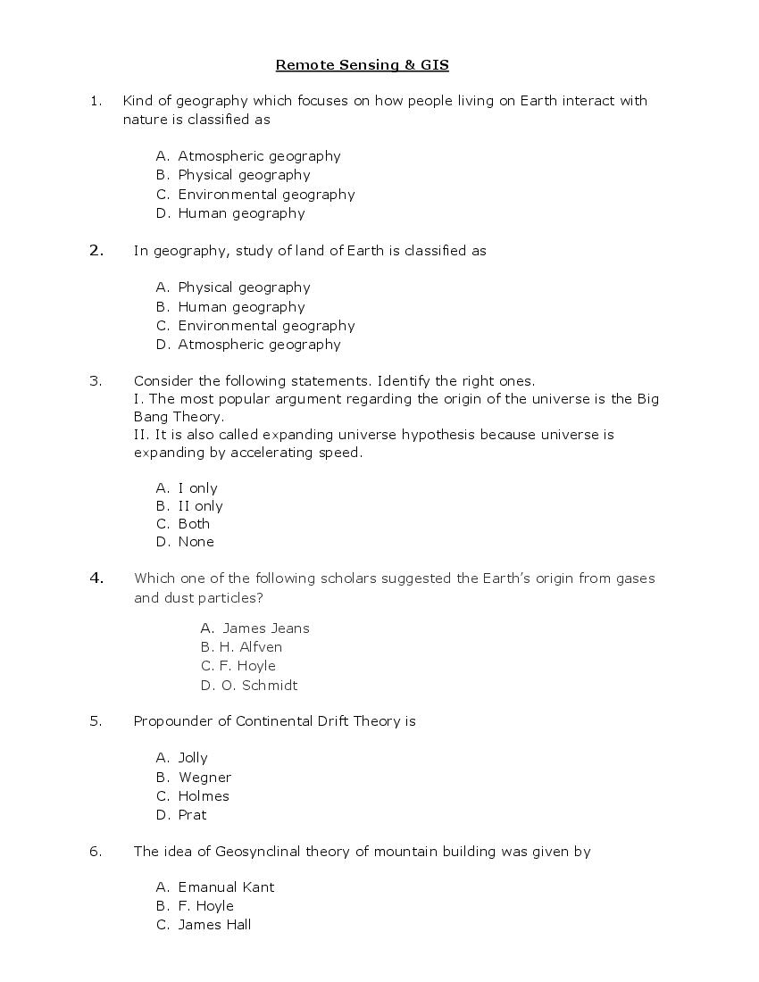
1. Kind of geography which focuses on how people living on Earth interact with
nature is classified as
A. Atmospheric geography
B. Physical geography
C. Environmental geography
D. Human geography
2. In geography, study of land of Earth is classified as
A. Physical geography
B. Human geography
C. Environmental geography
D. Atmospheric geography
3. Consider the following statements. Identify the right ones.
I. The most popular argument regarding the origin of the universe is the Big
Bang Theory.
II. It is also called expanding universe hypothesis because universe is
expanding by accelerating speed.
A. I only
B. II only
C. Both
D. None
4. Which one of the following scholars suggested the Earth’s origin from gases
and dust particles?
A. James Jeans
B. H. Alfven
C. F. Hoyle
D. O. Schmidt
5. Propounder of Continental Drift Theory is
A. Jolly
B. Wegner
C. Holmes
D. Prat
6. The idea of Geosynclinal theory of mountain building was given by
A. Emanual Kant
B. F. Hoyle
C. James Hall
Page 2
7. Tremendous compressional forces exerted on rock layers by geological
movements causes rock layers to
A. Crack
B. Bend
C. Heat up
D. Vibrate
8. Normal fault is caused by
A. Compression
B. Tension
C. Expansion
D. Collision
9. Rocks that are formed through solidification and cooling of lava are classified
as
A. Allotropic rocks
B. Metamorphic rocks
C. Igneous rocks
D. Sedimentary rocks
10. Rocks that are formed at surface of Crust due to melting of rocks are
classified as
A. Fabric of igneous rocks
B. Extrusive igneous rocks
C. Intrusive igneous rocks
D. Igneous sediments
11. Which of the following is not an example of a volcanic mountain?
A. Mt. Vesuvius
B. Mt. Kanchenjanga
C. Mt. Kalimanjaro
D. Mt. Fujiyama
12. Number of mountains in Tibetan Plateau whose height are more than 8,000
meters are
A. 20
B. 18
Page 3
D. 16
13. Maximum height of hills is usually
A. 950 meters
B. 800 meters
C. 750 meters
D. 600 meters
14. Residual hill in the desert
A. Inlier
B. Inselberg
C. Playa
D. Pediment
15. The instrument used for recording earthquake waves is
A. Barograph
B. Hydrograph
C. Pantograph
D. Seismograph
16. Average weather condition of specific area over many years is called
A. Atmosphere
B. Climate
C. Weather
D. Relief
17. Which of the following factors is not associated with insolation at the surface
of the earth?
A. Rotation of earth on its axis
B. Angle of inclination of the sun’s rays
C. Transparency of the atmosphere
D. None of the above
18. Arrange the following gases present in atmosphere in the decreasing order of
volume:
(I) Helium
Page 4
(III) Nitrogen
(IV) Argon
A. (I), (II), (III), (IV)
B. (II), (III), (IV), (I)
C. (III), (II), (IV), (I)
D. (IV), (III), (I), (II)
19. Heating of earth unevenly gives rise to formation of
A. Meridian line
B. Pressure belts
C. Longitudinal lines
D. Hemispheres
20. Circular patterns through which air moves is called
A. Pressure belts
B. Convection cells
C. Latitude
D. Longitude
21. As compared to cold air, warm air is
A. Unsaturated
B. Lighter
C. Heavier
D. Saturated
22. Form of summer precipitation in cool temperate climate is
A. Convectional rain
B. Refraction rain
C. Cirrus rain
D. Cumulus rain
23. The contact of two air masses differing sharply in humidity originates:
A. Stratospheric instability
B. Tropical cyclones
C. Inter tropical convergence
D. Temperate cyclones
24. What is the most important factor in thunderstorms development?
Page 5
B. Atmospheric pressure
C. Atmospheric instability
D. Temperature inversion
25. Which factors influence ocean currents?
(i) Density of the water
(ii) Convection currents
(iii) Coriolis force (Earth’s rotation)
(iv) Winds across the ocean
A. (i), (ii) & (iii)
B. (ii), (iii) & (iv)
C. (i), (ii) & (iv)
D. (i), (ii), (iii) & (iv)
26. Which of the following influence the oceanic salinity?
A. Land
B. Wind
C. River
D. Ash from volcanoes
27. In which of the following the direction of Ocean currents are reversed with
season?
A. Pacific Ocean
B. Atlantic Ocean
C. Indian Ocean
D. Arctic Ocean
28. Which of the following ocean current is not found in northern hemisphere?
A. Oyashio Current
B. West wind drift
C. Gulf stream
D. Canaries current
29. Which of the following is incorrect about tides?
A. Neap tide has maximum range of tide.
B. Spring tide occurs when sun, moon and earth are in a straight line.
C. Neap tide occurs when moon and sun are perpendicular to each
other.
D. Time between the high tide and low tide, when the water level is
falling is called ebb.
30. In sea, plants are restricted upto the depth of
Page 6
B. 1000 m
C. 200 m
D. 20 m
31. Maps that shows individual countries and each country is separated by
national boundary are called
A. Airlines maps
B. Political maps
C. Thematic maps
D. Resource maps
32. Two cities that are 2 1/2 inches apart on a map are actually 750 miles apart.
Therefore, one inch on the map is equal to how many miles?
A. 250
B. 300
C. 350
D. 400
33. Maps with minute details are drawn on ______ scale:
A. Small
B. Large
C. Medium
D. None of these
34. The unit of Representative Fraction (R.F.) is
A. Centimeter
B. Square centimeter
C. Cubic centimeter
D. None of these
35. A compass indicates direction by detecting
A. Pressure differences
B. Variations in gravity
C. Solar wind directions
D. Magnetic lines of force
36. In which direction could one travel from the North Pole?
A. South
B. East
C. West
Page 7
37. A compass bearing of 165 degrees describes a
A. Northwesterly direction
B. Southeasterly direction
C. Southwesterly direction
D. northeasterly direction
38. Proportional compass used for enlargement and reduction of maps belongs to
which method
A. Geometrical
B. Mechanical
C. Projectional
D. Photographic
39. Contour interval is
A. Inversely proportional to the scale of the map
B. Directly proportional to the flatness of ground
C. Larger for accurate works
D. Larger if the time available is more
40. When you observe contour lines with hachure’s on a topographic map, this
indicates that
A. The elevation of this area is increasing
B. You are entering a mountainous area
C. You have crossed a stream
D. A depression is located in this part of the map
41. How would you determine if a feature is a hill or a valley by observing the
contours?
A. A valley would have close together contour lines with hachure’s
B. A hill would have contour lines that are close together and form
ovals or circles
C. A valley would have contour lines that are close together and form
ovals or circles
D. A hill would have v shaped contour lines which are close together
42. Considering weather forecast, PM stands for
A. Afternoon
Page 8
C. Morning
D. Dawn
43. Comparative ratio between humidity of certain area with maximum limit is
called
A. Absolute humidity
B. Relative humidity
C. Ultra humidity
D. Mild humidity
44. Weather map showing isobars is an example of
A. Isopleth maps
B. Choropleth maps
C. Chorochromatic maps
D. Topographic maps
45. Which one of the following is a point symbol?
A. Isopleths
B. Hachures
C. Graduated circle
D. Chorisograms
46. The changes in the population data over a decade are best shown by
A. Choroschematic map
B. Choropleth map
C. Chorochrematic map
D. Chorographical map
47. The most appropriate symbol for representing urban centres on proportion
maps is
A. Dots
B. Spheres
C. Circles
D. Lines
48. The maps in which distribution of population is shown by putting dots of
uniform size are called
A. Isopleth maps
Page 9
C. Bonitative maps
D. Dot maps
49. Which method uses light and shade for representation of relief?
A. Hill shading
B. Hachure
C. Spot heights
D. Benchmarks
50. Topographical maps are produced in India by
A. NATMO
B. Survey of India
C. NRSC
D. DRDO
51. To represent Earth's features, topographic maps use
A. Solid lines
B. Dotted lines
C. Colors
D. Shades
52. A star diagram is used to represent
A. Duration of winds only
B. Flows between central places and dependent places
C. Direction of winds only
D. Wind direction and duration
53. When we plot the profiles on a single frame to compare and correlate. These
type of profiles are known as
A. Serial profiles
B. Superimposed profiles
C. Composite profiles
D. Projected profiles
54. Linear features like roads, railway or river are represented by
A. Serial profile
B. Reconstructed profile
Page 10
D. Projected profiles
55. For drawing the map of the world, Ptolemy apparently used a modified form
of
A. Conical projection
B. Azimuthal equidistant projection
C. Mercator’s projection
D. Cylindrical equal area projection
56. In which of the following projections, scale is correct along 45° latitude?
A. Equal area cylindrical projection
B. Gall’s projection
C. Mercator’s projection
D. Mollweide’s projection
57. Rhumb line is a
A. Line on the Earth’s surface which cuts all meridians at the same angle
B. Technical name for the international date line
C. Line which give correct distance on Mercator’s projection
D. Line connecting the Greenwich meridian with the international date line.
58. Which one of the following map projections look like a photograph of the
Earth grid taken from a considerable height?
A. Gnomonic
B. Orthomorphic
C. Stereographic
D. Orthographic
59. A survey which is specifically concerned with landed property I known as
A. Geodetic survey
B. Cadastral survey
C. Thematic survey
D. Triangulation survey
60. Global Positioning System (GPS) is a
A. Satellite Station
B. Satellite Signal
Page 11
D. Satellite Solution
61. NAVSTAR Global Positioning Service (GPS) uses 24 satellites in
A. 9 Orbits
B. 8 Orbits
C. 7 Orbits
D. 6 Orbits
62. Airplane and boat pilots use GPS for
A. Mapping
B. Limit setting in air or water
C. Navigation
D. Bearing
63. GIS is used to
A. Store geographic information
B. Use geographic information
C. View geographic information
D. Store, use and view geographic information
64. GIS stands for
A. Geographic Information System
B. Generic Information System
C. Geological Information System
D. Geographic Information Sharing
65. GIS deals with which kind of data
A. Numeric data
B. Binary data
C. Spatial data
D. Complex data
66. Rasters are _____________.
A. Thematic maps
B. Features
C. Pictures of the ocean
D. Graphic blocks or cells
67. Vector and raster data are used in
Page 12
B. Remote Sensing
C. Geographic Information System
D. Topographic sheets
68. The acquisition of data about Earth’s surface from a satellite orbiting the
planet
A. Conformal map projection
B. Selection & elimination
C. Remote Sensing
D. Map projections
69. When was the first aerial photograph taken from an aeroplane?
A. 1909
B. 1915
C. 1918
D. 1938
70. When was the LANDSAT-1 placed in orbit
A. 1966
B. 1962
C. 1985
D. 1975
71. Indian Institute of Remote Sensing (IIRS) was earlier known as
A. NATMO
B. ISRO
C. IIPI
D. RRSC
72. Satellite Remote Sensing is done by
A. Geostationary satellites
B. Polar sun synchronous satellites
C. Space Shuttles
D. All of above
73. WWW stands for
A. World Whole Web
B. Wide World Web
C. Web World Wide
D. World Wide Web
Page 13
A. Expansion board
B. External drive
C. Mother board
D. Internal hard disk
75. If a computer provides database services to other, then it will be known as?
A. Web server
B. Application server
C. Database server
D. FTP server
Document Details
| Board / Org | Panjab University |
| Exam | PU CET PG |
| Type | Question Paper |
| Pages | 13 |
| Updated | 22 Jul 2026 |