PU CET PG 2019 Question Paper Master in Geo-informatics
Finished viewing? Save it for later —
Download PU CET PG 2019 Question Paper Master in Geo-informatics (PDF · 11 pages)About PU CET PG 2019 Question Paper Master in Geo-informatics
PU CET PG 2019 Question Paper Master in Geo-informatics is available here for free download. Published by Panjab University for PU CET PG, this question paper can be viewed online or downloaded as a PDF (11 pages). Candidates preparing for PU CET PG can use PU CET PG 2019 Question Paper Master in Geo-informatics to understand the exam pattern, the type of questions asked, and the overall difficulty level.
Frequently Asked Questions
How can I download PU CET PG 2019 Question Paper Master in Geo-informatics?
Open this page and click the Download button to save PU CET PG 2019 Question Paper Master in Geo-informatics as a PDF. It is completely free on AglaSem Docs.
Is PU CET PG 2019 Question Paper Master in Geo-informatics free to download?
Yes. PU CET PG 2019 Question Paper Master in Geo-informatics can be viewed online and downloaded as a PDF free of cost on AglaSem Docs.
How many pages does PU CET PG 2019 Question Paper Master in Geo-informatics have?
PU CET PG 2019 Question Paper Master in Geo-informatics contains 11 pages, which you can read online or download together as a single PDF.
Where can I find more PU CET PG study material?
You can find more PU CET PG question papers, sample papers, syllabus, and answer keys on AglaSem Docs.
PU CET PG 2019 Question Paper Master in Geo-informatics – Text
Read the full text of this question paper below — useful to quickly search, copy and reference the content online without downloading the PDF.
📄 View text version (11 pages)
Page 1
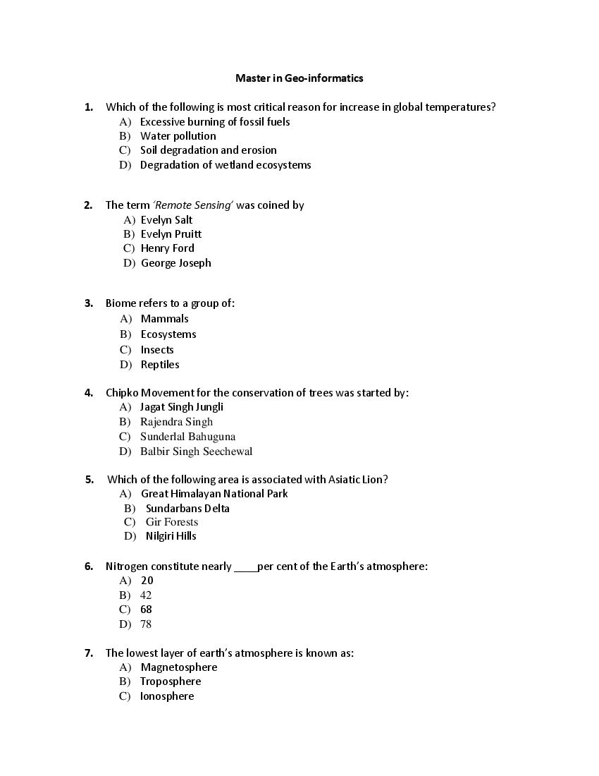
1. Which of the following is most critical reason for increase in global temperatures?
A) Excessive burning of fossil fuels
B) Water pollution
C) Soil degradation and erosion
D) Degradation of wetland ecosystems
2. The term ‘Remote Sensing’ was coined by
A) Evelyn Salt
B) Evelyn Pruitt
C) Henry Ford
D) George Joseph
3. Biome refers to a group of:
A) Mammals
B) Ecosystems
C) Insects
D) Reptiles
4. Chipko Movement for the conservation of trees was started by:
A) Jagat Singh Jungli
B) Rajendra Singh
C) Sunderlal Bahuguna
D) Balbir Singh Seechewal
5. Which of the following area is associated with Asiatic Lion?
A) Great Himalayan National Park
B) Sundarbans Delta
C) Gir Forests
D) Nilgiri Hills
6. Nitrogen constitute nearly ____per cent of the Earth’s atmosphere:
A) 20
B) 42
C) 68
D) 78
7. The lowest layer of earth’s atmosphere is known as:
A) Magnetosphere
B) Troposphere
C) Ionosphere
Page 2
8. Harike wetland and bird sanctuary in Punjab is facing the problem of weed called:
A) Lantana
B) Ageratum
C) Water hyacinth
D) Parthenium
9. Tobacco contains which of the following:
A) Nicotine
B) Caffeine
C) Alcohol
D) Ethene
10. Which of the following is not an Indian satellite
A) Resourcesat
B) Cartosat
C) Oceansat
D) Radarsat
11. Which of the following is Indian satellite
A) LANDSAT
B) RISAT
C) SPOT
D) IKONOS
12. Which one of the following area in India is a designated biodiversity hotspot?
A) Western Ghats
B) Gulf of Mannar
C) Siwalik Hills
D) Western Rajasthan
13. The infamous Bhopal Gas Tragedy occurred in the year:
A) 2004
B) 1980
C) 1984
D) 1961
Page 3
A) Sunderban Deltaic Region
B) Western Ghats
C) Thar Desert
D) Deccan Plateau Region
15. Chlorofluorocarbon (CFC) is mainly generated by:
A) Burning of wood for cooking
B) Refrigeration System
C) Dumping of garbage
D) Burning of waste paper
16. The terms ‘Savanna’ represents:
A) Tropical Grassland
B) Arctic Desert
C) Boreal Forests
D) Australian Desert
17. Indian Institute of Remote Sensing (IIRS) is situated in which Indian City?
A) Delhi
B) Mumbai
C) Dehradun
D) Nainital
18. Which of the following is the largest desert in the world?
A) Gobi Desert
B) Mojabe Desert
C) Kala Hari Desert
D) Sahara Desert
19. Which of the following is not a ‘primary producer’ in an ecosystem?
A) Forest
B) Grassland
C) Fish
D) Phytoplankton
20. A trained and professional map maker is known as:
A) Photographer
B) Cartographer
C) Map Designer
Page 4
21. June 5 is globally celebrated as:
A) World Environment Day
B) World Health Birthday
C) World Population Day
D) World Peace Day
22. Which gas in the atmosphere screens out the harmful radiation from the sun?
A) Neon
B) Carbon
C) Ozone
D) Helium
23. The First type of technology based remote sensing includes:
A) Aerial photographs
B) Landscape Paintings
C) TV remote control systems
D) Sketches by a German Cartographer
24. ‘GAIA’ Theory was propounded by which of the following scholar?
A) Hartshorne
B) James Lovelock
C) Humboldt
D) Derek Gregory
25. Remote Sensing Sensors that detect temperature signature are called:
A) Thermal Infrared Sensor
B) Microwave Sensor
C) Radar Sensing
D) Sonar Sensing
26. Energy from the natural heat produced within the earth is known as:
A) Hydropower
B) Geothermal Energy
C) Tidal Energy
D) Solar Energy
27. Select the non-renewable resource amongst the following:
A) Water
B) Timber
C) Coal
D) Oxygen
Page 5
A) Pesticides
B) No chemical fertilizers and pesticides
C) Insecticides
D) Saline water
29. As per the Government of India, the minimum forest cover necessary to maintain
ecological balance is:
A) 33% of the total land area
B) 45% of the total land area
C) 50% of the total land area
D) 15% of the total land area
30. Microwave Remote Sensing uses which part of electromagnetic spectrum?
A) Short waves
B) Thermal waves
C) Sound waves
D) Very long waves
31. What type of sensing uses Sound waves?
A) Microwave
B) Sonar
C) Infrared
D) Radar
32. Bermuda Triangle is located in:
A) Arctic Ocean
B) Atlantic Ocean
C) Pacific Ocean
D) Indian Ocean
33. Which of the following is the oldest civilization in the world?
A) Indus Valley
B) Mayan
C) Sumerian
D) Inca
34. Which of the following river is called as the sorrow of China:
A) Hwang Ho
B) Amazon
C) Brahmaputra River
Page 6
35. The term GIS refers to?
A) Generic Information System
B) Geographical Information System
C) Generic Intelligent System
D) Geological Intelligent System
36. The famous man-made Palm Islands are located in:
A) Spain
B) Italy
C) Dubai
D) France
37. Cartography is a science and art of:
A) Map Making
B) Computer designing
C) Engine Designing
D) Currency Printing
38. San Andreas fault is located in:
A) Western USA
B) Southern Australia
C) Western Africa
D) Eastern China
39. Which of the following rivers is older than the Himalayan Mountains:
A) River Yamuna
B) River Gandak
C) River Sutlej
D) River Kosi
40. Which one of the following is not an active remote sensor
A) RADAR
B) LIDAR
C) THERMAL SCANNER
D) SAR
41. Which one of the following is a geostationary satellite
A) INSAT
B) IRS
C) QUICKBIRD
D) SPOT
Page 7
A) 0.4-0.5 µm
B) 3.0-5.0 µm
C) 0.4-3.0 µm
D) 10-14 µm
43. What are the two general data formats used in GIS?
A) Digital and Analogue Map
B) Point and Line
C) Raster and Vector
D) Attribute and Feature
44. GIS deals with which kind of data:
A) Numerical data only
B) Binary data only
C) Attribute data only
D) Spatial and attribute data
45. Metadata is:
A) Data about data
B) Geological data
C) Hydrological data
D) Elevation data
46. Which out of the following mountain ranges is known as the Outer Himalayas?
A) Siwalik Range
B) Pir-Panjal Range
C) Zanskar Range
D) Karakoram Range
47. Which of the following is a data collection technique?
A) Editing
B) Analysis
C) Interview
D) Tabulation
48. The output Device of computer system is:
A) Mouse
B) Printer
Page 8
D) Monitor
49. Survey which deals with landed property is called:
A) Topographical Survey
B) Geodetic Survey
C) Ecological Survey
D) Cadastral Survey
50. GPS refers to:
A) Global Positioning System
B) Global Petroleum Survey
C) Global Policy System
D) Global Public System
51. ‘Kangra earthquake’ of 1905 occurred in which Indian state?
A) Himachal Pradesh
B) Jammu and Kashmir
C) Madhya Pradesh
D) Sikkim
52. ‘Spatial database’ is also known as:
A) Tabular databases
B) Binary databases
C) Geodatabase
D) None of the above
53. The arrival of Monsoon in North India takes place in:
A) Late December and early January
B) Early to mid-April
C) Late June and early July
D) Late October and early November
54. Summer Capital of ‘British ruled India’ was:
A) Dehradun
B) Shimla
C) New Delhi
D) Allahabad
55. Which of the following rivers does not flow through Indian Punjab?
A) Beas
Page 9
C) Ravi
D) Kosi
56. Which of the following city of India is known as ‘the City Beautiful’?
A) Kolkata
B) Chennai
C) Chandigarh
D) Delhi
57. Which of the following is a GIS packages?
A) ILWIS
B) ArcGIS
C) Q-GIS
D) All of the above
58. The ‘Disaster Management Cycle’ includes:
A) Disaster Mitigation and Preparedness
B) Disaster Response and Monitoring
C) Disaster Rehabilitation and Reconstruction
D) All of the above
59. Which was the first Indian state to enact the Disaster Management Act in 2003?
A) Punjab
B) Gujarat
C) Maharashtra
D) Madhya Pradesh
60. As the magnitude of an earthquake increases, it’s potential for damage:
A) Increases
B) Decreases
C) Remains the same
D) None of the above
61. The scientific study of earthquakes is known as:
A) Hydrogeology
B) Seismology
C) Entomology
D) Epistemology
62. Which of the following, which is not a natural hazard?
A) Earthquake
B) Tsunami
C) Tropical Cyclone
Page 10
63. The techniques in cartographic by which points on the sphere of the Earth are
transferred to points on the plane surface of a map is known as:
A) Intersection
B) Projection
C) Interpolation
D) Approximation
64. A compass bearing of 155 degrees describes a
A) Northwesterly direction
B) Northeasterly direction
C) Westerly direction
D) Southeasterly direction
65. In which months of a year, northern India receives maximum floods?
A) January-February
B) July-September
C) April-May
D) October-November
66. Lines of latitude are:
A) Diagonal
B) Parallels
C) Meridians
D) None of the above
67. The maximum annual rainfall in India takes place at:
A) Udhampur, Jammu & Kashmir
B) Mawsyngram, Meghalaya
C) Dehradun, Uttarakhand
D) Nagpur, Maharashtra
68. The Radcliffe line is a boundary between
A) India and Nepal
B) India and Bhutan
C) India and Pakistan
D) India and Afghanistan
69. Which Indian state is the only producer of Saffron (Kesar)?
A) Madhya Pradesh
B) West Bengal
Page 11
D) Jammu and Kashmir
70. The oldest mountains in India are:
A) Nilgiri Hills
B) Siwalik Hills
C) Aravalli Hills
D) Karakoram
71. Which of the following Indian States has the maximum percentage of mangrove cover?
A) West Bengal
B) Goa
C) Gujarat
D) Jharkhand
72. The ‘International day for Biodiversity’ is celebrated on:
A) 22 May
B) 15 August
C) 26 January
D) 2 October
73. Greenhouse effect refers to:
A) Ability of atmosphere to retain moisture
B) Ability of atmospheric dust to reflect electromagnetic radiation
C) Ability of atmosphere to form clouds
D) Ability of atmospheric to trap heat and maintain the temperature balance
74. Energy sources that do not increase carbon emissions include:
A) Coal
B) Petroleum
C) Nuclear energy
D) All of the above
75. Which Indian city is the capital of two states?
A) Bhopal
B) Allahabad
C) Ahmedabad
D) Chandigarh
x-x-x
Document Details
| Board / Org | Panjab University |
| Exam | PU CET PG |
| Type | Question Paper |
| Pages | 11 |
| Updated | 22 Jul 2026 |