JNUEE 2021 Question Paper MA Geography
Finished viewing? Save it for later —
Download JNUEE 2021 Question Paper MA Geography (PDF · 21 pages)About JNUEE 2021 Question Paper MA Geography
JNUEE 2021 Question Paper MA Geography is available here for free download. Published by NTA for Jawaharlal Nehru University Entrance Examination, this question paper can be viewed online or downloaded as a PDF (21 pages). Candidates preparing for Jawaharlal Nehru University Entrance Examination can use JNUEE 2021 Question Paper MA Geography to understand the exam pattern, the type of questions asked, and the overall difficulty level.
Frequently Asked Questions
How can I download JNUEE 2021 Question Paper MA Geography?
Open this page and click the Download button to save JNUEE 2021 Question Paper MA Geography as a PDF. It is completely free on AglaSem Docs.
Is JNUEE 2021 Question Paper MA Geography free to download?
Yes. JNUEE 2021 Question Paper MA Geography can be viewed online and downloaded as a PDF free of cost on AglaSem Docs.
How many pages does JNUEE 2021 Question Paper MA Geography have?
JNUEE 2021 Question Paper MA Geography contains 21 pages, which you can read online or download together as a single PDF.
Where can I find more Jawaharlal Nehru University Entrance Examination study material?
You can find more Jawaharlal Nehru University Entrance Examination question papers, sample papers, syllabus, and answer keys on AglaSem Docs.
JNUEE 2021 Question Paper MA Geography – Text
Read the full text of this question paper below — useful to quickly search, copy and reference the content online without downloading the PDF.
📄 View text version (21 pages)
Page 1
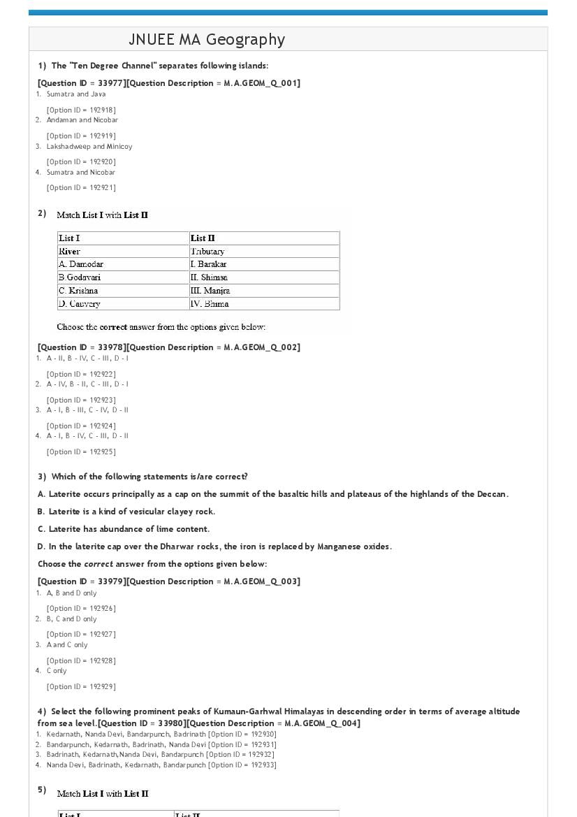
1) The "Ten Degree Channel" separates following islands:
[Question ID = 33977][Question Description = M.A.GEOM_Q_001]
1. Sumatra and Java
[Option ID = 192918]
2. Andaman and Nicobar
[Option ID = 192919]
3. Lakshadweep and Minicoy
[Option ID = 192920]
4. Sumatra and Nicobar
[Option ID = 192921]
2)
[Question ID = 33978][Question Description = M.A.GEOM_Q_002]
1. A ‐ II, B ‐ IV, C ‐ III, D ‐ I
[Option ID = 192922]
2. A ‐ IV, B ‐ II, C ‐ III, D ‐ I
[Option ID = 192923]
3. A ‐ I, B ‐ III, C ‐ IV, D ‐ II
[Option ID = 192924]
4. A ‐ I, B ‐ IV, C ‐ III, D ‐ II
[Option ID = 192925]
3) Which of the following statements is/are correct?
A. Laterite occurs principally as a cap on the summit of the basaltic hills and plateaus of the highlands of the Deccan.
B. Laterite is a kind of vesicular clayey rock.
C. Laterite has abundance of lime content.
D. In the laterite cap over the Dharwar rocks, the iron is replaced by Manganese oxides.
Choose the correct answer from the options given below:
[Question ID = 33979][Question Description = M.A.GEOM_Q_003]
1. A, B and D only
[Option ID = 192926]
2. B, C and D only
[Option ID = 192927]
3. A and C only
[Option ID = 192928]
4. C only
[Option ID = 192929]
4) Select the following prominent peaks of Kumaun‐Garhwal Himalayas in descending order in terms of average altitude
from sea level.[Question ID = 33980][Question Description = M.A.GEOM_Q_004]
1. Kedarnath, Nanda Devi, Bandarpunch, Badrinath [Option ID = 192930]
2. Bandarpunch, Kedarnath, Badrinath, Nanda Devi [Option ID = 192931]
3. Badrinath, Kedarnath,Nanda Devi, Bandarpunch [Option ID = 192932]
4. Nanda Devi, Badrinath, Kedarnath, Bandarpunch [Option ID = 192933]
5)
Page 2
1. A ‐ I, B ‐ II, C ‐ III, D ‐ IV
[Option ID = 192934]
2. A ‐ II, B ‐ III, C ‐ IV, D ‐ I
[Option ID = 192935]
3. A ‐ III, B ‐ IV, C ‐ II, D ‐ I
[Option ID = 192936]
4. A ‐ IV, B ‐ III, C ‐ I, D ‐ II
[Option ID = 192937]
6) Which of these are not Rabi Crops?
A. Rice
B. Wheat
C. Cotton
D. Groundnut
Choose the correct answer from the options given below:
[Question ID = 33982][Question Description = M.A.GEOM_Q_006]
1. A and D only
[Option ID = 192938]
2. B, C and D only
[Option ID = 192939]
3. A, C and D
[Option ID = 192940]
4. A only
[Option ID = 192941]
7) Which of the language given below is not part of Eighth Schedule of Indian Constitution?[Question ID = 33983][Question
Description = M.A.GEOM_Q_007]
1. Konkani [Option ID = 192942]
2. Nepali [Option ID = 192943]
3. Maithili [Option ID = 192944]
4. Bhojpuri [Option ID = 192945]
8) Given below are two statements:
Statement I: Cotton is a subtropical crop.
Statement II: The Temperature shall be below 20 degree celsius for the production of cotton.
In light of the above statements, choose the correct answer from the options given below
[Question ID = 33984][Question Description = M.A.GEOM_Q_008]
1. Both Statement I and Statement II are true
[Option ID = 192946]
2. Both Statement I and Statement II are false
[Option ID = 192947]
3. Statement I is true but Statement II is false
[Option ID = 192948]
4. Statement I is false but Statement II is true
[Option ID = 192949]
9) Given below are two statements
Statement I: Laterite soils are formed through intensive leaching.
Statement II: Laterite soils are very fertile and are of great use for crop production.
In light of the above statements, choose the correct answer from the options given below
Page 3
1. Both Statement I and Statement II are true
[Option ID = 192950]
2. Both Statement I and Statement II are false
[Option ID = 192951]
3. Statement I is true but Statement II is false
[Option ID = 192952]
4. Statement I is false but Statement II is true
[Option ID = 192953]
10)
[Question ID = 33986][Question Description = M.A.GEOM_Q_010]
1. A ‐II, B ‐ IV, C ‐ III, D ‐ I
[Option ID = 192954]
2. A ‐ II, B ‐ III, C ‐ IV, D ‐ I
[Option ID = 192955]
3. A ‐ III, B ‐ I, C ‐ IV, D ‐ II
[Option ID = 192956]
4. A ‐ III, B ‐ IV, C ‐ II, D ‐ I
[Option ID = 192957]
11) Which low‐mountain pass provide passage between Mumabi and Nasik?[Question ID = 33987][Question Description =
M.A.GEOM_Q_011]
1. Thal Ghat [Option ID = 192958]
2. Bhor Ghat [Option ID = 192959]
3. Palghat [Option ID = 192960]
4. Goran Ghat [Option ID = 192961]
12) Consider the following statement with respect to rice cultivation in India:
A. Rice is a tropical plant.
B. Rice requires high heat and high humidity for its sufficient growth.
C. The 100cm isohyet forms the limit of rice in rainfed areas.
D. Rice is a labour intensive crop.
Choose the correct answer from the options given below:
[Question ID = 33988][Question Description = M.A.GEOM_Q_012]
1. A, B and C only
[Option ID = 192962]
2. B, C and D only
[Option ID = 192963]
3. A and D only
[Option ID = 192964]
4. A, B, C and D
[Option ID = 192965]
13) Given below are two statements, one is labelled as Assertion A and the other is labelled as Reason R:
Assertion A: Iron and steel industry in India witnessed rapid growth after independence
Reason R: Development of iron and steel plants was envisaged during the first and second Five Year Plans.
In light of the above statements, choose the most appropriate answer from the options given below
[Question ID = 33989][Question Description = M.A.GEOM_Q_013]
1. Both A and R are correct and R is the correct explanation of A
[Option ID = 192966]
Page 4
[Option ID = 192967]
3. A is correct but R is not correct
[Option ID = 192968]
4. A is not correct but R is correct
[Option ID = 192969]
14)
[Question ID = 33990][Question Description = M.A.GEOM_Q_014]
1. A ‐ I, B ‐ II, C ‐ IV, D ‐ III
[Option ID = 192970]
2. A ‐ I, B ‐ IV, C ‐ II, D ‐ III
[Option ID = 192971]
3. A ‐ III, B ‐ II, C ‐ IV, D ‐ I
[Option ID = 192972]
4. A ‐ III, B ‐ IV, C ‐ II, D ‐ I
[Option ID = 192973]
15) Consider the following statements with respect to jute industry in India:
Statement I: The jute industry in India boomed after the formation of erstwhile East Pakistan (Bangladesh).
Statement II: The jute industry faces very tough competition from synthetic packing materials of the advanced countries.
In light of the above statements, choose the correct answer from the options given below
[Question ID = 33991][Question Description = M.A.GEOM_Q_015]
1. Both Statement I and Statement II are true
[Option ID = 192974]
2. Both Statement I and Statement II are false
[Option ID = 192975]
3. Statement I is true but Statement II is false
[Option ID = 192976]
4. Statement I is false but Statement II is true
[Option ID = 192977]
16) According to Sample Registration System 2018, which state of India has the highest Infant Mortality Rate (IMR)?
[Question ID = 29750][Question Description = M.A.GEOM_Q_016]
1. Uttar Pradesh [Option ID = 192978]
2. Madhya Pradesh [Option ID = 192979]
3. Rajasthan [Option ID = 192980]
4. Orissa [Option ID = 192981]
17) Arrange the following states of India in terms of descending order of density of population (according to Census of India
2011): A. Bihar B. Maharashtra C. Kerala D. Rajasthan Choose the correct answer from the options given below [Question ID
= 29751][Question Description = M.A.GEOM_Q_017]
1. A, B, C, D [Option ID = 192982]
2. A, C, B, D [Option ID = 192983]
3. C, A, D, B [Option ID = 192984]
4. C, B, A, D [Option ID = 192985]
18) Given below are two statements:
Statement I: According to 2011 Census, percentage of urban population to the total population of the country stands at
37.2%.
Statement II: There has been an increase 6 percentage points in the proportion of urban population in the country during
2001‐2011.
In light of the above statements, choose the correct answer from the options given below
Page 5
1. Both Statement I and Statement II are true
[Option ID = 192986]
2. Both Statement I and Statement II are false
[Option ID = 192987]
3. Statement I is true but Statement II is false
[Option ID = 192988]
4. Statement I is false but Statement II is true
[Option ID = 192989]
19) According to Census 2011, which of the following state has witnessed most rapid growth in urban population during
2001‐11?[Question ID = 29753][Question Description = M.A.GEOM_Q_019]
1. Sikkim [Option ID = 192990]
2. Maharashtra [Option ID = 192991]
3. Himachal Pradesh [Option ID = 192992]
4. None of the above [Option ID = 192993]
20) According to Census 2011, which of the following state had the largest number of urban agglomerations?
[Question ID = 29754][Question Description = M.A.GEOM_Q_020]
1. Maharashtra
[Option ID = 192994]
2. Karnataka
[Option ID = 192995]
3. Gujarat
[Option ID = 192996]
4. Uttar Pradesh
[Option ID = 192997]
21) Given below are two statements:
Statement I: Manganese is a non‐ferrous mineral.
Statement II: Chromite and pyrites are ferrous minerals.
In light of the above statements, choose the correct answer from the options given below
[Question ID = 29755][Question Description = M.A.GEOM_Q_021]
1. Both Statement I and Statement II are true
[Option ID = 192998]
2. Both Statement I and Statement II are false
[Option ID = 192999]
3. Statement I is true but Statement II is false
[Option ID = 193000]
4. Statement I is false but Statement II is true
[Option ID = 193001]
22) Given below are two statements, one is labelled as Assertion A and the other is labelled as Reason R
Assertion A: Gujjars and Bakarwals of India practice transhumance.
Reason R: Seasonal variations like extreme cold and absence of grazing grounds at higher altitudes causes migration of
Gujjars and Bakerwals.
In light of the above statements, choose the most appropriate answer from the options given below
[Question ID = 29756][Question Description = M.A.GEOM_Q_022]
1. Both A and R are correct and R is the correct explanation of A
[Option ID = 193002]
2. Both A and R are correct but R is NOT the correct explanation of A
[Option ID = 193003]
3. A is correct but R is not correct
[Option ID = 193004]
4. A is not correct but R is correct
[Option ID = 193005]
23) Given below are two statements, one is labelled as Assertion A and the other is labelled as Reason R
Assertion A: In the Eastern Himalayas, a number of states like Arunachal Pradesh, Nagaland and Mizoram have nucleated
settlements.
Page 6
different traditons and dialects.
In light of the above statements, choose the most appropriate answer from the options given below
[Question ID = 29757][Question Description = M.A.GEOM_Q_023]
1. Both A and R are correct and R is the correct explanation of A
[Option ID = 193006]
2. Both A and R are correct but R is NOT the correct explanation of A
[Option ID = 193007]
3. A is correct but R is not correct
[Option ID = 193008]
4. A is not correct but R is correct
[Option ID = 193009]
24)
[Question ID = 29758][Question Description = M.A.GEOM_Q_024]
1. A ‐ I, B ‐ II, C ‐ IV, D ‐ III
[Option ID = 193010]
2. A ‐ III, B ‐ II, C ‐ IV, D ‐ I
[Option ID = 193011]
3. A ‐ III, B ‐ I, C ‐ IV, D ‐ II
[Option ID = 193012]
4. A ‐ I, B ‐ IV, C ‐ III, D ‐ II
[Option ID = 193013]
25) Given below are two statements:
Statement I: In South India, checker board pattern of rural settlement is quite common in the states of Tamil Nadu,
Karnataka and Andhra Pradesh.
Statement II: The checker board pattern develops at a place where two roads meet at almost right angle.
In light of the above statements, choose the most appropriate answer from the options given below
[Question ID = 29759][Question Description = M.A.GEOM_Q_025]
1. Both Statement I and Statement II are correct
[Option ID = 193014]
2. Both Statement I and Statement II are incorrect
[Option ID = 193015]
3. Statement I is correct but Statement II is incorrect
[Option ID = 193016]
4. Statement I is incorrect but Statement II is correct
[Option ID = 193017]
26) The terms “Kalan” and “Khurd”, used in Indian settlement geography, are a type of:
[Question ID = 29760][Question Description = M.A.GEOM_Q_026]
1. Urban fringe
[Option ID = 193018]
2. City
[Option ID = 193019]
3. Villages
[Option ID = 193020]
4. None of these
[Option ID = 193021]
27) Which one of the following biodiversity hotspot regions of India is the worst ecologically affected?[Question ID = 29761]
[Question Description = M.A.GEOM_Q_027]
Page 7
2. The Indo‐Burma [Option ID = 193023]
3. The Sundalands (including Nicobar group of Islands) [Option ID = 193024]
4. The Western Ghats and Sri Lanka [Option ID = 193025]
28) What is/are the reason for yearly receipt of solar radiation differs at the various latitudes of the earth?
A. The solar input is almost constant at the equator that is about 12 hours per day.
B. While above 66.5⁰ latitude, solar inputs varies from 24 hours per day during winter months.
C. The intensity of solar radiation reaching the surface differs markedly between the equators and poles.
D. The intensity of the light at different latitudes is related to the geometric aspects of the incoming radiation and the
angle at which it hits different earth surfaces.
[Question ID = 29762][Question Description = M.A.GEOM_Q_028]
1. A and B only
[Option ID = 193026]
2. B, C and D only
[Option ID = 193027]
3. A, C and D only
[Option ID = 193028]
4. A, B, C and D
[Option ID = 193029]
29)
[Question ID = 29794][Question Description = M.A.GEOM_Q_029]
1. A ‐ I, B ‐ II, C ‐ III, D ‐ IV
[Option ID = 193314]
2. A ‐ IV, B ‐ II, C ‐ I, D ‐ III
[Option ID = 193315]
3. A ‐ IV, B ‐ II, C ‐ III, D ‐ I
[Option ID = 193316]
4. A ‐ IV, B ‐ III, C ‐ II, D ‐ I
[Option ID = 193317]
30) Who coined the term 'Biome' for the first time?
[Question ID = 29763][Question Description = M.A.GEOM_Q_030]
1. Frederick Clements
[Option ID = 193030]
2. Alexander Von Humboldt
[Option ID = 193031]
3. Charles Darwin
[Option ID = 193032]
4. Ernst Haeckel
[Option ID = 193033]
31) Which of the following statement is not correct?
A. The total accumulated amount of energy stored by the autotrophic primary producers per unit area per unit time is
called ecological productivity.
Page 8
C. Net primary production represents the amount of energy or organic matter fixed or stored at tropic level one.
D. Biomass refers to the quantity or weight of living matter per unit area per unit time and is represented in terms of dry
weight.
Choose the correct answer from the options given below:
[Question ID = 29764][Question Description = M.A.GEOM_Q_031]
1. A only
[Option ID = 193034]
2. B and C only
[Option ID = 193035]
3. C and D only
[Option ID = 193036]
4. A,B,C and D
[Option ID = 193037]
32) If a food chain represents primary producers of very large size (tree) at trophic level 1, and parasites and
hyperparasites at trophic level 2 and 3 as primary and secondary consumers respectively, the resultant pyramid is:
[Question ID = 29765][Question Description = M.A.GEOM_Q_032]
1. Upright
[Option ID = 193038]
2. Inverted
[Option ID = 193039]
3. Spindle shape
[Option ID = 193040]
4. Broad shape and think apex
[Option ID = 193041]
33) Given below are two statements, one is labelled as Assertion A and the other is labelled as Reason R
Assertion A: Carbon dioxide (CO2) is the most abundant of the heat‐trapping greenhouse gases that are increasing due to
human activities.
Reason R: Methane (CH4) and nitrous oxide (N2O) have higher greenhouse‐warming potential per molecule than CO2, and
both are also increasing in the atmosphere.
In light of the above statements, choose the correct answer from the options given below
[Question ID = 29766][Question Description = M.A.GEOM_Q_033]
1. Both A and R are true and R is the correct explanation of A
[Option ID = 193042]
2. Both A and R are true but R is NOT the correct explanation of A
[Option ID = 193043]
3. A is true but R is false
[Option ID = 193044]
4. A is false but R is true
[Option ID = 193045]
34) The grassland often border tropical rain forest. The climate is warm having 100‐150 annual rainfall with the prolonged
dry season in which fires are common and rains are erratic. These Physical and climatic characteristics belong to:
[Question ID = 29767][Question Description = M.A.GEOM_Q_034]
1. Tropical Savana
[Option ID = 193046]
2. Tropical deciduous forest
[Option ID = 193047]
3. Tropical rain forest
[Option ID = 193048]
4. Temperate shrub lands
[Option ID = 193049]
35) Which of the following statement is/are correct as per IPCC sixth assessment report?
A. Over most of the Hindu Kush Himalayan region, snow cover has reduced since the early 21st century and glaciers have
retreated and lost mass since 1970.
B. The Karakoram glacier have remained either in a balanced state or slightly gained mass.
Page 9
D. Snowline elevation in the Hindu Kush will rise and glacier volume will decrease.
Choose the correct answer from the options given below:
[Question ID = 35324][Question Description = M.A.GEOM_Q_035]
1. A, B and C only
[Option ID = 193050]
2. A and B only
[Option ID = 193051]
3. C only
[Option ID = 193052]
4. A, B, C and D
[Option ID = 193053]
36)
[Question ID = 35325][Question Description = M.A.GEOM_Q_036]
1. A ‐ III, B ‐ II, C ‐ IV, D ‐ I [Option ID = 193054]
2. A ‐ IV, B ‐ III, C ‐ II, D ‐ I [Option ID = 193055]
3. A ‐ II, B ‐ III, C ‐ IV, D ‐ I [Option ID = 193056]
4. A ‐ II, B ‐ I, C ‐ IV, D ‐ III [Option ID = 193057]
37) As a river overflows its banks during flood, it drops much of its coarser‐grained load immediately, forming landforms
called _____.[Question ID = 35326][Question Description = M.A.GEOM_Q_037]
1. Alluvial fans [Option ID = 193058]
2. Natural leeves [Option ID = 193059]
3. Deltas [Option ID = 193060]
4. Point bars [Option ID = 193061]
38) Based on particle size, arrange the following in descending order:
A. Gravel
B. Clay
C. Silt
D. Sand
[Question ID = 35327][Question Description = M.A.GEOM_Q_038]
1. A, D, C, B
[Option ID = 193062]
2. C, D, A, B
[Option ID = 193063]
3. A, B, C, D
[Option ID = 193064]
4. D, B, C, A
[Option ID = 193065]
39) Given below are two statements, one is labelled as Assertion A and the other is labelled as Reason R
Assertion A: Medial moraines will not form in the absence of lateral moraines.
Reason R: Terminal moraines are low, narrow, and regularly spaced ridges aligned in the direction of ice movement.
In light of the above statements, choose the correct answer from the options given below
[Question ID = 35328][Question Description = M.A.GEOM_Q_039]
1. Both A and R are true and R is the correct explanation of A
[Option ID = 193066]
Page 10
[Option ID = 193067]
3. A is true but R is false
[Option ID = 193068]
4. A is false but R is true
[Option ID = 193069]
40) Large valleys that are presently occupied by small streams or rivers are called ____.[Question ID = 35329][Question
Description = M.A.GEOM_Q_040]
1. Hanging valleys [Option ID = 193070]
2. Misfit valleys [Option ID = 193071]
3. Two‐story valleys [Option ID = 193072]
4. Valley‐in‐valley [Option ID = 193073]
41) Identify an incorrect statement regarding weathering:
[Question ID = 35330][Question Description = M.A.GEOM_Q_041]
1. The presence of soil slows down the weathering of the underlying bedrock.
[Option ID = 193074]
2. Heat and heavy rainfall increase the rate of chemical weathering.
[Option ID = 193075]
3. The longer a rock is exposed at the surface, the more weathered it becomes.
[Option ID = 193076]
4. Rocks of different compositions weather at different rates.
[Option ID = 193077]
42) The coriolis force is _____.
[Question ID = 35331][Question Description = M.A.GEOM_Q_042]
1. Minimum at the equator
[Option ID = 193078]
2. Maximum at the equator
[Option ID = 193079]
3. Minimum at the poles
[Option ID = 193080]
4. Maximum at 66 and half degree N and S
[Option ID = 193081]
43) What is the correct sequence of processes leading to rainfall?[Question ID = 35332][Question Description =
M.A.GEOM_Q_043]
1. Dew point, precipitation, condensation, unsaturated air [Option ID = 193082]
2. Unsaturated air, dew point, condensation, precipitation [Option ID = 193083]
3. Unsaturated air, condensation, dew point, precipitation [Option ID = 193084]
4. Dew point, condensation, unsaturated air, precipitation [Option ID = 193085]
44) If, at 25 degree Celsius air is saturated when it contains 20 grams of water vapour per kilogram of air. What will be the
relative humidity if the air contains 8 grams of water vapour per kilogram of air?[Question ID = 35333][Question Description
= M.A.GEOM_Q_044]
1. 25% [Option ID = 193086]
2. 35% [Option ID = 193087]
3. 40% [Option ID = 193088]
4. 45% [Option ID = 193089]
45) Given below are two statements, one is labelled as Assertion A and the other is labelled as Reason R
Assertion A: In Southern Hemisphere, winds around high pressure center are counter clockwise.
Reason R: Coriolis force deflects winds to their right in Northern Hemisphere and to their left in Southern Hemisphere.
In light of the above statements, choose the correct answer from the options given below
[Question ID = 35334][Question Description = M.A.GEOM_Q_045]
1. Both A and R are true and R is the correct explanation of A
[Option ID = 193090]
2. Both A and R are true but R is NOT the correct explanation of A
[Option ID = 193091]
3. A is true but R is false
[Option ID = 193092]
4. A is false but R is true
Page 11
46) Amongst the following currents which one is a warm ocean current of Pacific Ocean?[Question ID = 35335][Question
Description = M.A.GEOM_Q_046]
1. Oyashio Current [Option ID = 193094]
2. Kuroshio current [Option ID = 193095]
3. Labrador current [Option ID = 193096]
4. Humboldt current [Option ID = 193097]
47) Considering the following oceans, identify their correct sequence in descending order with respect to the percentage
of area covered by continental shelves of the total area of individual oceans.
A. Pacific Ocean
B. Atlantic Ocean
C. Indian Ocean
Choose the correct answer from the options given below:
[Question ID = 35336][Question Description = M.A.GEOM_Q_047]
1. A, B, C
[Option ID = 193098]
2. C, A, B
[Option ID = 193099]
3. B, C, A
[Option ID = 193100]
4. B, A, C
[Option ID = 193101]
48) Given below are two statements, one is labelled as Assertion A and the other is labelled as Reason R
Assertion A: Dead sea has very low salinity.
Reason R: Dead sea is characterized by internal drainage and is located in tropical wet climate, with high evaporation and
low precipitation.
In light of the above statements, choose the correct answer from the options given below
[Question ID = 35337][Question Description = M.A.GEOM_Q_048]
1. Both A and R are true and R is the correct explanation of A
[Option ID = 193102]
2. Both A and R are true but R is NOT the correct explanation of A
[Option ID = 193103]
3. BothA and R are false
[Option ID = 193104]
4. A is false but R is true
[Option ID = 193105]
49)
[Question ID = 35338][Question Description = M.A.GEOM_Q_049]
1. A ‐ II, B ‐ IV, C ‐ I, D ‐ III
[Option ID = 193106]
2. A ‐ III, B ‐ II, C ‐ I, D ‐ IV
[Option ID = 193107]
3. A ‐ II, B ‐ III, C ‐ I, D ‐ IV
[Option ID = 193108]
4. A ‐ III, B ‐ I, C ‐ IV, D ‐ II
[Option ID = 193109]
50) What is the percentage of Nitrogen in surface ocean water?[Question ID = 35339][Question Description =
Page 12
1. 78.03% [Option ID = 193110]
2. 36.00% [Option ID = 193111]
3. 47.50% [Option ID = 193112]
4. 15.10% [Option ID = 193113]
51) Lysimeter is used to measure ________.[Question ID = 35340][Question Description = M.A.GEOM_Q_051]
1. Evapotranspiration [Option ID = 193114]
2. Evaporation [Option ID = 193115]
3. Vapour Pressure [Option ID = 193116]
4. Infiltration [Option ID = 193117]
52) How much of Earth's water is stored in underground acquifers?[Question ID = 35341][Question Description =
M.A.GEOM_Q_052]
1. About 20% [Option ID = 193118]
2. About 10% [Option ID = 193119]
3. About 5% [Option ID = 193120]
4. Less than 1% [Option ID = 193121]
53) Given below are two statements, one is labelled as Assertion A and the other is labelled as Reason R
Assertion A: Areas downstream of urban areas often experience increased stream flow after major storm event.
Reason R: Urban areas with paved streets and parking lots increase infiltration rate.
In light of the above statements, choose the correct answer from the options given below
[Question ID = 35342][Question Description = M.A.GEOM_Q_053]
1. Both A and R are true and R is the correct explanation of A
[Option ID = 193122]
2. Both A and R are true but R is NOT the correct explanation of A
[Option ID = 193123]
3. A is true but R is false
[Option ID = 193124]
4. A is false but R is true
[Option ID = 193125]
54)
[Question ID = 35343][Question Description = M.A.GEOM_Q_054]
1. A ‐ IV, B ‐ II, C ‐ III, D ‐ I
[Option ID = 193126]
2. A ‐ IV, B ‐ I, C ‐ II, D ‐ III
[Option ID = 193127]
3. A ‐ IV, B ‐ III, C ‐ II, D ‐ I
[Option ID = 193128]
4. A ‐ II, B ‐ I, C ‐ IV, D ‐ III
[Option ID = 193129]
55) What are the three regions in the theory of Heartland?[Question ID = 29768][Question Description =
M.A.GEOM_Q_055]
1. Heartland, Inner Crescent, Outer Crescent [Option ID = 193130]
2. Heartland, Crescent, Inner Crescent [Option ID = 193131]
3. Heartland, Crescent, Outer Crescent [Option ID = 193132]
4. Pivot, Outlying Islands, Continents [Option ID = 193133]
56) Which of the following statements are true?
A) All boundaries are borders.
B) All borders are boundaries.
Page 13
D) All Borders are artificial.
[Question ID = 29769][Question Description = M.A.GEOM_Q_056]
1. A, B and D only
[Option ID = 193134]
2. A, C and E only
[Option ID = 193135]
3. A and D only
[Option ID = 193136]
4. A, B and C only
[Option ID = 193137]
57) Canberra is an example of:
[Question ID = 29770][Question Description = M.A.GEOM_Q_057]
1. Forward Capital City
[Option ID = 193138]
2. Primate City
[Option ID = 193139]
3. New Capital
[Option ID = 193140]
4. Neutral Capital City
[Option ID = 193141]
58) Given below are two statements:
Statement I: Globalization of Environmental Problems has eroded the seeming inviolability of national boundaries.
Statement II: Globalization of Environmental Problems has meant that domestic matters are not transnational issues.
In light of the above statements, choose the correct answer from the options given below
[Question ID = 29771][Question Description = M.A.GEOM_Q_058]
1. Both Statement I and Statement II are true
[Option ID = 193142]
2. Both Statement I and Statement II are false
[Option ID = 193143]
3. Statement I is true but Statement II is false
[Option ID = 193144]
4. Statement I is false but Statement II is true
[Option ID = 193145]
59) Given below are two statements:
Statement I: The concept of Indo‐Pacific is geographically valid.
Statement II: The concept of Indo‐Pacific is a geopolitical construct.
In light of the above statements, choose the most appropriate answer from the options given below
[Question ID = 29772][Question Description = M.A.GEOM_Q_059]
1. Both Statement I and Statement II are correct
[Option ID = 193146]
2. Both Statement I and Statement II are incorrect
[Option ID = 193147]
3. Statement I is correct but Statement II is incorrect
[Option ID = 193148]
4. Statement I is incorrect but Statement II is correct
[Option ID = 193149]
60)
Page 14
1. A ‐ III, B ‐ IV, C ‐ I, D ‐ II
[Option ID = 193150]
2. A ‐ IV, B ‐ III, C ‐ II, D ‐ I
[Option ID = 193151]
3. A ‐ II, B ‐ I, C ‐ V, D ‐ IV
[Option ID = 193152]
4. A ‐ IV, B ‐ II, C ‐ III, D ‐ I
[Option ID = 193153]
61) Who among the following is associated with Geopolitik?
[Question ID = 29774][Question Description = M.A.GEOM_Q_061]
1. Rudolf Kjellen
[Option ID = 193154]
2. Sanjay Chaturvedi
[Option ID = 193155]
3. Karl Haushofer
[Option ID = 193156]
4. Walter Christaller
[Option ID = 193157]
62) What is the extent of 'Territorial Waters' according to the United Nations Convention on the Law of the Sea?
[Question ID = 29775][Question Description = M.A.GEOM_Q_062]
1. 12 Nautical Miles
[Option ID = 193158]
2. 100 Nautical Miles
[Option ID = 193159]
3. 200 Nautical Miles
[Option ID = 193160]
4. 24 Nautical Miles
[Option ID = 193161]
63) In a sample survey, the elderly were asked about their level of pain while walking. The elderly answered in any of the
following responses:
No pain, mild pain, moderate pain, and severe pain. Which of the following variable type is appropriate to assign elderly
responses?
[Question ID = 29776][Question Description = M.A.GEOM_Q_063]
1. Nominal variable
[Option ID = 193162]
2. Ratio scale variable
[Option ID = 193163]
3. Ordinal scale variable
[Option ID = 193164]
4. Interval scale
[Option ID = 193165]
64) In which of the following situations, use of “mean or average” is NOT recommended?[Question ID = 29777][Question
Description = M.A.GEOM_Q_064]
1. When the data series is susceptible to the influence of outliers [Option ID = 193166]
2. When the dataset is discrete [Option ID = 193167]
3. When the data set is continuous [Option ID = 193168]
4. When dataset is very large in size [Option ID = 193169]
65) Which of the following value cannot be a value for Variance?[Question ID = 29778][Question Description =
M.A.GEOM_Q_065]
1. ‐9 [Option ID = 193170]
2. 9 [Option ID = 193171]
3. 0 [Option ID = 193172]
4. 1 [Option ID = 193173]
66) Which of the following is true for Measures of Dispersion?
Page 15
1. Measures of dispersion show the positional values of a series
[Option ID = 193174]
2. Measures of dispersion show the concentration of the data around a central value
[Option ID = 193175]
3. Measures of dispersion show the data are spread out on either side of the center
[Option ID = 193176]
4. None of the above
[Option ID = 193177]
67) The mean of 120, 130, 140, and X is 272.5. What is the value of X?
[Question ID = 29780][Question Description = M.A.GEOM_Q_067]
1. 272.5
[Option ID = 193178]
2. 150
[Option ID = 193179]
3. 120
[Option ID = 193180]
4. 700
[Option ID = 193181]
68) The following are the partition values except:
[Question ID = 29781][Question Description = M.A.GEOM_Q_068]
1. Median
[Option ID = 193182]
2. Percentile
[Option ID = 193183]
3. Decile
[Option ID = 193184]
4. Range
[Option ID = 193185]
69) Which of the following divides the data into four equal parts?
[Question ID = 29782][Question Description = M.A.GEOM_Q_069]
1. Mean
[Option ID = 193186]
2. Range
[Option ID = 193187]
3. Quartile
[Option ID = 193188]
4. Standard Deviation
[Option ID = 193189]
70) Which of the following is a relative measure of dispersion?
[Question ID = 29783][Question Description = M.A.GEOM_Q_070]
1. Range
[Option ID = 193190]
2. Mean deviation from mean
[Option ID = 193191]
3. Coefficient of variation
[Option ID = 193192]
4. Standard deviation
[Option ID = 193193]
71) Which of the following diagram can give mode graphically?
[Question ID = 29784][Question Description = M.A.GEOM_Q_071]
1. Pie chart
[Option ID = 193194]
2. Histogram
[Option ID = 193195]
3. Scatter diagram
Page 16
4. Line diagram
[Option ID = 193197]
72) Arrangement of ungrouped data is needed for computing one the following indicators:
[Question ID = 29785][Question Description = M.A.GEOM_Q_072]
1. Mean
[Option ID = 193198]
2. Median
[Option ID = 193199]
3. Mode
[Option ID = 193200]
4. Standard deviation
[Option ID = 193201]
73) Which of the following data source in India is not widely used for research purposes?[Question ID = 35344][Question
Description = M.A.GEOM_Q_073]
1. Census [Option ID = 193202]
2. Population Registrar [Option ID = 193203]
3. Sample Registration System [Option ID = 193204]
4. NFHS [Option ID = 193205]
74) Who has proposed the “Demographic Transition Theory”?
[Question ID = 35345][Question Description = M.A.GEOM_Q_074]
1. Ansley Coale
[Option ID = 193206]
2. Notestein
[Option ID = 193207]
3. Graunt
[Option ID = 193208]
4. Easterlin
[Option ID = 193209]
75) Which of the following is a major source of migration data in India?[Question ID = 35346][Question Description =
M.A.GEOM_Q_075]
1. Sample Registration System of India [Option ID = 193210]
2. Civil Registration System [Option ID = 193211]
3. Census of India [Option ID = 193212]
4. National Family Health Survey [Option ID = 193213]
76)
[Question ID = 35347][Question Description = M.A.GEOM_Q_076]
1. A ‐ II, B ‐ I, C ‐ IV, D ‐ III
[Option ID = 193214]
2. A ‐ I, B ‐ II, C ‐ IV, D ‐ III
[Option ID = 193215]
3. A ‐ II, B ‐ I, C ‐ III, D ‐ IV
[Option ID = 193216]
4. A ‐ IV, B ‐ I, C ‐ II, D ‐ III
[Option ID = 193217]
77)
Page 17
1. A ‐ II, B ‐ I, C ‐ IV, D ‐ III
[Option ID = 193218]
2. A ‐ I, B ‐ II, C ‐ IV, D ‐ III
[Option ID = 193219]
3. A ‐ III, B ‐ IV, C ‐ II, D ‐ IV
[Option ID = 193220]
4. A ‐ IV, B ‐ I, C ‐ II, D ‐ III
[Option ID = 193221]
78) Which among the following are preventive checks put forth under Malthusian ideas of population growth?
A. Postponement of marriage
B. Celibacy
C. Moral restraint
D. Famines
Choose the correct answer from the options given below:
[Question ID = 35349][Question Description = M.A.GEOM_Q_078]
1. A, B and C only
[Option ID = 193222]
2. B, C and D only
[Option ID = 193223]
3. C, D and A only
[Option ID = 193224]
4. D, A and B only
[Option ID = 193225]
79) Given below are two statements, one is labelled as Assertion A and the other is labeled as Reason R
Assertion A: Elderly population in India usually misreport about their age in census or surveys.
Reason R: Elderly population in India usually does not have their birth certificates.
In light of the above statements, choose the correct answer from the options given below
[Question ID = 35350][Question Description = M.A.GEOM_Q_079]
1. Both A and R are true and R is the correct explanation of A
[Option ID = 193226]
2. BothA and R are true but R is NOT the correct explanation of A
[Option ID = 193227]
3. A is true but R is false
[Option ID = 193228]
4. A is false but R is true
[Option ID = 193229]
80) What is the percent of the elderly population in India as per Census 2011?
[Question ID = 35351][Question Description = M.A.GEOM_Q_080]
1. 5.4 percent
[Option ID = 193230]
2. 8.6 percent
[Option ID = 193231]
3. 12.2 percent
[Option ID = 193232]
4. 16.5 percent
Page 18
81) The basic requirement for a remote sensing sensor system is:
[Question ID = 35352][Question Description = M.A.GEOM_Q_081]
1. Radiometric resolution
[Option ID = 193234]
2. Spectral resolution
[Option ID = 193235]
3. Spatial resolution
[Option ID = 193236]
4. All of the above
[Option ID = 193237]
82) In aerial photography, the standard overlap for a stereo‐pair should be:
[Question ID = 35353][Question Description = M.A.GEOM_Q_082]
1. 20%
[Option ID = 193238]
2. 40%
[Option ID = 193239]
3. 60%
[Option ID = 193240]
4. 80%
[Option ID = 193241]
83) The spectral bands for which the atmosphere is relatively transparent are known as:
[Question ID = 35354][Question Description = M.A.GEOM_Q_083]
1. Atmospheric scattering
[Option ID = 193242]
2. Atmospheric absorption
[Option ID = 193243]
3. Atmospheric constituent
[Option ID = 193244]
4. Atmospheric window
[Option ID = 193245]
84) Which of these Indian Satellite series is in a Geo‐stationery orbit?[Question ID = 35355][Question Description =
M.A.GEOM_Q_084]
1. INSAT [Option ID = 193246]
2. CARTOSAT [Option ID = 193247]
3. RESOURCESAT [Option ID = 193248]
4. All of the above [Option ID = 193249]
85) One of these is not an IRS Sensor:
[Question ID = 35356][Question Description = M.A.GEOM_Q_085]
1. LISS
[Option ID = 193250]
2. TIRS
[Option ID = 193251]
3. PAN
[Option ID = 193252]
4. WiFS
[Option ID = 193253]
86) Spectral Ratioing is a most common technique of:
[Question ID = 35357][Question Description = M.A.GEOM_Q_086]
1. Image Enhancement
[Option ID = 193254]
2. Image Transformation
[Option ID = 193255]
3. Image Correction
[Option ID = 193256]
4. Image Classification
Page 19
87) One of the following element helps in identifying an object on the earth's surface using satellite data.[Question ID =
35358][Question Description = M.A.GEOM_Q_087]
1. Resolution [Option ID = 193258]
2. Signature [Option ID = 193259]
3. Orientation [Option ID = 193260]
4. Aggregation [Option ID = 193261]
88) The stages in a GPS system involve:
I. Generation of an output
II. Detection of the signal
III. In‐built processing of the received data
IV. Decoding of the signal
The correct sequence of the stages is:
[Question ID = 35359][Question Description = M.A.GEOM_Q_088]
1. A ‐ I, B ‐ II, C ‐ III, D ‐ IV
[Option ID = 193262]
2. A ‐ IV, B ‐ III, C ‐ II, D ‐ I
[Option ID = 193263]
3. A ‐ III, B ‐ I, C ‐ II, D ‐ IV
[Option ID = 193264]
4. A ‐ II, B ‐ IV, C ‐ III, D ‐ I
[Option ID = 193265]
89) Buffer is an:
[Question ID = 35360][Question Description = M.A.GEOM_Q_089]
1. Ordered set of data elements or values that are of the same size and type.
[Option ID = 193266]
2. Area on the ground from which EMR is emitted or reflected.
[Option ID = 193267]
3. Enclosed area within a specified distance from a point, line or a polygon.
[Option ID = 193268]
4. Array of equally spaced sample points representing a surface referenced to a common origin.
[Option ID = 193269]
90) Which one of these methods in GIS is best suited for documentation of phenomena and useful to show discrete
features?[Question ID = 35361][Question Description = M.A.GEOM_Q_090]
1. Raster method [Option ID = 193270]
2. Vector method [Option ID = 193271]
3. Grid method [Option ID = 193272]
4. Overlay method [Option ID = 193273]
91) In Climograph given by Griffith Taylor ‘Raw’ represents which type of climatic conditions?
[Question ID = 35362][Question Description = M.A.GEOM_Q_091]
1. Cold and Dry conditions
[Option ID = 193274]
2. Cold and Moist conditions
[Option ID = 193275]
3. Hot and Dry conditions
[Option ID = 193276]
4. Hot and Moist conditions
[Option ID = 193277]
92) Isochronic cartogram represents:[Question ID = 35363][Question Description = M.A.GEOM_Q_092]
1. Speed of travel from a central place of the city to all directions at some definite interval of time [Option ID = 193278]
2. Traffic directions showed by coloured lines [Option ID = 193279]
3. The nature of concentration of traffic [Option ID = 193280]
4. Railway route and passengers carried by them [Option ID = 193281]
93) A map with a R.F. of 1:20,000 is reduced in a ratio of 3:1 and is combined with another map with a R.F. of 1: 18,000
enlarged in a ratio of 3:4. What will be the new R.F. of the combined map?
[Question ID = 29786][Question Description = M.A.GEOM_Q_093]
Page 20
[Option ID = 193282]
2. 1: 30, 000
[Option ID = 193283]
3. 1:40, 000
[Option ID = 193284]
4. 1:60, 000
[Option ID = 193285]
94)
[Question ID = 29787][Question Description = M.A.GEOM_Q_094]
1. A ‐ I, B ‐ II, C ‐ III, D ‐ IV
[Option ID = 193286]
2. A ‐ II, B ‐ IV, C ‐ III, D ‐ I
[Option ID = 193287]
3. A ‐ III, B ‐ I, C ‐ IV, D ‐ II
[Option ID = 193288]
4. A ‐ IV, B ‐ III, C ‐ II, D ‐ I
[Option ID = 193289]
95) Which of the following properties are correct about Bonnies projection?
A. It is an equal area projection.
B. It has more than two standard parallels.
C. The scale along all the parallels are true.
D. It’s parallels are concentric circles.
Choose the correct answer from the options given below:
[Question ID = 29788][Question Description = M.A.GEOM_Q_095]
1. A, B and D only
[Option ID = 193290]
2. A, C and D only
[Option ID = 193291]
3. B, C and D only
[Option ID = 193292]
4. B and D only
[Option ID = 193293]
96) What is the Contour Interval on topsheets with a scale of 1:50,000?[Question ID = 29789][Question Description =
M.A.GEOM_Q_096]
1. 20 Meters [Option ID = 193294]
2. 30 Meters [Option ID = 193295]
3. 50 Meters [Option ID = 193296]
4. 60 Meters [Option ID = 193297]
97) Which of the following pairs is not correctly matched?[Question ID = 29790][Question Description = M.A.GEOM_Q_097]
1. Pantograph ‐ used for the reduction of maps [Option ID = 193298]
2. Rotameter ‐ used for measuring distance within maps [Option ID = 193299]
3. Planimeter ‐ used for measuring areas in maps [Option ID = 193300]
4. Ediograph ‐ used for measuring volumes [Option ID = 193301]
98) With reference to dot method, which of the following statements are correct?
A. Each dot has an identical value
B. It is very effectively used when plotting values in detail on a large scale
C. It is the most convenient method for representing the distribution of absolute figures
Page 21
Choose the correct answer from the options given below:
[Question ID = 29791][Question Description = M.A.GEOM_Q_098]
1. A, B and C only
[Option ID = 193302]
2. A, C and D only
[Option ID = 193303]
3. A, B and D only
[Option ID = 193304]
4. C and D only
[Option ID = 193305]
99) Given below are two statements, one is labelled as Assertion A and the other is labelled as Reason R
Assertion A: Mercator projection is used by the navigators.
Reason R: It is an equal area projection.
In light of the above statements, choose the correct answer from the options given below
[Question ID = 29792][Question Description = M.A.GEOM_Q_099]
1. Both A and R are true and R is the correct explanation of A
[Option ID = 193306]
2. Both A and R are true but R is NOT the correct explanation of A
[Option ID = 193307]
3. A is true but R is false
[Option ID = 193308]
4. A is false but R is true
[Option ID = 193309]
100) Given below are two statements, one is labelled as Assertion A and the other is labelled as Reason R
Assertion A: Vernier scale enables to establish fractions of divisions in both linear and angular measure merits with greater
accuracy.
Reason R: It consists of a moving scale which slides along a primary scale.
In light of the above statements, choose the correct answer from the options given below
[Question ID = 29793][Question Description = M.A.GEOM_Q_100]
1. Both A and R are true and R is the correct explanation of A
[Option ID = 193310]
2. BothA and R are true but R is NOT the correct explanation of A
[Option ID = 193311]
3. A is true but R is false
[Option ID = 193312]
4. A is false but R is true
[Option ID = 193313]
Document Details
| Board / Org | NTA |
| Exam | Jawaharlal Nehru University Entrance Examination |
| Type | Question Paper |
| Pages | 21 |
| Updated | 09 Jun 2026 |