JNUEE 2021 Question Paper Ph.D Political Geography
Finished viewing? Save it for later —
Download JNUEE 2021 Question Paper Ph.D Political Geography (PDF · 12 pages)About JNUEE 2021 Question Paper Ph.D Political Geography
JNUEE 2021 Question Paper Ph.D Political Geography is available here for free download. Published by NTA for Jawaharlal Nehru University Entrance Examination, this question paper can be viewed online or downloaded as a PDF (12 pages). Candidates preparing for Jawaharlal Nehru University Entrance Examination can use JNUEE 2021 Question Paper Ph.D Political Geography to understand the exam pattern, the type of questions asked, and the overall difficulty level.
Frequently Asked Questions
How can I download JNUEE 2021 Question Paper Ph.D Political Geography?
Open this page and click the Download button to save JNUEE 2021 Question Paper Ph.D Political Geography as a PDF. It is completely free on AglaSem Docs.
Is JNUEE 2021 Question Paper Ph.D Political Geography free to download?
Yes. JNUEE 2021 Question Paper Ph.D Political Geography can be viewed online and downloaded as a PDF free of cost on AglaSem Docs.
How many pages does JNUEE 2021 Question Paper Ph.D Political Geography have?
JNUEE 2021 Question Paper Ph.D Political Geography contains 12 pages, which you can read online or download together as a single PDF.
Where can I find more Jawaharlal Nehru University Entrance Examination study material?
You can find more Jawaharlal Nehru University Entrance Examination question papers, sample papers, syllabus, and answer keys on AglaSem Docs.
JNUEE 2021 Question Paper Ph.D Political Geography – Text
Read the full text of this question paper below — useful to quickly search, copy and reference the content online without downloading the PDF.
📄 View text version (12 pages)
Page 1
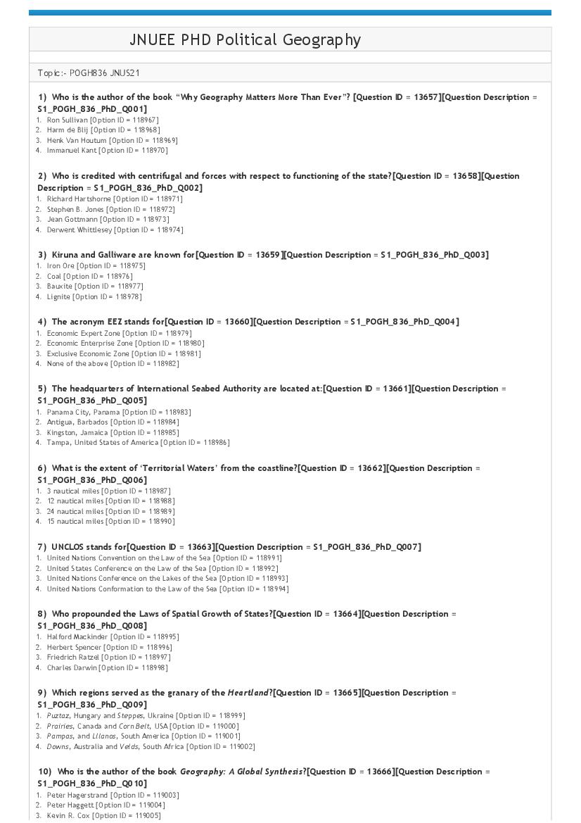
Topic:‐ POGH836 JNUS21
1) Who is the author of the book “Why Geography Matters More Than Ever”? [Question ID = 13657][Question Description =
S1_POGH_836_PhD_Q001]
1. Ron Sullivan [Option ID = 118967]
2. Harm de Blij [Option ID = 118968]
3. Henk Van Houtum [Option ID = 118969]
4. Immanuel Kant [Option ID = 118970]
2) Who is credited with centrifugal and forces with respect to functioning of the state?[Question ID = 13658][Question
Description = S1_POGH_836_PhD_Q002]
1. Richard Hartshorne [Option ID = 118971]
2. Stephen B. Jones [Option ID = 118972]
3. Jean Gottmann [Option ID = 118973]
4. Derwent Whittlesey [Option ID = 118974]
3) Kiruna and Galliware are known for[Question ID = 13659][Question Description = S1_POGH_836_PhD_Q003]
1. Iron Ore [Option ID = 118975]
2. Coal [Option ID = 118976]
3. Bauxite [Option ID = 118977]
4. Lignite [Option ID = 118978]
4) The acronym EEZ stands for[Question ID = 13660][Question Description = S1_POGH_836_PhD_Q004]
1. Economic Expert Zone [Option ID = 118979]
2. Economic Enterprise Zone [Option ID = 118980]
3. Exclusive Economic Zone [Option ID = 118981]
4. None of the above [Option ID = 118982]
5) The headquarters of International Seabed Authority are located at:[Question ID = 13661][Question Description =
S1_POGH_836_PhD_Q005]
1. Panama City, Panama [Option ID = 118983]
2. Antigua, Barbados [Option ID = 118984]
3. Kingston, Jamaica [Option ID = 118985]
4. Tampa, United States of America [Option ID = 118986]
6) What is the extent of ‘Territorial Waters’ from the coastline?[Question ID = 13662][Question Description =
S1_POGH_836_PhD_Q006]
1. 3 nautical miles [Option ID = 118987]
2. 12 nautical miles [Option ID = 118988]
3. 24 nautical miles [Option ID = 118989]
4. 15 nautical miles [Option ID = 118990]
7) UNCLOS stands for[Question ID = 13663][Question Description = S1_POGH_836_PhD_Q007]
1. United Nations Convention on the Law of the Sea [Option ID = 118991]
2. United States Conference on the Law of the Sea [Option ID = 118992]
3. United Nations Conference on the Lakes of the Sea [Option ID = 118993]
4. United Nations Conformation to the Law of the Sea [Option ID = 118994]
8) Who propounded the Laws of Spatial Growth of States?[Question ID = 13664][Question Description =
S1_POGH_836_PhD_Q008]
1. Halford Mackinder [Option ID = 118995]
2. Herbert Spencer [Option ID = 118996]
3. Friedrich Ratzel [Option ID = 118997]
4. Charles Darwin [Option ID = 118998]
9) Which regions served as the granary of the Heartland?[Question ID = 13665][Question Description =
S1_POGH_836_PhD_Q009]
1. Puztaz, Hungary and Steppes, Ukraine [Option ID = 118999]
2. Prairies, Canada and Corn Belt, USA [Option ID = 119000]
3. Pampas, and Lllanos, South America [Option ID = 119001]
4. Downs, Australia and Velds, South Africa [Option ID = 119002]
10) Who is the author of the book Geography: A Global Synthesis?[Question ID = 13666][Question Description =
S1_POGH_836_PhD_Q010]
1. Peter Hagerstrand [Option ID = 119003]
2. Peter Haggett [Option ID = 119004]
3. Kevin R. Cox [Option ID = 119005]
Page 2
11) Indo‐Pacific is a[Question ID = 13667][Question Description = S1_POGH_836_PhD_Q011]
1. Geographical Region [Option ID = 119007]
2. Geopolitical Region [Option ID = 119008]
3. Physiographic Region [Option ID = 119009]
4. Climatic Region [Option ID = 119010]
12) The concept of Heartland signified Mackinder’s purpose to serve the[Question ID = 13668][Question Description =
S1_POGH_836_PhD_Q012]
1. Prussian Empire [Option ID = 119011]
2. Russian Empire [Option ID = 119012]
3. American Supremacy [Option ID = 119013]
4. British Empire [Option ID = 119014]
13) Karl Haushofer is associated with[Question ID = 13669][Question Description = S1_POGH_836_PhD_Q013]
1. Journal of Political Geography [Option ID = 119015]
2. Tidjschrift Voor Economische en Sociale Geografie [Option ID = 119016]
3. Zeitschrift fur Geopolitik [Option ID = 119017]
4. Transactions of the Institute of British Geographers [Option ID = 119018]
14) Who is a critical geographer among the following?[Question ID = 13670][Question Description =
S1_POGH_836_PhD_Q014]
1. Jean Gottmann [Option ID = 119019]
2. Nicholas J. Spykman [Option ID = 119020]
3. David Harvey [Option ID = 119021]
4. Saul B. Cohen [Option ID = 119022]
15) Who is the author of the term “cartographic anxiety”?[Question ID = 13671][Question Description =
S1_POGH_836_PhD_Q015]
1. Sankaran Krishna [Option ID = 119023]
2. P K Rajaram [Option ID = 119024]
3. Arjun Appadurai [Option ID = 119025]
4. H Ramachandran [Option ID = 119026]
16) What do you understand by “Double Peripherality” on Borders?[Question ID = 13672][Question Description =
S1_POGH_836_PhD_Q016]
1. Social and Psychological [Option ID = 119027]
2. Geographical and Political [Option ID = 119028]
3. Cultural and Social [Option ID = 119029]
4. Economic and Geographical [Option ID = 119030]
17) Match the following:
a) Falklands/Las Malvinas i) China‐Philippines
b) Nagorno Karabakh ii) Argentina‐Chile
c) Beagle Channel iii) Armenia‐Azerbaijan
d) Spratly Islands iv) Argentina‐United Kingdom
[Question ID = 13673][Question Description = S1_POGH_836_PhD_Q017]
1. a) ‐ iii), b) –iv, c) – i), d) – ii) [Option ID = 119031]
2. a)‐ iv), b) –i), c)‐ ii), d)‐ iii) [Option ID = 119032]
3. a)‐iv), b) ‐ iii), c‐ ii), d)‐ i) [Option ID = 119033]
4. a)‐iii), b)‐ ii), c)‐ i), d)‐ iv) [Option ID = 119034]
18) Who among the following indicates towards a Territorial Trap with reference to IR theories?[Question ID = 13674]
[Question Description = S1_POGH_836_PhD_Q018]
1. John House [Option ID = 119035]
2. Joe Painter [Option ID = 119036]
3. Paul Routledge [Option ID = 119037]
4. John Agnew [Option ID = 119038]
19) Human Territoriality is[Question ID = 13675][Question Description = S1_POGH_836_PhD_Q019]
1. Instinct [Option ID = 119039]
2. Philosophy [Option ID = 119040]
3. Strategy [Option ID = 119041]
4. Reflex [Option ID = 119042]
20) Under the Land Boundary Agreement (LBA) 2011, India exchanged territory with[Question ID = 13676][Question
Description = S1_POGH_836_PhD_Q020]
1. Bangladesh [Option ID = 119043]
2. Sri Lanka [Option ID = 119044]
3. China [Option ID = 119045]
4. Bhutan [Option ID = 119046]
Page 3
1. Mediterranean Sea and Black Sea [Option ID = 119047]
2. Adriatic Sea and Mediterranean Sea [Option ID = 119048]
3. Mediterranean Sea and Red Sea [Option ID = 119049]
4. Black Sea and Adriatic Sea [Option ID = 119050]
22) The Quadrilateral Dialogue (QUAD) involves[Question ID = 13678][Question Description = S1_POGH_836_PhD_Q022]
1. India, China, Russia and Japan [Option ID = 119051]
2. United States of America, Australia, India and Japan [Option ID = 119052]
3. Australia, China, India, Japan [Option ID = 119053]
4. Russia, United States of America, India and China [Option ID = 119054]
23) What is the correct sequence of regions in terms of development in Immanuel Wallerstein’s World Systems Analysis?
[Question ID = 13679][Question Description = S1_POGH_836_PhD_Q023]
1. Core, Periphery, Semi‐Periphery [Option ID = 119055]
2. Core, Semi‐Periphery, Periphery [Option ID = 119056]
3. Periphery, Core, Semi‐Periphery [Option ID = 119057]
4. Periphery, Semi‐Periphery, Core [Option ID = 119058]
24) Which latitude is the dividing line for the Global North and Global South according to the Willy Brandt Report of 1980?
[Question ID = 13680][Question Description = S1_POGH_836_PhD_Q024]
1. 30° North [Option ID = 119059]
2. 30° South [Option ID = 119060]
3. 35° North [Option ID = 119061]
4. 35° South [Option ID = 119062]
25) Who is attributed with the Theory of Rajamandala?
[Question ID = 13681][Question Description = S1_POGH_836_PhD_Q025]
1. Varaha Mihir
[Option ID = 119063]
2. Yagyavalkya
[Option ID = 119064]
3. Chandragupta Maurya
[Option ID = 119065]
4. Vishnugupt
[Option ID = 119066]
26) Which of the following is the correct sequence in the Unified Field Theory?[Question ID = 13682][Question Description
= S1_POGH_836_PhD_Q026]
1. Political Idea‐Decision‐Movement‐Field‐ Political Area [Option ID = 119067]
2. Movement‐Political Idea‐Decision‐Field‐Political Area [Option ID = 119068]
3. Political Area‐Field‐Political Area‐ Movement‐Decision [Option ID = 119069]
4. Political Idea‐ Movement‐Decision‐Political Area‐Field [Option ID = 119070]
27) . Traditional/Classical Theories of Geopolitics have been criticized on the basis of
a) Privileging the Euro‐centric view of the world
b) Being Hierarchical
c) Not objective
Choose the correct answer from the options given below
[Question ID = 13683][Question Description = S1_POGH_836_PhD_Q027]
1. All of the above [Option ID = 119071]
2. a) and b) [Option ID = 119072]
3. b) and c) [Option ID = 119073]
4. a) and c) [Option ID = 119074]
28) The typology of space as suggested by David Harvey has the following elements
a) Absolute Space
b) Relative Space
c) Relational Space
Choose the correct answer from the options given below:
[Question ID = 13684][Question Description = S1_POGH_836_PhD_Q028]
1. a) and b) [Option ID = 119075]
2. b) and c) [Option ID = 119076]
3. a) and c) [Option ID = 119077]
4. All of the above [Option ID = 119078]
Page 4
a) With infusion of Power
b) With Right to Property
c) With Law of the Land
Choose the correct answer from the options given below:
[Question ID = 13685][Question Description = S1_POGH_836_PhD_Q029]
1. a), b) and c) [Option ID = 119079]
2. a) and c) [Option ID = 119080]
3. b) and c) [Option ID = 119081]
4. a) only [Option ID = 119082]
30) Which of the following statements are true?
a) All boundaries are borders
b) All borders are boundaries
c) All barriers are boundaries
d) All borders are artificial
Choose the correct answer from the options given below
[Question ID = 13686][Question Description = S1_POGH_836_PhD_Q030]
1. a) and b) are true [Option ID = 119083]
2. b) and c) are true [Option ID = 119084]
3. a) and d) are true [Option ID = 119085]
4. c) and d) are true [Option ID = 119086]
31) A majority of international boundaries in Africa are examples of [Question ID = 13687][Question Description =
S1_POGH_836_PhD_Q031]
1. Superimposed Boundary [Option ID = 119087]
2. Antecedent Boundary [Option ID = 119088]
3. Subsequent Boundary [Option ID = 119089]
4. Relict Boundary [Option ID = 119090]
32) Canberra is an example of [Question ID = 13688][Question Description = S1_POGH_836_PhD_Q032]
1. Forward Capital City [Option ID = 119091]
2. Primate City [Option ID = 119092]
3. New Capital [Option ID = 119093]
4. Neutral Capital City [Option ID = 119094]
33) Proponents of Geopolitik based their analyses and interpretation on ideas of [Question ID = 13689][Question Description
= S1_POGH_836_PhD_Q033]
1. Alfred Thayer Mahan [Option ID = 119095]
2. Isaiah Bowman [Option ID = 119096]
3. Halford Mackinder and Friedrich Ratzel [Option ID = 119097]
4. Vidal de la Blache and Walter Christaller [Option ID = 119098]
34) Who is considered responsible for the rehabilitation of the term ‘geopolitics’ during the 1970s and 1980s?[Question ID =
13690][Question Description = S1_POGH_836_PhD_Q034]
1. Samuel Huntington [Option ID = 119099]
2. Robert Kaplan [Option ID = 119100]
3. Henry Kissinger [Option ID = 119101]
4. Julian Minghi [Option ID = 119102]
35) Which of the following provided inspiration to German geopolitical thinkers during the Inter‐War years?[Question ID =
13691][Question Description = S1_POGH_836_PhD_Q035]
1. Lage [Option ID = 119103]
2. Raum [Option ID = 119104]
3. Gesellschaft [Option ID = 119105]
4. Lebensraum [Option ID = 119106]
36) Which of the following are examples of nations without states?[Question ID = 13692][Question Description =
S1_POGH_836_PhD_Q036]
1. Basque, Catalan, Kurds [Option ID = 119107]
2. Basque, Catalan, Iraq [Option ID = 119108]
3. Palestine, Iraq, Kurds [Option ID = 119109]
4. Iraq, Kurds, Catalan [Option ID = 119110]
37) The term “Borderless World” refers to [Question ID = 13693][Question Description = S1_POGH_836_PhD_Q037]
1. Globalization [Option ID = 119111]
2. Privatization [Option ID = 119112]
Page 5
4. Sea Lanes of Communication [Option ID = 119114]
38) Alfred Thayer Mahan’s Sea Power meant[Question ID = 13694][Question Description = S1_POGH_836_PhD_Q038]
1. 1. Naval supremacy [Option ID = 119115]
2. 2. Control of Sea Lanes [Option ID = 119116]
3. 3. Command of the Sea for access to international trade and commerce [Option ID = 119117]
4. 4. Aircraft Carrier [Option ID = 119118]
39) Given below are two statements: one is labelled as Assertion A and the other is labelled as Reason R
Assertion A: There is selective lowering of borders in globalization
Reason R: There is increasing permeability to flows of capital, commodities, information and people
In light of the above statements, choose the most appropriate answer from the options given below:
[Question ID = 13695][Question Description = S1_POGH_836_PhD_Q039]
1. Both A and R are correct and R is the correct explanation of A [Option ID = 119119]
2. Both A and R are correct but R is not the correct explanation of A. [Option ID = 119120]
3. A is correct but R is not correct [Option ID = 119121]
4. A is not correct but R is correct. [Option ID = 119122]
40) Given below are two statements:
Statement I: Globalization of Environmental Problems has eroded the seeming inviolability of national boundaries
Statement II: Globalization of Environmental Problems has meant that domestic matters are not transnational issues.
In the light of the above statements, choose the most appropriate answer from the options given below:
[Question ID = 13696][Question Description = S1_POGH_836_PhD_Q040]
1. Both statement I and statement II are correct [Option ID = 119123]
2. Both statement I and statement II are incorrect [Option ID = 119124]
3. Statement I is correct but statement II is incorrect [Option ID = 119125]
4. Statement I is incorrect but statement II is correct [Option ID = 119126]
41) “Development constructs the contemporary Third World silently, without our noticing it.” The statement can be
attributed to:[Question ID = 13697][Question Description = S1_POGH_836_PhD_Q041]
1. Wolfgang Sachs [Option ID = 119127]
2. Jagdish Bhagwati [Option ID = 119128]
3. Abhijit Banerjee [Option ID = 119129]
4. Arturo Escobar [Option ID = 119130]
42) Stuart Elden’s work “The Birth of Territory” is based on [Question ID = 13698][Question Description =
S1_POGH_836_PhD_Q042]
1. American Historical Experience [Option ID = 119131]
2. European Historical Experience [Option ID = 119132]
3. Asian Historical Experience [Option ID = 119133]
4. African Historical Experience [Option ID = 119134]
43) Friedrich Ratzel’s main concern in his seminal work Politische Geographie was[Question ID = 13699][Question
Description = S1_POGH_836_PhD_Q043]
1. Lack of Overseas Colonies for Germany [Option ID = 119135]
2. Rivalry with United Kingdom [Option ID = 119136]
3. Russia’s Large Area [Option ID = 119137]
4. Rivalry with France [Option ID = 119138]
44) Resurgence of Political Geography as a discipline during the 1970s can be attributed to [Question ID = 13700][Question
Description = S1_POGH_836_PhD_Q044]
1. Positivism [Option ID = 119139]
2. Empiricism [Option ID = 119140]
3. Spatial‐ Quantitative Revolution [Option ID = 119141]
4. Urban Geography [Option ID = 119142]
45) Who among the following sought to find ‘geographical causation in universal history’?[Question ID = 13701][Question
Description = S1_POGH_836_PhD_Q045]
1. Alfred Thayer Mahan [Option ID = 119143]
2. Halford J. Mackinder [Option ID = 119144]
3. Julian S. Corbett [Option ID = 119145]
4. Simon Dalby [Option ID = 119146]
46) Given below are two statements: one is labelled as Assertion A and the other is labelled as Reason R
Assertion A: The State is in continued tension with the phenomenon of globalization.
Page 6
flows of capital and goods between sites in widely scattered locations.
In light of the above statements, choose the most appropriate answer from the options given below:
[Question ID = 13702][Question Description = S1_POGH_836_PhD_Q046]
1. Both A and R are correct and R is the correct explanation of A [Option ID = 119147]
2. Both A and R are correct but R is not the correct explanation of A. [Option ID = 119148]
3. A is correct but R is not correct [Option ID = 119149]
4. A is not correct but R is correct. [Option ID = 119150]
47) Given below are two statements:
Statement I: There is geopolitics to how Environmental Problems are represented.
Statement II: There are multiple geopolitical environmental discourses and multiple geopolitical environmental practices.
In the light of the above statements, chose the most appropriate answer from the options given below:
[Question ID = 13703][Question Description = S1_POGH_836_PhD_Q047]
1. Both statement I and statement II are correct [Option ID = 119151]
2. Both statement I and statement II are incorrect [Option ID = 119152]
3. Statement I is correct but statement II is incorrect [Option ID = 119153]
4. Statement I is incorrect but statement II is correct [Option ID = 119154]
48) The Brundtland Report (WCED, 1987) definition of development is rooted in considerations of [Question ID = 13704]
[Question Description = S1_POGH_836_PhD_Q048]
1. Equality [Option ID = 119155]
2. Equity [Option ID = 119156]
3. Inequality [Option ID = 119157]
4. Uniformity [Option ID = 119158]
49) Geopolitics is about location of resources and its impact on politics. The statement is true for which of the following
resources:[Question ID = 13705][Question Description = S1_POGH_836_PhD_Q049]
1. Oil and Natural Gas [Option ID = 119159]
2. Fisheries [Option ID = 119160]
3. Iron Ore [Option ID = 119161]
4. All of the above [Option ID = 119162]
50) Who are considered to be the founding fathers of modern Political Geography?[Question ID = 13706][Question
Description = S1_POGH_836_PhD_Q050]
1. Alfred Thayer Mahan, Nicholas J. Spykman, Halford J. Mackinder [Option ID = 119163]
2. Friedrich Ratzel, Halford J. Mackinder, Isaiah Bowman [Option ID = 119164]
3. Karl Haushofer, Walter Christaller, Isaiah Bowman [Option ID = 119165]
4. Alfred Thayer Mahan, Jean Gottmann, Richard Hartshorne [Option ID = 119166]
51) What are the basic research goals?
A. Exploration
B. Description
C. Explanation
D. Evaluation
E. Generalization
Choose the correct answer from the options given below:
[Question ID = 13707][Question Description = S1_POGH_836_PhD_Q051]
1. B, C, D, E [Option ID = 119167]
2. B, C, D, A [Option ID = 119168]
3. A, B, C, E [Option ID = 119169]
4. A, C, D, E [Option ID = 119170]
52) Replication is seen as a safeguard against:[Question ID = 13708][Question Description = S1_POGH_836_PhD_Q052]
1. Drawing informed conclusions about the world [Option ID = 119171]
2. Drawing premature and therefore possibly false conclusions [Option ID = 119172]
3. Discovering truth [Option ID = 119173]
4. None of the above [Option ID = 119174]
53) Given below are two statements: one is labelled as Assertion A and the other is labelled as Reason R
Assertion A: The nomothetic path adopts a generalist or a “macro” approach to causal analysis.
Reason R: The nomothetic mode; tries to identify a few key factors that explain the most about our dependent variable
In light of the above statements, choose the most appropriate answer from the options given below:
Page 7
1. Both A and R are correct and R is the correct explanation of A [Option ID = 119175]
2. Both A and R are correct but R is not the correct explanation of A. [Option ID = 119176]
3. A is correct but R is not correct [Option ID = 119177]
4. A is not correct but R is correct. [Option ID = 119178]
54) What is common for traditional knowledge, authoritative knowledge, common sense and intuition?[Question ID = 13710]
[Question Description = S1_POGH_836_PhD_Q054]
1. Encouragement of an uncritical acceptance of information [Option ID = 119179]
2. Encouragement of critical acceptance of information [Option ID = 119180]
3. Critical questioning of knowledge [Option ID = 119181]
4. Confirmation of information [Option ID = 119182]
55) Which of the following is not an example of a cohort?[Question ID = 13711][Question Description =
S1_POGH_836_PhD_Q055]
1. Common birth periods [Option ID = 119183]
2. Same year graduation [Option ID = 119184]
3. Same period of military service [Option ID = 119185]
4. Members of a Poker club [Option ID = 119186]
56) Map scales represented by means of a line or linear graphs of various kinds are known as [Question ID = 13712]
[Question Description = S1_POGH_836_PhD_Q056]
1. Statement Scale [Option ID = 119187]
2. Vernier Scale [Option ID = 119188]
3. Representative Fraction [Option ID = 119189]
4. Graphic Scale [Option ID = 119190]
57) Given below are two statements:
Statement I: All maps are inherently political
Statement II: Maps reflect the socio‐spatial situation of the cartographer.
In the light of the above statements, chose the most appropriate answer from the options given below:
[Question ID = 13713][Question Description = S1_POGH_836_PhD_Q057]
1. Both statement I and statement II are correct [Option ID = 119191]
2. Both statement I and statement II are incorrect [Option ID = 119192]
3. Statement I is correct but statement II is incorrect [Option ID = 119193]
4. Statement I is incorrect but statement II is correct [Option ID = 119194]
58) Given below are two statements: one is labelled as Assertion A and the other is labelled as Reason R
Assertion A: Map Projection is a method by which the curved surface of the earth is represented on a flat plane
Reason R: The operational process involves dimensional transformation i.e. a 2‐dimensional representation of the 3‐
dimensional figure of the earth.
In light of the above statements, choose the most appropriate answer from the options given below:
[Question ID = 13714][Question Description = S1_POGH_836_PhD_Q058]
1. Both A and R are correct and R is the correct explanation of A [Option ID = 119195]
2. A is not correct but R is correct. [Option ID = 119196]
3. Both A and R are correct but R is not the correct explanation of A. [Option ID = 119197]
4. A is correct but R is not [Option ID = 119198]
59) An imaginary line joining places with equal elevation above sea level is known as [Question ID = 13715][Question
Description = S1_POGH_836_PhD_Q059]
1. Grid [Option ID = 119199]
2. Contour [Option ID = 119200]
3. Bar Line [Option ID = 119201]
4. Line [Option ID = 119202]
60) Which of the following is a suitable projection for countries with nearly equal latitudinal and longitudinal extensions, for
example, Netherlands, France, Switzerland, and India?
[Question ID = 13716][Question Description = S1_POGH_836_PhD_Q060]
1. Cylindrical Projection
[Option ID = 119203]
2. Planar Projection
[Option ID = 119204]
3. Mercator’s Projection
[Option ID = 119205]
4. Bonne’s Projection
[Option ID = 119206]
Page 8
1. Jordan Branch [Option ID = 119207]
2. Thongchai Winichakul [Option ID = 119208]
3. Mark Monmonier [Option ID = 119209]
4. Robert Kaplan [Option ID = 119210]
62) Who authored the book For a Geography of Power?[Question ID = 13718][Question Description =
S1_POGH_836_PhD_Q062]
1. Claude Raffestin [Option ID = 119211]
2. Michael Foucault [Option ID = 119212]
3. Claudio Minca [Option ID = 119213]
4. Derek Gregory [Option ID = 119214]
63) Who is credited with the concept of ‘cartographic reduction’?[Question ID = 13719][Question Description =
S1_POGH_836_PhD_Q063]
1. Brian Harley [Option ID = 119215]
2. Franco Farinelli [Option ID = 119216]
3. J.H. Andrews [Option ID = 119217]
4. Dennis Cosgrove [Option ID = 119218]
64) An exhaustive listing of all the elements that make up a research population is known as [Question ID = 13720]
[Question Description = S1_POGH_836_PhD_Q064]
1. Systematic Random Sampling [Option ID = 119219]
2. Random Sampling [Option ID = 119220]
3. Sampling Frame [Option ID = 119221]
4. Cluster Sampling [Option ID = 119222]
65) What is raw data?
[Question ID = 13721][Question Description = S1_POGH_836_PhD_Q065]
1. a body of information in numerical form
[Option ID = 119223]
2. unclassified data
[Option ID = 119224]
3. Facts and figures
[Option ID = 119225]
4. Sequentially arranged data
[Option ID = 119226]
66) What are the two types of maps based on objectivity and purpose?[Question ID = 13722][Question Description =
S1_POGH_836_PhD_Q066]
1. Small scale and Large scale [Option ID = 119227]
2. Atlas map and Cadastral Map [Option ID = 119228]
3. Topographic and Thematic [Option ID = 119229]
4. Medium Scale and Large Scale [Option ID = 119230]
67) The process of identifying and gathering data from various sources in a wide range of methods and formats is known as
[Question ID = 13723][Question Description = S1_POGH_836_PhD_Q067]
1. Data Acquisition [Option ID = 119231]
2. Data Collection [Option ID = 119232]
3. Manipulation [Option ID = 119233]
4. Data Management [Option ID = 119234]
68) Organization of the sampling frame into relatively homogenous groups before selecting elements for the sample is
[Question ID = 13724][Question Description = S1_POGH_836_PhD_Q068]
1. Cluster Sampling
[Option ID = 119235]
2. Systematic Random Sampling
[Option ID = 119236]
3. Stratified Sampling
[Option ID = 119237]
4. Random Sampling
[Option ID = 119238]
69) Which of the following is the more personal form of survey research?[Question ID = 13725][Question Description =
S1_POGH_836_PhD_Q069]
1. Interview [Option ID = 119239]
2. Questionnaire [Option ID = 119240]
3. Electronic Mail [Option ID = 119241]
Page 9
70) Small scale maps are useful in the depiction of large areas like[Question ID = 13726][Question Description =
S1_POGH_836_PhD_Q070]
1. Atlas Map [Option ID = 119243]
2. Settlement Plans [Option ID = 119244]
3. Topographic Sheets [Option ID = 119245]
4. Cadastral Map [Option ID = 119246]
71) In the data matrix, each column gives the value of a specific property or characteristic that varies from an individual to
another. They are called:[Question ID = 13727][Question Description = S1_POGH_836_PhD_Q071]
1. Variables [Option ID = 119247]
2. Units [Option ID = 119248]
3. Pair [Option ID = 119249]
4. Class [Option ID = 119250]
72) An arrangement of data in which all items are placed sequentially in order of magnitude is known as [Question ID =
13728][Question Description = S1_POGH_836_PhD_Q072]
1. Class Limit [Option ID = 119251]
2. Variable [Option ID = 119252]
3. Array [Option ID = 119253]
4. Sample [Option ID = 119254]
73) Primary data concerns:[Question ID = 13729][Question Description = S1_POGH_836_PhD_Q073]
1. The firsthand information collected in the field [Option ID = 119255]
2. The secondhand information collected from the extra‐field sources [Option ID = 119256]
3. Choice of the sample [Option ID = 119257]
4. Postulating hypothesis [Option ID = 119258]
74) The base of GIS is formed by[Question ID = 13730][Question Description = S1_POGH_836_PhD_Q074]
1. Hydrography [Option ID = 119259]
2. Cartography [Option ID = 119260]
3. Cosmology [Option ID = 119261]
4. Creativity [Option ID = 119262]
75) Ethnography means[Question ID = 13731][Question Description = S1_POGH_836_PhD_Q075]
1. Writing about life [Option ID = 119263]
2. Writing about race [Option ID = 119264]
3. Writing about people [Option ID = 119265]
4. Writing about identity [Option ID = 119266]
76) In GIS, all data can be represented with:[Question ID = 13732][Question Description = S1_POGH_836_PhD_Q076]
1. Rectangle, triangle, scale [Option ID = 119267]
2. Point, line, polygon [Option ID = 119268]
3. Scale, north, legend [Option ID = 119269]
4. Point, north, scale [Option ID = 119270]
77) Causality is defined as the relation between:
[Question ID = 13733][Question Description = S1_POGH_836_PhD_Q077]
1. Causa and Ratio
[Option ID = 119271]
2. Rationality and Intent
[Option ID = 119272]
3. Mind and cause
[Option ID = 119273]
4. Cause and Effect
[Option ID = 119274]
78) Which among the following is not a component of Research Proposal?[Question ID = 13734][Question Description =
S1_POGH_836_PhD_Q078]
1. Literature Review [Option ID = 119275]
2. Hypothesis [Option ID = 119276]
3. Rationale [Option ID = 119277]
4. Conclusion [Option ID = 119278]
79) Which among the following is not a measure of Central Tendency?[Question ID = 13735][Question Description =
S1_POGH_836_PhD_Q079]
1. Mean [Option ID = 119279]
2. Median [Option ID = 119280]
3. Mode [Option ID = 119281]
4. Range [Option ID = 119282]
Page 10
S1_POGH_836_PhD_Q080]
1. Professionalism [Option ID = 119283]
2. Respect for other presenters [Option ID = 119284]
3. Preparation [Option ID = 119285]
4. All of the above [Option ID = 119286]
81) “Measurement can be an immensely powerful weapon in the battle between two theories”. The statement can be
attributed to:[Question ID = 13737][Question Description = S1_POGH_836_PhD_Q081]
1. Imre Lakatos [Option ID = 119287]
2. Thomas Kuhn [Option ID = 119288]
3. Karl Popper [Option ID = 119289]
4. Steven Pincker [Option ID = 119290]
82) What does the acronym SPSS stand for?[Question ID = 13738][Question Description = S1_POGH_836_PhD_Q082]
1. Statistical Package for Social Sciences [Option ID = 119291]
2. Sample Package for Social Sciences [Option ID = 119292]
3. Statistical Package for Social Studies [Option ID = 119293]
4. Smart Package for Social Sciences [Option ID = 119294]
83) Which of the following is credited with developing the first GIS system?[Question ID = 13739][Question Description =
S1_POGH_836_PhD_Q083]
1. United States Public Health Service [Option ID = 119295]
2. United State Forest Service [Option ID = 119296]
3. Canada GIS [Option ID = 119297]
4. Mexico GIS [Option ID = 119298]
84) Manipulation and Analysis of data is known as [Question ID = 13740][Question Description = S1_POGH_836_PhD_Q084]
1. Georeferencing [Option ID = 119299]
2. Geofencing [Option ID = 119300]
3. Geoprocessing [Option ID = 119301]
4. Geosophy [Option ID = 119302]
85) Database can be thought of as [Question ID = 13741][Question Description = S1_POGH_836_PhD_Q085]
1. Collection of data files linked logically [Option ID = 119303]
2. Collection of data [Option ID = 119304]
3. Retrieval of Data [Option ID = 119305]
4. Processing Data [Option ID = 119306]
86) Nominal data divides responses into categories, which are[Question ID = 13742][Question Description =
S1_POGH_836_PhD_Q086]
1. Inclusive [Option ID = 119307]
2. Mutually exclusive [Option ID = 119308]
3. Classified [Option ID = 119309]
4. Binary [Option ID = 119310]
87) Given below are two statements:
Statement I: Topographic maps depict as much of the surface features of a particular area as is possible within the limitation
of the scale.
Statement II: They are multipurpose as they portray the spatial association of diverse geographical phenomena.
In the light of the above statements, chose the most appropriate answer from the options given below:
[Question ID = 13743][Question Description = S1_POGH_836_PhD_Q087]
1. Both statement I and statement II are correct [Option ID = 119311]
2. Both statement I and statement II are incorrect [Option ID = 119312]
3. Statement I is correct but statement II is incorrect. [Option ID = 119313]
4. Statement I is incorrect but statement II is correct [Option ID = 119314]
88) Which one of the following is not a group of worlds suggested by Karl Popper?[Question ID = 13744][Question
Description = S1_POGH_836_PhD_Q088]
1. The physical world [Option ID = 119315]
2. The world of mental states and subjective knowledge [Option ID = 119316]
3. The material world [Option ID = 119317]
4. The world of social and recorded knowledge [Option ID = 119318]
89) The process of grouping the objects, facts or events in respect to their relations with each other and properties
determined as results of observation is known as [Question ID = 13745][Question Description = S1_POGH_836_PhD_Q089]
1. Classification [Option ID = 119319]
2. Manipulation [Option ID = 119320]
Page 11
4. Application [Option ID = 119322]
90) Positive or negative conditions which the events, facts or objects had over time can be called as[Question ID = 13746]
[Question Description = S1_POGH_836_PhD_Q090]
1. Metamorphosis [Option ID = 119323]
2. Transformation [Option ID = 119324]
3. Change [Option ID = 119325]
4. Information [Option ID = 119326]
91) What is an abstract?[Question ID = 13747][Question Description = S1_POGH_836_PhD_Q091]
1. Introduction of the research project [Option ID = 119327]
2. Summary of the research project [Option ID = 119328]
3. Methodology of the research project [Option ID = 119329]
4. Result of the research project [Option ID = 119330]
92) What is the purpose of deception in research?[Question ID = 13748][Question Description = S1_POGH_836_PhD_Q092]
1. To get participants to reveal their true thoughts [Option ID = 119331]
2. To hide information [Option ID = 119332]
3. To steal information [Option ID = 119333]
4. To convey feelings [Option ID = 119334]
93) In non‐random sampling:[Question ID = 13749][Question Description = S1_POGH_836_PhD_Q093]
1. Participants are selected based on characteristics they possess or their availability to participate [Option ID = 119335]
2. Participants are randomly selected [Option ID = 119336]
3. Participants are classified according to age [Option ID = 119337]
4. Participants are selected from different regions [Option ID = 119338]
94) The document that describes the planned research process is called[Question ID = 13750][Question Description =
S1_POGH_836_PhD_Q094]
1. Report [Option ID = 119339]
2. Essay [Option ID = 119340]
3. Dissertation [Option ID = 119341]
4. Research Proposal [Option ID = 119342]
95) Given below are two statements: one is labelled as Assertion A and the other is labelled as Reason R
Assertion A: Social Science by its nature is a probabilistic endeavor
Reason R: We do not have 100% certainty in social science.
In light of the above statements, choose the most appropriate answer from the options given below:
[Question ID = 13751][Question Description = S1_POGH_836_PhD_Q095]
1. Both A and R are correct and R is the correct explanation of A [Option ID = 119343]
2. A is not correct but R is correct. [Option ID = 119344]
3. Both A and R are correct but R is not the correct explanation of A. [Option ID = 119345]
4. A is correct but R is not. [Option ID = 119346]
96) Which one of the following is correctly arranged in Saul B. Cohen’s interpretation of the world system?[Question ID =
13752][Question Description = S1_POGH_836_PhD_Q096]
1. Geopolitical Region, Geostrategic Realm, Nation‐State [Option ID = 119347]
2. Nation‐State, Geostrategic Realm, Geopolitical region [Option ID = 119348]
3. Shatterbelt, Geopolitical Region, Gateway [Option ID = 119349]
4. Geostrategic Realm, Geopolitical Region, Nation‐State [Option ID = 119350]
97) Who is the author of the book Territory, State and Society?[Question ID = 13753][Question Description =
S1_POGH_836_PhD_Q097]
1. Stanley D. Brunn [Option ID = 119351]
2. Oscar Martinez [Option ID = 119352]
3. Kevin R. Cox [Option ID = 119353]
4. Anssi Paasi [Option ID = 119354]
98) Which of the following countries has multiple Core Areas?[Question ID = 13754][Question Description =
S1_POGH_836_PhD_Q098]
1. France [Option ID = 119355]
2. Russia [Option ID = 119356]
3. Hungary [Option ID = 119357]
4. India [Option ID = 119358]
99) Herodote is a journal from the [Question ID = 13755][Question Description = S1_POGH_836_PhD_Q099]
1. German Geopolitical Tradition [Option ID = 119359]
2. French Geopolitical Tradition [Option ID = 119360]
3. American Geopolitical Tradition [Option ID = 119361]
Page 12
100) Which of the following elements of state is explicitly Geographical in nature?[Question ID = 13756][Question
Description = S1_POGH_836_PhD_Q100]
1. Government [Option ID = 119363]
2. Sovereignty [Option ID = 119364]
3. Recognition [Option ID = 119365]
4. Territory [Option ID = 119366]
Document Details
| Board / Org | NTA |
| Exam | Jawaharlal Nehru University Entrance Examination |
| Type | Question Paper |
| Pages | 12 |
| Updated | 22 Jul 2026 |