JNUEE 2021 Question Paper Ph.D Regional Development Geography
Finished viewing? Save it for later —
Download JNUEE 2021 Question Paper Ph.D Regional Development Geography (PDF · 22 pages)About JNUEE 2021 Question Paper Ph.D Regional Development Geography
JNUEE 2021 Question Paper Ph.D Regional Development Geography is available here for free download. Published by NTA for Jawaharlal Nehru University Entrance Examination, this question paper can be viewed online or downloaded as a PDF (22 pages). Candidates preparing for Jawaharlal Nehru University Entrance Examination can use JNUEE 2021 Question Paper Ph.D Regional Development Geography to understand the exam pattern, the type of questions asked, and the overall difficulty level.
Frequently Asked Questions
How can I download JNUEE 2021 Question Paper Ph.D Regional Development Geography?
Open this page and click the Download button to save JNUEE 2021 Question Paper Ph.D Regional Development Geography as a PDF. It is completely free on AglaSem Docs.
Is JNUEE 2021 Question Paper Ph.D Regional Development Geography free to download?
Yes. JNUEE 2021 Question Paper Ph.D Regional Development Geography can be viewed online and downloaded as a PDF free of cost on AglaSem Docs.
How many pages does JNUEE 2021 Question Paper Ph.D Regional Development Geography have?
JNUEE 2021 Question Paper Ph.D Regional Development Geography contains 22 pages, which you can read online or download together as a single PDF.
Where can I find more Jawaharlal Nehru University Entrance Examination study material?
You can find more Jawaharlal Nehru University Entrance Examination question papers, sample papers, syllabus, and answer keys on AglaSem Docs.
JNUEE 2021 Question Paper Ph.D Regional Development Geography – Text
Read the full text of this question paper below — useful to quickly search, copy and reference the content online without downloading the PDF.
📄 View text version (22 pages)
Page 1
1) The remote sensing primarily based on the electromagnetic energy radiation (EMR) comes from the Sun. The remote sensing system records EMR based
on the basic physics principles as follows:
A. Wave theory
B. Particle theory
C. Stefan‐Boltzmann law
D. Wien’s displacement law
Choose the correct answer “Albert Einstein (1879‐1955) resolved that ‘light interacts with matter, … which carry particle‐like properties as energy and
momentum’ ” from the options given below:[Question ID = 35214][Question Description = GEOH_Q_001]
1. A, B and C only [Option ID = 208325]
2. B only [Option ID = 208326]
3. B, C and D only [Option ID = 208327]
4. A only [Option ID = 208328]
2) The air temperature of 86‐degree Fahrenheit may be converted to their degree Celsius equivalents. Choose the correct answer from the options given
below:[Question ID = 35215][Question Description = GEOH_Q_002]
1. 32 degree Celsius [Option ID = 208329]
2. 30 degree Celsius [Option ID = 208330]
3. 33 degree Celsius [Option ID = 208331]
4. 31 degree Celsius [Option ID = 208332]
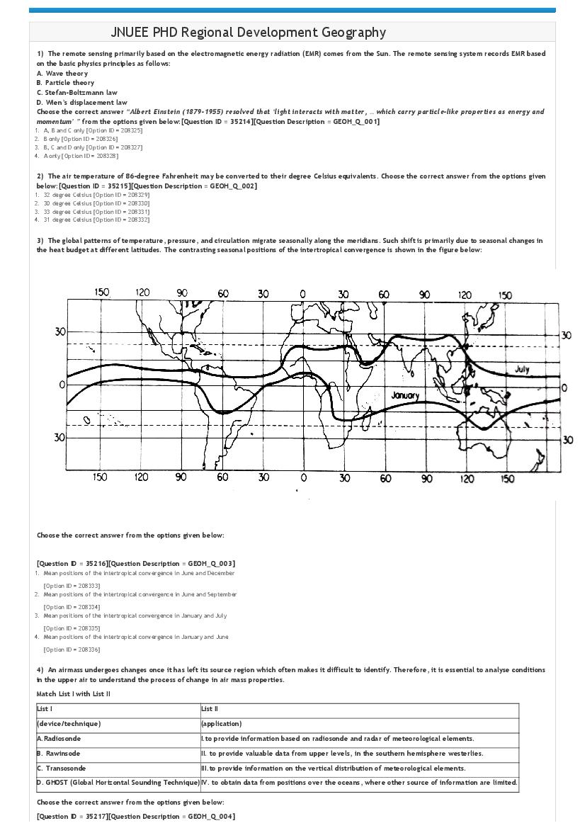
3) The global patterns of temperature, pressure, and circulation migrate seasonally along the meridians. Such shift is primarily due to seasonal changes in
the heat budget at different latitudes. The contrasting seasonal positions of the intertropical convergence is shown in the figure below:
[Question ID = 35216][Question Description = GEOH_Q_003]
1. Mean positions of the intertropical convergence in June and December
[Option ID = 208333]
2. Mean positions of the intertropical convergence in June and September
[Option ID = 208334]
3. Mean positions of the intertropical convergence in January and July
[Option ID = 208335]
4. Mean positions of the intertropical convergence in January and June
[Option ID = 208336]
4) An airmass undergoes changes once it has left its source region which often makes it difficult to identify. Therefore, it is essential to analyse conditions
in the upper air to understand the process of change in air mass properties.
Match List I with List II
List I List II
(device/technique) (application)
A.Radiosonde I.to provide information based on radiosonde and radar of meteorological elements.
B. Rawinsode II. to provide valuable data from upper levels, in the southern hemisphere westerlies.
C. Transosonde III.to provide information on the vertical distribution of meteorological elements.
D. GHOST (Global Horizontal Sounding Technique)IV. to obtain data from positions over the oceans, where other source of information are limited.
[Question ID = 35217][Question Description = GEOH_Q_004]
Page 2
2. A ‐ II, B ‐ IV, C ‐ III, D ‐ I [Option ID = 208338]
3. A ‐ III, B ‐ I, C ‐ IV, D ‐ II [Option ID = 208339]
4. A ‐ I, B ‐ III, C ‐ II, D ‐ IV [Option ID = 208340]
5) The Extratropical cyclones originate between the prevailing westerlies and the polar easterlies which is a more or less permanent, undulating baroclinic
zone. The stages of development and occlusion of an extratropical cyclone along the polar front in the Northern Hemisphere schematically drawn below:
Choose the correct answer from the options given below
[Question ID = 35218][Question Description = GEOH_Q_005]
1. A ‐ beginning of cyclonic circulation; B ‐ warm sector well defined between fronts; C ‐ initial stage; D ‐ dissipation; E ‐ cold front overtaking warm front; F ‐ occlusion.
[Option ID = 208341]
2. A ‐ initial stage; B ‐ beginning of cyclonic circulation; C ‐ warm sector well defined between fronts; D ‐ cold front overtaking warm front; E ‐ occlusion; F ‐ dissipation.
[Option ID = 208342]
3. A ‐ warm sector well defined between fronts; B ‐ initial stage; C ‐ cold front overtaking warm front; D ‐ beginning of cyclonic circulation; E ‐ dissipation; F ‐ occlusion.
[Option ID = 208343]
4. A ‐ warm sector well defined between fronts; B ‐ beginning of cyclonic circulation; C ‐ initial stage; D ‐ occlusion; E ‐ dissipation; F ‐ cold front overtaking warm front.
[Option ID = 208344]
6) The planet earth studies fall into broad categories as follows:
A. Lithosphere
B. Hydrosphere
C. Atmosphere
D. Biosphere
E. Cryosphere
Choose the correct answer for the study of water from the options given below:E12[Question ID = 35219][Question Description = GEOH_Q_006]
1. A and B only [Option ID = 208345]
2. B and D only [Option ID = 208346]
3. C and E only [Option ID = 208347]
4. B and E only [Option ID = 208348]
7) The aerial photograph contains a feature of two road intersections which was easily locatable on topographic sheet of 1:25,000 scale. The measure
distance between intersections was 47.2 mm on the topographic map and 94.3 mm on the aerial photograph. What was the scale of the aerial photograph?
[Question ID = 35220][Question Description = GEOH_Q_007]
1. 1: 14,500 [Option ID = 208349]
2. 1: 15,500 [Option ID = 208350]
3. 1: 12,500 [Option ID = 208351]
4. 1: 13,500 [Option ID = 208352]
8) Soil is a layer of earth material which undergoes continuous change and development over time. There are many factors which influence the formation
of soils.
A. Climate
B. Plant and animal life
C. Relief
D. Parent material
Page 3
Choose the correct answer of natural factors of soil formation from the options given below:[Question ID = 35221][Question Description = GEOH_Q_008]
1. B, C, A and D only [Option ID = 208353]
2. A, E, C and B only [Option ID = 208354]
3. A, C, D and E only [Option ID = 208355]
4. A, B, C, D and E [Option ID = 208356]
9) The Coronavirus disease vaccines use in individuals 18 years of age and older for prevention of (Covid‐19) were approved for emergency use by the
Ministry of Health and Family Welfare, Govt. of India.
Match List I with List II
List I List II
(vaccines) (manufacturer/Developer)
I. University of Oxford, with British pharmaceutical major AstraZeneca,
A. Covaxin
Oxford, England.
B.
II. Bharat Biotech in collaboration with Indian Council of Medical
Covishield
Research.
III. United States National Institute of Allergy and Infectious Diseases
C. Sputnik
(NIAID) and Biomedical Advanced Research and Development Authority
V
(BARDA).
D.
IV. Gamaleya, Moscow Institute, Russia.
Moderna
[Question ID = 35222][Question Description = GEOH_Q_009]
1. A ‐ II, B ‐ I, C ‐ IV, D ‐ III
[Option ID = 208357]
2. A ‐ I, B ‐ IV, C ‐ III, D ‐ II
[Option ID = 208358]
3. A ‐ III, B ‐ II, C ‐ IV, D ‐ I
[Option ID = 208359]
4. A ‐ IV, B ‐ II, C ‐ I, D ‐ III
[Option ID = 208360]
10) Given below are two statements, one is labelled as Assertion Aand the other islabelled as Reason R
Assertion A:Once the protective cover of natural vegetation and the organic matter in the topsoil are reduced, a rapid rate of erosion proceeds to occur
phenomenally.
Reason R:Cultural practices in land use have all too seldom provided for a compensating acceleration in soil forming processes.
In light of the above statements, choose the most appropriate answer from the options given below:
[Question ID = 35223][Question Description = GEOH_Q_010]
1. Both Aand R are true and R is the correct explanation of A
[Option ID = 208361]
2. Both Aand R are true butR is NOT the correct explanation of A
[Option ID = 208362]
3. A is true but R is false
[Option ID = 208363]
4. A is false but R is true
[Option ID = 208364]
11) A vertical aerial photograph on a scale of 1: 7,500 showed an area of a lake measured 52.2 cm2. What was the area of lake at ground level?[Question
ID = 35224][Question Description = GEOH_Q_011]
1. 2,93,625 m2
[Option ID = 208365]
2. 2,83,625 m2
[Option ID = 208366]
3. 2,63,625 m2
[Option ID = 208367]
4. 2,73,625 m2
[Option ID = 208368]
12) The Indian Peninsula never subsided under the sea permanently in Earth’s geologic history. It’s origin of rocks dating back to more than 3600 million
years ago. Some of major rock systems are mentioned below:
A. Dharwar system
B. Cuddapah system
C. Gondwana system
D. Tertiary system
Choose the correct answer of rocks of Precambrian period and Holocene epoch from the options given below:[Question ID = 35225][Question Description =
GEOH_Q_012]
1. A, C and D only [Option ID = 208369]
2. A, B, C and D [Option ID = 208370]
3. B, C and D only [Option ID = 208371]
4. C, D and A only [Option ID = 208372]
13) For multi‐spectral or multi‐layer images, algebraic operations, logarithms, exponentials, and trigonometric functions are applied to the DNs of
different bands for each pixel to produce a new image, operations are as follows:
Match List I with List II
Page 4
(operations) (explanations)
A. Image
I. Image processing performed pixel by pixel; at each image pixel.
addition
B. Image II. Image processing produces a weighted summation of two or more
differencing images.
C. Image III. Image processing performed to carry out image division for
multiplication selective spectral features enhancement.
IV. Image processing produces a difference image from two image
D. Image ratio
inputs.
[Question ID = 35226][Question Description = GEOH_Q_013]
1. A ‐ II, B ‐ IV, C ‐ I, D ‐ III [Option ID = 208373]
2. A ‐ III, B ‐ II, C ‐ IV, D ‐ I [Option ID = 208374]
3. A ‐ I, B ‐ III, C ‐ II, D ‐ IV [Option ID = 208375]
4. A ‐ IV, B ‐ I, C ‐ III, D ‐ II [Option ID = 208376]
14) Weather changes especially the temperature extremes are most commonly influence the human health which causes of illness arising from direct
effects of atmospheric conditions on the body as given below:
A. Hyperthermia
B. Heat exhaustion
C. Heat cramps
D. Hypothermia
Choose the correct answer of high temperature extremes from the options given below: [Question ID = 33685][Question Description = GEOH_Q_014]
1. B, A and C only [Option ID = 208377]
2. B, C and D only [Option ID = 208378]
3. A, B, C and D [Option ID = 208379]
4. D, C and A only [Option ID = 208380]
15) The atmospheric pollution consisted by an undesirable concentration of any phenomena in the air that may affect human health and comfort.
Given below are two statements:
Statement I: “the kinds of atmospheric pollution are gases, liquids, pollens and organic dust, heat, light, noise, turbulence, and radioactivity”.
Statement II: “the kinds of chemical pollutants are sulphur dioxide, carbon modoxide, nitrogen oxides, zone and various hydrocarbons”.
In light of the above statements, choose the most appropriate answer from the options given below [Question ID = 33686][Question Description =
GEOH_Q_015]
1. Both Statement I and Statement II are correct [Option ID = 208381]
2. Both Statement I and Statement II are incorrect [Option ID = 208382]
3. Statement I is correct but Statement II is incorrect [Option ID = 208383]
4. Statement I is incorrect but Statement II is correct [Option ID = 208384]
16) Earth surface terrain mapping requires precise network of meridians and parallels. Exact lengths of degrees of latitude and longitude are specified on
the basis of dimensions of the earth ellipsoid.
Match List I with List II
List I List II
(ellipsoid sets) (computed by/for region)
A. International ellipsoid of I. General Clarke, Ordnance Survey, for central
1909 Africa.
II. J.F. Hayford, US Coast and Geodetic Survey, for
B. Clarke ellipsoid of 1866
Europe.
III. Sir George Everest, Surveyor General India, for
C.Clarke ellipsoid of 1880
India.
IV. A.R. Clarke, English Ordnance Survey, for North
D. Everest ellipsoid of 1830
America.
[Question ID = 33687][Question Description = GEOH_Q_016]
1. A ‐ I, B ‐ II, C ‐ IV, D ‐ III [Option ID = 208385]
2. A ‐ II, B ‐ IV, C ‐ I, D ‐ III [Option ID = 208386]
3. A ‐ III, B ‐ I, C ‐ IV, D ‐ II [Option ID = 208387]
4. A ‐ IV, B ‐ III, C ‐ II, D ‐ I [Option ID = 208388]
17) The North Atlantic Ocean's certain typical features of the ocean basin and the continental margins are mentioned below:
A. Continental margin
B. Ocean basin floor
C. Mid‐oceanic ridge
D. Continental shelf
Choose the correct answer of second‐order relief features of the ocean basins from the options given below:[Question ID = 33688][Question Description =
GEOH_Q_017]
1. B, C, A and D [Option ID = 208389]
2. C, B and A only [Option ID = 208390]
3. B, C and D only [Option ID = 208391]
4. C, D and A only [Option ID = 208392]
18) The Landforms systematic study according to their origin and stage of development was introduced by geomorphologist of the Harward University,
about 1890. Choose the correct answer from the options given below:[Question ID = 33689][Question Description = GEOH_Q_018]
1. Richard Chorley [Option ID = 208393]
2. David Leslie Linton [Option ID = 208394]
3. William Morris Davis [Option ID = 208395]
4. David Ross Stoddart [Option ID = 208396]
Page 5
submits down to valley bottoms.
A. Mountain slopes
B. Hill slopes
C. Valley‐side slopes
D. Soil‐covered slopes
Choose the correct answer from the options given below:[Question ID = 33690][Question Description = GEOH_Q_019]
1. A, B and C only [Option ID = 208397]
2. B, C, A and D [Option ID = 208398]
3. A, B and D only [Option ID = 208399]
4. B, C and D only [Option ID = 208400]
20) The processes of the physical and chemical weathering affecting rocks are given below. Which one is a process of small‐scale exfoliation of igneous
rocks as basalt called spheroidal weathering?[Question ID = 33691][Question Description = GEOH_Q_020]
1. Oxidation [Option ID = 208401]
2. Hydrolysis [Option ID = 208402]
3. Carbonic [Option ID = 208403]
4. Slaking [Option ID = 208404]
21) Research is a cautious and thorough investigation of a phenomenon with an objective of advancing knowledge in the light of new findings.
Match List I with List II
List I List II
(types) (description)
A. Empirical I. Research carried out and based on study of different periods of
research history.
B. Historical II. Research encompasses observation of facts or interactions dealing
research with people.
C. Social III. Research based on building of knowledge through collection of
research empirically verifiable evidences.
D. Scientific IV. Research focusses on the study of human groups and their
research interactions.
[Question ID = 33692][Question Description = GEOH_Q_021]
1. A ‐ I, B ‐ III, C ‐ IV, D ‐ II [Option ID = 208405]
2. A ‐ II, B ‐ IV, C ‐ III, D ‐ I [Option ID = 208406]
3. A ‐ II, B ‐ I, C ‐ IV, D ‐ III [Option ID = 208407]
4. A ‐ I, B ‐ II, C ‐ III, D ‐ IV [Option ID = 208408]
22) There are many types of scientific research, some of them mentioned below. Which one is the qualitative research used in formulating and testing of
hypotheses and theories?[Question ID = 33693][Question Description = GEOH_Q_022]
1. Descriptive research [Option ID = 208409]
2. Exploratory research [Option ID = 208410]
3. Explanatory research [Option ID = 208411]
4. Retrospective research [Option ID = 208412]
23) The types of samplings are as the probability and the non‐probability of which some of the forms are mentioned below:
A. Cluster samping
B. Purposive sampling
C. Snowball sampling
D. Systematic sampling
Choose the correct answer of non‐probability sampling from the options given below:[Question ID = 33694][Question Description = GEOH_Q_023]
1. A, C and D only [Option ID = 208413]
2. A and D only [Option ID = 208414]
3. B, C and D only [Option ID = 208415]
4. B and C only [Option ID = 208416]
24) There are different types of scale used in research which determine form of the statistical analysis. Some of the appropriate descriptive statistics for
different types of scales are listed below:
Match List I with List II
List I List II
(statistics) (scale/description)
A. Mode I. Ordinal – a scale provides rank ordered from lowest to highest.
II. Nominal – a scale used for counting of the most sophisticated form
B. Median
of statistical analysis.
III. Ratio/interval – a scale may be calculated when true interval
C. Mean
scale data are obtained.
D. Geometric IV. Interval – a scale allows investigators to compare differences
mean between scale values.
Choose the correct most appropriate answer from the options given below:
[Question ID = 33695][Question Description = GEOH_Q_024]
1. A ‐ II, B ‐ I, C ‐ IV, D ‐ III [Option ID = 208417]
2. A ‐ I, B ‐ II, C ‐ III, D ‐ IV [Option ID = 208418]
3. A ‐ III, B ‐ IV, C ‐ I, D ‐ II [Option ID = 208419]
4. A ‐ IV, B ‐ II, C ‐ III, D ‐ I [Option ID = 208420]
25) In case the research is not based on quantitative measure then there is a need for assessing validity to invoke concepts in a qualitative way. The
researcher must ask themselves the very important epistemological question of validity when designing research of which kinds are mentioned below:
A. Internal validity
Page 6
C. Ecological validity
D. External validity
Choose the correct answer of validity concepts specific to time, sample or context from the options given below:
[Question ID = 33696][Question Description = GEOH_Q_025]
1. A, B and C only
[Option ID = 208421]
2. B, C and D only
[Option ID = 208422]
3. A, B, C and D
[Option ID = 208423]
4. C, D and A only
[Option ID = 208424]
26) Match List I with List II
List I List II
(geographers) (contributions)
A. Halford
I. “unity in geographical diversity but rested his regional
Mackinder (1861‐
synthesis more directly on a teleological foundation”.
1974)
B. Carl Ritter II. “unity of organic life, … organismic analogy, in the direction
(1779‐1859) of geopolitics of the state”.
C. Alexander von III. “conveniently of independent means, who searched for the
Humbolt (1769‐ universal patterns underlying particular, observed
1859) phenomena”.
D. Friedrich Ratzel IV. “synthesized natural and cultural geography to provide the
(1844‐1904) naturalistic basis for … foreign policy”.
[Question ID = 33697][Question Description = GEOH_Q_026]
1. A ‐ IV, B ‐ I, C ‐ III, D ‐ II [Option ID = 208425]
2. A ‐ I, B ‐ II, C ‐ IV, D ‐ III [Option ID = 208426]
3. A ‐ III, B ‐ II, C ‐ IV, D ‐ I [Option ID = 208427]
4. A ‐ II, B ‐ III, C ‐ I, D ‐ IV [Option ID = 208428]
27) Match List I with List II
List I List II
(author) (contribution)
A. J.H. Von
I. The distribution of industry in space.
Thunen, 1966
B. Alfred Weber, II. The distribution of cities size… idealised as a hexagonal,
1929 hierarchical structure.
C. Walter III. The best location is far more dignified than determination
Christaller, 1933 of the actual one.
D. August Losch,
IV. The distribution of agricultural land uses around cities.
1954
[Question ID = 33698][Question Description = GEOH_Q_027]
1. A ‐ I, B ‐ III, C ‐ II, D ‐ IV [Option ID = 208429]
2. A ‐ II, B ‐ III, C ‐ IV, D ‐ I [Option ID = 208430]
3. A ‐ IV, B ‐ I, C ‐ II, D ‐ III [Option ID = 208431]
4. A ‐ III, B ‐ IV, C ‐ I, D ‐ II [Option ID = 208432]
28) The drainage pattern refers to a design/arrangment which a river and its tributaries form together, from its source to its mouth.
Match List I with List II
List I List II
(drainage patterns) (rivers/regions)
A. Drainage pattern 'A'I. The Arun river (Nepal), a tributary of the Koshi river.
B. Drainage pattern 'B' II. Old folded mountains of Singhbum (Chotanagpur plateau).
C. Drainage pattern 'C' III. Vindhyan mountains of peninsular India.
D. Drainage pattern 'D'IV. Most of the Rivers of the Indo‐Gangetic Plains.
Page 7
1. A ‐ IV, B ‐ II, C ‐ I, D ‐ III
[Option ID = 208433]
2. A ‐ II, B ‐ IV, C ‐ III, D ‐ I
[Option ID = 208434]
3. A ‐ I, B ‐ III, C ‐ IV, D ‐ II
[Option ID = 208435]
4. A ‐ III, B ‐ I, C ‐ II, D ‐ IV
[Option ID = 208436]
29) The River regimes of the Himalayan and the Peninsular rivers discharge in cumecs (cubic meters per second) graphics/ figures presented below:
Page 8
Statement I:The Ganga River at Farakka and Jhelum River at Baramulla Gorge maximum volume of discharge occurs in July or August. The rivers thus have
typical monsoonal regime.
Statement II:The Narmada River at Garudoshwar and Godavari River at Valaporammaximum volume of discharge occurs January to July and until May,
respectively.
In light of the above statements, choose the most appropriate answer from the options given below
[Question ID = 33700][Question Description = GEOH_Q_029]
1. Both Statement I and Statement II are correct
[Option ID = 208437]
2. Both Statement I and Statement II are incorrect
[Option ID = 208438]
3. Statement I is correct but Statement II is incorrect
[Option ID = 208439]
4. Statement I is incorrect but Statement II is correct
[Option ID = 208440]
30) How to improve the spatial resolution of a 30‐m resolution TM colour composite imagery with a 10‐m resolution SPOT panchromatic imagery using RGB‐
IHS transformation?
A. Rectify the low‐resolution colour composite image (TM image) to the high‐resolution image of the same scene (SPOT panchromatic image).
B. Perform the RGB‐IHS transformation on the low‐resolution colour composite image.
C. Replace the intensity component, I, by the high‐resolution image.
D. Perform the reverse IHS‐RGB transformation.
Choose the correct answer of Image Fusion Technique – RGB‐IHS transformation from the options given below:
[Question ID = 33701][Question Description = GEOH_Q_030]
1. B, C and A only [Option ID = 208441]
2. A, B, C and D [Option ID = 208442]
3. C, D and A only [Option ID = 208443]
4. B, A and C only [Option ID = 208444]
31) The tropical monsoon type of climate often stated for India.
Given below are two statements:
Statement I:Climatic classification based on (i) mean monthly temperature; (ii) mean monthly rainfall; and (iii) mean annual rainfall produced broad
climatic zones as Humid (A), Arid (B), Semi‐arid (C & D).
Statement II:Climatic classification based on 18°C isotherm of mean temperature for January produced two broad climatic regions as (i) the subtropical or
continental zone to north of this isotherm; and (ii) tropical zone to south of this isotherm, produced broad climatic divisions as (A) Subtropical climate, (B)
Tropical climate.
In light of the above statements, choose the most appropriate answer from the options given below:
[Question ID = 33702][Question Description = GEOH_Q_031]
1. Both Statement I and Statement II are correct [Option ID = 208445]
2. Both Statement I and Statement II are incorrect [Option ID = 208446]
3. Statement I is correct but Statement II is incorrect [Option ID = 208447]
4. Statement I is incorrect but Statement II is correct [Option ID = 208448]
32) Image pixels can be classified by the multi‐variable statistical classification or segmentation techniques. The dissimilarity functions formulate decision
rules for both supervised and unsupervised classification algorithms, commonly used are given below:
A. Box classifier
B. Euclidean distance
C. Maximum likelihood
D. Optimal multipoint reassignment
Choose the correct answer of decision rule based on Bayes’ theorem from the options given below:[Question ID = 33703][Question Description =
GEOH_Q_032]
1. A, C and D only [Option ID = 208449]
2. C only [Option ID = 208450]
Page 9
4. B only [Option ID = 208452]
33) The Montane wet temperate forests found spread at an altitude ranging of 1500 m to 3500 m where the temperature varies 12‐15 degree Celsius
and the mean annual rainfall ranges 100‐250 cm in the Himalayas.
Match List I with List II
List I List II
(tree species) (scientific name)
A. Deobar tree specie I. Abies alba
B. Magnolia tree specie II. Cedrus Deodara
C. Cedar tree specie III. Chiamaecyparis
D. Silver‐fir tree specie IV. Magnolia glandifora
[Question ID = 35227][Question Description = GEOH_Q_033]
1. A ‐ II, B ‐ I, C ‐ III, D ‐ IV [Option ID = 208453]
2. A ‐ I, B ‐ IV, C ‐ II, D ‐ III [Option ID = 208454]
3. A ‐ II, B ‐ IV, C ‐ III, D ‐ I [Option ID = 208455]
4. A ‐ IV, B ‐ II, C ‐ I, D ‐ III [Option ID = 208456]
34) What kind of remote sensing data is required for the applications areas as the precision agriculture, crop yield investigations, traffic studies and
emergency response?[Question ID = 35228][Question Description = GEOH_Q_034]
1. High spatial and temporal resolution remote sensing data. [Option ID = 208457]
2. Low spatial and temporal resolution remote sensing data. [Option ID = 208458]
3. Nominal spatial and temporal resolution remote sensing data. [Option ID = 208459]
4. Nominal radiometric and geometric corrected remote sensing data. [Option ID = 208460]
35) Soil erosion caused to remove top soil which is a widely prevailing phenomenon in India. About 180 million hectares affected by different agents’ of
soil erosion as shown in the Figure below:
Match List I with List II
List I List II
(soil erosion areas, based on above map index)(types of erosion)
A. Shade 'A' I. Gully cum sheet erosion
B.Shade 'B' II. Desert erosion (Aeolian)
C.Shade 'C' III. Sheet erosion
Page 10
[Question ID = 35229][Question Description = GEOH_Q_035]
1. A ‐ I, B ‐ III, C ‐ II, D ‐ IV
[Option ID = 208461]
2. A ‐ II, B ‐ I, C ‐ IV, D ‐ III
[Option ID = 208462]
3. A ‐ IV, B ‐ I, C ‐ III, D ‐ II
[Option ID = 208463]
4. A ‐ III, B ‐ IV, C ‐ I, D ‐ II
[Option ID = 208464]
36) Which of the image classification approaches have a usages of an iterative classification method of the followings?
A. Unsupervised classification
B. Supervised classification
C. Hybrid classification
D. Image scanning classification
Choose the correct answer from the options given below:[Question ID = 35230][Question Description = GEOH_Q_036]
1. A and B only [Option ID = 208465]
2. B, C and D only [Option ID = 208466]
3. A, B and C only [Option ID = 208467]
4. C and D only [Option ID = 208468]
37) Indian economy is called gamble of monsoon. A large proportion of population about 58.20 per cent is dependent on agriculture.
Given below are two statements:
Statement I: “it is the agriculture sector that the battle for long term economic development will be won or lost”, Gunnar Myrdal
Statement II: “in case agriculture goes wrong, nothing else will have a chance to go right”, M.S. Swaminathan
In light of the above statements, choose the most appropriate answer from the options given below
[Question ID = 35231][Question Description = GEOH_Q_037]
1. Both Statement I and Statement II are correct
[Option ID = 208469]
2. Both Statement I and Statement II are incorrect
[Option ID = 208470]
3. Statement I is correct but Statement II is incorrect
[Option ID = 208471]
4. Statement I is incorrect but Statement II is correct
[Option ID = 208472]
38) The Land tenure and Land tenancy, regulate the ownership of agricultural land, on the one hand and these are the institutional factors which
collectively have their impact on level of agricultural development. Given below are two statements:
Statement I: The Land tenure and Land tenancy, regulate the ownership of agricultural land, which were deregulated during British period, and new
system as Zamindari, Mahalwari and Royatwari implemented to collect land revenue.
Statement II: The institutional factors field size, field patterns, farming type, cropping patten and association, and productivity, including above,
collectively have their no impact on level of agricultural development.
In light of the above statements, choose the most appropriate answer from the options given below
[Question ID = 35232][Question Description = GEOH_Q_038]
1. Both Statement I and Statement II are correct
[Option ID = 208473]
2. Both Statement I and Statement II are incorrect
[Option ID = 208474]
3. Statement I is correct but Statement II is incorrect
[Option ID = 208475]
4. Statement I is incorrect but Statement II is correct
[Option ID = 208476]
39) Liberalisation open avenues to the foreign entrepreneurs to accelerate industrial growth and socio‐economic development under programmes of the
Central and State governments.
Given below are two statements, one is labelled as Assertion Aand the other islabelled as Reason R
Assertion A:“the liberalisation opened the economy to direct foreign investment with 51 per cent equity, and started with the process of reducing
government subsidies”.
Reason R:“disinvestment of shares of public undertakings to reduce government share holding to 51 per cent which will improve efficiency of public
sector as the efficient and prompt decision‐making process”.
In light of the above statements, choose the most appropriateanswer from the options given below:
[Question ID = 35233][Question Description = GEOH_Q_039]
1. BothAand R are correct and R is the correct explanation of A
[Option ID = 208477]
2. BothAand R are correct butR is NOT the correct explanation of A
[Option ID = 208478]
3. A is correct but R is not correct
[Option ID = 208479]
4. A is not correct but R is correct
[Option ID = 208480]
40) Demographic transition model shows a transition from a stable population with high mortality and fertility to stable population with low mortality and
fertility.
Page 11
List I List II
(demographic phases ‐ see
(explanation)
above figure)
A. Phase I I. Steady growth of population
B. Phase II II. Stagnant growth of population
III. High growth with sign of slow decline of
C. Phase III
population
D. Phase IV IV. Rapid growth of population
[Question ID = 35234][Question Description = GEOH_Q_040]
1. A ‐ II, B ‐ I, C ‐ IV, D ‐ III
[Option ID = 208481]
2. A ‐ III, B ‐ IV, C ‐ I, D ‐ II
[Option ID = 208482]
3. A ‐ I, B ‐ III, C ‐ II, D ‐ IV
[Option ID = 208483]
4. A ‐ IV, B ‐ II, C ‐ III, D ‐ I
[Option ID = 208484]
41) There are two statistical distributions drawn on the two graphs, i.e. Graph 1 and Graph 2, given below:
Page 12
B. Graph 2: Same mean, same standard deviations
C. Graph 1: Same standard deviation, different means
D. Graph 2: Same standard deviations, same means
[Question ID = 35235][Question Description = GEOH_Q_041]
1. A and C only
[Option ID = 208485]
2. B and D only
[Option ID = 208486]
3. A and B only
[Option ID = 208487]
4. C and D only
[Option ID = 208488]
42) The Hypothesis testing is the process of determining whether a hypothesis is supported by the results of a research project.
Match List I with List II
List I List II
(concept) (description)
A. Null I. An alternative hypothesis stating that a difference is expected
Hypothesis between the groups, and it is expected to occur in a specific direction.
B.
II. The hypothesis stating that the independent variables has an effect
Research
and that there will be a difference between two groups.
Hypothesis
C. Two‐ III. An alternative hypothesis stating that a difference is expected
tailed between the groups, but there is no prediction as to which group will
Hypothesis perform better or worse.
D.
IV. The hypothesis stating that the independent variables has no effect
Directional
and that there will be no difference between two groups.
Hypothesis
[Question ID = 35236][Question Description = GEOH_Q_042]
1. A ‐ IV, B ‐ II, C ‐ III, D ‐ I [Option ID = 208489]
2. A ‐ II, B ‐ I, C ‐ IV, D ‐ III [Option ID = 208490]
3. A ‐ I, B ‐ III, C ‐ II, D ‐ IV [Option ID = 208491]
4. A ‐ III, B ‐ IV, C ‐ I, D ‐ II [Option ID = 208492]
43) The t test is a parametric test, as is the z test. As a parametric test, the t test must meet certain assumptions.
Match List I with List II
List I List II
(concept) (description)
A. Estimated
standard I. Indicator of the number of standard deviation units the sample
error of the mean is from the mean of a sampling distribution.
mean
II. The estimated standard deviation of a sampling distribution,
B.t test
calculated by dividing s by √N
III. A nondirectional inferential test in which the prediction is made
C. One‐tailed that the population represented by the sample will differ from the
t test general population, but the direction of the difference is not
predicted.
IV. A directional inferential test in which a prediction is made that
D. Two‐tailed
the population represented by the sample will be either above or
t test
below the general population.
Page 13
1. A ‐ II, B ‐ I, C ‐ IV, D ‐ III [Option ID = 208493]
2. A ‐ IV, B ‐ III, C ‐ I, D ‐ II [Option ID = 208494]
3. A ‐ I, B ‐ IV, C ‐ II, D ‐ III [Option ID = 208495]
4. A ‐ III, B ‐ II, C ‐ I, D ‐ IV [Option ID = 208496]
44) Clarify the difference in use and computation of the z‐test and the t‐test.
Given below are two statements
Statement I: The z‐test is used when the sample size is 30, normally distributed, and σ is known. Whereas, the t‐test is used when the sample size is
smaller than 30, bell‐shaped but not normal, and σ is not known.
Statement II: The z‐test is used when the sample size is smaller than 30, normally distributed, and σ is not known. Whereas, the t‐test is used when the
sample size is 30, bell‐shaped but normal, and σ is known.
In light of the above statements, choose the correctanswer from the options given below:
[Question ID = 35238][Question Description = GEOH_Q_044]
1. Both Statement I and Statement II are true
[Option ID = 208497]
2. Both Statement I and Statement II are false
[Option ID = 208498]
3. Statement I is true but Statement II is false
[Option ID = 208499]
4. Statement I is false but Statement II is true
[Option ID = 208500]
45) The Early urban hearths of the city growth evidences from the areas of Old World listed below:
Match List I with List II
List I List II
(cities) (evidences)
A. The I. “civilisation arose around 1800 BC… a town wall did not separate an
Mesopotamia urban subculture from a rural one”.
II. “civilisation appeared around 2500 BC… each city covered
B. The
approximately one square mile (640 acres/250 ha) in area and
Egypt
accommodated 20,000 people”.
C. The Indus III. “the earliest cities was Ur, 2300 BC to 2180 BC, capital city of the
Valley Sumerian Empire”.
D. The IV. “by 3500 BC a number of Neolithic farm hamlets… had risen, each
Yellow River containing large cooperative irrigation projects”.
[Question ID = 35239][Question Description = GEOH_Q_045]
1. A ‐ IV, B ‐ II, C ‐ I, D ‐ III [Option ID = 208501]
2. A ‐ II, B ‐ III, C ‐ I, D ‐ IV [Option ID = 208502]
3. A ‐ III, B ‐ IV, C ‐ II, D ‐ I [Option ID = 208503]
4. A ‐ I, B ‐ III, C ‐ IV, D ‐ II [Option ID = 208504]
46) Map projections and datums are important in understanding of GIS construction and functionality. The Earth is a 3‐D object, roughly oblately spherical
in shape which require multitude of map projections – to represent 3‐D shape in a 2‐D environment.
Match List I with List II
List I List II
(terms) (description)
A. Geodetic I. Earth shape approximation… an ellipsoid is a type of quadric surface
system and is the 3‐D equivalent of an ellipse, WGS84.
II. Geographic system of coordinates… based on the Earth’s rotation
B. Ellipsoid
about its centre of mass… a mathematical approximation of Earth’s 3‐
of spheroid
D surface.
C.
III. Spheroidal heights defined with respect to geoid and spheroid…
Equipotential
variation in height from geoid delivers topography.
surface
D.
IV. Geoid… the true shape of Earth forms a surface which is
Orthometric
perpendicular to direction of gravity.
heights
[Question ID = 35240][Question Description = GEOH_Q_046]
1. A ‐ IV, B ‐ I, C ‐ II, D ‐ III [Option ID = 208505]
2. A ‐ II, B ‐ III, C ‐ IV, D ‐ I [Option ID = 208506]
3. A ‐ I, B ‐ II, C ‐ III, D ‐ IV [Option ID = 208507]
4. A ‐ II, B ‐ I, C ‐ IV, D ‐ III [Option ID = 208508]
47) The continuous variation of a field can be expressed in a digital representation by methods succeeds in compressing the potentially infinite amount of
data in a continuous field to a finite amount of data in GIS.
A. Capturing a value of the variable at each of a grid of regularly spaced sample points.
B. Capturing the value of the field variable at each of a set of irregularly spaced sample points.
C. Capturing a single value of the variable for a regularly shaped cell.
D. Capturing a single value of the variable over an irregularly shaped area.
Page 14
1. A and C Raster methods and B and D Vector methods
[Option ID = 208509]
2. B and C Raster methods and A and D Vector methods
[Option ID = 208510]
3. A and B Vector methods and C and D Raster methods
[Option ID = 208511]
4. B and C vector methods and A and D Raster methods
[Option ID = 208512]
48) The attribute accuracy is obtained by comparing values of sample spatial data units with reference to data obtained by field checks. So, attribute
accuracy measurement technique is the computation of the kappa coefficient. Compute the attribute accuracy for the reference data table given below:
[Question ID = 35242][Question Description = GEOH_Q_048]
1. Tau coefficient = 0.344
[Option ID = 208513]
2. Kapa coefficient = 0.451
[Option ID = 208514]
3. Tau coefficient = 0.444
[Option ID = 208515]
4. Kapa coefficient = 0.351
[Option ID = 208516]
49) Mesh simplification is the process by which a TIN model is constructed from DEM data. The process is used to extract the topographically important
elevation points from a DEM to form a TIN with minimum point as well as preserving maximum information about terrain structure, using the methods
given below:
A. The skeleton method
B. The filter method
C. The hierarchy method
D The drop heuristic method
Choose the correct answer ofVery Important Points (VIP) method from the options given below:
[Question ID = 35243][Question Description = GEOH_Q_049]
1. A and B only [Option ID = 208517]
2. C only [Option ID = 208518]
3. C and D only [Option ID = 208519]
4. B only [Option ID = 208520]
50) Geospatial data analysis in GIS domain, includes a variety of geoprocessing functions used for spatial problem solving and decision making. In raster
geoprocessing, the overly analysis uses either logical or arithmetic operators. Compute the output layer using the logical ‘AND’ operation by reclassification
A = 1, others = 0; and 7 = 1 and others = 0 using input layers # 1 and # 2.
Choose the correct answer of output layer from the options given below:[Question ID = 35244][Question Description = GEOH_Q_050]
1.
[Option ID = 208521]
2.
Page 15
3.
[Option ID = 208523]
4.
[Option ID = 208524]
51) A scatter plot represents positive correlation if the plotted values run from:[Question ID = 35245][Question Description = GEOH_Q_051]
1. Upper left to lower right [Option ID = 208525]
2. Lower left to upper right [Option ID = 208526]
3. Left to right [Option ID = 208527]
4. Top to down [Option ID = 208528]
52) If the correlation coefficient is 0.9, the percentage of variation in the response variable explained by the variation in the explanatory variable is:
[Question ID = 33704][Question Description = GEOH_Q_052]
1. 0.90% [Option ID = 208529]
2. 90% [Option ID = 208530]
3. 81% [Option ID = 208531]
4. 0.81% [Option ID = 208532]
53) When we have one categorical dependent variable and one or more categorical independent variables, the best method to predict the statistical
relationship is:[Question ID = 33705][Question Description = GEOH_Q_053]
1. Linear regression [Option ID = 208533]
2. Multiple linear regression [Option ID = 208534]
3. Logistic regression [Option ID = 208535]
4. Chi‐square test [Option ID = 208536]
54) In regression analysis the variable that is being predicted is called:[Question ID = 33706][Question Description = GEOH_Q_054]
1. Dependent variable [Option ID = 208537]
2. Independent variable [Option ID = 208538]
3. Intervening variable [Option ID = 208539]
4. Explanatory variable [Option ID = 208540]
55) Given below are two statements, one is labelled as Assertion Aand the other islabelled as Reason R
Assertion A:The Earth’s radiation is often called long‐wave radiation.
Reason R:The Earth emits most of its radiation at wavelength between 5 mm and 25 mm.
In light of the above statements, choose the correct answer from the options given below
[Question ID = 33707][Question Description = GEOH_Q_055]
1. Both Aand R are true and R is the correct explanation of A
[Option ID = 208541]
2. Both Aand R are true butR is NOT the correct explanation of A
[Option ID = 208542]
3. A is true but R is false
[Option ID = 208543]
4. A is false but R is true
[Option ID = 208544]
56) Given below are two statements, one is labelled as Assertion Aand the other islabelled as Reason R
Assertion A:The pteropods oozes are found at the depth of 300‐1000 fathoms.
Reason R: The siliceous oozes contain silica content and have low degree of solubility.
In light of the above statements, choose the correct answer from the options given below
[Question ID = 33708][Question Description = GEOH_Q_056]
1. Both Aand R are true and R is the correct explanation of A
[Option ID = 208545]
2. Both Aand R are true butR is NOT the correct explanation of A
[Option ID = 208546]
3. A is true but R is false
[Option ID = 208547]
4. A is false but R is true
[Option ID = 208548]
57) Given below are two statements, one is labelled as Assertion A and the other islabelled as Reason R
Assertion A: Mountain breezes are the denser, cold air gliding downslope into the valley.
Reason R: At night, mountain slopes cool quickly than valley slopes and chill the air in contact with them.
In light of the above statements, choose the correct answer from the options given below
[Question ID = 33709][Question Description = GEOH_Q_057]
1. Both A and R are true and R is the correct explanation of A
[Option ID = 208549]
2. Both A and R are true but R is NOT the correct explanation of A
Page 16
3. A is true but R is false
[Option ID = 208551]
4. A is false but R is true
[Option ID = 208552]
58) Given below are two statements, one is labelled as Assertion Aand the other islabelled as Reason R
Assertion A:The air temperature in the mesosphere increases with height.
Reason R: There is little ozone in the air to absorb solar radiation in the mesosphere.
In light of the above statements, choose the correct answer from the options given below
[Question ID = 33710][Question Description = GEOH_Q_058]
1. Both Aand R are true and R is the correct explanation of A
[Option ID = 208553]
2. Both Aand R are true butR is NOT the correct explanation of A
[Option ID = 208554]
3. A is true but R is false
[Option ID = 208555]
4. A is false but R is true
[Option ID = 208556]
59) Given below are two statements, one is labelled as Assertion A and the other islabelled as Reason R
Assertion A:The average summer temperatures in the northern hemisphere are higher than the southern hemisphere.
Reason R: There is more water surface in the southern hemisphere than the northern hemisphere.
In light of the above statements, choose the correct answer from the options given below
[Question ID = 33711][Question Description = GEOH_Q_059]
1. Both A and R are true and R is the correct explanation of A
[Option ID = 208557]
2. Both A and R are true but R is NOT the correct explanation of A
[Option ID = 208558]
3. A is true but R is false
[Option ID = 208559]
4. A is false but R is true
[Option ID = 208560]
60) Match List I with List II
List I List II
Type of particle Particle size
A. Sand I. 0.004 mm – 0.062 mm
B.Silt II. > 256 mm
C.Boulder III. 4 mm – 64 mm
D.Pebble IV. 0.062 mm – 2 mm
[Question ID = 33712][Question Description = GEOH_Q_060]
1. A ‐ I, B ‐ IV, C ‐ III, D ‐ II
[Option ID = 208561]
2. A ‐ IV, B ‐ I, C ‐ II, D ‐ III
[Option ID = 208562]
3. A ‐ IV, B ‐ III, C ‐ II, D ‐ I
[Option ID = 208563]
4. A ‐ I, B ‐ IV, C ‐ II, D ‐ III
[Option ID = 208564]
61) Match List I with List II
List I List II
Atmospheric characteristics Type of cloud
A. Halos I. Cumulonimbus
B. Watery‐Sun II. Cirrostratus
C. Thunderstorms III. Alto‐Cumulus
D. Mackerel sky IV. Cirrocumulus
[Question ID = 33713][Question Description = GEOH_Q_061]
1. A ‐ II, B ‐ III, C ‐ IV, D ‐ I
[Option ID = 208565]
2. A ‐ IV, B ‐ I, C ‐ III, D ‐ II
[Option ID = 208566]
3. A ‐ II, B ‐ III, C ‐ I, D ‐ IV
[Option ID = 208567]
4. A ‐ II, B ‐ I, C ‐ III, D ‐ IV
Page 17
62) From the following given imaginary variable (X).
Case X
A 7
B 5
C 10
D 6
Calculate the value of standard deviation.
[Question ID = 33746][Question Description = GEOH_Q_062]
1. 1.87
[Option ID = 208698]
2. 1.07
[Option ID = 208699]
3. 1.57
[Option ID = 208700]
4. 1.67
[Option ID = 208697]
63) From the following given imaginary variable (X).
Case X
A 7
B 5
C 10
D 6
Calculate the summation of standard scores (Z)
[Question ID = 33747][Question Description = GEOH_Q_063]
1. 0
[Option ID = 208701]
2. 1.07
[Option ID = 208702]
3. 1.6
[Option ID = 208703]
4. ‐0.53
[Option ID = 208704]
64) Cinemas Night Clubs
Dance Halls (X1)
(X2) (X3)
City A7 21 6
City B 5 8 12
City C 10 12 8
City D6 1 4
Which city is the most attractive by the given three quality‐of‐life criteria, on the basis of data given? Each of the criteria are of the same importance.
[Question ID = 33748][Question Description = GEOH_Q_064]
1. City C
[Option ID = 208707]
2. City D
[Option ID = 208708]
3. City A
[Option ID = 208705]
4. City B
[Option ID = 208706]
65) Cinemas Night Clubs
Dance Halls (X1)
(X2) (X3)
City A7 21 6
City B 5 8 12
City C 10 12 8
Page 18
Based on the data and three qaulity‐of‐life criteria, which city would be least attractive?
[Question ID = 33749][Question Description = GEOH_Q_065]
1. City A
[Option ID = 208709]
2. City B
[Option ID = 208710]
3. City C
[Option ID = 208711]
4. City D
[Option ID = 208712]
66) The second belt in agricultural land use model of Von Thunen refers to:[Question ID = 33714][Question Description = GEOH_Q_066]
1. Grain Production [Option ID = 208569]
2. Livestock industry [Option ID = 208570]
3. Barren land [Option ID = 208571]
4. Firewood production [Option ID = 208572]
67) The UN predicts that by 2100 the world population will be increased by another 4 billion. What is the main reason?
[Question ID = 33715][Question Description = GEOH_Q_067]
1. There will be more children (age below 15 to 5)
[Option ID = 208573]
2. There will be more adults (age 15 to 74)
[Option ID = 208574]
3. There will be more very old people (age 75 and older)
[Option ID = 208575]
4. There will be more children (age below 5)
[Option ID = 208576]
68) What scale of measurement should be used to represent absolute number of unemployed youths?[Question ID = 33716][Question Description =
GEOH_Q_068]
1. Ordinal [Option ID = 208577]
2. Nominal [Option ID = 208578]
3. Interval [Option ID = 208579]
4. Ratio [Option ID = 208580]
69) How did the number of deaths per year from natural disasters change over the last hundred years?[Question ID = 33717][Question Description =
GEOH_Q_069]
1. More than doubled [Option ID = 208581]
2. More than tripled [Option ID = 208582]
3. remained about the same [Option ID = 208583]
4. Decreased to less than half [Option ID = 208584]
70) How many of the world's 1‐year old children today have been vaccinated against some disease?[Question ID = 33718][Question Description =
GEOH_Q_070]
1. 20 percent [Option ID = 208585]
2. 30 percent [Option ID = 208586]
3. 50 percent [Option ID = 208587]
4. 80 percent [Option ID = 208588]
71) In 1996, tigers, giant pandas, and black rhinos were all listed as endangered. How many of these three species are more critically endangered today?
[Question ID = 33719][Question Description = GEOH_Q_071]
1. Two of them
[Option ID = 208589]
2. One of them
[Option ID = 208590]
3. None of them
[Option ID = 208591]
4. All of them
[Option ID = 208592]
72) In last 20 years, the proportion of the world population living in extreme poverty has…[Question ID = 33720][Question Description = GEOH_Q_072]
1. Almost doubled [Option ID = 208593]
2. remained more or less the same [Option ID = 208594]
3. Almost tripled [Option ID = 208595]
4. Almost halved [Option ID = 208596]
73) On the basis of following data answer the question.
Population
Census Year
Rank 1 Rank 2 Rank 3 Rank 4
1981 977165 506345 375593 358241
1991 1458483666279 537371 416289
2001 2322575860818 694316 529690
2011 304616310561911001694644406
Page 19
[Question ID = 33750][Question Description = GEOH_Q_073]
1. 1981
[Option ID = 208713]
2. 1991
[Option ID = 208714]
3. 2001
[Option ID = 208715]
4. 2011
[Option ID = 208716]
74) On the basis of following data answer the question.
Population
Census Year
Rank 1 Rank 2 Rank 3 Rank 4
1981 977165 506345 375593 358241
1991 1458483666279 537371 416289
2001 2322575860818 694316 529690
2011 304616310561911001694644406
According to the Rank‐Size Rule the value of primacy index measured in 2001 is:
[Question ID = 33751][Question Description = GEOH_Q_074]
1. 1.114
[Option ID = 208717]
2. 1.127
[Option ID = 208718]
3. 1.135
[Option ID = 208719]
4. 1.145
[Option ID = 208720]
75) On the basis of following data answer the question.
Population
Census Year
Rank 1 Rank 2 Rank 3 Rank 4
1981 977165 506345 375593 358241
1991 1458483666279 537371 416289
2001 2322575860818 694316 529690
2011 304616310561911001694644406
According to the Rank‐Size Rule in 2011 the expected population of 6th rank town is:
[Question ID = 33752][Question Description = GEOH_Q_075]
1. 304616
[Option ID = 208721]
2. 355386
[Option ID = 208722]
3. 456924
[Option ID = 208723]
4. 507694
[Option ID = 208724]
76) The concept of Linear city pioneered by‐[Question ID = 33721][Question Description = GEOH_Q_076]
1. H. Hyot [Option ID = 208597]
2. Patric Abercrombie [Option ID = 208598]
3. Soriya Y Mata [Option ID = 208599]
4. Le Corbusier [Option ID = 208600]
77) “ Every situation is inevitably rooted in the past situation”‐ the concept given by‐[Question ID = 33722][Question Description = GEOH_Q_077]
1. Haggerstand [Option ID = 208601]
2. Soja [Option ID = 208602]
3. Hutton [Option ID = 208603]
4. Herbertson [Option ID = 208604]
78) The economic growth of a country under second Demographic Dividend is mostly depend on‐[Question ID = 33723][Question Description =
GEOH_Q_078]
1. Number of working youth age population [Option ID = 208605]
Page 20
3. Skill development [Option ID = 208607]
4. Literacy growth [Option ID = 208608]
79) The study of relation between Jarawa tribe for example and their association to the natural environment is best related to the concept of‐[Question
ID = 33724][Question Description = GEOH_Q_079]
1. Human Ecology [Option ID = 208609]
2. Factorial Ecology [Option ID = 208610]
3. Political Ecology [Option ID = 208611]
4. Cultural Ecology [Option ID = 208612]
80) Which of the following is not true regarding the Displacement Theory of F.B. Taylor
A. Drifting of the continents started since Cretaceous Period
B. Drifting were driven by tidal and gravity force
C. Baffin bay formed due to movement of Lauratia towards the equator
D. Main purpose of the theory was to explain the origin of tertiary folded mountain
[Question ID = 33725][Question Description = GEOH_Q_080]
1. A only [Option ID = 208613]
2. B only [Option ID = 208614]
3. B and C [Option ID = 208615]
4. A and D [Option ID = 208616]
81) The term ‘Agricultural Involution’ best refers to which of the following method of agriculture‐[Question ID = 33726][Question Description =
GEOH_Q_081]
1. Extensive method of cultivation [Option ID = 208617]
2. Labour intensive method of cultivation [Option ID = 208618]
3. Mixed method of cultivation [Option ID = 208619]
4. Commercial agriculture [Option ID = 208620]
82) Given below are two statements, one is labelled as Assertion Aand the other islabelled as Reason R
Assertion A:Ozone hole is most dominant over Antarctica
Reason R: Special reactions occur on Polar Stratospheric clouds in relatively isolated condition.
In light of the above statements, choose the correct answer from the options given below
[Question ID = 33727][Question Description = GEOH_Q_082]
1. Both Aand R are true and R is the correct explanation of A
[Option ID = 208621]
2. Both Aand R are true butR is NOT the correct explanation of A
[Option ID = 208622]
3. A is true but R is false
[Option ID = 208623]
4. A is false but R is true
[Option ID = 208624]
83) Match List I with List II
List I List II
Rocks Nature
A.Peridotite I.Acidic
B.Syenite II.Ultrabasic
C.Dolerite III.Intermediate
D.Granite IV.Basic
[Question ID = 33728][Question Description = GEOH_Q_083]
1. A ‐ II, B ‐ IV, C ‐ III, D ‐ I [Option ID = 208625]
2. A ‐ II, B ‐ III, C ‐ IV, D ‐ I [Option ID = 208626]
3. A ‐ IV, B ‐ III, C ‐ II, D ‐ I [Option ID = 208627]
4. A ‐ III, B ‐ IV, C ‐ I, D ‐ II [Option ID = 208628]
84) Which of the following is INCORRECT concerning current Landsat instruments?[Question ID = 33729][Question Description = GEOH_Q_084]
1. Designed to detect visible and infrared wavelengths. [Option ID = 208629]
2. LANDSAT 8 (OLI) has Thermal infrared band resolution of 60 m. [Option ID = 208630]
3. LANDSAT 4‐5 has all band resolution of 60 m. [Option ID = 208631]
4. LANDSAT 8 (OLI) has SWIR band resolution of 30 m. [Option ID = 208632]
85) Molecular scattering occurs when:[Question ID = 33730][Question Description = GEOH_Q_085]
1. Diameter of the matters are smaller than the wavelength of the incident EMR [Option ID = 208633]
2. Diameter of the matters are same of wavelength of the incident EMR [Option ID = 208634]
3. Diameter of the matters are 0.1 to 10 times the wavelength of the incident EMR [Option ID = 208635]
4. Diameter of the matters are more than 10 times the wavelength of the incident EMR [Option ID = 208636]
86) The phenomena of ‘elevated heat pump’ in relation to the mechanism of Indian Monsoon is best related to which of the following‐[Question ID =
33731][Question Description = GEOH_Q_086]
1. Location of low pressure in North western region of India and its influence on Indian Monsoon [Option ID = 208637]
2. The continental weather phenomena in central India and its effect on Indian Monsoon [Option ID = 208638]
3. The effect of Dust Swarms from Middle east Asia on Indian Monsoon [Option ID = 208639]
4. The effect of Jet Stream on Indian Monsoon [Option ID = 208640]
87) How many times EMR at wavelength 0.42 µm is likely to scatter more than the EMR at wavelength 0.66 µm in the atmosphere?[Question ID = 33732]
[Question Description = GEOH_Q_087]
Page 21
2. 6 times (approximately) [Option ID = 208642]
3. 8 times (approximately) [Option ID = 208643]
4. 11 times (approximately) [Option ID = 208644]
88) When surface undulations are smaller than the EMR's wavelength coming on to it, then the reflecting surface is termed as:[Question ID = 33733]
[Question Description = GEOH_Q_088]
1. Near perfect diffuse reflector [Option ID = 208645]
2. Lambertian surface [Option ID = 208646]
3. Specular reflector [Option ID = 208647]
4. Rayleigh surface [Option ID = 208648]
89) The number of statutory towns in India as per 2011 census is[Question ID = 33734][Question Description = GEOH_Q_089]
1. 3854 [Option ID = 208649]
2. 4061 [Option ID = 208650]
3. 3894 [Option ID = 208651]
4. 4041 [Option ID = 208652]
90) Which of the following are true about the geomorphic feature called Great Escarpment?
A. Great escarpments are highly distinctive landforms of many passive plate margins.
B. It separate the high plateaux from coastal plains.
C. Western Ghat in India is an example.
D. They are extraordinary topographic features formed by Igneous rocks only.
[Question ID = 33735][Question Description = GEOH_Q_090]
1. A, B and D
[Option ID = 208653]
2. A, B and C
[Option ID = 208654]
3. A and B
[Option ID = 208655]
4. A, B, C and D
[Option ID = 208656]
91) The feedback mechanism whereby any change in the system sets into motion, a set of reactions that eventually stabilizes the system is called:
[Question ID = 33736][Question Description = GEOH_Q_091]
1. Positive Feedback [Option ID = 208657]
2. Negative Feedback [Option ID = 208658]
3. Stable Feedback [Option ID = 208659]
4. Neutral Feedback [Option ID = 208660]
92) According to Clements in any successional sequence the stage where plant seeds establish themselves is known as‐[Question ID = 33737][Question
Description = GEOH_Q_092]
1. Ecotone [Option ID = 208661]
2. Sere [Option ID = 208662]
3. Ecesis [Option ID = 208663]
4. Climax community [Option ID = 208664]
93) Given R.F 1:50000, nib size of plotting pen 0.25 mm, the Plotting Error in the topographical map will be‐[Question ID = 33738][Question Description
= GEOH_Q_093]
1. 12.5 m [Option ID = 208665]
2. 200 m [Option ID = 208666]
3. 0.005 mm [Option ID = 208667]
4. 200 mm [Option ID = 208668]
94) Which of the following is not true about the Focus group discussion method in qualitative research?
A. The method involves group discussion where questions are usually raised by the moderator.
B. The methodology is rooted in the market research.
C. The method is not creative one and participant cannot share and test their ideas in within the group.
D. Researcher can move through both highly structured and loosely structured set of questions.
Choose the correct answer from the optins given below:
[Question ID = 33739][Question Description = GEOH_Q_094]
1. A only
[Option ID = 208669]
2. A and B
[Option ID = 208670]
3. C only
[Option ID = 208671]
4. C and D
[Option ID = 208672]
95) If two towns with populations of 72900 and 9000 respectively are located 55.9 km apart, what will be the breaking point distance from the smaller
town?[Question ID = 33740][Question Description = GEOH_Q_095]
1. 5.59 Km [Option ID = 208673]
2. 6.21 Km [Option ID = 208674]
3. 690 m [Option ID = 208675]
4. 1.44 km [Option ID = 208676]
96) Which of the following is/ are CORRECT regarding NDVI.
A. NDVI is used to quantify vegetation greenness and is useful in understanding vegetation density.
B. In Landsat 4‐5, NDVI = (Band 4 – Band 3) / (Band 4 + Band 3).
C. In Landsat 7, NDVI = (Band 5 – Band 4) / (Band 5 + Band 4).
D. In Landsat 8, NDVI = (Band 6 – Band 5) / (Band 6 + Band 5).
Select correct answer from the options given below:
Page 22
1. A only
[Option ID = 208677]
2. A and B
[Option ID = 208678]
3. A, B and C
[Option ID = 208679]
4. A, B, C and D
[Option ID = 208680]
97) Match List I with List II
List I List II
Instrument Swath width
A. PAN I. 142 km
B. LISS‐3, VNIR II. 148 km
C. LISS‐3, SWIR III. 70 km
D. WiFS IV. 740 km
[Question ID = 33742][Question Description = GEOH_Q_097]
1. A ‐ III, B ‐ II, C ‐ I, D ‐ IV
[Option ID = 208681]
2. A ‐ I, B ‐ II, C ‐ III, D ‐ IV
[Option ID = 208682]
3. A ‐ III, B ‐ I, C ‐ II, D ‐ IV
[Option ID = 208683]
4. A ‐ III, B ‐ II, C ‐ IV, D ‐ I
[Option ID = 208684]
98) Following are the classification algorithms, select the method where parametric rule is applied:
A. Decision tree classifier
B. Maximum likelihood
C. Linear discriminant analysis
D. Artificial neural network classifier[Question ID = 33743][Question Description = GEOH_Q_098]
1. A only [Option ID = 208685]
2. B only [Option ID = 208686]
3. B and C [Option ID = 208687]
4. A, B and D [Option ID = 208688]
99) Which of the following is/ are INCORRECT regarding the concept of ‘Green‐ Gentrification’ in urban area. Select the answer from the codes given
below:
A. Low‐income and minority residents are seldom excluded from neighborhood.
B. Reduce socio‐economic inequality.
C. Planning interventions create enclaves of environmental privilege.
D. Development of Fly‐Over is an example.[Question ID = 33744][Question Description = GEOH_Q_099]
1. A only [Option ID = 208689]
2. C only [Option ID = 208690]
3. A, B and D [Option ID = 208691]
4. A and B [Option ID = 208692]
100) Select the CORRECT statement from the given codes about the concept of Angle of Repose in geomorphology:
A. Angle of Repose is the steepest slope of the unconfined material, measured from the horizontal plane.
B. Material’s slope angle less than angle of repose, mass wasting will occur.
C. Material’s slope angle greater than angle of repose, slope remains stable.
D. In Angle of Repose geomorphic matters remains in temporal stability condition.[Question ID = 33745][Question Description = GEOH_Q_100]
1. A, B, C [Option ID = 208693]
2. A and D [Option ID = 208694]
3. B and C [Option ID = 208695]
4. A, B, C and D [Option ID = 208696]
Document Details
| Board / Org | NTA |
| Exam | Jawaharlal Nehru University Entrance Examination |
| Type | Question Paper |
| Pages | 22 |
| Updated | 22 Jul 2026 |