DUET Question Paper 2020 for DU MSc Geology
Finished viewing? Save it for later —
Download DUET Question Paper 2020 for DU MSc Geology (PDF · 16 pages)About DUET Question Paper 2020 for DU MSc Geology
DUET Question Paper 2020 for DU MSc Geology is available here for free download. Published by NTA for DUET, this question paper can be viewed online or downloaded as a PDF (16 pages). Candidates preparing for DUET can use DUET Question Paper 2020 for DU MSc Geology to understand the exam pattern, the type of questions asked, and the overall difficulty level.
Frequently Asked Questions
How can I download DUET Question Paper 2020 for DU MSc Geology?
Open this page and click the Download button to save DUET Question Paper 2020 for DU MSc Geology as a PDF. It is completely free on AglaSem Docs.
Is DUET Question Paper 2020 for DU MSc Geology free to download?
Yes. DUET Question Paper 2020 for DU MSc Geology can be viewed online and downloaded as a PDF free of cost on AglaSem Docs.
How many pages does DUET Question Paper 2020 for DU MSc Geology have?
DUET Question Paper 2020 for DU MSc Geology contains 16 pages, which you can read online or download together as a single PDF.
Where can I find more DUET study material?
You can find more DUET question papers, sample papers, syllabus, and answer keys on AglaSem Docs.
DUET Question Paper 2020 for DU MSc Geology – Text
Read the full text of this question paper below — useful to quickly search, copy and reference the content online without downloading the PDF.
📄 View text version (16 pages)
Page 1
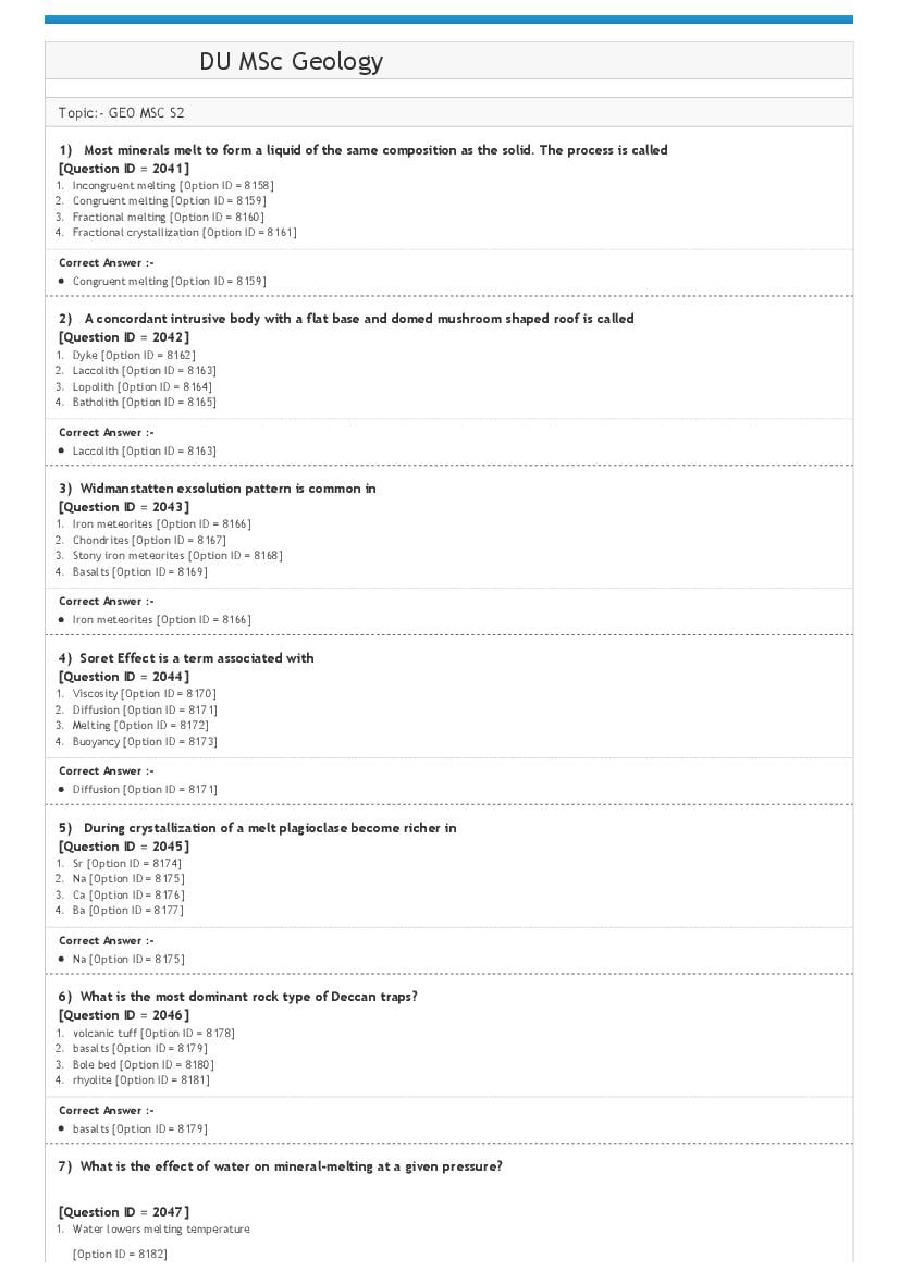
Topic:‐ GEO MSC S2
1) Most minerals melt to form a liquid of the same composition as the solid. The process is called
[Question ID = 2041]
1. Incongruent melting [Option ID = 8158]
2. Congruent melting [Option ID = 8159]
3. Fractional melting [Option ID = 8160]
4. Fractional crystallization [Option ID = 8161]
Congruent melting [Option ID = 8159]
2) A concordant intrusive body with a flat base and domed mushroom shaped roof is called
[Question ID = 2042]
1. Dyke [Option ID = 8162]
2. Laccolith [Option ID = 8163]
3. Lopolith [Option ID = 8164]
4. Batholith [Option ID = 8165]
Laccolith [Option ID = 8163]
3) Widmanstatten exsolution pattern is common in
[Question ID = 2043]
1. Iron meteorites [Option ID = 8166]
2. Chondrites [Option ID = 8167]
3. Stony iron meteorites [Option ID = 8168]
4. Basalts [Option ID = 8169]
Iron meteorites [Option ID = 8166]
4) Soret Effect is a term associated with
[Question ID = 2044]
1. Viscosity [Option ID = 8170]
2. Diffusion [Option ID = 8171]
3. Melting [Option ID = 8172]
4. Buoyancy [Option ID = 8173]
Diffusion [Option ID = 8171]
5) During crystallization of a melt plagioclase become richer in
[Question ID = 2045]
1. Sr [Option ID = 8174]
2. Na [Option ID = 8175]
3. Ca [Option ID = 8176]
4. Ba [Option ID = 8177]
Na [Option ID = 8175]
6) What is the most dominant rock type of Deccan traps?
[Question ID = 2046]
1. volcanic tuff [Option ID = 8178]
2. basalts [Option ID = 8179]
3. Bole bed [Option ID = 8180]
4. rhyolite [Option ID = 8181]
basalts [Option ID = 8179]
7) What is the effect of water on mineral‐melting at a given pressure?
[Question ID = 2047]
1. Water lowers melting temperature
[Option ID = 8182]
Page 2
[Option ID = 8183]
3. Does not affect melting temperature
[Option ID = 8184]
4. None of these
[Option ID = 8185]
Water lowers melting temperature
[Option ID = 8182]
8) Which of the following Nesosilicates is a common constituent of basalt?
[Question ID = 2048]
1. Garnet [Option ID = 8186]
2. Olivine [Option ID = 8187]
3. Silimanite [Option ID = 8188]
4. Zircon [Option ID = 8189]
Garnet [Option ID = 8186]
9) The acute bisectrix figure is observed on a crystal plate
[Question ID = 2049]
1. Cut normal to obtuse bisectrix [Option ID = 8190]
2. Cut normal to acute bisectrix [Option ID = 8191]
3. Cut parallel to optic axes [Option ID = 8192]
4. Cut parallel to acute bisectrix [Option ID = 8193]
Cut normal to acute bisectrix [Option ID = 8191]
10) Jadeite is a type of
[Question ID = 2050]
1. Olivine [Option ID = 8194]
2. Mica [Option ID = 8195]
3. Pyroxene [Option ID = 8196]
4. Amphibole [Option ID = 8197]
Pyroxene [Option ID = 8196]
11) If in a deforming rock body, stress is found to be proportional to strain rate, the material (rock) behaviour is called
[Question ID = 2051]
1. Elastic [Option ID = 8198]
2. Plastic [Option ID = 8199]
3. Elastico‐viscous [Option ID = 8200]
4. Viscous [Option ID = 8201]
Viscous [Option ID = 8201]
12) If a stretching lineation is found on a cleavage plane, the direction of maximum shortening is likely to be:
[Question ID = 2052]
1. Parallel to the lineation, on the cleavage plane [Option ID = 8202]
2. Perpendicular to the lineation, on the cleavage plane [Option ID = 8203]
3. Perpendicular to the cleavage, parallel to the lineation [Option ID = 8204]
4. Perpendicular to both the cleavage plane and the lineation. [Option ID = 8205]
Perpendicular to both the cleavage plane and the lineation. [Option ID = 8205]
13) A rock shows very well developed foliation, but no distinct lineation (S‐tectonite). The type of strain most likely
representative of the deformation is
[Question ID = 2053]
1. Pure flattening [Option ID = 8206]
2. General flattening [Option ID = 8207]
3. Plane strain [Option ID = 8208]
4. Pure constriction. [Option ID = 8209]
Pure flattening [Option ID = 8206]
14) According to Anderson’s theory of faulting, the principal stress axis σ1 (maximum compressive stress) should be vertical
Page 3
[Question ID = 2054]
1. Strike‐slip faulting [Option ID = 8210]
2. Normal faulting [Option ID = 8211]
3. Reverse faulting [Option ID = 8212]
4. Wrench faulting. [Option ID = 8213]
Normal faulting [Option ID = 8211]
15) A fault plane strikes N‐S and dips 70° E. On the fault plane, the slickenside lineations show a pitch of 65° northerly.
Which of the following interpretations is correct?
[Question ID = 2055]
1. It is an oblique‐slip reverse fault with sinistral sense wrench component
[Option ID = 8214]
2. It is an oblique‐slip normal fault with sinistral sense wrench component
[Option ID = 8215]
3. It is an oblique slip normal fault with a dextral sense wrench component
[Option ID = 8216]
4. It is a strike‐slip fault with sinistral wrench component.
[Option ID = 8217]
It is an oblique‐slip normal fault with sinistral sense wrench component
[Option ID = 8215]
16) Humans dispersed out from —————— center of origin
[Question ID = 2056]
1. African [Option ID = 8218]
2. Asian [Option ID = 8219]
3. European [Option ID = 8220]
4. American. [Option ID = 8221]
African [Option ID = 8218]
17) Glossopteris became less diverse in
[Question ID = 2057]
1. Permian
[Option ID = 8222]
2. Cretaceous
[Option ID = 8223]
3. Triassic
[Option ID = 8224]
4. Jurassic
[Option ID = 8225]
Triassic
[Option ID = 8224]
18) Mesozoic reefs are formed primarily by
[Question ID = 2058]
1. Sponges
[Option ID = 8226]
2. Archaeocyathids
[Option ID = 8227]
3. Rugose corals
[Option ID = 8228]
4. Scleractinian corals
[Option ID = 8229]
Scleractinian corals
Page 4
19) A taxon that disappears for one or more periods from the fossil record, and reappears later is called as
[Question ID = 2059]
1. Zombie taxon [Option ID = 8230]
2. Ghost taxon [Option ID = 8231]
3. Elvis taxon [Option ID = 8232]
4. Lazarus taxon [Option ID = 8233]
Lazarus taxon [Option ID = 8233]
20) Pascichnia is term used for
[Question ID = 2060]
1. Grazing traces [Option ID = 8234]
2. Crawling traces [Option ID = 8235]
3. Resting traces [Option ID = 8236]
4. Dwelling traces [Option ID = 8237]
Grazing traces [Option ID = 8234]
21) When an organism achieves sexual maturity as a juvenile, the heterochronic change is termed as
[Question ID = 2061]
1. Pedomorphosis
[Option ID = 8238]
2. Peramorphosis
[Option ID = 8239]
3. Atavism
[Option ID = 8240]
4. None of these
[Option ID = 8241]
Pedomorphosis
[Option ID = 8238]
22) Hyalophane is a
[Question ID = 2062]
1. Mica [Option ID = 8242]
2. Feldspar [Option ID = 8243]
3. Feldspathoid [Option ID = 8244]
4. Amphibole [Option ID = 8245]
Feldspar [Option ID = 8243]
23) Choose the correct option from the following:
[Question ID = 2063]
1. Parallelism of internal and external schistosity implies syn‐deformation growth of porphyroblast [Option ID = 8246]
2. Poikilitic texture is a metamorphic texture [Option ID = 8247]
3. Antiperthite is an exsolution texture [Option ID = 8248]
4. Granofels are associated with regional metamorphism [Option ID = 8249]
Antiperthite is an exsolution texture [Option ID = 8248]
24) Which amongst the following is a 1:1 phyllosilicate?
[Question ID = 2064]
1. Illite
[Option ID = 8250]
2. Kaolinite
[Option ID = 8251]
3. Montmorillonite
[Option ID = 8252]
4. Chlorite
[Option ID = 8253]
Page 5
[Option ID = 8251]
25) Closest packing of equal sized spheres of cations and anions will lead to coordination number of
[Question ID = 2065]
1. 6 [Option ID = 8254]
2. 12 [Option ID = 8255]
3. 4 [Option ID = 8256]
4. 8 [Option ID = 8257]
12 [Option ID = 8255]
26) Monticellite is a
[Question ID = 2066]
1. Single chain silicate [Option ID = 8258]
2. Nesosilicate [Option ID = 8259]
3. Double chain silicate [Option ID = 8260]
4. Tectosilicate [Option ID = 8261]
Nesosilicate [Option ID = 8259]
27) Khetri copper belt is part of
[Question ID = 2067]
1. South Delhi Fold Belt [Option ID = 8262]
2. Aravalli Supergroup [Option ID = 8263]
3. North Delhi Fold Belt [Option ID = 8264]
4. Marwar Group [Option ID = 8265]
Aravalli Supergroup [Option ID = 8263]
28) Abukama facies series is a
[Question ID = 2068]
1. High P‐low T series
[Option ID = 8266]
2. Low P‐high T series
[Option ID = 8267]
3. Intermdiate PT series
[Option ID = 8268]
4. None of these
[Option ID = 8269]
Low P‐high T series
[Option ID = 8267]
29) Reaction “cummingtonite = orthopyroxene+quartz+H2O” indicates that
[Question ID = 2069]
1. It is a hydration reaction [Option ID = 8270]
2. It is an ion‐exchange reaction [Option ID = 8271]
3. Cummingtonite has high alumina content [Option ID = 8272]
4. Cummingtonite contains low to no alumina [Option ID = 8273]
Cummingtonite contains low to no alumina [Option ID = 8273]
30) When all four oxygens in silicon tetrahedral are shared, the structure is known as
[Question ID = 2070]
1. Chain silicates [Option ID = 8274]
2. Ring silicates [Option ID = 8275]
3. Framework silicates [Option ID = 8276]
4. Cyclosilicates [Option ID = 8277]
Framework silicates [Option ID = 8276]
Page 6
projected from
[Question ID = 2071]
1. Muscovite [Option ID = 8278]
2. Quartz [Option ID = 8279]
3. Biotite [Option ID = 8280]
4. K feldspar [Option ID = 8281]
Muscovite [Option ID = 8278]
32) The main reason for seasons is
[Question ID = 2072]
1. The Sun gets hotter and colder [Option ID = 8282]
2. Variable positions of moon with respect to Sun and Earth [Option ID = 8283]
3. The tilt of the Earth’s axis [Option ID = 8284]
4. The variable distance between Sun and Earth [Option ID = 8285]
The tilt of the Earth’s axis [Option ID = 8284]
33) Knob and kettle topography forms when
[Question ID = 2073]
1. Blocks of ice get buried by till, and then melt. [Option ID = 8286]
2. The glacier flows over sediment and molds it into streamlined hills. [Option ID = 8287]
3. Ice plucks chunks off of bedrock and leaves an indentation. [Option ID = 8288]
4. Rocks embedded in the base of the glacier gouge out deep depressions into bedrock [Option ID = 8289]
Blocks of ice get buried by till, and then melt. [Option ID = 8286]
34) The sluggish wind system in the equatorial areas is known as?
[Question ID = 2074]
1. Westerlies [Option ID = 8290]
2. Trades [Option ID = 8291]
3. Doldrums [Option ID = 8292]
4. Monsoon [Option ID = 8293]
Doldrums [Option ID = 8292]
35) The Digboi Oil Field is associated with rocks of
[Question ID = 2077]
1. Eocene age [Option ID = 8300]
2. Miocene age [Option ID = 8302]
3. Pleistocene age [Option ID = 8303]
4. Pliocene age [Option ID = 8305]
Miocene age [Option ID = 8302]
36) The Ninety East Ridge is present in which of the following oceans
[Question ID = 2078]
1. Atlantic [Option ID = 8306]
2. Indian [Option ID = 8308]
3. Pacific [Option ID = 8310]
4. Arctic [Option ID = 8311]
Indian [Option ID = 8308]
37) What are ophiolite suites?
[Question ID = 2080]
1. Fragments of oceanic lithosphere emplaced on a continent [Option ID = 8314]
2. Groups of seafloor magnetic anomalies [Option ID = 8315]
3. Wedge‐shaped packages of sediments that form at passive margins [Option ID = 8317]
4. Rocks with ophitic texture [Option ID = 8318]
Fragments of oceanic lithosphere emplaced on a continent [Option ID = 8314]
38) Which of the following deep sea sediments is often part of ophiolite suites
[Question ID = 2083]
Page 7
[Option ID = 8322]
2. Globigerina ooze
[Option ID = 8325]
3. Radiolarian chert
[Option ID = 8327]
4. Pteropod ooze
[Option ID = 8329]
Radiolarian chert
[Option ID = 8327]
39) When does the Intertropical convergence Zone reach its most northerly location?
[Question ID = 2084]
1. July [Option ID = 8330]
2. April [Option ID = 8332]
3. January [Option ID = 8334]
4. October [Option ID = 8336]
July [Option ID = 8330]
40) Ocean acidification is gradually increasing with time as a result of
[Question ID = 2087]
1. Photosynthesis [Option ID = 8340]
2. Increasing pollution [Option ID = 8343]
3. Upwelling [Option ID = 8344]
4. Increasing atmospheric CO2 concentrations [Option ID = 8345]
Increasing atmospheric CO2 concentrations [Option ID = 8345]
41) The Ice‐rafted debris‐rich layers in the North Atlantic during Quaternary are referred to
[Question ID = 2088]
1. ENSO events
[Option ID = 8346]
2. Monsoonal events
[Option ID = 8347]
3. Heinrich events
[Option ID = 8349]
4. Interstadial events
[Option ID = 8351]
Heinrich events
[Option ID = 8349]
42) Because of difference in density, Icebergs float for a distance of several kilometers in sea before its gets completely
melted. The difference in density between ice formed of pure water and sea water is
[Question ID = 2090]
1. 0.005 gm/cc
[Option ID = 8354]
2. 0.105 gm/cc
[Option ID = 8356]
3. 01.05 gm/cc
[Option ID = 8358]
4. 0.015 gm/cc
[Option ID = 8359]
0.105 gm/cc
[Option ID = 8356]
43) In cumulative percentage probability curve a well‐sorted sandstone will plot as
Page 8
1. A sigmoidal curve [Option ID = 8363]
2. A low gradient straight line [Option ID = 8365]
3. A high‐gradient straight line [Option ID = 8367]
4. A bell‐shaped curve [Option ID = 8368]
A high‐gradient straight line [Option ID = 8367]
44) Sandy coastline with an extensive area of beach directly adjacent to the coastal plain is termed a
[Question ID = 2094]
1. Shoreface [Option ID = 8370]
2. Chenier [Option ID = 8371]
3. Foreshore [Option ID = 8372]
4. Strand plain [Option ID = 8374]
Strand plain [Option ID = 8374]
45) We get botryoidal cement geometry in carbonate that has gone through
[Question ID = 2096]
1. Vadose diagenesis [Option ID = 8378]
2. Deep burial diagenesis [Option ID = 8379]
3. Phreatic diagenesis [Option ID = 8380]
4. Sea floor diagenesis [Option ID = 8381]
Sea floor diagenesis [Option ID = 8381]
46) We get grain flows commonly in
[Question ID = 2097]
1. Moderately sorted granular sediments [Option ID = 8382]
2. Ill sorted granular sediments [Option ID = 8383]
3. Well sorted granular sediments [Option ID = 8384]
4. Clayey sediments [Option ID = 8385]
Well sorted granular sediments [Option ID = 8384]
47) If ‘F’ represents direction of Earth’s magnetic field at any station, the local magnetic meridian at that station will be
[Question ID = 2098]
1. A plane assuming an angle between ‘F’ and its horizontal projection ‘H’ [Option ID = 8386]
2. A vertical plane passing through ‘F’ and its horizontal projection ‘H’ [Option ID = 8387]
3. A plane that holds ‘F’ [Option ID = 8388]
4. A plane that passes through ‘F’ and magnetic north of the Earth [Option ID = 8389]
A vertical plane passing through ‘F’ and its horizontal projection ‘H’ [Option ID = 8387]
48) We call a flow ‘in phase’ flow when
[Question ID = 2099]
1. Reynold number of flow is >2000
[Option ID = 8390]
2. Reynold number of flow is <2000
[Option ID = 8391]
3. Froud number of flow is <1
[Option ID = 8392]
4. Froud number of flow is >1
[Option ID = 8393]
Froud number of flow is >1
[Option ID = 8393]
49) We can expect forearc sandstones as
[Question ID = 2100]
1. Quatrzose in nature [Option ID = 8394]
2. Quartzofeldspathic in nature [Option ID = 8395]
3. Quartzolithic in nature [Option ID = 8396]
4. Feldspathic in nature [Option ID = 8397]
Page 9
50) In Jodhpur, Rajasthan exposures of Jodhpur Sandstones are found overlying the Malani rhyolite. The contact between
the two can be best described as
[Question ID = 2101]
1. Nonconformity [Option ID = 8398]
2. Paraconformity [Option ID = 8399]
3. Disconformity [Option ID = 8400]
4. Angular unconformity [Option ID = 8401]
Nonconformity [Option ID = 8398]
51) ‐‐‐‐‐‐‐‐‐‐‐‐‐‐‐‐‐‐‐‐‐‐‐‐ are intrabed soft sediment deformation features
[Question ID = 2102]
1. Convolute lamination and overturned cross‐stratification [Option ID = 8402]
2. Load cast and convolute lamination [Option ID = 8403]
3. Flame structure and overturned cross‐stratification [Option ID = 8404]
4. Load cast and Flame structure [Option ID = 8405]
Convolute lamination and overturned cross‐stratification [Option ID = 8402]
52) When streams appear to be far too small with respect to their valley, they are called as
[Question ID = 2103]
1. Paleochannel [Option ID = 8406]
2. Inland stream [Option ID = 8407]
3. Misfit stream [Option ID = 8408]
4. Seasonal stream [Option ID = 8409]
Misfit stream [Option ID = 8408]
53) Fracturing of the ground by thermal contraction at sub‐freezing temperature is called as
[Question ID = 2104]
1. Fracking [Option ID = 8410]
2. Desiccation cracking [Option ID = 8411]
3. Frost cracking [Option ID = 8412]
4. Dilation cracking [Option ID = 8413]
Frost cracking [Option ID = 8412]
54) Which of the following features could help you identify the presence of glaciers in a region in the past?
[Question ID = 2105]
1. Chatter marks
[Option ID = 8414]
2. Terminal moraine
[Option ID = 8415]
3. Drumlins
[Option ID = 8416]
4. All of these
[Option ID = 8417]
All of these
[Option ID = 8417]
55) Which of the following statements is true?
[Question ID = 2106]
1. Sand has higher porosity than clay
[Option ID = 8418]
2. Mud has higher porosity than sand
[Option ID = 8419]
3. Mud has higher permeability than sand
[Option ID = 8420]
4. None of these
Page 10
Mud has higher permeability than sand
[Option ID = 8420]
56) The increase in velocity leads to a drop in pressure above the grain and is known as the
[Question ID = 2107]
1. Bernoulli effect [Option ID = 8422]
2. Stokes effect [Option ID = 8423]
3. Chezy's effect [Option ID = 8424]
4. Mannings effect [Option ID = 8425]
Bernoulli effect [Option ID = 8422]
57) Darcy law states that
[Question ID = 2108]
1. Velocity is inversely proportional to hydraulic gradient [Option ID = 8426]
2. Velocity is directly proportional to hydraulic gradient [Option ID = 8427]
3. Velocity is not related to the hydraulic gradient [Option ID = 8428]
4. Velocity is proportional to specific yield [Option ID = 8429]
Velocity is directly proportional to hydraulic gradient [Option ID = 8427]
58) In which environment will you find maximum soil thickness?
[Question ID = 2109]
1. Temperate
[Option ID = 8430]
2. Semi‐arid
[Option ID = 8431]
3. Tropical
[Option ID = 8432]
4. None of these
[Option ID = 8433]
Tropical
[Option ID = 8432]
59) UTM in GIS stands for
[Question ID = 2110]
1. Universal Transverse Mercator
[Option ID = 8434]
2. Unclassified Thematic Map
[Option ID = 8435]
3. Universal Tasseled Map
[Option ID = 8436]
4. None of these
[Option ID = 8437]
Universal Transverse Mercator
[Option ID = 8434]
60) The dimension of Storativity is
[Question ID = 2111]
1. LT‐1 [Option ID = 8438]
2. L 2T ‐1 [Option ID = 8439]
3. L 3T ‐1 [Option ID = 8440]
4. Dimensionless [Option ID = 8441]
Dimensionless [Option ID = 8441]
Page 11
[Question ID = 2112]
1. Kames [Option ID = 8442]
2. Moraines [Option ID = 8443]
3. Esker [Option ID = 8444]
4. Arête [Option ID = 8445]
Arête [Option ID = 8445]
62) The Ediacaran fossils are characterized by
[Question ID = 2113]
1. Colony of unicellular organism [Option ID = 8446]
2. Small Shelly fauna [Option ID = 8447]
3. Multi‐cellular metazoans [Option ID = 8448]
4. Stromatolite colony [Option ID = 8449]
Multi‐cellular metazoans [Option ID = 8448]
63) Bijli rhyolite is associated with
[Question ID = 2114]
1. Singhbhum craton [Option ID = 8450]
2. Bastar craton [Option ID = 8451]
3. Dharwar craton [Option ID = 8452]
4. Aravalli craton [Option ID = 8453]
Bastar craton [Option ID = 8451]
64) Best quality of Indian coking coal is produced from:
[Question ID = 2115]
1. Jharia coalfield [Option ID = 8454]
2. Bokaro coalfield [Option ID = 8455]
3. Raniganj coalfield [Option ID = 8456]
4. Jabalpur coalfield [Option ID = 8457]
Raniganj coalfield [Option ID = 8456]
65) Graptolites disappeared at the end of:
[Question ID = 2116]
1. Cambrian [Option ID = 8458]
2. Silurian [Option ID = 8459]
3. Ordovician [Option ID = 8460]
4. Carboniferous [Option ID = 8461]
Silurian [Option ID = 8459]
66) Taphonomy is the science dealing with
[Question ID = 2117]
1. Study of the conditions of burial of fossils [Option ID = 8462]
2. Reconstruction of paleoenvironment by means of fossils [Option ID = 8463]
3. Mode of preservation of fossils [Option ID = 8464]
4. Study of fossil spore and pollens [Option ID = 8465]
Mode of preservation of fossils [Option ID = 8464]
67) Which of the following biostratigraphic zone shows time correlative plane?
[Question ID = 2118]
1. Acme biozone [Option ID = 8466]
2. Interval biozone [Option ID = 8467]
3. Lineage biozone [Option ID = 8468]
4. Assemblage biozone [Option ID = 8469]
Lineage biozone [Option ID = 8468]
68) A disconformity indicates
[Question ID = 2119]
1. A rock unit that does not contain fossils [Option ID = 8470]
2. An erosional surface between igneous and metamorphic rocks [Option ID = 8471]
3. An erosional surface between different rock types [Option ID = 8472]
Page 12
An erosional surface between horizontal sedimentary rocks [Option ID = 8473]
69) First leaves and flowers appeared during
[Question ID = 2120]
1. Early Cretaceous [Option ID = 8474]
2. Early Jurassic [Option ID = 8475]
3. Late Cretaceous [Option ID = 8476]
4. Late Triassic [Option ID = 8477]
Late Cretaceous [Option ID = 8476]
70) Stratigraphic succession in Deccan trap is erected with the help of
[Question ID = 2121]
1. Giant plagioclase laths in basalt
[Option ID = 8478]
2. Inter‐trappean and bole beds
[Option ID = 8479]
3. Magnetic reversal record in basalt
[Option ID = 8480]
4. All of these
[Option ID = 8481]
All of these
[Option ID = 8481]
71) An influent stream has
[Question ID = 2122]
1. Water in the stream at higher elevation than water table elevation [Option ID = 8482]
2. Water in the stream at lower elevation than water table elevation [Option ID = 8483]
3. Water in the stream at equal elevation to the water table elevation [Option ID = 8484]
4. No water flows on either side [Option ID = 8485]
Water in the stream at higher elevation than water table elevation [Option ID = 8482]
72) The ~30 % of the sedimentary shell of Earth is marked by …………
[Question ID = 2123]
1. Shale [Option ID = 8486]
2. Sandstone [Option ID = 8487]
3. Conglomerate [Option ID = 8488]
4. Limestone [Option ID = 8489]
Sandstone [Option ID = 8487]
73) The incipient stage weathering is marked by
[Question ID = 2124]
1. Smectite‐Vermiculite
[Option ID = 8490]
2. Illite‐Chlorite
[Option ID = 8491]
3. Illite‐Kaolinite
[Option ID = 8492]
4. Kaolinite‐chlorite
[Option ID = 8493]
Smectite‐Vermiculite
[Option ID = 8490]
74) Which of the following bedforms represents upstream migration?
[Question ID = 2125]
Page 13
2. Dunes [Option ID = 8495]
3. Antidune [Option ID = 8496]
4. Ripple cross beds [Option ID = 8497]
Antidune [Option ID = 8496]
75) Which of the following statement is related to the formation of polymictic conglomerate?
[Question ID = 2126]
1. Many single types of clasts [Option ID = 8498]
2. Continuous recycling [Option ID = 8499]
3. Rapid erosion, transportation and deposition [Option ID = 8500]
4. Quartzose conglomerates [Option ID = 8501]
Rapid erosion, transportation and deposition [Option ID = 8500]
76) The lateral accretion in a meandering channel refers to
[Question ID = 2127]
1. Overbank depositions, [Option ID = 8502]
2. Levees formation [Option ID = 8503]
3. Point bar formation [Option ID = 8504]
4. Formation of soils [Option ID = 8505]
Point bar formation [Option ID = 8504]
77) Which of the following plant fossil is found in Upper Gondwana?
[Question ID = 2128]
1. Glossopteris [Option ID = 8506]
2. Schizoneura [Option ID = 8507]
3. Nilssonia [Option ID = 8508]
4. Vertebraria [Option ID = 8509]
Nilssonia [Option ID = 8508]
78) The Kosi alluvail fan is a:
[Question ID = 2129]
1. Small arid alluvail fan [Option ID = 8510]
2. Large arid alluvail fan [Option ID = 8511]
3. Very large humid alluvail fan [Option ID = 8512]
4. Very small humid alluvail fan [Option ID = 8513]
Very large humid alluvail fan [Option ID = 8512]
79) The youngest of the major thrust sheets across the Himalaya is
[Question ID = 2130]
1. MBT [Option ID = 8514]
2. MCT [Option ID = 8515]
3. ITSZ [Option ID = 8516]
4. MFT [Option ID = 8517]
MFT [Option ID = 8517]
80) The plagioclase with An10 to An30 is known as
[Question ID = 2131]
1. Albite [Option ID = 8518]
2. Oligoclase [Option ID = 8519]
3. Andesine [Option ID = 8520]
4. Anorthite [Option ID = 8521]
Oligoclase [Option ID = 8519]
81) Which of the following is not a monoclinic pyroxene?
[Question ID = 2132]
1. Diopside [Option ID = 8522]
2. Spodumene [Option ID = 8523]
3. Enstatite [Option ID = 8524]
4. Jadeite [Option ID = 8525]
Page 14
82) A catchment on the toposheet 44D/16 has an area of 16 cm2, this corresponds to …… on land
[Question ID = 2133]
1. 4 km2 [Option ID = 8526]
2. 8 km2 [Option ID = 8527]
3. 12 km2 [Option ID = 8528]
4. 16 km2 [Option ID = 8529]
4 km2 [Option ID = 8526]
83) The Toba ash after the large volcanic eruption in Sumatra occurred at
[Question ID = 2134]
1. 10 ka [Option ID = 8530]
2. 25 ka [Option ID = 8531]
3. 50 ka [Option ID = 8532]
4. 75 ka [Option ID = 8533]
75 ka [Option ID = 8533]
84) The youngest Stage on the geological time scale is defined by
[Question ID = 2135]
1. Greenlandian [Option ID = 8534]
2. Meghalayan [Option ID = 8535]
3. Northgrippian [Option ID = 8536]
4. Calabrian [Option ID = 8537]
Meghalayan [Option ID = 8535]
85) The Archaean‐Proterozoic transition is marked at
[Question ID = 2136]
1. 4000 Ma [Option ID = 8538]
2. 3000 Ma [Option ID = 8539]
3. 2500 Ma [Option ID = 8540]
4. 1000 Ma [Option ID = 8541]
2500 Ma [Option ID = 8540]
86) Permian‐ Triassic extinction occurred at about
[Question ID = 2137]
1. 250 Ma [Option ID = 8542]
2. 350 Ma [Option ID = 8543]
3. 450 Ma [Option ID = 8544]
4. 200 Ma [Option ID = 8545]
250 Ma [Option ID = 8542]
87) The average depth of the oceans is about
[Question ID = 2138]
1. 1.5 km [Option ID = 8546]
2. 2.5 km [Option ID = 8547]
3. 3.5 km [Option ID = 8548]
4. 4.5 km [Option ID = 8549]
3.5 km [Option ID = 8548]
88) Which of the following tectonic units separates the Vindhyan supergroup and the Archaean supracrustal in the north
western India?
[Question ID = 2139]
1. Main Central Thrust (MCT) [Option ID = 8550]
2. Himalayan Frontal Thrust (HFT) [Option ID = 8551]
3. Central India Tectonic Zone (CITZ) [Option ID = 8552]
4. Great Boundary Fault (GBF) [Option ID = 8553]
Great Boundary Fault (GBF) [Option ID = 8553]
Page 15
[Question ID = 2140]
1. Rohtas Formation [Option ID = 8554]
2. Khenjua Formation [Option ID = 8555]
3. Porcellanite Formation [Option ID = 8556]
4. Deoland Formation [Option ID = 8557]
Rohtas Formation [Option ID = 8554]
90) The Polarity chron C29R/C29N transition is related to
[Question ID = 2141]
1. K‐T Boundary [Option ID = 8558]
2. P‐T Boundary [Option ID = 8559]
3. Jurassic‐Cretaceous boundary [Option ID = 8560]
4. P‐C boundary [Option ID = 8561]
K‐T Boundary [Option ID = 8558]
91) Which of the following is not related to Kimberlite?
[Question ID = 2142]
1. Wajrakurur [Option ID = 8562]
2. Behradih [Option ID = 8563]
3. Majhgawan [Option ID = 8564]
4. Ambadonger [Option ID = 8565]
Ambadonger [Option ID = 8565]
92) An aquifer bounded on top and bottom by impervious layers is :
[Question ID = 2143]
1. Semiconfined aquifer [Option ID = 8566]
2. Unconfined aquifer [Option ID = 8567]
3. Confined aquifer [Option ID = 8568]
4. Perched [Option ID = 8569]
Confined aquifer [Option ID = 8568]
93) The polymetallic nodules at the abyssal floor are dominated by
[Question ID = 2144]
1. Mn‐Fe [Option ID = 8570]
2. Cu‐Ni [Option ID = 8571]
3. Pb‐Zn [Option ID = 8572]
4. Co‐Ni [Option ID = 8573]
Mn‐Fe [Option ID = 8570]
94) The average salinity of the oceans is about
[Question ID = 2145]
1. 1.0% [Option ID = 8574]
2. 2.0% [Option ID = 8575]
3. 3.5% [Option ID = 8576]
4. 5.0% [Option ID = 8577]
3.5% [Option ID = 8576]
95) Which of the following is true for the river water?
[Question ID = 2146]
1. HCO3 > SO4 > Cl
[Option ID = 8578]
2. HCO3= SO4 = Cl
[Option ID = 8579]
3. HCO3< SO4< Cl
[Option ID = 8580]
4. Cl> HCO3> SO4
[Option ID = 8581]
Page 16
[Option ID = 8578]
96) Which of the following is true for the ocean water?
[Question ID = 2147]
1. Ca>Na>Mg [Option ID = 8582]
2. Na>Mg>Ca [Option ID = 8583]
3. Mg>Ca>Na [Option ID = 8584]
4. Ca>Mg>Na [Option ID = 8585]
Na>Mg>Ca [Option ID = 8583]
97) Calcite is a uniaxial (‐ve) mineral, because for calcite
[Question ID = 2148]
1. nE < nO
[Option ID = 8586]
2. nE = nO
[Option ID = 8587]
3. nE > nO
[Option ID = 8588]
4. nE >> nO
[Option ID = 8589]
nE < nO
[Option ID = 8586]
98) Nicol prism is characterized by
[Question ID = 2149]
1. Total reflection of extra‐ordinary rays but transmission of ordinary ray [Option ID = 8590]
2. Total reflection of ordinary rays but transmission of extra‐ ordinary ray [Option ID = 8591]
3. Total reflection of both ordinary ray and the extra‐ordinary ray [Option ID = 8592]
4. Transmission of both ordinary ray and the extra‐ordinary ray [Option ID = 8593]
Total reflection of ordinary rays but transmission of extra‐ ordinary ray [Option ID = 8591]
99) A fluvial system in general is defined by
[Question ID = 2150]
1. Catchment [Option ID = 8594]
2. Transport [Option ID = 8595]
3. Deposition [Option ID = 8596]
4. Catchment + Transport + Deposition [Option ID = 8597]
Catchment + Transport + Deposition [Option ID = 8597]
100) The PETM event is defined by
[Question ID = 2151]
1. 5°C to 6 °C rise in temperature at 55 Ma [Option ID = 8598]
2. 5°C to 6 °C cooling in temperature at 65 Ma [Option ID = 8599]
3. 15°C to 16 °C rise in temperature at 55 Ma [Option ID = 8600]
4. 15°C to 16 °C cooling in temperature at 65 Ma [Option ID = 8601]
5°C to 6 °C rise in temperature at 55 Ma [Option ID = 8598]
Document Details
| Board / Org | NTA |
| Exam | DUET |
| Type | Question Paper |
| Pages | 16 |
| Updated | 22 Jul 2026 |