PU CET PG 2018 Question Paper M.A._Geography_
Finished viewing? Save it for later —
Download PU CET PG 2018 Question Paper M.A._Geography_ (PDF · 7 pages)About PU CET PG 2018 Question Paper M.A._Geography_
PU CET PG 2018 Question Paper M.A._Geography_ is available here for free download. Published by Punjab University for PU CET PG, this question paper can be viewed online or downloaded as a PDF (7 pages). Candidates preparing for PU CET PG can use PU CET PG 2018 Question Paper M.A._Geography_ to understand the exam pattern, the type of questions asked, and the overall difficulty level.
Frequently Asked Questions
How can I download PU CET PG 2018 Question Paper M.A._Geography_?
Open this page and click the Download button to save PU CET PG 2018 Question Paper M.A._Geography_ as a PDF. It is completely free on AglaSem Docs.
Is PU CET PG 2018 Question Paper M.A._Geography_ free to download?
Yes. PU CET PG 2018 Question Paper M.A._Geography_ can be viewed online and downloaded as a PDF free of cost on AglaSem Docs.
How many pages does PU CET PG 2018 Question Paper M.A._Geography_ have?
PU CET PG 2018 Question Paper M.A._Geography_ contains 7 pages, which you can read online or download together as a single PDF.
Where can I find more PU CET PG study material?
You can find more PU CET PG question papers, sample papers, syllabus, and answer keys on AglaSem Docs.
PU CET PG 2018 Question Paper M.A._Geography_ – Text
Read the full text of this question paper below — useful to quickly search, copy and reference the content online without downloading the PDF.
📄 View text version (7 pages)
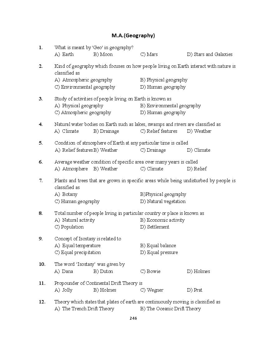
Page 1
1. What is meant by 'Geo' in geography?
A) Earth B) Moon C) Mars D) Stars and Galaxies
2. Kind of geography which focuses on how people living on Earth interact with nature is
classified as
A) Atmospheric geography B) Physical geography
C) Environmental geography D) Human geography
3. Study of activities of people living on Earth is known as
A) Physical geography B) Environmental geography
C) Atmospheric geography D) Human geography
4. Natural water bodies on Earth such as lakes, swamps and rivers are classified as
A) Climate B) Drainage C) Relief features D) Weather
5. Condition of atmosphere of Earth at any particular time is called
A) Relief features B) Weather C) Drainage D) Climate
6. Average weather condition of specific area over many years is called
A) Atmosphere B) Weather C) Climate D) Relief
7. Plants and trees that are grown in specific areas while being undisturbed by people is
classified as
A) Botany B)Physical geography
C) Human geography D) Natural vegetation
8. Total number of people living in particular country or place is known as
A) Natural activity B) Economic activity
C) Population D) Settlement
9. Concept of Isostasy is related to
A) Equal temperature B) Equal balance
C) Equal precipitation D) Equal pressure
10. The word ‘Isostasy’ was given by
A) Dana B) Duton C) Bowie D) Holmes
11. Propounder of Continental Drift Theory is
A) Jolly B) Holmes C) Wegner D) Prat
12. Theory which states that plates of earth are continuously moving is classified as
A) The Trench Drift Theory B) The Oceanic Drift Theory
246
Page 2
13. Thickness of outer core of Earth is about
A) 1,250 km B) 1,500 km C) 1,870 km D) 2,250 km
14. Plates that are made up of older rocks are classified as
A) Contraction plate B) Convection plate
C) Continental plate D) Oceanic plate
15. Alfred Wegener called the supercontinent
A) Wegenerland B) All lands C) Eurasia D) Pangea
16. ‘Nivation’ is
A) Accumulation of snow B) Erosion by wind
C) Erosion by snow D) Melting of snow
17. What is formed when two continental plates collide?
A) Island arcs B) Deep-sea trenches
C) Rift valleys D) Very tall mountain ranges
18. A Block mountain is also known as:
A) Horst B) Graben C) Fault D) Tableland
19. Average height of Tibetan Plateau is
A) 7200 meters B) 5000 meters C) 6500 meters D) 7000 meters
20. Tropical monsoon and equatorial climate are kinds of
A) Polar climate B) Temperate climate
C) Tropical climate D) Frontal climate
21. Process in which water vapors are released in air by leaves of plants is called
A) Respiration B) Precipitation C) Evaporation D) Transpiration
22. Inversion of temperature is
A) Increase of temperature with elevation
B) Decrease of temperature with elevation
C) Uniform temperature
D) Decrease of temperature with latitudes
23. Which type of drainage pattern is formed when tributaries join rivers at almost right
angles?
A) Dendritic drainage B) Trellis drainage
C) Rectangular drainage D) Radial drainage
247
Page 3
A) Wind B) Precipitation C) Humidity D) Temperature
25. Places where temperature of air is above freezing point of water, precipitation will be
in form of
A) Hailstorms B) Thunders C) Lightning D) Rain
26. Shapeless clouds that brings rain for longer period of time are classified as
A) Stevenson clouds B) Cumulus clouds
C) Stratus clouds D) Cirrus clouds
27. As compared to cold air, warm air is
A) Unsaturated B) Lighter C) Heavier D) Saturated
28. Monsoons in monsoon tropical climate areas are offshore in
A) Winter B) Summer C) Spring D) Autumn
29. Pressure of air is greatest at
A) Ridges B) Mountains C) Sea level D) Valleys
30. Instrument which is used to measure precipitation of particular place is known as
A) Storm scale B) Rain gauge C) Seismograph D) Thermometer
31. The rise and fall of sea water due to gravitation is known as
A) Tides B) Ocean currents C) Tsunami D) Waves
32. A rise in sea level near shore due to strong winds is called
A) Swell B) Tsunami C) Storm surge D) Whitecap
33. Periodic change towards unusual colder side is called
A) LA Nina B) El Nino C) Both A and B D) Upwelling
34. Neap tides occur when earth, sun and moon forms an angle of
A) 60 ° B) 90 ° C) 120 ° D) 180 °
35. Gulf stream carries water currents which are comparatively
A) Colder B) Warmer C) Hottest D) Coldest
36. Bubbles found in a crest of a breaking wave are called
A) Swell B) Tsunami C) Storm urge D) Whitecap
37. The fourth largest ocean is
A) Atlantic ocean B) Antarctic ocean
C) Arctic D) Indian ocean
38. Thick blue line on map is usually used to show
A) Electricity power station B) Stream
248
Page 4
39. Element of map which shows relationship between actual distance and length on map is
A) Grid line B) Key line C) Legend line D) Scale
40. Symbol on map that represents human and physical features on surface of Earth is
classified as
A) Legend B) Grid C) Key D) Both A and C
41. Symbols on map by which rivers, roads and railway tracks are represented are
A) Line symbols B) Point symbols
C) Height symbols D) Area symbols
42. Compass is usually used to find the
A) Movement of Moon B) Movement of Earth
C) Direction D) Distance
43. Which of the following is not a Quantitative Distribution Map?
A) Choroschematic Map B) Isopleth Map
C) Dot Map D) Choropleth Map
44. Occupational structure of population in India at state level is best represented by
A) Dot Method B) Isopleth C) Choropleth D) Pie Diagram
45. Considering types of maps, physical maps are used to show
A) Rainfalls B) Mountains and rivers
C) Atmosphere D) Rail road tracks and highways
46. Maps that shows detailed physical features of particular place are called
A) Topographical maps B) Atmospheric maps
C) Economic maps D) Symbolic maps
47. Imaginary lines that are used on maps to join places of same height are called
A) Legend Lines B) North Arrow Lines
C) Grid Lines D) Contour Lines
48. Choropleth map represent data with
A) Arrows of varying lengths B) Dots
C) Tonal Shading D) Special symbols
49. Symbols that are used to represent hospitals, schools and churches are classified as
A) Line symbols B) Point symbols
C) Height symbols D) Area symbols
249
Page 5
specific country, region or world are called
A) Airlines maps B) Political maps
C) Thematic maps D) Resource maps
51. Series of horizontal and vertical lines on map is classified as
A) Key lines B) Grid lines C) Scale lines D) Legend lines
52. Symbols that are used to describe area covering features such as farms and lakes are
called
A) Point symbols B) Height symbols
C) Area symbols D) Line symbols
53. Enlargement and reduction of map is done by
A) Planimeter B) Pantograph C) Clinometer D) Parallax bar
54. What is the total number of degrees of longitude in one hemisphere of the Earth?
A) 45 B) 90 C) 180 D) 270
55. The Mercator projection is actually which type of projection?
A) Conical B) Gnomonic C) Zenithal D) Cylindrical
56. On a topographic map, the closer the contour lines the
A) Gentler the slope B) Steeper the slope
C) Lower the elevation D) Flatter the land surface
57. If the contour interval on a topographic map is 10 meters, and one contour line is
labeled 50 m
A) The adjacent contour line would represent 10 m in elevation
B) The adjacent contour line would represent 40 m in elevation
C) The adjacent contour line would represent 60 m in elevation
D) The adjacent contour line would represent 150 m in elevation
58. The distance between contour lines on a topographic map is called the
A) Contour interval B) Contour index
C) Gradient D) Elevation
59. Contour lines that cross a valley or stream are
A) Dotted B) Solid C) V-shaped D) U-shaped
60. What is the other name of Zenithal projections?
A) Cylindrical projections B) Equal-area projections
C) Azimuthal projections D) Sinusoidal
61. Salinity becomes one of the factors for forming
A) Waves B) Ocean currents C) Tides D) Winds
250
Page 6
profiles are known as
A) Serial profiles B) Composite profiles
C) Superimposed profiles D) Projected profiles
63. Linear features like roads, railway or river are represented by
A) Serial profile B) Reconstructed profile
C) Longitudinal profile D) Projected profiles
64. What is the name of the Russian equivalent of GPS?
A) GLONASS B) GLASNOST C) GPESKI D) IKONOS
65. By ‘spatial data’ we mean data that has
A) Complex values B) Positional values
C) Graphic values D) Decimal values
66. ‘Spatial databases’ are also known as
A) Geodatabases B) Monodatabases
C) Concurrent databases D) None of these
67. The YarlungZangboriver, in India, is known as
A) Indus B) Mahanadi C) Brahmaputra D) Ganga
68. India's highest annual rainfall is reported at
A) Namchi, Sikkim B) Churu, Rajasthan
C) Mawsynram, Meghalaya D) Chamba, Himachal Pradesh
69. Three important rivers of the Indian subcontinent have their sources near the
Mansarover Lake in the Great Himalayas. These rivers are
A) Indus, Jhelum and Sutlej B) Brahmaputra, Indus and Sutlej
C) Jhelum, Sutlej and Yamuna D) Brahmaputra, Sutlej and Yamuna
70. The Andaman and Nicobar Islands are submerged parts of mountain range
A) ArakanYoma B) PeguYoma C) Askai Chin D) Tien Shan
71. When a volcano ejects acid lava, eruption is usually
A) Light and less violent B) Soft and less violent
C) Loud but less violent D) Loud and more violent
72. Smaller glacial valleys which are joined with main deeper valley are the
A) U-shaped valley B) Hanging valley
C) Deep valley D) Glacier valley
73. Sink holes and dolines are found in
A) Glacial topography B) Fluvial topography
C) Karst topography D) Aeolian topography
251
Page 7
A) South Africa B) Canada C) USA D) China
75. The point beyond which no trees can grow
A) Strait B) Timberline C) Tundra D) Channel
x-x-x
(6)
252
Document Details
| Board / Org | Panjab University |
| Exam | PU CET PG |
| Type | Question Paper |
| Pages | 7 |
| Updated | 22 Jul 2026 |