PU CET PG 2018 Question Paper Masters in Disaster Management
Finished viewing? Save it for later —
Download PU CET PG 2018 Question Paper Masters in Disaster Management (PDF · 7 pages)About PU CET PG 2018 Question Paper Masters in Disaster Management
PU CET PG 2018 Question Paper Masters in Disaster Management is available here for free download. Published by Punjab University for PU CET PG, this question paper can be viewed online or downloaded as a PDF (7 pages). Candidates preparing for PU CET PG can use PU CET PG 2018 Question Paper Masters in Disaster Management to understand the exam pattern, the type of questions asked, and the overall difficulty level.
Frequently Asked Questions
How can I download PU CET PG 2018 Question Paper Masters in Disaster Management?
Open this page and click the Download button to save PU CET PG 2018 Question Paper Masters in Disaster Management as a PDF. It is completely free on AglaSem Docs.
Is PU CET PG 2018 Question Paper Masters in Disaster Management free to download?
Yes. PU CET PG 2018 Question Paper Masters in Disaster Management can be viewed online and downloaded as a PDF free of cost on AglaSem Docs.
How many pages does PU CET PG 2018 Question Paper Masters in Disaster Management have?
PU CET PG 2018 Question Paper Masters in Disaster Management contains 7 pages, which you can read online or download together as a single PDF.
Where can I find more PU CET PG study material?
You can find more PU CET PG question papers, sample papers, syllabus, and answer keys on AglaSem Docs.
PU CET PG 2018 Question Paper Masters in Disaster Management – Text
Read the full text of this question paper below — useful to quickly search, copy and reference the content online without downloading the PDF.
📄 View text version (7 pages)
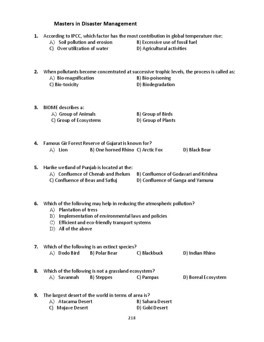
Page 1
1. According to IPCC, which factor has the most contribution in global temperature rise:
A) Soil pollution and erosion B) Excessive use of fossil fuel
C) Over utilization of water D) Agricultural activities
2. When pollutants become concentrated at successive trophic levels, the process is called as:
A) Bio-magnification B) Bio-poisoning
C) Bio-toxicity D) Biodegradation
3. BIOME describes a:
A) Group of Animals B) Group of Birds
C) Group of Ecosystems D) Group of Plants
4. Famous Gir Forest Reserve of Gujarat is known for?
A) Lion B) One horned Rhino C) Arctic Fox D) Black Bear
5. Harike wetland of Punjab is located at the:
A) Confluence of Chenab and Jhelum B) Confluence of Godavari and Krishna
C) Confluence of Beas and Satluj D) Confluence of Ganga and Yamuna
6. Which of the following may help in reducing the atmospheric pollution?
A) Plantation of tress
B) Implementation of environmental laws and policies
C) Efficient and eco-friendly transport systems
D) All of the above
7. Which of the following is an extinct species?
A) Dodo Bird B) Polar Bear C) Blackbuck D) Indian Rhino
8. Which of the following is not a grassland ecosystem?
A) Savannah B) Steppes C) Pampas D) Boreal Ecosystem
9. The largest desert of the world in terms of area is?
A) Atacama Desert B) Sahara Desert
C) Mojave Desert D) Gobi Desert
218
Page 2
A) Plants B) Humans C) Wild Animals D) Birds
11. The ‘Kyoto Protocol’ is committed to handle the issues related to:
A) Forest Degradation B) Water Pollution
C) Global Warming D) AIDS
12. Lion-Tailed Macaque is found in?
A) Western Himalayas B) Western Ghats
C) Indo-Gangetic Plains D) Siwalik Mountains
13. Which river is known as the ‘Sorrow of China’?
A) Indus B) Brahmaputra C) Hwang Ho D) Irrawaddy
14. Which desert of India is located in the western Rajasthan?
A) Mojave Desert B) Gobi Desert C) Thar Desert D) Gibson Desert
15. The renewable resources includes:
A) Water B) Oxygen C) Timber D) All of the above
16. Which of the following is a not a renewable resource of energy?
A) Solar Energy B) Petroleum C) Wind Energy D) Tidal Energy
17. Geothermal energy refers to energy derived from:
A) Coal B) Natural heat produced in the earth
C) Burning of wood D) Radioactive Substance
18. Which one of the following is NOT a tiger reserve?
A) Gir National Park B) Jim Corbett National Park
C) Kaziranga National Park D) Dudhwa National Park
19. In India, the required proportion of forest cover to maintain ecological balance is:
A) 13% B) 33% C) 21% D) 24%
20. What is the most likely cause of forest and wild fires:
219
Page 3
21. Organic Farming practice includes?
A) Use of Chemical Pesticides
B) Use of Saline Water
C) Cultivation without Chemical fertilizers and pesticides
D) Use of Synthetic Chemicals
22. The Great Lakes of North America do not include:
A) Lake Erie B) Lake Superior C) Great Slave Lake D) Lake Ontario
23. The switching over from the use of diesel to CNG is important because:
A) CNG is a cheaper than diesel
B) CNG is an easily available
C) CNG is a less polluting fuel than diesel
D) CNG is a renewable resource
24. Which type of cloud is responsible for highly intense rainfall:
A) Stratus B) Altostratus C) Cirrostratus D) Cumulonimbus
25. The U.S.A. and Canada together make up a region known as:
A) Scandinavia B) Anglo America C) Australia D) Native America
26. Which part of atmosphere protects from the UV radiation from the Sun?
A) Exosphere B) Mesopause C) Ozonosphere D) Nitrogen Layer
27. The situation when earth is nearest to the sun is called:
A) Perihelion B) Aphelion C) Polarity D) Singularity
28. Due to increasing global warming, it is expected that:
A) Sea level will rise B) Sea level will fall
C) Sea level will remain the same D) Sea Level will disappear
29. Which is not a layer in the earth’s atmosphere:
A) Mesopause B) Mesosphere C) Ionosphere D) lithosphere
30. Which of the following do not represent a form of precipitation:
A) Hail B) Drizzle C) Snow D) Fog
31. Which of the following factors influence the amount of solar energy received at a particular
location on the earth’s surface?
A) Time of day B) Latitude C) Season D) Vegetation
220
Page 4
A) Type of tropical cyclone B) Type of ocean current
C) Type of precipitation D) Type of climatic region
33. On December 21st at noon, the sun is directly overhead at:
A) 23 ½° S B) 23 ½° N C) 90° N D) 90° S
34. Which of the following is not a Sedimentary rock?
A) Granite B) Sandstone C) Limestone D) Shale
35. Earthquake is measured by an instrument called?
A) Pantograph B) Thermometer C) Barometer D) Seismometer
36. The ‘Great Barrier Reef’ is located which country:
A) Australia B) China C) Malaysia D) Brazil
37. What does ‘Isohaline’ shows:
A) It is a line joining points of equal elevation
B) It is a line joining points of equal salinity
C) It is a line joining points of equal rainfall
D) It is a line joining points of equal temperature
38. What is the acceptable approximate age of Planet Earth?
A) 2.5 billion years B) 1.6 billion years
C) 4.6 billion years D) 0.6 billion years
39. The molten igneous material is called:
A) SIAL B) Magma C) Crust D) Lithosphere
40. Which of the following is not a type of coral reef?
A) Atoll B) Fringing Reef C) Barrier Reef D) Barchan
41. Salinity in ocean water is calculated as the amount of salt dissolved in:
A) 50 gms of sea water B) 100 gms of sea water
C) 1000 gms of sea water D) 10 gms of sea water
42. What are the data collection method in social research?
A) Interview B) Case Study C) Focus Group D) All of these
221
Page 5
A) Upper Mantle B) Lower Mantle C) Ozonosphere D) Core
44. In pre-Independence India, the Summer Capital of British India was located at:
A) Kashmir B) Chandigarh C) Shimla D) Kanpur
45. Sukhna Lake is situated in which Indian City:
A) Chandigarh B) Shimla C) Manali D) Dharamshala
46. Tehri Dam in Uttarakhand is located on which river:
A) River Beas B) River Bhagirathi C) River Kosi D) River Ravi
47. ‘Meanders’ in a floodplain are produced by the action of:
A) River B) Glacier C) Ocean Current D) Cold winds
48. Output device of a computer system is:
A) Mouse B) Computer Monitor C) Printer D) Speaker
49. Which one is not an online social media platform?
A) Facebook B) Twitter C) Instagram D) AutoCAD
50. Which part of computer system allows the user to listen the information from computer:
A) Speaker B) Mouse C) Software D) Keyboard
51. The Lithosphere of earth consists of :
A) Solid Core and Crust B) Core and Lower Mantle
C) Crust and Upper part of Mantle D) Upper part of Mantle and Solid Core
52. The full form of GPS is?
A) German Power System B) General Power System
C) Global Positioning System D) Global Policing Standard
53. Satellite Based Navigation technology developed by India is called:
A) NAVSTAR GPS B) GLONASS
C) GALILEO D) IRNSS
54. Which mountain range is not a part of Himalayan System:
A) Siwalik Mountain Range B) Sahyadri Mountain Range
C) Pir-Panjal Mountain Range D) Dhauladhar Mountain Range
55. The ‘Disaster Management Act’ in India was enacted by the Government in:
222
Page 6
56. The infamous ‘Bhuj earthquake’ in 2001 occurred in which Indian state?
A) Punjab B) Gujarat C) Madhya Pradesh D) West Bengal
57. In case of medical emergency, the chief objectives of First Aid is:
A) To avoid worsening victim’s condition
B) To preserve the life of victim
C) To promote recovery process
D) All the above
58. Cyclone is a terms derived from?
A) Greek Word B) Korean Word C) Latin Word D) Chinese Word
59. The infamous chemical disaster known as ‘Bhopal Gas Tragedy’ occurred in:
A) 2003 B) 1923 C) 1905 D) 1984
60. International Tsunami Information Center is located at:
A) Delhi B) Chandigarh C) Honolulu D) Bhopal
61. Cyclones are always accompanied by:
A) Earthquake B) Tsunami C) Wild fires D) Heavy rainfall
62. Instrument used to enlarge or reduce a map is called:
A) Pantograph B) Barometer C) Thermometer D) Clinometer
63. In cylindrical projections the meridians are shown as:
A) Circle B) Horizontal lines C) Curves or arcs D) Vertical straight lines
64. The Western Ghats of India are also known by another name of:
A) Zanskar Range B) Siwalik Range C) Sahyadri Range D) Karakoram Range
65. What does the term Orogeny explains:
A) Formation of Coral Reef B) Formation of Delta
C) Formation of Mountains D) Formation of U-Shaped Valley
66. Geographic grid provides a system for:
223
Page 7
B) Location of places on earth
C) Studying the effect of the earth’s rotation
D) Studying the daily cycle of incoming solar energy
67. The relationship between temperature and relative humidity is shown by:
A) Climograph B) Barometer C) Hydrograph D) Pictograph
68. Mangrove forests in India are found in:
A) Sunderban Delta Region B) Deccan plateau Region
C) Punjab and Haryana Plain D) Malwa Region
69. What is the approximate proportion of Oxygen in earth’s atmosphere:
A) 34 B) 21 C) 29 D) 17
70. What is the prime source of energy on Earth for sustaining life?
A) Solar Radiation B) Hydropower Energy
C) Coal D) Wind Energy
71. Which one is a physical feature carved by fluvial action?
A) V-shaped Valley B) Moraine
C) Dunes D) Drumlins
72. Who is considered as the ‘Father of Geography’?
A) Herodotus B) Hartshorne C) Eratosthenes D) Darwin
73. Tso-Moriri Lake is situated in which part of India:
A) Changthang Plateau of Ladakh B) Northern Bihar
C) Chota Nagpur Plateau D) Deccan Plateau
74. Which of the following is not an India Remote Sensing Satellite?
A) IRS-P6 B) IRS-IB C) IRS-ID D) LANDSAT
75. Who publishes the topographical maps of India:
A) Survey of India B) Planning Commission of India
C) Geological Survey of India D) NATMO
224
Document Details
| Board / Org | Panjab University |
| Exam | PU CET PG |
| Type | Question Paper |
| Pages | 7 |
| Updated | 22 Jul 2026 |