ISC Class 12 Question Paper 2025 Geography
Finished viewing? Save it for later —
Download ISC Class 12 Question Paper 2025 Geography (PDF · 12 pages)About ISC Class 12 Question Paper 2025 Geography
ISC Class 12 Question Paper 2025 Geography is available here for free download. Published by CISCE for Class 12, this question paper can be viewed online or downloaded as a PDF (12 pages). Candidates preparing for Class 12 can use ISC Class 12 Question Paper 2025 Geography to understand the exam pattern, the type of questions asked, and the overall difficulty level.
Frequently Asked Questions
How can I download ISC Class 12 Question Paper 2025 Geography?
Open this page and click the Download button to save ISC Class 12 Question Paper 2025 Geography as a PDF. It is completely free on AglaSem Docs.
Is ISC Class 12 Question Paper 2025 Geography free to download?
Yes. ISC Class 12 Question Paper 2025 Geography can be viewed online and downloaded as a PDF free of cost on AglaSem Docs.
How many pages does ISC Class 12 Question Paper 2025 Geography have?
ISC Class 12 Question Paper 2025 Geography contains 12 pages, which you can read online or download together as a single PDF.
Where can I find more Class 12 study material?
You can find more Class 12 question papers, sample papers, syllabus, and answer keys on AglaSem Docs.
ISC Class 12 Question Paper 2025 Geography – Text
Read the full text of this question paper below — useful to quickly search, copy and reference the content online without downloading the PDF.
📄 View text version (12 pages)
Page 1
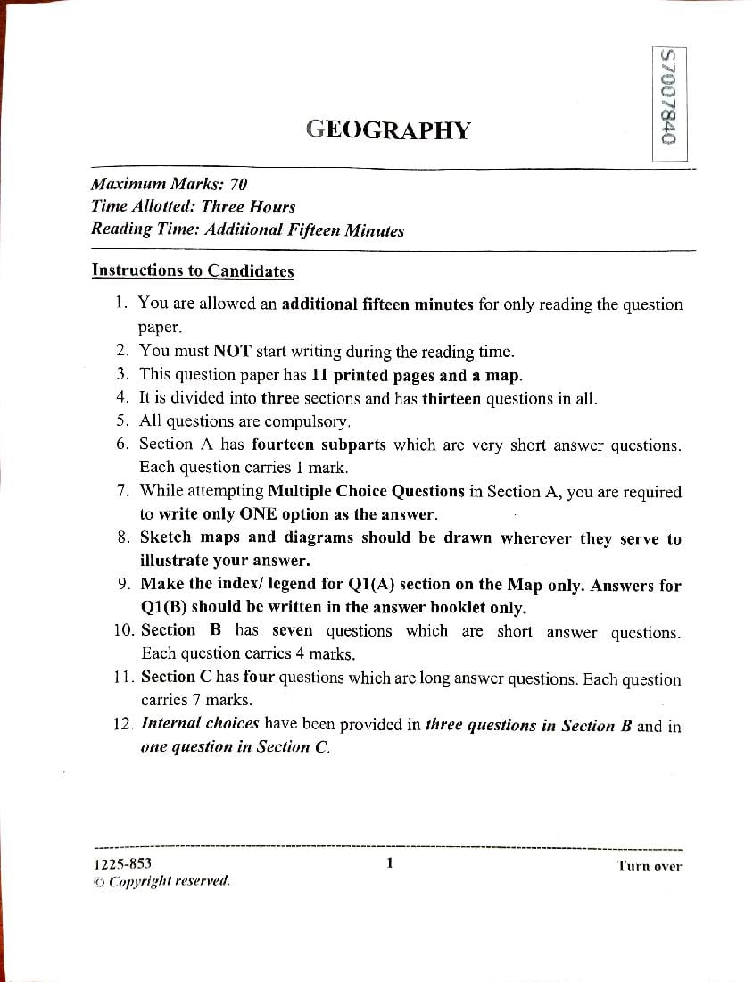
GEOGRAPHY
Maximum Marks: 70
Time Allotted: Three Hours
Reading Time: Additional Fifteen Minutes
Instructions to Candidates
1. Youare allowed an additional fifteen minutes for only reading the question
paper.
2. You must NOT start writing during the reading time.
3. This question paper has 11 printed pages and a map.
4. It isdivided into three sections and has thirteen questions in all.
5. All questions are compulsory.
6. Section A has fourteen subparts which are very short answer questions.
Each question carries 1 mark.
7. While attempting Multiple Choice Questions in Section A, you are required
to write only ONE option as the answer.
8. Sketch maps and diagrams should be drawn wherever they serve to
illustrate your answer.
9. Make the index/ legend for Q1(A)section on the Map only. Answers for
Q1(B) should be written in the answer booklet only.
10. Section B has seven questions which are short answer questions.
Each question carries 4 marks.
11. Section C has four questions which are long answer questions. Each question
carries 7 marks.
12. Internal choices have been provided in three questions inSection Band in
one question in Section C.
1225-853 1 Turn over
O Copyright reserved.
Page 2
1. Kindly read aloud the Instructions given on page 1 to all the candidates
present in the examination hall.
1225-853
Page 3
Question 1
A. Refer to the given outline Map of India and attempt subparts() and (ii)on
map only.
() Mark and label the following on the given outline Map of India. 3]
(a) The mountain range that lies between two west flowing rivers.
(b) The plateau which is the source of Damodar River.
(c) The narrovwwaterbody that separates India from Sri Lanka.
(ii) Label the following on the outline Map of India. [3)
(a) The oilrefinery marked A is
(b) The river markedS that flows through Himachal Pradesh and
Jammu and Kashmir is
(c) The most urbanised state marked T is
B. Refer to the given outline Map of India, identify the correct option and
write it in the answer booklet provided to you.
(i) The longitude of India markedP is: [1]
(a) 68°7'E
(b) 78°30'E
(c) 23°30'E
(d) 97°25'E
(ii) The port city marked Cthat has a sheltered backwater bay, is: [1]
(a) Mumbai
(b) Kochi
(c) Mangalore
(d) Marmagao
1225-853 3 Turn over
Page 4
(a) Kolkata
(b) Chandigarh
(c) Mumbai
(d) Delhi
(iv) The leading state producing groundnut marked R is:
(a) Karnataka
(b) Rajasthan
(c) Gujarat
(d) Andhra Pradesh
Question 2
Given beloware two statements marked Assertion and Reason. Read these statements
carefully and choose the correct option.
() Assertion: Thermal power stations are usually located near the coalfields. [1]
Reason: Transporting coal over short distance decreases the cost of production.
(a) Both Assertion and Reason are true and Reason is the correct explanation
for Assertion.
Both Assertion and Reason are true but Reason is not the correct
(b)
explanation for Assertion.
(c) Assertion is true and Reason is false.
(d) Both Assertion and Reason are false.
(ii) Assertion: Indian fishing industry is underdeveloped. [1)
Reason: The western coast is characterised by many indentations.
(a) Both Assertion and Reason are true and Reason is the correct explanation
for Assertion.
(b) Both ASsertion and Reason are true but Reason is not the correct
explanation for Assertion.
(c) Assertion is true and Reason is false.
(d) Both Assertion and Reason are false.
1225-853
Page 5
passengers as compared to railways.
Choose the correct reasons that justify the above statement.
(P) Roadways are a cheaper mode for short distance travel.
(Q) Heavy and bulky commodities can be carried on roadways.
(R) Roadways provide door to door services.
(S) The percentage of road accidents is less than rail accidents.
(a) Only (P) and ()
(b) Only (P) and (R)
(c) Only (Q) and (S)
(d) Only (R) and (S)
(iv) Observe the relation between the first two words and fill in the fourth word. [1]
Jowar : Maharashtra :: Bajra :
SECTION B-28 MARKS
Question 3
India is known as the 'Mistress of the Eastern Seas'. Justify the statement by [2]
giving wo reasons.
(ii) Distinguish between rivers Ganga and Godavarion each of the following bases: [2]
(a) Source of water supply
(b) Nature of flow
Question 4
() Rivers descending from the Himalayas deposit pebbles in a narrow belt of about [2]
8to 16 km in width parallel to the foothills of the Shiwaliks.
Identify the relief feature being indicated here. State one characteristic of this
feature, apart from the one indicated above.
5 Turn over
1225-853
Page 6
X
Question 5
(i) Coastal Odisha was battered by heavy winds and rain as Cyclone Dana,
classified as a severe cyclonic storm with wind speeds reaching up to 110 kmph,
made landfall between Bhitarkanika National Park and Dhamra shortly after
midnight on Thursday, 24 October 2024, the India Meteorological Department
(IMD) said.
(Source: www.hindustantimes.com)
(a)
What climatic conditions in India and its surrounding water bodies led to (2]
the phenomenon described above?
(b) Name twostates, other than the one mentioned above, that also experience [2]
the same phenomenon annually.
OR
(ii) Study the graph given below for Station A and answer the questions that follow.
35| 700
TEMPERATURE
°C
30
KEMPERATURE
600
500 IN
RAINFALL
MM
20 400
15 300
10 200
5 100
)
M A M J J A S O N D
(a) Provide a reason for the following:
(1) Low rainfall in themonths of June and July [1]
(2) High rainfall in the months of October and November |1]
(b) Does Station A experience a continental or a maritime climate? Give a (2]
reason for your answer.
1225-853 6
Page 7
over
years two reasons to
be
the (MILLIONS) POPULATION any
needs
during 1400 1200 1000 800 Give two
600 400 200
any
India. that
India 2011 Give
follow. IV capital
Phase of arguments.
in divide?
population
that
transition ! 1981 a
questions III demnographic as
but four
Phase the
demographic resource
giving
the 1951 in
change 7
answer II of by
Phase change.
year a
significant as statement
represents
and 1921 a viewed
carefully
II this called
Phase the
a for 1921 be
below 1901 indicates
account Justify
not
it yearfor
answer.
your
Study 1400 1200 1000 800 600 400 200 should
carefully.
given III to the
(MILLIONS) POPULATION
2011. reasons
Phase is
6Question Why Environment
7Question
graph
- managed
1225-853
The1901 () (ii)
Page 8
() Study the sketch map given below and answer the question that follows.
(2]
(a)
What type of migration is shown in the above map? Provide any one
reason for such type of migration.
(b) According to 2011 census, the sex ratio in India is 940. (21
Evaluate the reasons for the same.
OR
(ii) Answer the following questions.
(a) Jamshedpur is amillion plus city.Explain any one locational factor that [2]
contributed to its growth. Mention any one problem that this urban centre
encounters.
(b) Identify the pattern of settlement depicted below. Why does sucha pattern [2]
develop?
1225-853 8
Page 9
Contrast between Canal irrigation and Drip irrigation on anyfour bases.
OR
(ii) With the help of any two reasons, explain the importance of Mica in the electrical
industry of India. Which state leads in the production of thismineral? Name an
important centre of Mica production in the state named by you.
SECTION C- 28 MARKS
Question 10
Study the sketch map given below and answer the questions that follow.
() What has led to the establishment of the port marked P? Name any two industries [3]
that have led to its further growth.
(ii) State any four reasons for the development of a planning region like the one
shown above.
1225-853 Turn over
Page 10
() "ndian tourism promotes sustainable, responsible and inclusive development of
tourism in the country".
(www.hindustantimes. com)
(a) Why istourism recognised as a revenue generating industry? 14]
(b) What does the word responsible' imply in the context of tourism? (3]
State two ways in which responsible tourism is practised in India.
OR
(ii) The sketch map given below shows an important integrated steel plant of India,
developed in collaboration with erstwhile Soviet Union.
Jharia
River
Damodar
Birmitrapur Guru Mahisani
Badam Pahar
(a) Identify the integrated steel plant shown above. State its location. [2]
(b) Name the centres from where this steel plant procures the required coal (2]
and hydel power.
(c) State any three differences between the Integrated steel plant and the [3]
Ministeel plants.
1225-853 10
Page 11
(Source: www.sugiproject. com)
(i) Briefly explain any three impacts of the environmental movement, depicted [3]
above, on the Indian society.
(ii) State anyfour objectives of the National Forest Policy, 1988. |4]
Question 13
The Union Transport Minister Nitin Gadkari announced the introduction of a new
satellite based toll collection system. He said, We are putting an end to the present toll
system. Now there will be a satellite based toll collection system. Money will be
deducted from your bank account. You will be charged based on the total distance you
have travelled. Time will be saved and fuel will be saved."
(Source (edited): www.business-standard. com)
How will the development of the new satellite system, referred to above, [3]
accelerate industrialisation?
(ii) Discuss any four ways in which satellites have revolutionised the system of (4]
communication in India.
1225-853 11 Turn over
Page 12
108 24" 16°3
104"
00
96
96
92
answers)
MAP
OF
INDIA 92° 00
Km.
other
400
INDEX
NO.:
all
200
with
fastened 84 0Km. 84
for
Q.NO.1
Map
be
80
must
80
nap X
(This
769
120
R
UID
NO.:
720
P
64
60°
64 1225-8
56*
28 -20° 12°
-32°
Document Details
| Board / Org | CISCE |
| Exam | Class 12 |
| Type | Question Paper |
| Pages | 12 |
| Updated | 24 Sep 2026 |