UPSC CGGE 2016 Question Paper Hydrogeology
Finished viewing? Save it for later —
Download UPSC CGGE 2016 Question Paper Hydrogeology (PDF · 6 pages)About UPSC CGGE 2016 Question Paper Hydrogeology
UPSC CGGE 2016 Question Paper Hydrogeology is available here for free download. Published by UPSC for UPSC Combined Geo-Scientist, this question paper can be viewed online or downloaded as a PDF (6 pages). Candidates preparing for UPSC Combined Geo-Scientist can use UPSC CGGE 2016 Question Paper Hydrogeology to understand the exam pattern, the type of questions asked, and the overall difficulty level.
Frequently Asked Questions
How can I download UPSC CGGE 2016 Question Paper Hydrogeology?
Open this page and click the Download button to save UPSC CGGE 2016 Question Paper Hydrogeology as a PDF. It is completely free on AglaSem Docs.
Is UPSC CGGE 2016 Question Paper Hydrogeology free to download?
Yes. UPSC CGGE 2016 Question Paper Hydrogeology can be viewed online and downloaded as a PDF free of cost on AglaSem Docs.
How many pages does UPSC CGGE 2016 Question Paper Hydrogeology have?
UPSC CGGE 2016 Question Paper Hydrogeology contains 6 pages, which you can read online or download together as a single PDF.
Where can I find more UPSC Combined Geo-Scientist study material?
You can find more UPSC Combined Geo-Scientist question papers, sample papers, syllabus, and answer keys on AglaSem Docs.
UPSC CGGE 2016 Question Paper Hydrogeology – Text
Read the full text of this question paper below — useful to quickly search, copy and reference the content online without downloading the PDF.
📄 View text version (6 pages)
Page 1
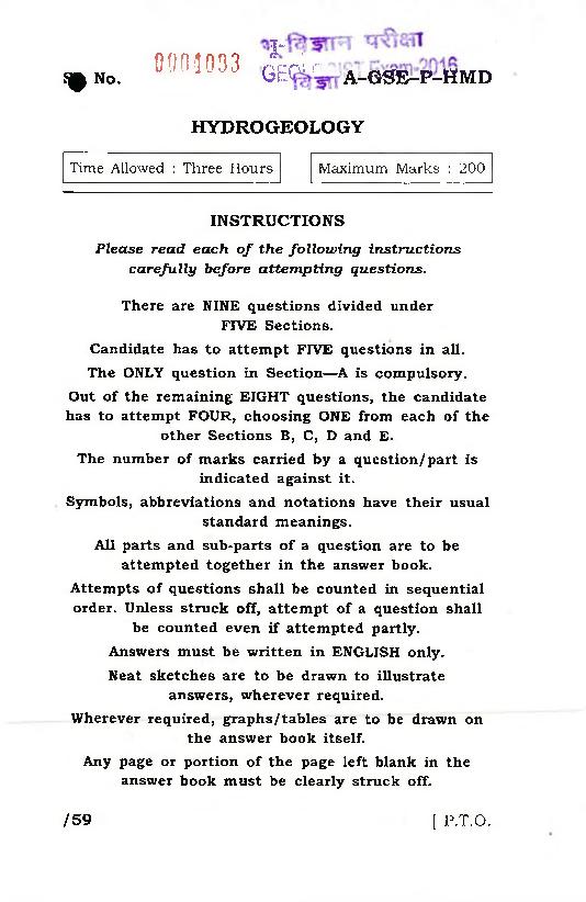
0034033 GEOLC a -G STE-P-H m d
.C
Q No.
HYDROGEOLOGY
Time Allowed : Three Hours Maximum Marks : 200
INSTRUCTIONS
Please read each o f the following instructions
carefully before attempting questions.
There are NINE questions divided under
FIVE Sections.
Candidate has to attem pt FIVE questions in all.
The ONLY question in Section— A is compulsory.
Out o f the rem aining EIGHT questions, the candidate
has to attempt FOUR, choosing ONE from each o f the
other Sections B, C, D and E.
The number of marks carried by a question/part is
indicated against it.
Symbols, abbreviations and notations have their usual
standard meanings.
All parts and sub-parts o f a question are to be
attempted together in the answer book.
Attempts o f questions shall be counted in sequential
order. Unless struck off, attem pt o f a question shall
be counted even if attempted partly.
Answers must be written in ENGLISH only.
Neat sketches are to be drawn to illustrate
answers, wherever required.
Wherever required, graphs/tables are to be drawn on
the answer book itself.
Any page or portion o f the page left blank in the
answer book must be clearly struck off.
/59 [ P.T.O.
Page 2
( Compulsory Section )
1. Write short notes on the following in not
more than 5 sentences each :
(a) Water balance concept 5
(b) Specific yield 5
(c) Drawdown in hydrogeology 5
(d) Steady-state groundwater flow condition 5
(e) Electromagnetic radiation 5
(fj SAR (Sodium Absorption Ratio) 5
(g) Radon gas in groundwater 5
(h) High-nitrate groundwater 5
S e c t io n — B
Attempt any on e question
2. (a) With a neat sketch, describe the vertical
distribution of groundwater. Write a
note on seasonal variation of ground
water level fluctuation. 15
A -G SE -P-H M D /59 2
Page 3
between confined aquifer and
unconfined aquifer. Write a note on
perched aquifer and its significance in
water supply schemes. 15
(c) Discuss the hydrological properties of
rocks. 10
3. (a) What are springs? How are springs
useful as a source of water supply? 15
(b) Explain the different types of springs
with special reference to hot springs. 15
(c) Write a note on the importance of
hydrographs. 10
S e c tio n — C
Attempt any one question
4. (a) Explain Darcy’s law. What is meant by
'hydraulic conductivity’ according to
Darcy’s law? 15
(b) Explain the ‘cone o f depression’ with
suitable illustrations. 15
(c) The thickness of an aquifer is found to
be 20 m. Its hydraulic conductivity is
20 cm/day. Calculate the transmis
sivity of the aquifer. 10
A-G SE-P-H M D /59 3 [ P.T.O.
Page 4
Contour Maps and Flow Net Analysis in
groundwater studies. 15
(b) Explain with neat sketches how
permeability is measured in the
laboratory. 15
(c) A confined aquifer is 35 m thick and
5 km wide. Two observation wells are
located 1-5 km apart in the direction of
groundwater flow. The head in well 1 is
100 m and in well 2 is 85 m. The
hydraulic conductivity is 2-5 m/day.
What is the daily flow of water through
the aquifer? 10
S e c t io n — D
Attempt any on e question
6. (a) Explain the principle involved in
electrical resistivity method of
groundwater exploration. 15
(b) Discuss the field procedure in
conducting electrical resistivity survey. 15
(c) Explain how electrical resistivity data
is interpreted using curve matching
technique in 2-layered cases. 10
A-G SE-P-H M D /59 4
Page 5
is done using different satellite images
and how they are useful in preparing
groundwater potential zone maps. 15
(b) Discuss how Geographic Information
System (GIS) is used in integrating
thematic maps. 15
(c) Explain the usefulness of resistivity
logging in delineation of aquifers and
quality of water. 10
Section— E
Attempt any one question
8. (a) What are the causes of saline water
intrusion into coastal aquifers? Explain
the Ghyben-Herzberg relationship
between saline water and freshwater. 15
(b) What are the possible geogenic sources
of fluoride in groundwater? Comment
briefly on the distribution of fluoride-
enriched groundwater in India. 15
(c) Discuss on the Pie diagram for
representing hydrogeochemical data. 10
A-G S E -P-H M D /59 5 [ P.T.O.
Page 6
suitability of groundwater for irrigation
purposes. Comment briefly on each of
them giving emphasis on their working
formula and suitability range. 15
(b) Discuss in brief on the use of Piper’s
trilinear diagram for determining the
groundwater quality. 15
(c) Explain the role of radio isotopes in
hydrogeological studies. 10
★ ★ ★
A-G SE-P-H M D /59 6 SB6— 4600
Document Details
| Board / Org | UPSC |
| Exam | UPSC Combined Geo-Scientist |
| Type | Question Paper |
| Pages | 6 |
| Updated | 30 Apr 2026 |