Karnataka 1st PUC Model Question Paper 2027 for Geography (Paper 1, Kannada Medium)
Finished viewing? Save it for later —
Download Karnataka 1st PUC Model Question Paper 2027 for Geography (Paper 1, Kannada Medium) (PDF · 6 pages)About Karnataka 1st PUC Model Question Paper 2027 for Geography (Paper 1, Kannada Medium)
Karnataka 1st PUC Model Question Paper 2027 for Geography (Paper 1, Kannada Medium) is available here for free download. Published by Karnataka Board for Class 11, this sample paper can be viewed online or downloaded as a PDF (6 pages). Candidates preparing for Class 11 can use Karnataka 1st PUC Model Question Paper 2027 for Geography (Paper 1, Kannada Medium) to understand the exam pattern, the type of questions asked, and the overall difficulty level.
Frequently Asked Questions
How can I download Karnataka 1st PUC Model Question Paper 2027 for Geography (Paper 1, Kannada Medium)?
Open this page and click the Download button to save Karnataka 1st PUC Model Question Paper 2027 for Geography (Paper 1, Kannada Medium) as a PDF. It is completely free on AglaSem Docs.
Is Karnataka 1st PUC Model Question Paper 2027 for Geography (Paper 1, Kannada Medium) free to download?
Yes. Karnataka 1st PUC Model Question Paper 2027 for Geography (Paper 1, Kannada Medium) can be viewed online and downloaded as a PDF free of cost on AglaSem Docs.
How many pages does Karnataka 1st PUC Model Question Paper 2027 for Geography (Paper 1, Kannada Medium) have?
Karnataka 1st PUC Model Question Paper 2027 for Geography (Paper 1, Kannada Medium) contains 6 pages, which you can read online or download together as a single PDF.
Where can I find more Class 11 study material?
You can find more Class 11 question papers, sample papers, syllabus, and answer keys on AglaSem Docs.
Karnataka 1st PUC Model Question Paper 2027 for Geography (Paper 1, Kannada Medium) – Text
Read the full text of this sample paper below — useful to quickly search, copy and reference the content online without downloading the PDF.
📄 View text version (7 pages)
Page 1
Karnataka 1st PUC Model
Question Paper 2027 for
Geography (Paper 1,
Kannada Medium)
EXAM YEAR TYPE SUBJECT
Karnataka Class 11 2027 Sample Paper Geography
Notes · Sample Papers · Previous Year Papers · Mock Tests
Page 2
m .co
m .co s e m
se g l a
ಕ್ಸಾಟಕ ಸ್ವಾಯ a
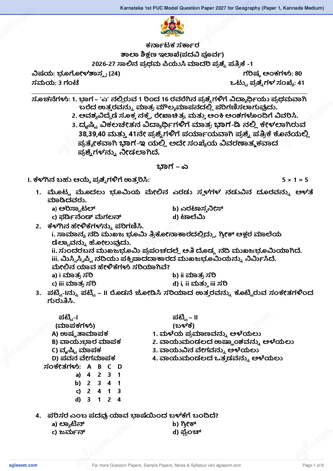
ಶಾಲಾ ಶಿ್ಷಣ ಇಲಾಖೆ(ದವಿ ಪೂರ್ಾ)
2026-27 ಸಾಲಿನ ರ ಥಭ ಪಿಯುಸಿ ಮಾದರಿ ರ ್ᥞೆ ್ರ ಕೆ -1
ವಿಷಮ: ಭೂಗೋಳಶಾಸ್ ರ (24) ಗರಿಷಠ ಅಂಕಗಳು: 80
ಸಭಮ: 3 ಗಂಟೆ ್ು ರ ್ᥞೆ ಗಳ ಸಂಖೆೆ : 41
____________________________________________________________________________________________________________
ಸೂಚನೆಗಳು: 1. ಭಾಗ – ʼಎʼ ನಲಿಿ ರುರ್ 1 ರಿಂದ 16 ಯರ್ರೆಗಿನ ರ ್ᥞೆ ಗಳಿಗೆ ವಿ್ಯೆ ್ᥕಾಯು ರ ಥಭವಾಗಿ
m
.co
ಫರೆದ ಉತ್್ ಯರ್್ನೆ ಮಾತ್ರ ಮೌಲ್ೆ ಮಾನದಲಿಿ ರಿಗಣಿಸಲಾಗುವುದು.
m
.co
2. ಅರ್ಶ್ೆ ವಿದೄೆ ಡೆ ಸೂಕ್ ನಕೆೆ , ರೇಖಾಚಿತ್ರ , ಭ್᥈್ ಅಂಕಿ ಅಂಶ್ಗಳಂದಿಗೆ ವಿರ್ರಿಸಿ.
e
3. ದೃ್ಿು ವಿಕಲ್ಚೇತ್ನ ವಿ್ಯೆ ್ᥕಾಗಳಿಗೆ ಮಾತ್ರ ಭಾಗ-ಡಿ ನಲಿಿ ಕೇಳಲಾಗಿರುರ್m
em ಭ್᥈್ 41ನೇ ರ ್ᥞೆ ಗಳಿಗೆ ್ಿಾಮವಾಗಿ ರ ್ᥞೆ ್ರ ಕೆ ಕೊನೆಮಲಿ
l asಿ
l as38,39,40
ರ ತ್ೆ ೋಕವಾಗಿ ಭಾಗ-ಇ ಮಲಿಿ ಅದ ಸಂಖೆೆ ಮ ವಿರ್ಯಣಾತ್ಮ ಕವಾದ ag
ag ರ ್ᥞೆ ಗಳ್ನೆ ನೋಡಲಾಗಿದೄ.
ಭಾಗ – ಎ
I. ಕೆಳಗಿನ ಫಹು ಆ್᥄ೆ ರ ್ᥞೆ ಗಳಿಗೆ ಉತ್್ ರಿಸಿ: 5×1=5
1. ಮಟು ಮದಲು ಭೂಮಿಮ ಮೇಲಿನ ಎಯಡು ಸಥ ಳಗಳ ನಡುವಿನ ದೂಯರ್್ನೆ ಅಳತ್
ಮಾಡಿದರ್ರು.
a) ಅರಿಸಾು ಟಲ್ b) ಎಯಟಾಸ್ ನೋಸ್
m
.co
c) ಪಡಿಾನೆಂಡ್ ಮೆಗಲ್ನ್ d) ಟಾಲೆಮಿ
ಕೆಳಗಿನ ಹೇಳಿಕೆಗಳ್ನೆ ರಿಗಣಿಸಿ.
m
2.
e
i. ಸಾಮಾನೆ ನದಿ ಮುಖಜ ಭೂಮಿ ್ರ ಕೊೋ್ಸ್ವಯದಲಿಿ ದುೆ , ಗಿರ ೋಕ್ ಅ್ಷಯ ಮಾಲೆಮ
s
ಡೆಲಾು ರ್್ನೆ ಹೋಲುವುದು.
g la
a
ii. ಸಂದಯಫನ ಮುಖಜಭೂಮಿ ರ ಪಂಚದಲೆಿ ಅ್ ದೊಡಡ ನದಿ ಮುಖಜಭೂಮಿ್ಿಗಿದೄ.
iii. ಮಿಸಿಿ ಸಿಿ ಪಿಿ ನದಿಯು ಕಿೆ ಪಾದ್ಯ್ವಯದ ಮುಖಜಭೂಮಿಮ್ನೆ ನಮಿಾಸಿದೄ.
ಮೇಲಿನ ್ಿರ್ ಹೇಳಿಕೆಗಳು ಸರಿ್ಿಗಿವೆ?
a) i ಮಾತ್ರ ಸರಿ b) ii ಮಾತ್ರ ಸರಿ
c) iii ಮಾತ್ರ ಸರಿ d) i, ii ಭ್᥈್ iii ಸರಿ
3. ್ಟು -I್ನೆ ್ಟು – II ರೊಡನೆ ಜೋಡಿಸಿ ಸರಿ್ಿದ ಉತ್್ ಯರ್್ನೆ ಕೊ್ಟು ರುರ್ ಸಂಕೇತ್ಗಳಿಂದ
ಗುರು್ಸಿ.
್ಟು -I ್ಟು – II m
m (ಮಾಕಗಳು) (ಫಳಕೆ) .co
m .co A) ಉಷಣ ತಾಮಾಕ 1. ಭಳೆಮ ರ ಮಾಣರ್್ನೆ ಅಳೆಮಲು
s e m
s e B) ವಾಯುಭಾಯ ಮಾಕ 2. ವಾಯುಮಂಡಲ್ದ ಉಷ್ಣ ಂಶ್ರ್್ನೆ ಅಳೆಮಲು
g l a
la
C) ವೃ್ಿು ಮಾಕ 3. ವಾಯುವಿನ ವೇಗರ್್ನೆ ಅಳೆಮಲು
g D) ರ್ನ ವೇಗಮಾಕ 4. ವಾಯುಮಂಡಲ್ದ ತ್್ ಡರ್್ನೆ ಅಳೆಮಲು a
a ಸಂಕೇತ್ಗಳು: A B C D
a) 4 2 3 1
b) 2 3 4 1
c) 2 4 1 3
d) 3 1 2 4
4. ರಿಸಯ ಎಂಫ ದವು ್ಿರ್ ಭಾಷೆಯಂದ ಫಳಕೆಗೆ ಬಂದಿದೄ?
a) ಲಾೆ ್ಟನ್ b) ಗಿರ ೋಕ್
m .
c) ಜಭಾನ್
.cod) ಫ್ರ ಂಚ್
s e m
s em l a
g la ag
a For more Question Papers, Sample Papers, Notes & Syllabus visit Page 1 of 6
Page 3
a) ಸಿಂಧೂ ನದಿ - ಸಟೆಿ ೋಜ್
b) ಕಾವೇರಿ ನದಿ - ಭೋಭ
c) ಮಹಾನದಿ - ಬವಾನ
d) ಗೋದಾವರಿ - ಸೋನ್
II. ಆರ್ಯಣದಲಿಿ ನೋಡಿರುರ್ ಸೂಕ್ ವಾದ ದರ್್ನೆ ಆರಿಸಿ ಬಿಟು ಸಥ ಳಗಳ್ನೆ ್᥈ಂಬಿರಿ: 5×1=5
(ಡಾಲ್ಡ ರ ಮ್, ಸರ್್ಸೆ , 3.6 ಬಿಲಿಮನ್ ರ್ಷಾಗಳು, ನತ್ೆ ಹರಿದವ ಣಾ, 4.6 ಬಿಲಿಮನ್
ರ್ಷಾಗಳು, ಮಾೆ ಕ್ಮೋಹನ್)
6. ಭೂಮಿಮ ಅಂ್ಯಜು ರ್ಮಸಿ _____________
7. ಸಭಭಾಜಕ ವೃತ್್ ದ ಕಡಿಮೆ ತ್್ ಡ ್ಟು ಮ್ನೆ _____________ ಎಂದು ಕರೆಯುರ್ರು.
8. ___________ ಜೋರ್ ಸಮೂಹಗಳು ಅಯಣೆ ಜೋರ್ ಸಮೂಹ ಭ್᥈್ ಹುಲುಿ ಗಾರ್ಲು ಜೋರ್
ಸಮೂಹಗಳ ಭಧೆ ರ್್ಾ ಸಥ ಳಗಳಲಿಿ ಕಂಡುಫರುತ್್ ವೆ.
9. ಭಾಯತ್ ಭ್᥈್ ಚಿೋ್ಸ ನಡುವಿನ ಅಂತ್ರಾ್ಿು ರ ೋಮ ಗಡಿರೇಖೆ ____________
10. _____________ ಅಯಣೆ ಗಳು ಅ್ ಹೆ್ᤴು ಭಳೆ ಭ್᥈್ ಉಷಣ ತ್ ಹಂದಿರುರ್ ರ ದಶ್ಗಳಲಿಿ
ಕಂಡುಫರುತ್್ ವೆ
III. ಕೆಳಗಿನವುಗಳ್ನೆ ಹಂದಿಸಿ ಫರೆಯರಿ: 1×5=5
11. ಎ ಬಿ
a) ಅಣು ಖನಜ I. ಸಣಣ ದಕಲುಿ ರ ದಶ್
b) ಅಂತ್ಜಾಲ್ II. ಮಜಂಬಿಕ್ ರ ವಾಹ
c) ವಿಲಿಿ ವಿಲಿಿ III. ಯುರೇನಯಂ
d) ಕ್ಸಾಟಕ ಭ್᥈್ ಗೋವಾ IV. ಸೋಮಾಲಿ್ಿ ರ ವಾಹ
e) ಉತ್್ ಯ ಹಂದೂ ಭಹಾಸಾಗಯ V. ಮಾಂಡೋವಿ ಜಲ್ ವಿವಾದ
VI. ಆ್ᥗು ರ ೋಲಿ್ಿ
IV. ಕೆಳಗಿನ ರ ್ᥞೆ ಗಳಿಗೆ ಂದು ದ ಅಥವಾ ಂದು ವಾಕೆ ದಲಿಿ ಉತ್್ ರಿಸಿ: 5×1=5
12. IDL ವಿಸ್ ರಿಸಿ.
13. ಭೂ ವಿರೂಣೆಮ್ನೆ ಅ್ᥕಾಸಿ.
14. ವಾಯುಮಂಡಲ್ದಲಿಿ ಇಂಗಾಲ್ದ ಡೈ ಆಕೆಿ ೈಡ್ ಏಕೆ ಭಹತ್ವ ಡೆದಿದೄ?
15. ಉಫಬ ಯವಿಳಿತ್ಗಳು ಹೇಗೆ ಉಂಟಾಗುತ್್ ವೆ?
16. ಫಯಗಾಲ್ರ್್ನೆ ವಾೆ ಖಾೆ ನಸಿ.
ಭಾಗ – ಬಿ
V. ಕೆಳಗಿನ ್ಿವು್ಯದರೂ ಐದು ರ ್ᥞೆ ಗಳಿಗೆ 2 ರಿಂದ 3 ವಾಕೆ ಗಳಲಿಿ ಉತ್್ ರಿಸಿ: 5 × 2 = 10
17. ್ಸವೆಾ ದಶ್ರ್್ನೆ “ಭಧೆ ರಾ್ರ ಮ ಸೂಮಾನ ್ಸಡು” ಎಂದು ಏಕೆ ಕರೆಯುರ್ರು?
18. ಅಂತ್ಸಿ ಯಣ ಭ್᥈್ ಫಹಸಿ ಯಣ ಅಗಿೆ ಶಿಲೆಗಳಿಗಿರುರ್ ರ್ೆ ತಾೆ ಸಗಳ್ನೆ ್ಳಿಸಿ.
19. ಜೈವಿಕ ಶಿ್ᥕಲಿೋಕಯಣ ಹೇಗೆ ಉಂಟಾಗುತ್್ ದೄ?
20. ಸಾಗಯದ ನೋರಿನ ಚಲ್ನೆಗಳ್ನೆ ್ಳಿಸಿ.
21. ಜೋರ್ಗೋಳದ ವಿವಿಧ ಘಟಕಗಳು ್ಿವುವು?
22. ಭಾಯತ್ದ ಅ್ವೆ ಂಶ್ ಭ್᥈್ ರೇಖಾಂಶ್ಗಳ ವಿಸ್ ಯಣೆಮ್ನೆ ಫರೆಯರಿ.
23. ನದಿಗಳ ಅಂತರ್ ಜೋಡಣೆಯ ಅವಶ್ಯ ಕತೆಯೇನು?
24. ಜೈವಿಕ ಸಂಯ್ಷಣಾ ರ ದಶ್ಗಳೆಂದರೇ್ನ?
ಭಾಗ – ಸಿ
VI. ಕೆಳಗಿನ ್ಿವು್ಯದರೂ ಏಳು ರ ್ᥞೆ ಗಳಿಗೆ 20 ರಿಂದ 25 ವಾಕೆ ಗಳಲಿಿ ಉತ್್ ರಿಸಿ: 7 × 5 = 35
25. ಭೂಗೋಳಶಾಸ್ ರ ದ ರ ಮುಖ ಶಾಖೆಗಳ್ನೆ ವಿರ್ರಿಸಿ.
26. ಭೂಮಿಯು ಗೋಳಾ್ವಯದಲಿಿ ದೄ ಎಂಬುದ್ನೆ ನರೂಪಿಸರ್ ನದಶ್ಾನಗಳ್ನೆ ಕುರಿ್᥈
ಫರೆಯರಿ.
27. ಭೂಮಿಮ ಯಚನೆ ಭ್᥈್ ಸಂಯೋಜನೆಮ್ನೆ ಚಿತ್ರ ಸಹತ್ ವಿರ್ರಿಸಿ.
For more Question Papers, Sample Papers, Notes & Syllabus visit Page 2 of 6
Page 4
m .co
28. ರ ಪಂಚದ ಭೂಕಂ ರ್ಲ್ಮಗಳ್ನೆ ಸಂಕಿೆ ್ ವಾಗಿ ವಿರ್ರಿಸಿ.
m .co 29. ನದಿಮ ಸವೆತ್ ್ವಮಾದಿಂ್ಯದ ಭೂ ಸವ ರೂಗಳ್ನೆ ರ್ಣಾನೆ ನೋಡಿರಿ.
s e m
se
30. ವಾಯುಮಂಡಲ್ದ ಯಚನೆಮ್ನೆ ವಿರ್ರಿಸಿ.
31. ನರಂತ್ಯ ಮಾರುತ್ಗಳು ಎಂದರೇ್ನ? ನರಂತ್ಯ ಮಾರುತ್ದ ವಿಧಗಳ್ನೆ ವಿರ್ರಿಸಿ. g l a
32. ಸಾಗಯದ ನೋರಿನ ಲ್ರ್ಣತ್ಮ ಮೇಲೆ ರ ಭಾರ್ ಬಿೋರಿರುರ್ ಅಂಶ್ಗಳಾವುವು? a
33. ಹಮಾಲ್ಮದ ಭಹತ್ವ ರ್್ನೆ ಕುರಿ್᥈ ್ಟು ಮಾಡಿ, ಸಾರಾಂಶ್ನೋಡಿ.
34. ಉತ್್ ಯ ಭಾಯತ್ದ ನದಿಗಳು ಭ್᥈್ ದಕಿೆ ಣ ಭಾಯತ್ದ ನದಿಗಳ ನಡುವಿನ ರ್ೆ ತಾೆ ಸಗಳ್ನೆ
ಹೋಲಿಸಿ ಫರೆಯರಿ.
35. ಭಾಯತ್ದ ರ ಮುಖ ಭಣಿಣ ನ ರ ್ವಯಗಳ್ನೆ ಕುರಿ್᥈ ಫರೆಯರಿ.
36. ಅಯಣೆ ಸಂಯ್ಷಣೆಮ ರ ಮುಖ ರಿಹಾರೊೋಪಾಮಗಳ್ನೆ ವಿರ್ರಿಸಿ.
37. ಭಾಯತ್ದಲಿಿ ಕಡಲ್ ಕೊರೆತ್ರ್್ನೆ ಕುರಿ್᥈ ್ಟಿ ಣಿ ಫರೆಯರಿ.
ಭಾಗ – ಡಿ
o m
m . c
VII. (A) ಕೆಳಗಿನ ್ಿವು್ಯದರೂ
. co ಂದು ರ ್ᥞೆ ಗೆ ಉತ್್ ರಿಸಿ: 1× 5 = m
s e 5
s em ಕ ಅಂಶ್ಗಳ್ನೆ
38. ನಕೆೆ ಮ ಅರ್ಶ್ೆ ವಿರ್ರಿಸಿ.
g l a
l a
39. ಸೂಚಿ ಎಂದರೇ್ನ? ್ಿವು್ಯದರು ್ಸಲುೆ ಭೌಗೋಳಿಕ ಚಿನೆೆ ಗಳ್ನೆ ಫರೆದು ಹೆಸರಿಸಿ.
g ರ ್ᥞೆ ಗೆ ಉತ್್ ರಿಸಿ: a
a
VII. (B) ಕೆಳಗಿನ
40. ಕ್ᥘಾಟಕದ ನ್᥌ೆ ಯ್ᥤಿ
2× 5=10
ಗುರುತಿಸಿರುವ ಈ ್᥌ಳಕಂಡ ಸ್ಥ ಳಗಳ ಅಕಾೆ ಂಶ್ ಮ್᥈ು
ರೇಖಂಶ್ಗಳನುು ಗುರುತಿಸಿ ಬರೆಯಿರಿ.
a) ಬಂಗಳೂರು
b) ಮೈಸೂರು
c) ಮಂಗಳೂರು
d) ಹಾವೇರಿ
m
.co
e) ಬೋದರ್
e m
las
ag
41. ಭಾರತದ ರೇಖ ನ್᥌ೆ ಯನುು ರಚಿಸಿ ್᥌ಳಗಿನವುಗಳನುು ಗುರುತಿಸಿ ಮ್᥈ು ಹೆಸ್ರಿಸಿ
(ನಕಾೆ ರಚನೆ - 2 ಅಂಕಗಳು, ಸ್ಥ ಳಗಳನುು ಗುರುತಿಸಿ ಮ್᥈ ಹೆಸ್ರಿಸ್ಲು-3 ಅಂಕಗಳು) m
m a) ಪೂವಾ ಘಟಟ ಗಳು
.co
m .co b) 231/20 ಕಕಾಾಟಕ ಸಂಕಾಾ ತಿವೃತು
s e m
s e c) ಪೋರ್ಾಬಿ ೋರ್
g l a
g la ಭಾಗ – ಇ a
a
(ದೃ್ಿು ವಿಕಲ್ಚೇತ್ನ ವಿ್ಯೆ ್ᥕಾಗಳಿಗೆ ಮಾತ್ರ )
VII. (A) ಕೆಳಗಿನ ್ಿವು್ಯದರೂ ಂದು ರ ್ᥞೆ ಗೆ 20 ರಿಂದ 25 ವಾಕೆ ಗಳಲಿಿ ಉತ್್ ರಿಸಿ: 1× 5 = 5
38. ಭಾಯತ್ದ ಕರಾರ್ಳಿ ಮೈ್ಯನಗಳ್ನೆ ಸಂಕಿೆ ್ ವಾಗಿ ವಿರ್ರಿಸಿ.
39. ನೈರುತ್ೆ ಮಾ್ಸಿ ನ್ ಮಾರುತ್ಗಳ ್ವಲ್ದ ವಿರ್ಯಣೆ ನೋಡಿ.
om .
VII. (B) ಕೆಳಗಿನ ರ ್ᥞೆ ಗೆ ಉತ್್ ರಿಸಿ: 2× 5 = 10
.c
40. ಭಣಿಣ ನ ಸವೆತ್ಕೆೆ ್ವಯಣಗಳ್ನೆ ್ಳಿಸಿ ಭ್᥈್ ಸಂಯ್ಷಣೆಮ ಕರ ಭಗಳ್ನೆ ವಿರ್ರಿಸಿ. e m
em
41. ನೈಸಗಿಾಕ ವಿಕೊೋ ಭ್᥈್ ವಿ್ಸಶ್ಗಳ ರಿಣಾಭಗಳ್ನೆ ್ಟು ಮಾಡಿ ವಿ್ᥞಿ ೋ್ಿಸಿ.
l as
las **************
ag
ag For more Question Papers, Sample Papers, Notes & Syllabus visit Page 3 of 6
Page 5
DEPARTMENT OF SCHOOL EDUCATION (PRE UNIVERSITY)
2026-27 I PUC MODEL QUESTION PAPER-1
Subject: GEOGRAPHY (24) Max. Marks: 80
Time: 3 hours No. of Questions: 41
_______________________________________________________________________________
Instructions:
1. For question no. 1 to 16 from PART – A, only the first written answer by the students will
be considered for evaluation.
2. Please substantiate your answer with suitable map, diagram and data etc.,
3. For question no.38, 39, 40 and 41 from PART-D, alternative questions with same number
are given at the end of the question paper in PART-E only for VISUALLY CHALLENGED
STUDENTS.
PART – A
I. Answer the following multiple-choice questions: 5×1=5
1. The distance between places on the Earth was first calculated by .
a) Aristotle b) Eratosthenes
c) Ferdinand Magellan d) Ptolemy
2. Consider the following statements.
i) common Delta triangular in shape resembles Greek letter Delta
ii) The Sundarban Delta is the largest delta in the world.
iii) River Mississippi formed bird foot Delta.
which of the above statements are correct?
a) i only correct b) ii only correct
c) iii only correct d) i, ii and iii are correct.
3. Match List-I with List-II and identify the correct answer from codes given below.
List-I List-II
(Instruments) (Uses)
A. Thermometer 1. Measuring amount of Rainfall
B. Barometer 2. Measuring atmospheric temperature
C. Rain gauge 3. Measuring wind speed
D. Anemometer 4. Measuring atmospheric pressure
Codes: A B C D
a) 4 2 3 1
b) 2 3 4 1
c) 2 4 1 3
d) 3 1 2 4
4. The word environment is derived from which language?
a) Latin b) Greek
c) German d) French
5. With reference to main river and their tributaries Choose the correct pair.
a) Indus River - Sutluj
b) Kaveri River - Bhima
c) Mahanadi - Bhavani
d) Godavari - Son
For more Question Papers, Sample Papers, Notes & Syllabus visit Page 4 of 6
Page 6
m .co
c. o II. Fill in the blanks by choosing the appropriate words givensinemthe bracket. 5×1=5
m la years, Mc Mahon)
se g
(Doldrums, Savanna, 3.6 billion years, Evergreen, 4.6 billion
a
6. The Approximate Age of the Earth _________________
7. Equatorial low-pressure belt is known as _____________
8. _________ Biome is the transitional biome between the forest biome and grassland biome.
9. The international boundary between India and China is____________
10. __________ Forests are found in areas with high rainfall and high temperature.
III. Match the following 1×5=5
11. A B
m
a) Atomic mineral
m i. Limestone Region
.co
m
c) Willy willies .co
b) Under Ground Water ii. Mozambique current
iii. Uranium s e m
s e l a
ag
d) Karnataka and Goa iv. Somalia current
g l a
e) North Indian Ocean v. Mandavi water dispute
a vi. Australia
IV. Answer the following questions in a word or a sentence. 5×1=5
12. Expand IDL.
13. Define Diastrophism.
14. Why is Carbon dioxide important in the Atmosphere?
15. How does a tide occur?
16. Define drought?
PART – B
m
V. Answer any FIVE of the following questions in 2 to 3 sentences.
m .co 5 × 2 = 10
e
17. Why Norway called ' The Land of Mid-night Sun'?
s
la
18. Distinguish between intrusive and extrusive rocks.
ag
19. How does Biological Weathering take place?
20. List out types of ocean water movements.
21. What are the components of biosphere?
22. Write the latitudinal and longitudinal extent of India.
23. What is the necessity of Inter-linking of Rivers?
24. What are the biosphere reserves?
PART – C
VI. Answer any SEVEN of the following questions in 20 to 25 sentences. 7 × 5 = 35
o m
25. Explain the important branches of geography.
m . c
c. o 26. Explain the proofs in support of the spherical shape of the Earth.
s e m
em
27. Explain the structure and composition of the earth with a diagram.
s 28. Briefly explain the seismic zones.
g l a
g la 29. Describe the Landforms Associated with the Erosional work of River. a
a 30. Explain the structure of the Atmosphere.
31. What are planetary winds? Explain the types of planetary winds.
32. Describe the salient features of Salinity of the Ocean water.
33. List out and summaries the significance of Himalaya.
34. Compare and write the differences between North Indian rivers and South Indian rivers.
35. Write about the major types of soils in India.
36. Explain the measures of forest conservation.
37. Write a note on coastal erosion of India.
m .
.co s e m
s em l a
g la ag
a For more Question Papers, Sample Papers, Notes & Syllabus visit Page 5 of 6
Page 7
VII.(A) Answer any ONE of the following questions: 1× 5 = 5
38. Explain the essential elements of a map.
39. What is an index? Write and name any four geographical symbols.
VII.(B) Answer the following question: 2× 5 = 10
40. Identify and write the latitude and longitude of the following places marked on the map of
Karnataka.
a) Bangalore
b) Mysore
c) Mangalore
d) Haveri
e) Bidar
41. Draw an outline map of India, locate and name the following̤.
(Map drawing - 2 marks, locating and naming of places - 3 marks)
a) Eastern Ghats
b) 231/20 Tropic of Cancer
c) Port Blair
PART -E
(FOR VISUALLY CHALLENGED STUDENTS ONLY)
VII.(A) Answer any ONE of the following questions in 20 to 25 sentences: 1× 5 = 5
38. Briefly explain the Coastal plains of India.
39. Give details the south west monsoon season.
VII.(B) Answer the following question: 2× 5 = 10
40. Mention the causes for soil erosion and explain the measures of soil erosion.
41. List out and analyze the consequences natural hazards and disasters.
*****
For more Question Papers, Sample Papers, Notes & Syllabus visit Page 6 of 6
Document Details
| Board / Org | Karnataka Board |
| Exam | Class 11 |
| Type | Sample Paper |
| Pages | 6 |
| Updated | 13 Nov 2026 |