Maharashtra 10th Std Model Question Paper 2027 Geography
Finished viewing? Save it for later —
Download Maharashtra 10th Std Model Question Paper 2027 Geography (PDF · 3 pages)About Maharashtra 10th Std Model Question Paper 2027 Geography
Maharashtra 10th Std Model Question Paper 2027 Geography is available here for free download. Published by Maharashtra Board for Class 10, this sample paper can be viewed online or downloaded as a PDF (3 pages). Candidates preparing for Class 10 can use Maharashtra 10th Std Model Question Paper 2027 Geography to understand the exam pattern, the type of questions asked, and the overall difficulty level.
Frequently Asked Questions
How can I download Maharashtra 10th Std Model Question Paper 2027 Geography?
Open this page and click the Download button to save Maharashtra 10th Std Model Question Paper 2027 Geography as a PDF. It is completely free on AglaSem Docs.
Is Maharashtra 10th Std Model Question Paper 2027 Geography free to download?
Yes. Maharashtra 10th Std Model Question Paper 2027 Geography can be viewed online and downloaded as a PDF free of cost on AglaSem Docs.
How many pages does Maharashtra 10th Std Model Question Paper 2027 Geography have?
Maharashtra 10th Std Model Question Paper 2027 Geography contains 3 pages, which you can read online or download together as a single PDF.
Where can I find more Class 10 study material?
You can find more Class 10 question papers, sample papers, syllabus, and answer keys on AglaSem Docs.
Maharashtra 10th Std Model Question Paper 2027 Geography – Text
Read the full text of this sample paper below — useful to quickly search, copy and reference the content online without downloading the PDF.
📄 View text version (3 pages)
Page 1
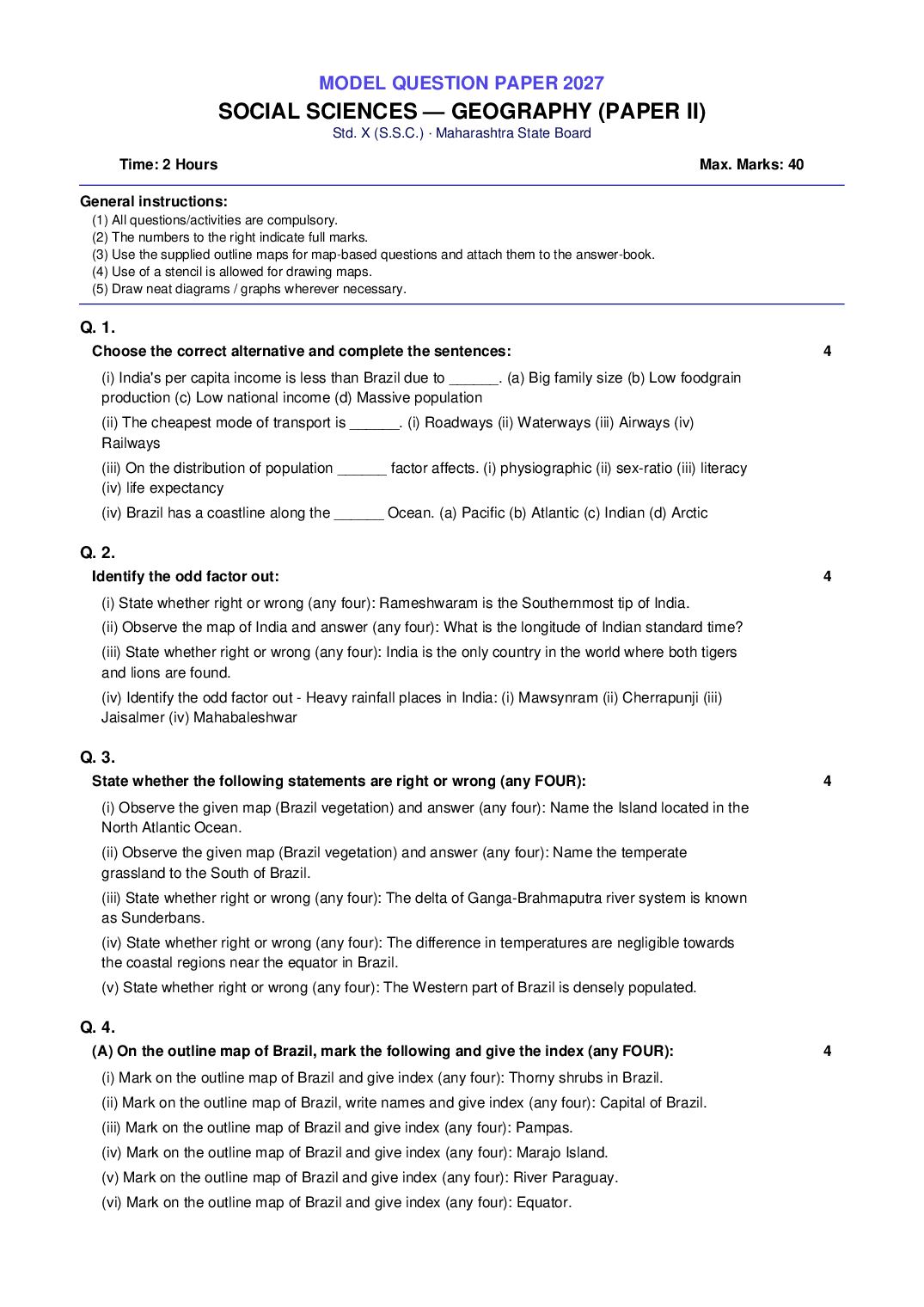
SOCIAL SCIENCES — GEOGRAPHY (PAPER II)
Std. X (S.S.C.) · Maharashtra State Board
Time: 2 Hours Max. Marks: 40
General instructions:
(1) All questions/activities are compulsory.
(2) The numbers to the right indicate full marks.
(3) Use the supplied outline maps for map-based questions and attach them to the answer-book.
(4) Use of a stencil is allowed for drawing maps.
(5) Draw neat diagrams / graphs wherever necessary.
Q. 1.
Choose the correct alternative and complete the sentences: 4
(i) India's per capita income is less than Brazil due to ______. (a) Big family size (b) Low foodgrain
production (c) Low national income (d) Massive population
(ii) The cheapest mode of transport is ______. (i) Roadways (ii) Waterways (iii) Airways (iv)
Railways
(iii) On the distribution of population ______ factor affects. (i) physiographic (ii) sex-ratio (iii) literacy
(iv) life expectancy
(iv) Brazil has a coastline along the ______ Ocean. (a) Pacific (b) Atlantic (c) Indian (d) Arctic
Q. 2.
Identify the odd factor out: 4
(i) State whether right or wrong (any four): Rameshwaram is the Southernmost tip of India.
(ii) Observe the map of India and answer (any four): What is the longitude of Indian standard time?
(iii) State whether right or wrong (any four): India is the only country in the world where both tigers
and lions are found.
(iv) Identify the odd factor out - Heavy rainfall places in India: (i) Mawsynram (ii) Cherrapunji (iii)
Jaisalmer (iv) Mahabaleshwar
Q. 3.
State whether the following statements are right or wrong (any FOUR): 4
(i) Observe the given map (Brazil vegetation) and answer (any four): Name the Island located in the
North Atlantic Ocean.
(ii) Observe the given map (Brazil vegetation) and answer (any four): Name the temperate
grassland to the South of Brazil.
(iii) State whether right or wrong (any four): The delta of Ganga-Brahmaputra river system is known
as Sunderbans.
(iv) State whether right or wrong (any four): The difference in temperatures are negligible towards
the coastal regions near the equator in Brazil.
(v) State whether right or wrong (any four): The Western part of Brazil is densely populated.
Q. 4.
(A) On the outline map of Brazil, mark the following and give the index (any FOUR): 4
(i) Mark on the outline map of Brazil and give index (any four): Thorny shrubs in Brazil.
(ii) Mark on the outline map of Brazil, write names and give index (any four): Capital of Brazil.
(iii) Mark on the outline map of Brazil and give index (any four): Pampas.
(iv) Mark on the outline map of Brazil and give index (any four): Marajo Island.
(v) Mark on the outline map of Brazil and give index (any four): River Paraguay.
(vi) Mark on the outline map of Brazil and give index (any four): Equator.
Page 2
(i) Observe the given map (Brazil vegetation) and answer (any four): What does the map show?
(ii) Observe the given map (Brazil vegetation) and answer (any four): Name the river that flows
through Caatinga.
(iii) Identify the odd factor out - States in Brazil: (i) Sao Paulo (ii) Parana (iii) Bahia (iv) Uruguay
(iv) Identify the odd factor out - Major trading partners of Brazil: (i) China (ii) Germany (iii) USA (iv)
Canada
(v) State whether right or wrong (any four): Naldurg is a hill fort.
Q. 5.
Give geographical reasons (any TWO): 6
(i) Give geographical reasons (any two): There is mixed economy in Brazil and India.
(ii) Give geographical reasons (any two): Himalayan rivers are perennial in nature.
(iii) Give geographical reasons (any two): Snowfall doesn't always occur in Brazil.
(iv) Give geographical reasons (any two): Settlements are sparse in North-Eastern Brazil.
Q. 6.
Draw a graph / read the given graph and answer the questions (any ONE): 6
(i) With the help of given statistical data, prepare a simple line graph and answer: Brazil -
Percentage of Urban Population (1960 to 2010). Data - 1960:47.1, 1970:56.8, 1980:66.0,
1990:74.6, 2000:81.5, 2010:84.6. Questions: (1) What is the interval of the data? (2) What was the
increase in percentage of urban population from 2000 to 2010? (3) Which year shows the least
urbanisation?
(ii) Observe the figure (India and Brazil - contribution of sectors in GDP and population engaged)
and answer: (1) Which country has a higher percentage of population engaged in primary activities?
(2) In which country is the contribution of tertiary sector greater in GDP? (3) In which country is the
share of secondary activities more in the GDP? (4) In which sector is the maximum percentage of
population engaged in Brazil? (5) How much more is Brazil's contribution in tertiary sector in GDP
as compared to India? (6) How much percentage of population is engaged in tertiary sector in India?
Q. 7.
Answer in detail (any TWO): 8
(i) Answer in detail (any two): What is field visit? State its importance.
(ii) Answer in detail (any two): What preparations would you make before going for the field visit?
Prepare a questionnaire to visit a weather station.
Page 3
respect to the climate of India.
This is a model / practice paper built by AglaSem from an analysis of past MSBSHSE board papers. It follows the current board pattern for practice
purpose only.
Document Details
| Board / Org | Maharashtra Board |
| Exam | Class 10 |
| Type | Question Paper |
| Pages | 3 |
| Language | english |
| Updated | 24 Sep 2026 |