Karnataka 1st PUC Model Question Paper 2027 for Geography (Paper 2, Kannada Medium)
Finished viewing? Save it for later —
Download Karnataka 1st PUC Model Question Paper 2027 for Geography (Paper 2, Kannada Medium) (PDF · 6 pages)About Karnataka 1st PUC Model Question Paper 2027 for Geography (Paper 2, Kannada Medium)
Karnataka 1st PUC Model Question Paper 2027 for Geography (Paper 2, Kannada Medium) is available here for free download. Published by Karnataka Board for Class 11, this sample paper can be viewed online or downloaded as a PDF (6 pages). Candidates preparing for Class 11 can use Karnataka 1st PUC Model Question Paper 2027 for Geography (Paper 2, Kannada Medium) to understand the exam pattern, the type of questions asked, and the overall difficulty level.
Frequently Asked Questions
How can I download Karnataka 1st PUC Model Question Paper 2027 for Geography (Paper 2, Kannada Medium)?
Open this page and click the Download button to save Karnataka 1st PUC Model Question Paper 2027 for Geography (Paper 2, Kannada Medium) as a PDF. It is completely free on AglaSem Docs.
Is Karnataka 1st PUC Model Question Paper 2027 for Geography (Paper 2, Kannada Medium) free to download?
Yes. Karnataka 1st PUC Model Question Paper 2027 for Geography (Paper 2, Kannada Medium) can be viewed online and downloaded as a PDF free of cost on AglaSem Docs.
How many pages does Karnataka 1st PUC Model Question Paper 2027 for Geography (Paper 2, Kannada Medium) have?
Karnataka 1st PUC Model Question Paper 2027 for Geography (Paper 2, Kannada Medium) contains 6 pages, which you can read online or download together as a single PDF.
Where can I find more Class 11 study material?
You can find more Class 11 question papers, sample papers, syllabus, and answer keys on AglaSem Docs.
Karnataka 1st PUC Model Question Paper 2027 for Geography (Paper 2, Kannada Medium) – Text
Read the full text of this sample paper below — useful to quickly search, copy and reference the content online without downloading the PDF.
📄 View text version (7 pages)
Page 1
Karnataka 1st PUC Model
Question Paper 2027 for
Geography (Paper 2,
Kannada Medium)
EXAM YEAR TYPE SUBJECT
Karnataka Class 11 2027 Sample Paper Geography
Notes · Sample Papers · Previous Year Papers · Mock Tests
Page 2
m .co
m .co s e m
se g l a
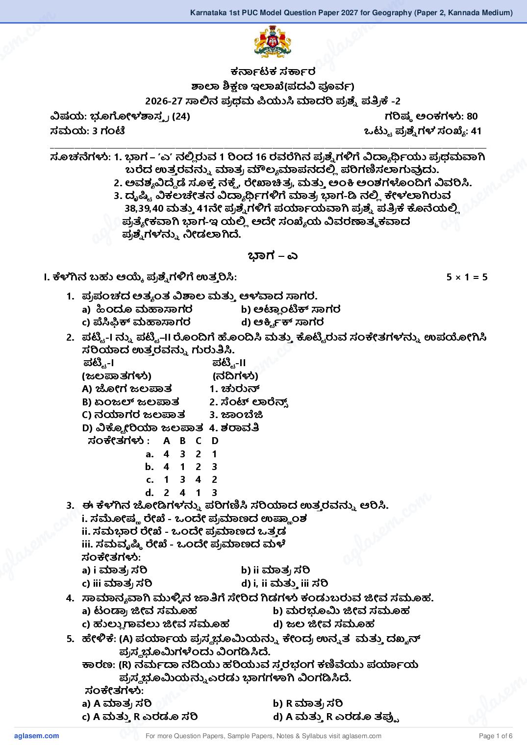
ಕ್ಸಾಟಕ ಸ್ವಾರ a
ಶಾಲಾ ಶಿ್ಷಣ ಇಲಾಖೆ(ದವಿ ಪೂರ್ಾ)
2026-27 ಸಾಲಿನ ರ ಥಮ ಪಿಯುಸಿ ಮಾದರಿ ರ ್ಾೆ ್ರರ ಕೆ -2
ವಿಷಯ: ಭೂಗೋಳಶಾಸ್ ರ (24) ಗರಿಷಠ ಅಂಕಗಳು: 80
ಸಮಯ: 3 ಗಂಟೆ ್ು ರ ್ಾೆ ಗಳ ಸಂಖೆೆ : 41
____________________________________________________________________________________________________________
ಸೂಚನೆಗಳು: 1. ಭಾಗ – ʼಎʼ ನಲಿಿ ರುರ್ 1 ರಿಂದ 16 ರರ್ರೆಗಿನ ರ ್ಾೆ ಗಳಿಗೆ ವಿ್ಯೆ ್ᥕಾಯು ರ ಥಮವಾಗಿ
m
.co
ಬರೆದ ಉತ್್ ರರ್್ನೆ ಮಾತ್ರ ಮೌಲ್ೆ ಮಾನದಲಿಿ ರಿಗಣಿಸಲಾಗುವುದು.
m
.co
2. ಅರ್ಶ್ೆ ವಿದೄೆ ಡೆ ಸೂಕ್ ನಕೆೆ , ರೇಖಾಚಿತ್ರ , ಮ್᥈್ ಅಂಕಿ ಅಂಶ್ಗಳಂದಿಗೆ ವಿರ್ರಿಸಿ.
3. ದೃ್ಿು ವಿಕಲ್ಚೇತ್ನ ವಿ್ಯೆ ್ᥕಾಗಳಿಗೆ ಮಾತ್ರ ಭಾಗ-ಡಿ ನಲಿಿ ಕೇಳಲಾಗಿರುರ್ e m
e m
38,39,40 ಮ್᥈್ 41ನೇ ರ ್ಾೆ ಗಳಿಗೆ ್ಿಾಯವಾಗಿ ರ ್ಾೆ ್ರರ ಕೆ ಕೊನೆಯಲಿಿ
l as
l asರ ತ್ೆ ೋಕವಾಗಿ ಭಾಗ-ಇ ಯಲಿಿ ಅದ ಸಂಖೆೆ ಯ ವಿರ್ರಣಾತ್ಮ ಕವಾದ
ag
ag ರ ್ಾೆ ಗಳ್ನೆ ನೋಡಲಾಗಿದೄ.
ಭಾಗ – ಎ
I. ಕೆಳಗಿನ ಬಹು ಆ್᥄ೆ ರ ್ಾೆ ಗಳಿಗೆ ಉತ್್ ರಿಸಿ: 5×1=5
1. ರ ಪಂಚದ ಅತ್ೆ ಂತ್ ವಿಶಾಲ್ ಮ್᥈್ ಆಳವಾದ ಸಾಗರ.
a) ಹಂದೂ ಮಹಾಸಾಗರ b) ಅಟ್ಿ ಂಟಿಕ್ ಸಾಗರ
c) ಪೆಸಿಫಿಕ್ ಮಹಾಸಾಗರ d) ಆಕಿು ಾಕ್ ಸಾಗರ
m
2. ಟಿು -I ್ನೆ ಟಿು –II ರಂದಿಗೆ ಹಂದಿಸಿ ಮ್᥈್ ಕೊಟಿು ರುರ್ ಸಂಕೇತ್ಗಳ್ನೆ ಉಯೋಗಿಸಿ
ಸರಿ್ಿದ ಉತ್್ ರರ್್ನೆ ಗುರು್ರಸಿ.
ಟಿು -I ಟಿು -II
m .co
(ಜಲ್ಪಾತ್ಗಳು) (ನದಿಗಳು) s e
A) ಜೋಗ ಜಲ್ಪಾತ್ 1. ಚುರುನ್
g la
B) ಏಂಜಲ್ ಜಲ್ಪಾತ್ a
2. ಸಂಟ್ ಲಾರೆನ್್
C) ನ್ಿಗರ ಜಲ್ಪಾತ್ 3. ಜಂಬೆಜಿ
D) ವಿಕೊು ೋರಿ್ಿ ಜಲ್ಪಾತ್ 4. ಶ್ರಾರ್್ರ
ಸಂಕೇತ್ಗಳು : A B C D
a. 4 3 2 1
b. 4 1 2 3
c. 1 3 4 2
d. 2 4 1 3
m
.co
3. ಈ ಕೆಳಗಿನ ಜೋಡಿಗಳ್ನೆ ರಿಗಣಿಸಿ ಸರಿ್ಿದ ಉತ್್ ರರ್್ನೆ ಆರಿಸಿ.
m
.co
i. ಸಮೋಷಣ ರೇಖೆ - ಂದ ರ ಮಾಣದ ಉಷ್ಣ ಂಶ್
ii. ಸಮಭಾರ ರೇಖೆ - ಂದ ರ ಮಾಣದ ತ್್ ಡ e m
e m iii. ಸಮವೃ್ಿಠ ರೇಖೆ - ಂದ ರ ಮಾಣದ ಮಳೆ
l as
las ಸಂಕೇತ್ಗಳು:
ag
ag a) i ಮಾತ್ರ ಸರಿ b) ii ಮಾತ್ರ ಸರಿ
c) iii ಮಾತ್ರ ಸರಿ d) i, ii ಮ್᥈್ iii ಸರಿ
4. ಸಾಮಾನೆ ವಾಗಿ ಮುಳಿಿ ನ ಜ್ರಗೆ ಸೇರಿದ ಗಿಡಗಳು ಕಂಡುಬರುರ್ ಜಿೋರ್ ಸಮೂಹ.
a) ಟಂ್ಱರ ಜಿೋರ್ ಸಮೂಹ b) ಮರಭೂಮಿ ಜಿೋರ್ ಸಮೂಹ
c) ಹು್ᥤಿ ಗಾರ್್ᥤ ಜಿೋರ್ ಸಮೂಹ d) ಜಲ್ ಜಿೋರ್ ಸಮೂಹ
5. ಹೇಳಿಕೆ: (A) ್ಿಾಯ ರ ಸಥ ಭೂಮಿಯ್ನೆ ಕೇಂದರ ಉನೆ ತ್ ಮ್᥈್ ದಖ್ಖ ನ್
ರ ಸಥ ಭೂಮಿಗಳೆಂದು ವಿಂಗಡಿಸಿದೄ.
್ವರಣ: (R) ನಮಾ್ಯ ನದಿಯು ಹರಿಯುರ್ ಸ್ ರಭಂಗ ಕಣಿವೆಯು ್ಿಾಯ
m .
.co
ರ ಸಥ ಭೂಮಿಯ್ನೆ ಎರಡು ಭಾಗಗಳಾಗಿ ವಿಂಗಡಿಸಿದೄ.
ಸಂಕೇತ್ಗಳು: e m
a) A ಮಾತ್ರ ಸರಿ
em b) R ಮಾತ್ರ ಸರಿ
l as
las
c) A ಮ್᥈್ R ಎರಡೂ ಸರಿ d) A ಮ್᥈್ R ಎರಡೂ ತ್್ಪು
ag
ag For more Question Papers, Sample Papers, Notes & Syllabus visit Page 1 of 6
Page 3
(ಭೌ್ರಕ ರಿಸರ, ಸಂದರಿ, ್ವೆ ಸಿು ಯನ್ ಸಮುದರ , ಪಾಕ್ ಜಲ್ಸಂಧಿ, ಸಮಾಗಮ, ಮೃತ್ ಸಮುದರ )
6. ಭೂಮಿಯ ಮೇಲಿನ ಅತ್ೆ ಂತ್ ತ್ಗಾಾ ದ ಭೂಭಾಗ _____________
7. ಸೂಯಾ ಚಂದರ ಮ್᥈್ ಭೂಮಿಯು ಂದ ಸರಳರೇಖೆಯಲಿಿ ಇರುವುದ್ನೆ ___________
ಎ್ನೆ ರ್ರು.
8. ___________ನೈಸಗಿಾಕವಾಗಿ ನಮಾಾಣವಾದ ಜೈವಿಕ ಅಂಶ್ಗಳ್ನೆ ಳಗಂಡಿದೄ.
9. ಭಾರತ್ ಮ್᥈್ ಶಿರ ೋಲಂಕರ್್ನೆ ___________ ರ ತ್ೆ ೋಕಿಸತ್್ ದೄ.
10. ಮಾೆ ಂ್ಷರ ವ್ ಅರಣೆ ಗಳಲಿಿ __________ ಮರಗಳು ರ ಮುಖ್ವಾಗಿ ಕಂಡುಬರುತ್್ ವೆ.
III. ಕೆಳಗಿನವುಗಳ್ನೆ ಹಂದಿಸಿ ಬರೆಯಿರಿ: 1×5=5
11. ಎ ಬಿ
a) ಸಣಣ ದಕ್ᥤಿ i. ಮರುಸ್ತ ಲಿ
b) ಆಂತ್ರಿಕ ಶ್ಕಿ
್ ಗಳು ii. ಅಮೃತ್ ಶಿಲೆ
c) ಮಧೆ ಂತ್ರ ಮಂಡಲ್ iii. ತ್ಮಿಳು್ಸಡು
d) ಥಾರ್ ಮರುಭೂಮಿ iv. ಬಸಾಲ್ು ಶಿಲೆ
e) ಕ್ಸೆ ಕುಮಾರಿ v. ಭೂಕಂಗಳು
vi. ಶಿೋತ್ದ ಸ್ ರ
IV. ಕೆಳಗಿನ ರ ್ಾೆ ಗಳಿಗೆ ಂದು ದ ಅಥವಾ ಂದು ವಾಕೆ ದಲಿಿ ಉತ್್ ರಿಸಿ: 5×1=5
12. GMT ವಿಸ್ ರಿಸಿ.
13. ಭಗಾೆ ರ್ಶೇಷಗಳ ಚಲ್ನೆಗೆ ್ವರಣವಾದ ಶ್ಕಿ್ ಯ್ನೆ ್ರಳಿಸಿ.
14. ವಾಯುಮಂಡಲ್ದಲಿಿ ಆಮಿ ಜನಕದ ಶೇಕ್ಱವಾರು ರ ಮಾಣ ಎ್ᥖು ?
15. ಸಾಗರ ತ್ಳದಲಿಿ ಅ್ರ ಹೆಚುು ಭೂ ಭಾಗರ್್ನೆ ಆರ್ರಿಸಿರುರ್ ತ್ಳಸವ ರೂರ್್ನೆ ಹೆಸರಿಸಿ.
16. ಕಡಲ್ ಕೊರೆತ್ ಎಂದರೇ್ನ?
ಭಾಗ – ಬಿ
V. ಕೆಳಗಿನ ್ಿವು್ಯದರೂ ಐದು ರ ್ಾೆ ಗಳಿಗೆ 2 ರಿಂದ 3 ವಾಕೆ ಗಳಲಿಿ ಉತ್್ ರಿಸಿ: 5 × 2 = 10
17. ಕೊರಿ್ಿಲಿಸ್ ಶ್ಕಿ್ ಎಂದರೇ್ನ?
18. ಭೂಕಂ್ಸಭಿ ಮ್᥈ ಭೂಕಂ್ಸ ಹರ ಕೇಂದರ ಗಳ ನಡುವಿನ ರ್ೆ ್ಯೆ ಸ ್ರಳಿಸಿ.
19. ಭೌ್ರಕ ಶಿ್ᥕಲಿೋಕರಣದ ಅಂಶ್ಗಳ್ನೆ ಟಿು ಮಾಡಿ.
20. ಸಾಗರಗಳ ಲ್ರ್ಣತ್ಯ ಮೇಲೆ ರ ಭಾರ್ ಬಿೋರುರ್ ಅಂಶ್ಗಳಾವುವು?
21. ಜೈವಿಕ ಸಮತೋಲ್ನ ಎಂದರೇ್ನ?
22. ಭಾರತ್ ಮ್᥈್ ಪಾಕಿಸಾ್ ನ ಹಾ್ಷ ಭಾರತ್ ಆ್ಾ ನಸಾ್ ನ ನಡುವಿನ ಅಂತ್ರಾ್ಿು ರ ೋಯ
ಗಡಿಗಳ್ನೆ ಹೆಸರಿಸಿ.
23. ಭಾರತ್ರ್್ನೆ ಉಖಂಡವೆಂದು ಕರೆಯ್ᥤ ್ವರಣವೇ್ನ?
24. ನತ್ೆ ಹರಿದವ ಣಾ ಅರಣೆ ಗಳ ರ ಮುಖ್ ಲ್್ಷಣಗಳ್ನೆ ್ರಳಿಸಿ.
ಭಾಗ – ಸಿ
VI. ಕೆಳಗಿನ ್ಿವು್ಯದರೂ ಏಳು ರ ್ಾೆ ಗಳಿಗೆ 20 ರಿಂದ 25 ವಾಕೆ ಗಳಲಿಿ ಉತ್್ ರಿಸಿ: 7 × 5 = 35
25. ಭೂಗೋಳಶಾಸ್ ರ ದ ವಾೆ ಪಿ್ ಯ್ನೆ ಕುರಿ್᥈ ಟಿು ಣಿ ಬರೆಯಿರಿ.
26. ಭೂಮಿಯ ದೆನಂದಿನ ಚಲ್ನೆಯ ರಿಣಾಮಗಳ್ನೆ ವಿರ್ರಿಸಿ.
27. ಜವ ಲಾಮುಖಿಗಳು ಹೇಗೆ ಸ್ಫ ೋಟಗಳುಿ ತ್್ ವೆ? ಜವ ಲಾಮುಖಿಗಳ ರ ್ವರಗಳ್ನೆ ವಿರ್ರಿಸಿ .
28. ಕಣ ಶಿಲೆಗಳೆಂದರೇ್ನ? ಅವುಗಳ ವಿವಿಧ ರ ್ವರಗಳ್ನೆ ಕುರಿ್᥈ ಸವಿರ್ರ ನೋಡಿ.
29. ನದಿಯ ಸಂಚಯನ ್ವಯಾದಿಂ್ಯದ ಭೂ ಸವ ರೂಗಳ್ನೆ ವಿರ್ರಿಸಿ.
30. ಉಷ್ಣ ಂಶ್ರ್್ನೆ ನಧಾರಿಸರ್ ಅಂಶ್ಗಳ್ನೆ ಸಂಕಿೆ ್ ವಾಗಿ ವಿರ್ರಿಸಿ.
31. ಮಳೆ ಎಂದರೇ್ನ? ಮಳೆಯ ವಿಧಗಳ್ನೆ ಅಂದವಾದ ಚಿತ್ರ ಸಹತ್ ವಿರ್ರಿಸಿ.
32. ಉಬಬ ರವಿಳಿತ್ದ ವಿಧಗಳ್ನೆ ವಿರ್ರಿಸಿ.
33. ಪಾರ ದಶಿಕ ಹಮಾಲ್ಯರ್್ನೆ ಸಂಕಿೆ ್ ವಾಗಿ ವಿರ್ರಿಸಿ.
34. ಉತ್್ ರದ ಮೈ್ಯನದ ಮಹತ್ವ ಗಳ್ನೆ ಟಿು ಮಾಡಿ.
35. ವಾಯುಗುಣ ಎಂದರೇ್ನ? ಭಾರತ್ದ ವಾಯುಗುಣರ್್ನೆ ನಧಾರಿಸರ್ ಅಂಶ್ಗಳ್ನೆ ವಿರ್ರಿಸಿ.
36. ಮಣಿಣ ನ ಸವೆತ್ಕೆೆ ್ವರಣಗಳ್ನೆ ್ರಳಿಸಿ ಮಣಿಣ ನ ಸಂರ್ಷಣೆಯ ಕರ ಮಗಳ್ನೆ ಟಿು ಮಾಡಿ.
37. ಭೂ ಕುಸಿತ್ ಎಂದರೇ್ನ? ಭೂ ಕುಸಿತ್ ಉಂಟ್ಗ್ᥤ ್ವರಣಗಳ್ನೆ ವಿ್ಾಿ ೋ್ಿಸಿ.
For more Question Papers, Sample Papers, Notes & Syllabus visit Page 2 of 6
Page 4
m .co
.co
m VII.(A) ಕೆಳಗಿನ ್ಿವು್ಯದರೂ ಂದು ರ ್ಾೆ ಗೆ ಉತ್್ ರಿಸಿ: s e m ಭಾಗ – ಡಿ
se 38. ನಕೆೆ ಗಳ್ನೆ ರ ಮಾಣದ ಆಧಾರದ ಮೇಲೆ ರ್ಗಿೋಾಕರಿಸಿ g
la 1× 5 = 5
39. ನಕೆೆ ಗಳ ಉಯೋಗಗಳ್ನೆ ಟಿು ಮಾಡಿ.
a ಮ್᥈್ ವಿರ್ರಿಸಿ.
VII. (B) ಕೆಳಗಿನ ರ ್ಾೆ ಗೆ ಉತ್್ ರಿಸಿ: 2×5= 10
40. ಕ್ᥘಾಟಕದ ನಕೄೆ ಯಲಿಿ ಗುರುತಿಸಿರು ಈ ಕೄಳಕಂಡ ಸ್ಥ ಳಗಳ ಅಕ್ೆ ಾಂವ ಮ್᥈ತ
ರೇಖಾಂವಗಳ್ᥐು ಗುರುತಿಸಿ ಬರೆಯಿರಿ.
a) ಮಡಿಕರಿ
b) ್᥈ಮಕೂರು
m
c) ಹುಬಬ ್ಳಿ
m .co
.co m
d) ಬೆಳಗಾಂ
e) ಬ್ಳಿ ರಿ
m s e
s e l a
g l a ag
a
m
41. ಭಾರತದ ರೇಖ ನಕೄೆ ಯ್ᥐು ರಚಿಸಿ ಕೄಳಗಿನವುಗಳ್ᥐು ಗುರುತಿಸಿ ಮ್᥈ತ ಹೆಸ್ರಿಸಿ
.co
(ನಕ್ೆ ರಚನೆ - 2 ಅಾಂಕಗಳು, ಸ್ಥ ಳಗಳ್ᥐು ಗುರುತಿಸಿ ಮ್᥈ ಹೆಸ್ರಿಸ್ಲು-3 ಅಾಂಕಗಳು)
m
a) ಶ್ರ ೀಹರಿಕೀಟಾ
s e
b) ಕೃ್ᥚಾ ನದಿ
g la
c) ನೋಲ್ಗಿರಿ ಜೈವಿಕ ಸಂರ್ಷಣಾ ರ್ಲ್ಯ
a
ಭಾಗ – ಇ
(ದೃ್ಿು ವಿಕಲ್ಚೇತ್ನ ವಿ್ಯೆ ್ᥕಾಗಳಿಗೆ ಮಾತ್ರ )
VII.(A) ಕೆಳಗಿನ ್ಿವು್ಯದರೂ ಂದು ರ ್ಾೆ ಗೆ 20 ರಿಂದ 25 ವಾಕೆ ಗಳಲಿಿ ಉತ್್ ರಿಸಿ: 1× 5 = 5
38. ಭಾರತದ ದಿವ ೀಪಗಳ ಮುಖ್ಯ ಲ್᥌ಣಗಳ್ᥐು ವಿರಿಸಿ.
39. ಅರಣೆ ಸಂರ್ಷಣೆಯ ರ ಮುಖ್ ರಿಹಾರೋಪಾಯಗಳ್ನೆ ವಿರ್ರಿಸಿ.
VII.(B) ಕೆಳಗಿನ ರ ್ಾೆ ಗೆ ಉತ್್ ರಿಸಿ: 2×5= 10
40. ಈಶಾನೆ ಮಾ್ಸ್ ನ್ ಮಾರುತ್ಗಳ ್ವಲ್ರ್್ನೆ ವಿರ್ರಿಸಿ.
m . com
c. o 41. ಭಾರತದ ಪರ ಮುಖ್ ಬರಪಿೋಡಿತ ಪರ ದೇವಗಳ್ᥐು ಕುರಿ್᥈ ಬರೆಯಿರಿ.
**************
s e m
s em g l a
g la a
a
m .
.co s e m
s em l a
g la ag
a For more Question Papers, Sample Papers, Notes & Syllabus visit Page 3 of 6
Page 5
DEPARTMENT OF SCHOOL EDUCATION (PRE UNIVERSITY)
2026-27 I PUC MODEL QUESTION PAPER-2
Subject: GEOGRAPHY (24) Max. Marks: 80
Time: 3 hours No. of Questions: 41
___________________________________________________________________________________
Instructions:
1. For question no. 1 to 16 from PART – A, only the first written answer by the students will
be considered for evaluation.
2. Please substantiate your answer with suitable map, diagram and data etc.,
3. For question no.38, 39, 40 and 41 from PART-D, alternative questions with same number
are given at the end of the question paper in PART-E only for VISUALLY CHALLENGED
STUDENTS.
PART – A
I. Answer the following multiple-choice questions: 5×1=5
1. The Largest and the Deepest Ocean in the world.
a) Indian Ocean b) Atlantic Ocean
c) Pacific Ocean d) Arctic Ocean
2. Match List-I with List-II and select the correct answer from codes given below.
List-I List-II
(Waterfalls) (Rivers)
A. Jog Falls 1) Churun
B. Angel Falls 2) St.lawrence
C. Niagara Falls 3) Zambezi
D. Victoria Falls 4) Sharavati
Codes: A B C D
a) 4 3 2 1
b) 4 1 2 3
c) 1 3 4 2
d) 2 4 1 3
3. Consider the following and choose the correct pairs.
i. Isotherms – equal temperature
ii. Isobars – equal pressure
iii. Isohyets – equal rainfall
Codes:
a) i only correct b) ii only correct
c) iii only correct d) i, ii and iii correct
4. Most common plants found in this belt are xerophytes.
a) Tundra Biome b) Desert Biome
c) Grassland biome d) Aquatic biome
5. Assertion: (A) The Peninsular plateau divided into Central Highlands and Deccan Plateau.
Reasons: (R) The fault in which the Narmada River flows divide the region two parts.
a) A only correct b) R only correct
c) Both A and R are correct d) Both A and R are not correct
For more Question Papers, Sample Papers, Notes & Syllabus visit Page 4 of 6
Page 6
m in the blanks by choosing the appropriate words given inmthe. bracket. c
c. o II. Fill(Physical s e Dead Sea) 5×1=5
m a
se
environment, sundari, Caspian Sea, Pak Strait, Syzygy,
g l
6. The lowest point on the land is _____________
a
7. The Sun, Moon and the Earth are in a straight line ___________
8. The environment which is created or formed naturally with biotic things is called______
9. The ___________ separates India and Sri Lanka.
10. _________ Trees are found mainly in mangrove forests.
III. Match the following 1×5=5
11. A B
i. Marustali,
a) Limestone
m
m .co
b) Internal forces ii. Marble
.co m
c) Mesosphere iii. Tamil Nadu
Thar desrt iv. Basalt rock
s e
em
d)
s l a
ag
e) Kanyakumari v. Earthquakes
g l a iv. Coldest layer
a the following questions in a word or a sentence.
IV. Answer 5×1=5
12. Expand GMT.
13. Mention the force responsible for Mass movement.
14. What is the percentage of Oxygen in the Atmosphere?
15. Name the bottom relief which covers largest area in the Ocean floor.
16. What do you mean by coastal erosion?
PART – B
m
.co
V. Answer any FIVE of the following questions in 2 to 3 sentences. 5 × 2 = 10
17. What is ‘Coriolis force’?
e
18. State the difference between Focus and Epicenter. m
las
19. List out the elements of Physical Weathering̤.
ag
20. What are the factors that affect the salinity of the Ocean water?
21. What is 'Ecological balance'?
22. Name the international boundaries between India and Pakistan, India and Afghanistan.
23. Why India is called a subcontinent?
24. Write the salient features of Evergreen forests.
PART – C
VI. Answer any SEVEN of the following questions in 20 to 25 sentences. 7 × 5 = 35
25. Write a note on the scope of Geography. m
m
26. Explain the effects of the Rotation of the Earth.
.co
m .co 27. How does a volcano erupt? Explain the types of volcanoes.
s e m
s e 29. Describe the Landforms Associated with the Depositional work of River.
g l a
28. What are sedimentary rocks? Explain in detail the various types of Sedimentary rocks.
g la 30. Briefly explain the factors affecting the distribution of temperature. a
a 31. What is Rainfall? Explain the types of rainfall with neat diagrams.
32. Explain the types of tides.
33. Briefly explain the Regional Himalaya.
34. List out the significance of Northern Plains.
35. What is climate? Explain the factors determining climate in India.
36. Mention the causes for soil erosion and List out the measures of soil conservation.
37. What is land slide? Analyze the causes for land slide.
m .
.co s e m
s em l a
g la ag
a For more Question Papers, Sample Papers, Notes & Syllabus visit Page 5 of 6
Page 7
VII.(A) Answer any ONE of the following questions: 1× 5 = 5
38. Classify and explain maps on the basis of scale.
39. List out the uses of maps.
VII.(B) Answer the following question: 2× 5 = 10
40. Identify and write the latitude and longitude of the following places marked on
the map of Karnataka.
a) Madikeri
b) Tumkur
c) Hubli
d) Belgaum
e) Bellary
41. Draw an outline map of India and identify and name the following.
(Map drawing - 2 marks, locating and naming of places - 3 marks)
a) Sriharikota
b) Krishna River
c) Nilgiri Biosphere Reserve
PART -E
(FOR VISUALLY CHALLENGED STUDENTS ONLY)
VII.(A) Answer any ONE of the following questions in 20 to 25 sentences: 1× 5 = 5
38. Describe the important features of Indian Islands.
39. Explain the measures of forest conservation.
VII.(B) Answer the following question: 2× 5 = 10
40. Explain the northeast monsoon season.
41. Write about the major drought prone areas of India
********
For more Question Papers, Sample Papers, Notes & Syllabus visit Page 6 of 6
Document Details
| Board / Org | Karnataka Board |
| Exam | Class 11 |
| Type | Sample Paper |
| Pages | 6 |
| Updated | 13 Nov 2026 |