ISC Class 12 Syllabus 2022 Geography
Finished viewing? Save it for later —
Download ISC Class 12 Syllabus 2022 Geography (PDF · 8 pages)About ISC Class 12 Syllabus 2022 Geography
ISC Class 12 Syllabus 2022 Geography is available here for free download. Published by CISCE for Class 12, this syllabus can be viewed online or downloaded as a PDF (8 pages). Candidates preparing for Class 12 can use ISC Class 12 Syllabus 2022 Geography to understand the exam pattern, the type of questions asked, and the overall difficulty level.
Frequently Asked Questions
How can I download ISC Class 12 Syllabus 2022 Geography?
Open this page and click the Download button to save ISC Class 12 Syllabus 2022 Geography as a PDF. It is completely free on AglaSem Docs.
Is ISC Class 12 Syllabus 2022 Geography free to download?
Yes. ISC Class 12 Syllabus 2022 Geography can be viewed online and downloaded as a PDF free of cost on AglaSem Docs.
How many pages does ISC Class 12 Syllabus 2022 Geography have?
ISC Class 12 Syllabus 2022 Geography contains 8 pages, which you can read online or download together as a single PDF.
Where can I find more Class 12 study material?
You can find more Class 12 question papers, sample papers, syllabus, and answer keys on AglaSem Docs.
ISC Class 12 Syllabus 2022 Geography – Text
Read the full text of this syllabus below — useful to quickly search, copy and reference the content online without downloading the PDF.
📄 View text version (8 pages)
Page 1
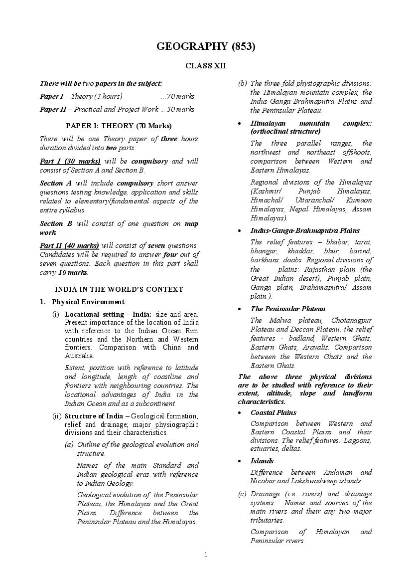
CLASS XII
There will be two papers in the subject: (b) The three-fold physiographic divisions:
the Himalayan mountain complex, the
Paper I – Theory (3 hours) ...70 marks
Indus-Ganga-Brahmaputra Plains and
Paper II – Practical and Project Work …30 marks the Peninsular Plateau.
PAPER I: THEORY (70 Marks) • Himalayan mountain complex:
(orthoclinal structure)
There will be one Theory paper of three hours
The three parallel ranges, the
duration divided into two parts:
northwest and northeast offshoots,
Part I (30 marks) will be compulsory and will comparison between Western and
consist of Section A and Section B. Eastern Himalayas.
Section A will include compulsory short answer Regional divisions of the Himalayas
questions testing knowledge, application and skills (Kashmir/ Punjab Himalayas,
related to elementary/fundamental aspects of the Himachal/ Uttaranchal/ Kumaon
entire syllabus. Himalayas, Nepal Himalayas, Assam
Himalayas).
Section B will consist of one question on map
work. • Indus-Ganga-Brahmaputra Plains
Part II (40 marks) will consist of seven questions. The relief features – bhabar, tarai,
Candidates will be required to answer four out of bhangar, khaddar, bhur, barind,
seven questions. Each question in this part shall barkhans, doabs. Regional divisions of
carry 10 marks. the plains: Rajasthan plain (the
Great Indian desert), Punjab plain,
INDIA IN THE WORLD’S CONTEXT Ganga plain, Brahamaputra/ Assam
plain.).
1. Physical Environment
• The Peninsular Plateau
(i) Locational setting - India: size and area.
Present importance of the location of India The Malwa plateau, Chotanagpur
with reference to the Indian Ocean Rim Plateau and Deccan Plateau: the relief
countries and the Northern and Western features - badland, Western Ghats,
frontiers. Comparison with China and Eastern Ghats, Aravalis. Comparison
Australia. between the Western Ghats and the
Extent, position with reference to latitude Eastern Ghats.
and longitude, length of coastline and The above three physical divisions
frontiers with neighbouring countries. The are to be studied with reference to their
locational advantages of India in the extent, altitude, slope and landform
Indian Ocean and as a subcontinent. characteristics.
(ii) Structure of India – Geological formation, • Coastal Plains
relief and drainage; major physiographic Comparison between Western and
divisions and their characteristics. Eastern Coastal Plains and their
divisions. The relief features: Lagoons,
(a) Outline of the geological evolution and
estuaries, deltas.
structure.
• Islands
Names of the main Standard and
Indian geological eras with reference Difference between Andaman and
to Indian Geology. Nicobar and Lakshwadweep islands.
Geological evolution of: the Peninsular (c) Drainage (i.e. rivers) and drainage
Plateau, the Himalayas and the Great systems: Names and sources of the
Plains. Difference between the main rivers and their any two major
Peninsular Plateau and the Himalayas. tributaries.
Comparison of Himalayan and
Peninsular rivers.
1
Page 2
climate: Temperature - factors affecting
(i) Population of India compared to six
temperature. Atmospheric pressure
countries - China, Australia, USA, Canada,
conditions during the year; origin and
Russia and Brazil.
mechanism of the monsoon, Jet streams,
Southern Oscillations; wind and rainfall Population of India as compared to the
distribution during the year; characteristics other six countries with reference to
of the four main seasons - hot and dry, hot percentage of world population and
and wet, cool and dry, cool and wet with India’s position in the world.
reference to temperature distribution in (ii) National and State level patterns of
north and south India, pressure, wind population distribution.
conditions – distribution of resultant
Definition of census. Index of concentration
rainfall; variability of rainfall, incidence of
(highest and lowest index of concentration
droughts and floods. Temperature and as per the latest census), density of
rainfall graphs of Mumbai, Delhi, Kolkata, population – arithmetic and physiological.
Chennai, Jaisalmer and Leh,
Spatial distribution of population in India
Role of various factors affecting Indian and explanation of the factors influencing it
climate – latitudinal extent, distance from – landforms, climate, accessibility and
the sea, northern mountain ranges, level of development that result in this
physiography, monsoon winds, upper air pattern. Comparison of the density at the
circulation, western disturbances and State level and factors influencing it.
tropical cyclones, southern oscillation, El
(iii) Pattern of population growth in the last
Nino; understanding of the concept and
three decades; implications for
mechanism of monsoon; Indian Monsoonal
development.
Regime – onset, rain bearing system, break
in the monsoon, retreat of the monsoon; Meaning of terminologies such as
population, birth rate, death rate,
Seasons of India – with reference to
population growth rate, natural growth
temperature, pressure distribution, wind
rate and absolute growth of population,
systems and local winds (loo, kalbaisaki/
migratory growth, positive and negative
Norwesters, Mango showers; explanation
growth.
of the variability of rainfall in different
areas over different seasons. Population growth of India at national
level – trends of 1921, 1951 and 1981 to
Droughts and Floods – meaning, causes,
the latest Census, absolute growth rate of
affected areas and mitigation programmes.
population. Demographic characteristics of
Temperature and rainfall graphs of
India at the National level- birth rate,
Mumbai, Delhi, Kolkata, Chennai, Leh and
death rate, and natural growth rate from
Jaisalmer.
1991 to the latest Census.
(iv) Natural vegetation: Forest – importance,
Drawing general conclusions about the:
use, misuse and potential both for
exploitation and conservation. Present Impact of rapid growth rate on economic
forest policy. development, on environment; need for
Distinction between vegetation and forest, planned development (to maintain the
virgin vegetation; factors affecting ecological balance).
vegetation. (iv) Migration trends over the last 25 years.
Importance of forest to man; Impact of Explanation of the important terms –
human activity on vegetation. Forest migration, commutation, out migration, in
Conservation – need, Social Forestry (Agro migration, step-wise migration and
forestry, community forestry, commercial
farm forestry, non-commercial farm migrant, push and pull factors.
forestry, urban forestry); Forest Streams of migration: (rural-rural, rural-
Conservation Movement: Van Mahotsav, urban, urban-urban and urban-rural).
Chipko Movement.
Causes for migration - natural, economic,
political and social.
Comparing the consequences of each type
of migration on cities and rural areas.
2
Page 3
trends and patterns of: 1. Rural urban types of irrigation is mainly prevalent.
population 2. Age and sex composition Modern methods: tube wells, multi-purpose
3. Literacy levels 4. Working and non- projects, sprinkler irrigation, Perennial
working population; implications for canals - Advantages and disadvantages.
development. Names of two canals each in Uttar
Study of the causes and trends of rural Pradesh, Punjab, Haryana, Andhra
urban composition, age and sex ratio, Pradesh, Tamil Nadu and Maharashtra.
literacy level, working and non-working Use and misuse of water for irrigation;
population at the National level (highest study of alternative methods of irrigation.
and lowest figures for each of the above) in Overwatering - reasons and regions
the latest census. Implications for affected by it; dangers of overwatering;
development.
Conservation of water resources including
(vi) Settlements their management; rain water harvesting.
Distinction between Rural and Urban (iv) Agriculture: Types, development and
settlements; Rural and Urban Population. problems.
Definition of an Urban area according to (a) Wet and dry farming, crop rotation and
the latest census; Urban agglomeration, crop combination, intensity of
conurbation, urban sprawl, ribbon cropping, problems of Indian
settlement, infill, metropolis, megalopolis. agriculture; use of technology in
agriculture. Modern inputs, change
3. Resources of India and their Utilisation over from subsistence to commercial
(i) Need for environmental management vis-à- agriculture, need for Green Revolution.
vis development. Diversifying Indian agriculture –
Understanding that from the development importance of animal husbandry.
point of view, environment may mistakenly Wet and dry agriculture: Crop rotation
be seen as a ‘resource’ to be exploited, and crop combination. Intensity of
whereas, environment needs to be viewed cropping – concept and crops
as a ‘capital’ that needs to be managed associated; problems of Indian
carefully. agriculture; Use of new technology –
Green revolution: Need, impact and
(ii) Land resources: Land use pattern in India – problems, second green revolution -
quality of cultivable land, size of land strategies for second green revolution.
holdings. Diversification of Indian agriculture –
Defining the term land resource; its Animal Husbandry: meaning and its
importance and problems. Land use pattern importance in Indian Agriculture.
– net sown area, area sown more than
once, forests, land not available for (b) Study of crops:
cultivation, permanent pastures and other (i) Conditions of growth (soil,
grazing lands, land under miscellaneous temperature, rainfall requirements, crop
tree crops, culturable (cultivable) waste, seasons, secondary crops cultivated
fallow land, quality and size of cultivable with them). (ii) World production and
land holdings. Methods to reduce India’s position. (iii) Major producing
fragmentation of land holdings. States in India and their rank as
producers of the following crops:
(iii) Water resources and types of irrigation.
Food grains - Rice (Japan) and Wheat
Water Resources: Their demand and (China)
utilization. Types of water resources:
surface and ground water. Commercial and Industrial crops –
Tea (Sri Lanka) and Cotton (Pakistan)
Meaning, importance and need for
irrigation in India. Conditions of growth: For each crop,
the type of soil, temperature range,
Sources of irrigation: rainfall range, the crop seasons are to
Traditional Methods: wells, tanks, tube be done.
wells - Advantages and disadvantages;
3
Page 4
crops, in the countries specified, and potential and limitations in India.
reasons for growth are to be studied. Environmental concerns with regard to
Name of the leading producer their use (global warming, thermal
(country) in the world for each of the pollution in waters, fly ash,
above crops (Food grains, commercial atmospheric pollution, etc.).
and industrial crops) and India’s (c) Non-conventional energy sources - types
position in the world. of non-conventional sources (bio-mass,
Importance of Market Gardening and solar, wind, ocean, hydel, geothermal,
Orchard Farming – reasons and trends in nuclear), potential (Indian context) and
development in recent years. limitations of each source; their
environmental consequences; need to
Self-explanatory
promote non-conventional energy sources.
(v) Fishing in India, Japan and Bangladesh. Advantages and limitations of each non-
Methods, types of fish caught, fishing conventional energy source.
grounds; factors affecting the importance Uses of these energy sources and
and development, fishing ports and distribution.
markets, need and methods of fish
Understanding the need to promote non-
conservation.
conventional energy sources.
Understanding of marine and inland
(The study should include uses and the
fisheries; deep sea and inshore fishing;
distribution of the above energy
pelagic and demersal fishing should be
resources).
done. Problems affecting fishing in India,
Japan and Bangladesh should be also 4. Infrastructural Resources (Development of
taken up. Transport and Communication).
Two ports and two types of fishes of each
(a) Railways, Roadways, Water transport
coastal State in India should be studied.
(inland and coastal), Air transport,
(vi) Sources of Energy Pipelines - these modes of transport are to
(a) Minerals and power resources. be studied with regard to –
Distinguishing between metallic and Location and state wise distribution of air,
road and rail routes; location of waterways
non-metallic minerals; ferrous and
and pipelines; natural and economic factors
non-ferrous minerals. that govern their distribution; density and
Production and distribution (three growth. Patterns in India.
leading States and three leading The present position, areas well and poorly
centres in each State) of Iron ore, served by each mode.
mica, coal, manganese and petroleum;
their uses. Problems – comparative advantage of each
mode of transport, national goals to be
Iron ore, mica, coal: their types. achieved in the development of modes of
The main power resources - Nuclear transport (The Golden quadrilateral - its
thermal, hydel; three main States for north-south and east-west corridor).
generation of nuclear thermal and Ports, their location and advantage; major
hydel power in India. exports and imports of different ports.
(b) Conventional energy sources - fossil Nature and direction of trade from the
ports. International trading patterns and
fuels and firewood, potential (Indian
products in the last five years.
context) and limitations of each
source, methods of harnessing and Distinguishing between harbour and port;
environmental consequences of their natural and artificial harbours. Location of
use. major ports in India and their advantage;
main items of export and import from
Conventional energy sources:
different ports and the patterns in the last
Firewood – for heating and cooking five years.
along with agricultural and animal
waste.
4
Page 5
communication in rural development and Iron and Steel Plant (Bhadravati), Bhilai
its policy. Importance of infrastructure as Iron and Steel Plant (Bhilai), Rourkela
key to the development of an industrial Iron and Steel Plant (Rourkela),
economy. Hindustan Steel Limited Plant
Modern means of communication - (Durgapur), Bokaro Iron and Steel Plant
satellites and remote sensing - Geographic (Bokaro), Salem Iron and Steel
Information Systems (GIS), cellular Plant (Salem), Vishakhapatnam Iron
phones, radio, doordarshan, internet; and Steel Plant (Vishakhapatnam),
difference between mass communication (Integrated and mini steel plants:
and tele communication. Prasar Bharti. meaning, advantages and disadvantages
Infrastructure as key to the development of also to be studied.)
an industrial economy. NOTE: Factors responsible for the
location, development and present
5. Industries status of the Agro and Mineral based
(a) Study of the location and distribution of industries mentioned above, as well as
important industrial centres; a general the distribution centres are to be
comparison of disparities. studied.
Self-explanatory. Difference between key and footloose
industry; industrial clusters and indices
(b) Major and minor industrial regions – to identify industrial clusters; industrial
factors governing their growth. inertia.
Reasons for the spread of industrial areas; Maps and sketches of Industrial regions
Understand how the distribution of heavy and centres (location of agro based and
and consumer industries varies in the mineral based industries) should be the
different regions; Understanding why basis for explaining the pattern of
certain industries are more in a particular industrial development.
region.
Major Industrial regions: Mumbai-Pune, (d) Tourism industry – Major natural and
Hooghly, Bengaluru-Tamil Nadu, Gujarat, cultural tourist areas in India. Their special
Chota Nagpur, Vishakhapatnam-Guntur, features and level of development - impact
Gurgaon-Delhi-Meerut. on environment and local economy. Tourist
flows.
Minor Industrial regions: Ambala-
Amritsar, Saharanpur-Muzaffarnagar, Definition of tourism, growth of tourism,
Northern Malabar. advantages of tourism, important places –
both natural and cultural. Positive and
Factors governing the growth of the above negative impact of tourism, problems of
to be studied. tourism and measures for developing eco-
(c) Location, production and growth of the tourism.
following industries:
(i) Agro based industries – Cotton textile 6. Regional Economic Development
and ready-made garments. (Case studies)
Cotton Textiles: Case studies will be preceded by a brief
Maharashtra (Mumbai and Pune), understanding of the meaning of development,
Gujarat (Ahmedabad and Surat), West multilevel planning and planning regions.
Bengal (Kolkata and Howrah), Tamil These case studies will be undertaken with
Nadu (Madurai and Chennai). reference to the advantages and disadvantages
that have accrued to the people and area -
Ready-made garments: aspects covered will be their geographical
Delhi, Bengaluru, Mumbai, Kolkata location, resource base, developmental history,
(ii) Mineral based industries – Iron and present trends of population, occupations,
steel agriculture and industrial activities, issues of
development.
The following industrial centres are to
be studied.
5
Page 6
mining, silk industry and farming. Movement of Southwest and North east monsoon
2. Electronics industry in Bengaluru– reasons winds from season to season, area of low and high
for its development, extent, national and pressure varying from season to season, direction
international linkages and problems. of westerly and easterly jet streams, average
3. Growth of Haldia port, its industries and annual rainfall distribution in India, Main drought
hinterland. prone and flood prone areas.
Population:
7. Map Work
The States of India (according to the latest Census)
A question on map work will be set to identify any for the following: The Lowest density of
of the following items studied in topics 1-6:
population, highest density of population, highest
MAP LIST: level of urbanization, lowest level of urbanisation,
highest Index of Concentration of population, the
Locational setting of India: highest sex ratio, the lowest sex ratio, the highest
804’N-3706’N, 6807’E- 97025’E (Latitudinal and literacy, the lowest literacy;
longitudinal extent of India); 23.5 0 N (Central
latitude) and 82.5 0 E (Central longitude); Indira Urban cities of Delhi, Mumbai, Chennai, Kolkata,
Col and Cape Comorin (Northern and Southern Bengaluru, Ahmedabad and Lucknow.
point of mainland India). Resources of India:
Mountains: Main region of intense cropping in India; Main
3 parallel ranges of Himalayas, Trans Himalayan State/regions of India for: wells, tanks, tube wells,
range – Karakoram, Pir Panjal, Ladakh, Zaskar. perennial canals.
Aravallis, Vindhyas, Satpura, Western and Eastern
Ghats, Nilgiris, Cardamom hills, Garo, Khasi, Agriculture:
Jaintia hills, Patkoi hills, Naga hills, Mizo hills. Main producing States/regions of India for: Rice,
Peaks: Wheat, Tea and Cotton.
Mount Everest, Godwin Austin, Kanchenjunga, Minerals:
Gurushikhar, Dodabetta, Anaimudi, Mahendragiri, Iron Ore (Keonjhar, Bellary, Raigarh, Singhbhum),
Plains: Coal (Jharia, Bokaro, Raniganj), Petroleum
(Digboi, Mumbai High, Ankleshwar, Bassein),
Indus-Ganga-Brahmapurtra region, Konkan, Manganese (Sundergarh, Nagpur) Mica (Nellore,
Kanara, Malabar, Coromandel, Northern Circars. Bhilwara).
Plateaus: Power resources:
Malwa, Chota Nagpur, Deccan, Meghalaya. Nuclear Power (Kaiga, Kalpakkam, Tarapur,
Peninsula: Rawatbhata, Narora, Kakrapara), Thermal Power
(Bongaigaon, Santaldih, Panipat, Ahmedabad,
Kathiawar, Kachchh.
Chandrapur, Nevyelli, Trombay, Vijaywada);
Lakes: Hydroelectric power stations (Bhakra Nangal,
Chilika, Pulicat. Hirakud, Damodar, Nagarjunasagar,
Tungabhadra, Rihand).
Waterbodies:
Industries:
Arabian Sea, Bay of Bengal, Palk Strait, Gulf of
Kachchh, Gulf of Khambat, Cotton Textiles: Mumbai, Ahmedabad Surat and
Madurai.
Passes:
Iron and Steel: TISCO(Jamshedpur), Bhilai Iron
Karakoram, Shipki La, Nathu La, Bomdi La, and Steel Plant (Bhilai), Vishakhapatnam Iron and
Palghat, Bhorghat, Thalghat. Steel Plant (Vishakhapatnam);
Rivers: Oil refineries: IOCL (Digboi and Haldia).
Indus, Jhelum, Chenab, Ravi, Beas, Sutlej, Ganga, Transport:
Yamuna, Gomti, Ghaghara, Gandak, Kosi,
Trace the route of: National Highway 1, National
Chambal, Betwa, Ken, Son, Damodar, Luni, Highway 2, National Highway 6, National highway
Narmada, Tapi, Mahanadi, Godavari, Krishna, 7, Golden Quadrilateral - 4 sides, North south
Kaveri, Brahmaputra.
6
Page 7
Highest Density of roads. about human occupations and stage of
economic development of the area.
Ports:
Kandla, Mumbai, Marmagao, New Mangalore, (v) Introduction to Geographic Information
Kochi, Tuticorin, Haldia, Chennai, System: Elements of visual interpretation
Vishakhapatnam, Kolkata. of remote sensing maps/ images.
Hinterland: Colour significance in the image and true
colour (false colour composition): texture;
Kolkata, Haldia. size; shape; shadow; association.
Case studies: (Reference material – Wikipedia, Google.
Tracing of the Chattisgarh region, city of earth, IIRS Hyderabad).
Bengaluru and its connectivity (road and rail ways)
(vi) Elementary principles of surveying an area:
with the adjacent megacities & ports and
preparing two plans of school compound
hinterland of Haldia.
and/or a small area using Plane table/ GPS.
SKETCH MAPS
2. Project Work (Assignment):
Candidates should be able to draw, label,
understand and interpret the sketch maps related to Local field surveys on any one of the following
the following topics: will be submitted as Project Report. These
surveys should be organized with a table of
• Locational setting of India; contents, sample taken and statistical methods
• Relief and drainage of India;
used, interview schedule. The report should be
• Climate;
organized systematically, and the conclusions
• Population;
should be clearly stated.
• Industries.
(i) Agricultural land use survey.
Choose a district or topographical map of
PAPER II: PRACTICAL WORK AND an area 1: 250000 and make a sketch map
PROJECT WORK (30 Marks) showing land use; compare the patterns of
Candidates will be required to undertake the these. Alternatively, a local village could
following Practical work and Project work . be chosen and the fields mapped from the
1. Practical Work: cadastral map with information on the
crops grown in different seasons and the
Any one of the following topics to be location of the village, its roads and
undertaken:
landmarks, if any.
(i) Drawing of scales: linear, graphic scales
(ii) Household survey of about 30-60
showing primary and secondary divisions;
representative fractions and statement of households of a village or locality.
scale methods. Family size, age structure, educational
(ii) Drawing of cross-section or profiles of background, occupation, involvement of
important contours, viz. ridge, plateau, men and women in economic activity,
escarpment, valley, conical hill, types of educational service. Draw conclusions to
slope, sea cliffs, waterfalls, spurs, by using reflect the economic development of the
vertical exaggeration and horizontal households.
equivalent.
(iii) Amenity study.
(iii) Understanding and illustrating location
references of SOI maps. Study of hospitals in a city, schools (school
where you studied), post offices, municipal
(iv) Map reading and interpretation of survey of zones within the city (blocks in a village
India maps: Study will be based on study) – reasons for travel (based on the
representative portions of any two importance and demand for the place),
topographical sheets. It will include the travel time, travel distance, mapping the
description of location, extent, relief hinterland of the service.
features, drainage, land use, settlement
7
Page 8
employed person. assessed by the teacher and a Visiting Examiner
appointed locally and approved by the Council.
Visit a manufacturing unit or self-employed
No question paper for practical work and project
person – cycle or car repair shop, small
work will be set by the Council.
fabricating unit, factory if nearby and find out
– source of raw material, supply routes, final Evaluation of Practical Work and Project Work will
product, areas where it is sent, manpower be as follows:
strength and their organization.
Practical file (Sessional Record): 10 marks
(v) Area development of a multipurpose river
Assignment (Project Report): 10 marks
valley project – impact on the region.
Viva voce: 10 marks
Self-explanatory.
8
Document Details
| Board / Org | CISCE |
| Exam | Class 12 |
| Type | Syllabus |
| Pages | 8 |
| Language | english |
| Updated | 22 Jul 2026 |