Karnataka 1st PUC Model Question Paper 2022 for Geography (English Medium)
Finished viewing? Save it for later —
Download Karnataka 1st PUC Model Question Paper 2022 for Geography (English Medium) (PDF · 4 pages)About Karnataka 1st PUC Model Question Paper 2022 for Geography (English Medium)
Karnataka 1st PUC Model Question Paper 2022 for Geography (English Medium) is available here for free download. Published by Karnataka Board for Class 11, this sample paper can be viewed online or downloaded as a PDF (4 pages). Candidates preparing for Class 11 can use Karnataka 1st PUC Model Question Paper 2022 for Geography (English Medium) to understand the exam pattern, the type of questions asked, and the overall difficulty level.
Frequently Asked Questions
How can I download Karnataka 1st PUC Model Question Paper 2022 for Geography (English Medium)?
Open this page and click the Download button to save Karnataka 1st PUC Model Question Paper 2022 for Geography (English Medium) as a PDF. It is completely free on AglaSem Docs.
Is Karnataka 1st PUC Model Question Paper 2022 for Geography (English Medium) free to download?
Yes. Karnataka 1st PUC Model Question Paper 2022 for Geography (English Medium) can be viewed online and downloaded as a PDF free of cost on AglaSem Docs.
How many pages does Karnataka 1st PUC Model Question Paper 2022 for Geography (English Medium) have?
Karnataka 1st PUC Model Question Paper 2022 for Geography (English Medium) contains 4 pages, which you can read online or download together as a single PDF.
Where can I find more Class 11 study material?
You can find more Class 11 question papers, sample papers, syllabus, and answer keys on AglaSem Docs.
Karnataka 1st PUC Model Question Paper 2022 for Geography (English Medium) – Text
Read the full text of this sample paper below — useful to quickly search, copy and reference the content online without downloading the PDF.
📄 View text version (4 pages)
Page 1
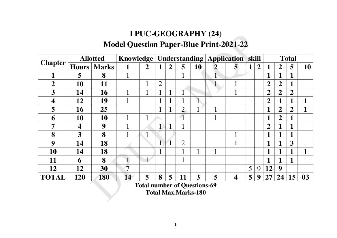
Model Question Paper-Blue Print-2021-22
Allotted Knowledge Understanding Application skill Total
Chapter
Hours Marks 1 2 1 2 5 10 2 5 1 2 1 2 5 10
1 5 8 1 1 1 1 1 1
2 10 11 1 2 1 1 2 2 1
3 14 16 1 1 1 1 1 1 2 2 2
4 12 19 1 1 1 1 1 2 1 1 1
5 16 25 1 1 2 1 1 1 2 2 1
6 10 10 1 1 1 1 1 2 1
7 4 9 1 1 1 1 2 1 1
8 3 8 1 1 1 1 1 1
9 14 18 1 1 2 1 1 1 3
10 14 18 1 1 1 1 1 1 1 1
11 6 8 1 1 1 1 1 1
12 12 30 7 5 9 12 9
TOTAL 120 180 14 5 8 5 11 3 5 4 5 9 27 24 15 03
Total number of Questions-69
Total Max.Marks-180
1
Page 2
Subject - GEOGRAPHY (24)
Time: 3 Hours15 Minutes (Total no. of questions-69) Max. Marks: 100
Instructions:- (i) Answer all the questions.
(ii) Draw maps and diagrams wherever necessary.
(iii) Alternative questions for question No.V (B, C, D)56 to 69
are given for Blind candidates at the end of question paper
as question numbers 56,57 and 58.
I. Answer any TEN of the following questions in a word or sentence each. 10X1=10
1. Who is the father of geography?
2. What is the total geographical area of the earth?
3. On what date does the summer solstice occur?
4. What is continental crust?
5. Which is the most destructive earthquake wave?
6. What is geomorphic process?
7. Name any one agent of physical weathering.
8. Which is the lower layer of atmosphere?
9. Define oceanography.
10. Write the meaning of biosphere.
11. State the meaning of ecological balance.
12. Name the southernmost point of main land of India.
13. Where do Western and Eastern Ghats meets?
14. What type of climate is found in India?
15. What do you mean by natural hazard?
II. Answer any TEN of the following questions in 2-3 sentences each. 10X2=20
16. Mention any two branches of human geography.
17. Name the highest and lowest points of the land.
18. Distinguish between Perihelion and Aphelion.
19. Which scales are used to measure the intensity of earthquakes?
20. What are the metallic minerals?
21. Give any two examples of agents of denudation.
22. Write the any four gases of atmosphere.
23. Mention any two factors that determine the climate of a place.
24. State any four dissolved minerals in the ocean water.
25. Which are the two types of ocean currents?
26. Name the types of environment.
27. State the water bodies that surround India.
28. Mention the two hill stations of Himalayas.
29. State any four measures in conservation of soil.
30. Name the two most important seismic zones of India.
1
Page 3
31. Describe the important branches of geography.
32. Briefly explain the proofs in support of the spherical shape of the earth.
33. Explain the types of volcanoes.
34. What is a rock? Briefly explain the igneous rocks.
35. Explain the chemical weathering with examples.
36. Describe the planetary winds with neat diagram.
37. What is rainfall? Explain the types of rainfall.
38. Describe the topography of the ocean floor with a diagram.
39. What are biomes? Discuss the types of biomes.
40. Analyse the location and size of India.
41. Write the significance of the Northern plains.
42. Explain the west coastal plain of India.
43. Compare the north Indian rivers with south Indian rivers.
44. Write a note on Southwest monsoon season.
45. Briefly explain the distribution of flood prone areas of India.
IV. Answer any ONE of the following questions. 10X1=10
46. Describe the landforms associated to work of river.
47. Explain the major pressure belts of the world with a neat diagram.
48. Describe the types of forests in India.
V. (A) Answer any FIVE of the following questions in a word or sentences each. 5X1=5
49. Define Cartography.
50. What is Scale?
51. Name any two essentials of map.
52. Give any one example for small scale map.
53. Mention any two uses of map.
54. Write the geographical symbol of river.
55. What is economic maps?
(B). Identify the latitudes and longitudes for the given places in the map of Karnataka.
Vv 5X1=5
56. Madikeri.
57. Bengaluru.
58. Haveri.
59. Bellary.
60. Bidar.
2
Page 4
61. Temperature zones.
62. Volcano.
63. Special latitudes.
64. Ox bow lakes.
65. Layers of the Earth’s interior.
66. Tides.
(D). Draw the outline map of India and name the following.
67. Draw the outline map of India. 2
68. Godavari and Kaveri river. 2
69. Mumbai and Bengaluru. 2
(FOR BLIND STUDENTS ONLY)
Answer the following questions 3X5=15
56. Explain the effects of Rotation of the earth.
57. Describe the international boundaries of India.
58. Discuss the types of soils in India.
**********************
3
Document Details
| Board / Org | Karnataka Board |
| Exam | Class 11 |
| Type | Sample Paper |
| Pages | 4 |
| Language | english |
| Updated | 30 Apr 2026 |