CBSE Class 12 Sample Paper 2027 for Geography
Finished viewing? Save it for later —
Download CBSE Class 12 Sample Paper 2027 for Geography (PDF · 12 pages)About CBSE Class 12 Sample Paper 2027 for Geography
CBSE Class 12 Sample Paper 2027 for Geography is available here for free download. Published by CBSE for Class 12, this sample paper can be viewed online or downloaded as a PDF (12 pages). Candidates preparing for Class 12 can use CBSE Class 12 Sample Paper 2027 for Geography to understand the exam pattern, the type of questions asked, and the overall difficulty level.
Frequently Asked Questions
How can I download CBSE Class 12 Sample Paper 2027 for Geography?
Open this page and click the Download button to save CBSE Class 12 Sample Paper 2027 for Geography as a PDF. It is completely free on AglaSem Docs.
Is CBSE Class 12 Sample Paper 2027 for Geography free to download?
Yes. CBSE Class 12 Sample Paper 2027 for Geography can be viewed online and downloaded as a PDF free of cost on AglaSem Docs.
How many pages does CBSE Class 12 Sample Paper 2027 for Geography have?
CBSE Class 12 Sample Paper 2027 for Geography contains 12 pages, which you can read online or download together as a single PDF.
Where can I find more Class 12 study material?
You can find more Class 12 question papers, sample papers, syllabus, and answer keys on AglaSem Docs.
CBSE Class 12 Sample Paper 2027 for Geography – Text
Read the full text of this sample paper below — useful to quickly search, copy and reference the content online without downloading the PDF.
📄 View text version (13 pages)
Page 1
CBSE Class 12 Sample
Paper 2027 for
Geography
EXAM YEAR TYPE SUBJECT
CBSE Class 12 2027 Sample Paper Geography
Notes · Sample Papers · Previous Year Papers · Mock Tests
Page 2
m .co
m .co s e m
se g l a
a
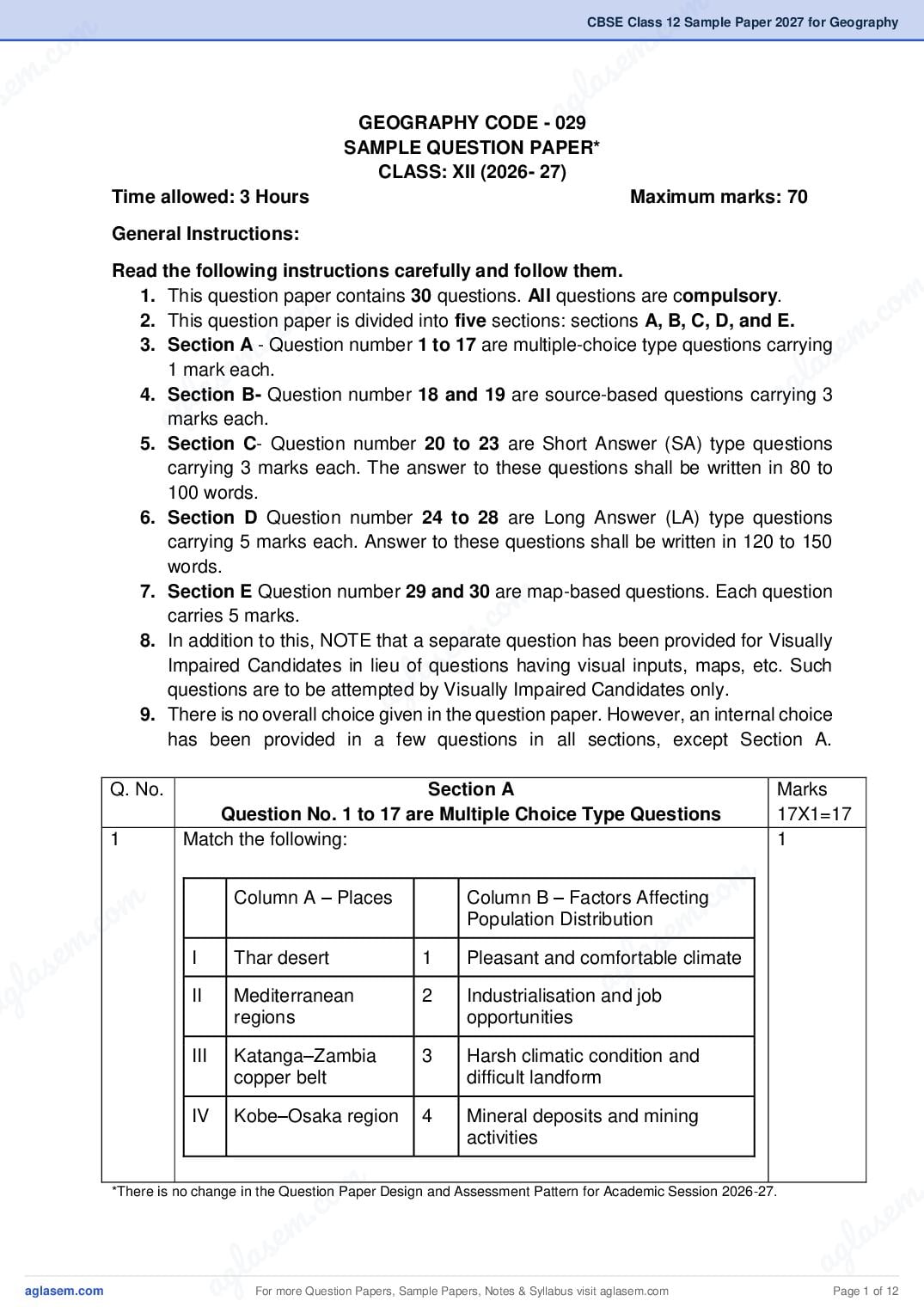
GEOGRAPHY CODE - 029
SAMPLE QUESTION PAPER*
CLASS: XII (2026- 27)
Time allowed: 3 Hours Maximum marks: 70
General Instructions:
Read the following instructions carefully and follow them.
m
.co
1. This question paper contains 30 questions. All questions are compulsory.
m
.co
2. This question paper is divided into five sections: sections A, B, C, D, and E.
e m
e m
3. Section A - Question number 1 to 17 are multiple-choice type questions carrying
l as
s
1 mark each.
l a ag
g
4. Section B- Question number 18 and 19 are source-based questions carrying 3
a
marks each.
5. Section C- Question number 20 to 23 are Short Answer (SA) type questions
carrying 3 marks each. The answer to these questions shall be written in 80 to
100 words.
6. Section D Question number 24 to 28 are Long Answer (LA) type questions
carrying 5 marks each. Answer to these questions shall be written in 120 to 150
words.
m
7. Section E Question number 29 and 30 are map-based questions. Each question
carries 5 marks.
m .co
e
8. In addition to this, NOTE that a separate question has been provided for Visually
s
la
Impaired Candidates in lieu of questions having visual inputs, maps, etc. Such
ag
questions are to be attempted by Visually Impaired Candidates only.
9. There is no overall choice given in the question paper. However, an internal choice
has been provided in a few questions in all sections, except Section A.
Q. No. Section A Marks
Question No. 1 to 17 are Multiple Choice Type Questions 17X1=17
1 Match the following: 1
m
m Column A – Places Column B – Factors Affecting
.co
m .co Population Distribution
s em
s e I Thar desert 1
g la climate
Pleasant and comfortable
g la a job
a II Mediterranean
regions
2 Industrialisation and
opportunities
III Katanga–Zambia 3 Harsh climatic condition and
copper belt difficult landform
IV Kobe–Osaka region 4 Mineral deposits and mining
activities
m .
.co m
s e
s em l a
g la ag
a For more Question Papers, Sample Papers, Notes & Syllabus visit Page 1 of 12
Page 3
A. I-2, II-1, III-4, IV-3
B. I-1, II-2, III-3, IV-4
C. I-3, II-1, III-4, IV-2
D. I-2, II-3, III-1, IV-4
2 The Government of India has introduced the Beti Bachao Beti Padhao 1
programme to address the issue of decline in child sex ratio. Which one
of the following options will lead to a more meaningful life for girls?
A. Providing financial incentives only at the time of marriage.
B. Encouraging families to support girls’ education.
C. Restricting girls from pursuing higher studies.
D. Making girls responsible for household work.
3 A disaster management team wants to set up temporary shelters in 1
Region Y, which has a population of 80,000 and an area of 200 sq km.
To plan resources, they must know how densely populated the region
is. What is the population density of Region Y?
A. 200 persons per sq km
B. 300 persons per sq km
C. 400 persons per sq km
D. 800 persons per sq km
4 In which of the following countries you can expect a higher investment 1
in people providing education and healthcare as priority and good
governance.
Sl No. Country HDI 2022
1. Iceland 0.959
2. Denmark 0.952
3. Tajikistan 0.679
4. El Salvador 0.674
5. Burkina Faso 0.438
6. Niger 0.394
A. Niger and El Salvador
B. Burkina Faso and Tajikistan
C. Tajikistan and Niger
D. Iceland and Denmark
For more Question Papers, Sample Papers, Notes & Syllabus visit Page 2 of 12
Page 4
m .co
m .co s em
se g la
5 a to rural marketing 1
Which of the following statements are correct related
centres? Choose the correct option.
i. Rural marketing centres cater to nearby settlements.
ii. Rural Marketing centres are quasi-urban trading centres of the
most rudimentary type.
iii. They offer manufactured goods as well as many specialized
markets develop, e.g. markets for labour, housing, semi or
m
.co
finished products.
m
.co m
iv. Personal and professional services are not well-developed.
m
These form local collecting and distributing centres.
s e
s e l a
ag
Options:
g l aA. i, ii, iv
a B. i, iii, iv
C. ii, iii, iv
D. i, ii, iii
6 How does industrial nations help to step up the volume of trade in 1
developing nations?
i. By developing industries like mining, oil drilling, heavy
engineering etc in developing countries.
m
.co
ii. By not importing food stuffs and minerals from the developing
m
countries.
s e
la
iii. By creating markets for their finished products in developing
g
countries
a
iv. By not opening the market for developing countries and
increasing the import tariff by 50%.
A. I, III
B. III, IV
C. II, III
D. I, IV
m 1
.co
7 Which of the following is a major concern associated with rapid
m
.co em
growth of international trade in recent times?
e m l s
a promotes
las g
A. It reduces dependence on natural resources and
a
g
sustainable development.
a B. It can lead to exploitation of natural resources, causing
environmental degradation.
C. It decreases commercial rivalry and prevents conflicts between
nations.
D. It ensures equal development among all participating countries.
m .
.co m
s e
s em l a
g la ag
a For more Question Papers, Sample Papers, Notes & Syllabus visit Page 3 of 12
Page 5
would increase faster than the food supply. Which of the following
statements is NOT supported by Malthus’ theory?
A. Food shortage would result in a decline in population.
B. The rate of food supply would be faster than the population
growth.
C. Preventive checks are preferable to control population growth.
D. To ensure sustainability of resources, population growth
needs to be controlled.
9 The table given below shows the crude birth rate and the crude death 1
rate in India. Identify the year that registered the highest natural
growth rate?
Decades Crude Birth rate Crude Death rate
per 1000 per 1000
2001-2011 21.8 7.1
1991-2001 25.4 8.4
1981-1991 29.5 9.8
1971-1981 37.2 15
A. 1991-2001
B. 2001-2011
C. 1971-1981
D. 1981-1991
10 Which of the following schemes is promoted by the Government for 1
organic farming?
A. PM-KISAN
B. Soil Health Card Scheme
C. Paramparagat Krishi Vikas Yojana (PKVY)
D. Krishi Vikas Yojana
For more Question Papers, Sample Papers, Notes & Syllabus visit Page 4 of 12
Page 6
m .co
m .co s e m
se g l a
11 a 1
m
m .co
.co s e m
s em l a
g la ag
a In 2019-20, which category of land use has undergone the highest rate
of increase in comparison to 1950-51?
A. Forest
B. Barren land & unculturable waste land
C. Culturable wasteland
D. Area under non-agricultural use
m
.co
em
The following question is for Visually Impaired Candidates only
In lieu of Question No. 11
s
la cultivation for one or less than one
a g
The land which is left without
agricultural year is known as:
A. Fallow other than Current Fallow
B. Culturable Wasteland
C. Current Fallow
D. Land put to Non-agricultural Uses
12 The map given below shows the major river basins of India. Identify the 1
m
m river basin that covers the states of UP, Bihar and West Bengal.
.co
m .co s e m
s e A. Krishna Basin
g l a
g la B. Pennar Basin
a
a C. Ganga Basin
D. Indus Basin
m .
.co m
s e
s em l a
g la ag
a For more Question Papers, Sample Papers, Notes & Syllabus visit Page 5 of 12
Page 7
In lieu of Question No. 12
Name the largest river basin of India.
A. Krishna Basin
B. Pennar Basin
C. Ganga Basin
D. Indus Basin
13 Assertion(A): The Iron and steel industry in India is majorly 1
concentrated in the north eastern part of the Peninsular Plateau.
Reason(R): Most of the metallic minerals in India occur in the
peninsular plateau region in the old crystalline rocks.
A. Both A and R are correct and R is the correct explanation of A.
B. Both A and R are correct and R is not the correct explanation of
A.
C. A is correct but R is incorrect.
D. R is incorrect but A is correct.
14 There is a declining availability of freshwater and increasing demand 1
from different sectors of the economy in our country. Now the need has
arisen to conserve and effectively manage this precious life giving
resource for sustainable development. Suggest measures that can be
adopted to solve this problem.
For more Question Papers, Sample Papers, Notes & Syllabus visit Page 6 of 12
Page 8
m .co
m .co s e m
se g l a
a
A. Free and easy access of water to industries.
B. Constructing new, large-scale dams for irrigation purposes.
C. Implementing rainwater harvesting, recycling and reusing
wastewater.
D. Extracting more groundwater to increase supply.
15 Given below is a list of National Waterways. Which one of the following 1
is incorrectly matched?
m
.co
Stretch Waterways
m
.co m
1. Allahabad-Haldia NW-1
m s e
a
2. Kottapuram-Kollam NW-5
s e l
a ag
3. Sadiya-Dhubri NW-2
g l
4. Kakinada-Puducherry NW-4
a
A. 1
B. 2
C. 3
D. 4
16 A coastal district is preparing for an approaching cyclone. The disaster 1
management team needs real-time information on cloud movement
m
.co
and storm intensity. Which satellite system will provide the most
reliable support for this purpose?
e m
l s
a Satellite
A. IRS – Indian Remote Sensing
a g
B. INSAT – Indian National Satellite System
C. GSAT – Communication satellite for TV channels
D. PSLV – Launch vehicle for satellites
17 Mr. Netra, a 35-year-old unemployed person from a small village in 1
Nepal, has decided to emigrate to a nearby city in the NCR region of
India. He has three brothers who work on their family-owned small field,
which gives very low returns for the family to survive. Formulate the
likely reasons for his emigration.
m
m .co
m .co I. High paid farming jobs are available in the rural area.
s e m
s e
II. Better employment opportunities in the city.
g l a
la a
III. Sufficient income from agriculture in his village
ag IV.
V.
Better standard of living in rural areas.
More opportunities for training and personal development in the
city.
A. I, III, IV
B. II, V,
C. III, IV
D. I,V
m .
.co m
s e
s em l a
g la ag
a For more Question Papers, Sample Papers, Notes & Syllabus visit Page 7 of 12
Page 9
Question Nos. 18 and 19 are Source Based Questions.
18 Study the map given below carefully and answer the following 3
questions.
1
18.1 Identify the canal shown in the map.
½+ ½
18.2 Which two water bodies are connected by this Canal?
1
18.3 State one major significance of this Canal in international trade.
The following question is for Visually Impaired Candidates only in
lieu of Question No. 18.
18.1Which two water bodies are connected by the Panama Canal?
1
18.2 Between which two cities was the Panama Canal constructed?
½+ ½
18.3 Mention one point explaining how this canal benefits Latin
1
America.
19 Read the passage given below carefully and answer the following
questions.
The uneven spatial distribution of population in India suggests a close
relationship between population and physical, socioeconomic and
historical factors. As far as the physical factors are concerned, it is clear
that climate along with terrain and availability of water largely
determines the pattern of the population distribution. Consequently, we
observe that the North Indian Plains, deltas and Coastal Plains have
higher proportion of population than the interior districts of southern
and central Indian States, Himalayas, some of the north eastern and
the western states. However, development of irrigation (Rajasthan),
availability of mineral and energy resources (Jharkhand) and
For more Question Papers, Sample Papers, Notes & Syllabus visit Page 8 of 12
Page 10
m .co
m .co s em
se g la
development of transport network (PeninsularaStates) have resulted in
moderate to high concentration of population in areas which were
previously very thinly populated.
I. Define the term population distribution. 1
II. Name one physical factor and one economic factor that ½+ ½
influence population distribution.
m
.co
III. Name one densely populated and one sparsely populated area ½+ ½
m
.co m
of India.
s e
em a
Section C (4x3=12)
as
Questions number 20 to 23 are Short Answer Type Questions
g l
l a
20
agExplain the concept of human development as introduced by Dr 3
Mahbub-ul-Haq.
21 “The evolution of Indian towns is a reflection of the changing socio- 3
political and economic priorities of different historical eras.” Analyse the
evolution of modern towns in India.
22 What is Neo-Determinism as introduced by Griffith Taylor? Explain how 1+2=3
it provides a middle path between Environmental Determinism and
Possibilism?
o m
c
. work to a country for tasks 1+2=3
23(A)
m
A multinational company wants to outsource
e and research, such as R&D, legal
s
la type of outsourcing—BPO or KPO—
that require highly skilled knowledge
services, and analysis. Which
should the company choose,
g
a and why?
OR 1+2=3
23(B) What do you understand by the term “Digital Divide?” Explain with one
example of how it exists between countries or within a country.
Section D
Questions number 24 to 28 are Long Answer Type Questions (5X5=25)
24(A) Classify industries based on raw materials and illustrate each category 5
m
om
with appropriate examples.
.co
m
c. 24(B) OR
s em
s e la
Explain any five factors influencing the location of industries with 5
g
g la suitable examples.
a
a 25(A) Why are seaports known as ‘the gateway of international trade’? Write 2+3=5
a brief note on the importance of Kandla port.
OR
25(B) Describe the nature of the changes in the composition of export and 5
import trade of India.
m .
.co m
s e
s em l a
g la ag
a For more Question Papers, Sample Papers, Notes & Syllabus visit Page 9 of 12
Page 11
needs of mankind. Explain the measures that can help in changing
urban waste into resources.
OR
26(B) How has noise pollution become hazardous in many big cities of India? 5
Explain with examples.
27 Distinguish between intensive subsistence farming and extensive 2½+2½=
commercial grain farming, mentioning any five points. 5
28(A) Examine the role of the Indira Gandhi Canal in bringing about changes 5
in the ecology, economy, and society of the Thar Desert region.
OR
28(B) Suggest suitable measures to promote sustainable development and 5
improve the quality of life in the Bharmour Tribal Region of Chamba,
with reference to its physiographic divisions and river systems.
Section E (2X5=10)
Question numbers 29 & 30 are Map based questions.
29 On the given political map of the World, seven geographical features 5
have been marked as A, B, C, D, E, F and G. Identify any five with the
help of the following information and write their correct names.
A -An Area of nomadic herding
B-A major seaport of Canada
C- A major seaport of Asia
D- An airport in Asia
E- An airport in Australia
F- A man made Canal
G- A waterway of North America
For more Question Papers, Sample Papers, Notes & Syllabus visit Page 10 of 12
Page 12
m .co
m .co s e m
se g l a
a
m
m .co
m .co s e m
s e l a
g l a ag
a
m
.co
s em
g lafor Visually Impaired Candidates only
a
The following questions are
in lieu of Question No.29. Answer five questions out of the
following:
29 A. Name one area of nomadic herding of Asia.
29 B. Name a major seaport of Canada.
29 C. Name a major seaport of India.
29 D. Name a major airport in South Africa.
m
.co
29 E. Name an airport in Australia.
m
.co m
29 F. Name the manmade Canal joining the Mediterranean Sea and
m s e
a
the Red Sea.
s e g l
la
29G. Name one major waterway of North America.
g 30 Locate and label any five of the following geographical features on the 5 a
a Political Outline map of India with appropriate symbols:
A. The State with the lowest population density
B. An important seaport in Odisha
C. An important coal mine in Tamil Nadu
D. Bailadila -iron ore mines
E. An oil refinery in Gujarat
m .
.co m
s e
s em l a
g la ag
a For more Question Papers, Sample Papers, Notes & Syllabus visit Page 11 of 12
Page 13
G. An international airport in Kerala
The following questions are for Visually Impaired Candidates only
in lieu of Question No.30. Answer five questions out of the
following:
30A. Which Indian state has the lowest population density?
30B.Name one major seaport located in Odisha.
30C. Name an important coal mine located in Tamil Nadu.
30D. In which state is the famous iron ore mine - Bailadila located?
30E. Name an oil refinery situated in Gujarat.
30F. Which Indian state is the leading producer of sugarcane?
30G. Name one international airport located in Kerala.
For more Question Papers, Sample Papers, Notes & Syllabus visit Page 12 of 12
Document Details
| Board / Org | CBSE |
| Exam | Class 12 |
| Type | Sample Paper |
| Pages | 12 |
| Updated | 29 Oct 2026 |