HP Board Class 11 Model Question Paper 2022 Geography Term 2
Finished viewing? Save it for later —
Download HP Board Class 11 Model Question Paper 2022 Geography Term 2 (PDF · 5 pages)About HP Board Class 11 Model Question Paper 2022 Geography Term 2
HP Board Class 11 Model Question Paper 2022 Geography Term 2 is available here for free download. Published by Himachal Pradesh Board for Class 11, this sample paper can be viewed online or downloaded as a PDF (5 pages). Candidates preparing for Class 11 can use HP Board Class 11 Model Question Paper 2022 Geography Term 2 to understand the exam pattern, the type of questions asked, and the overall difficulty level.
Frequently Asked Questions
How can I download HP Board Class 11 Model Question Paper 2022 Geography Term 2?
Open this page and click the Download button to save HP Board Class 11 Model Question Paper 2022 Geography Term 2 as a PDF. It is completely free on AglaSem Docs.
Is HP Board Class 11 Model Question Paper 2022 Geography Term 2 free to download?
Yes. HP Board Class 11 Model Question Paper 2022 Geography Term 2 can be viewed online and downloaded as a PDF free of cost on AglaSem Docs.
How many pages does HP Board Class 11 Model Question Paper 2022 Geography Term 2 have?
HP Board Class 11 Model Question Paper 2022 Geography Term 2 contains 5 pages, which you can read online or download together as a single PDF.
Where can I find more Class 11 study material?
You can find more Class 11 question papers, sample papers, syllabus, and answer keys on AglaSem Docs.
HP Board Class 11 Model Question Paper 2022 Geography Term 2 – Text
Read the full text of this sample paper below — useful to quickly search, copy and reference the content online without downloading the PDF.
📄 View text version (5 pages)
Page 1
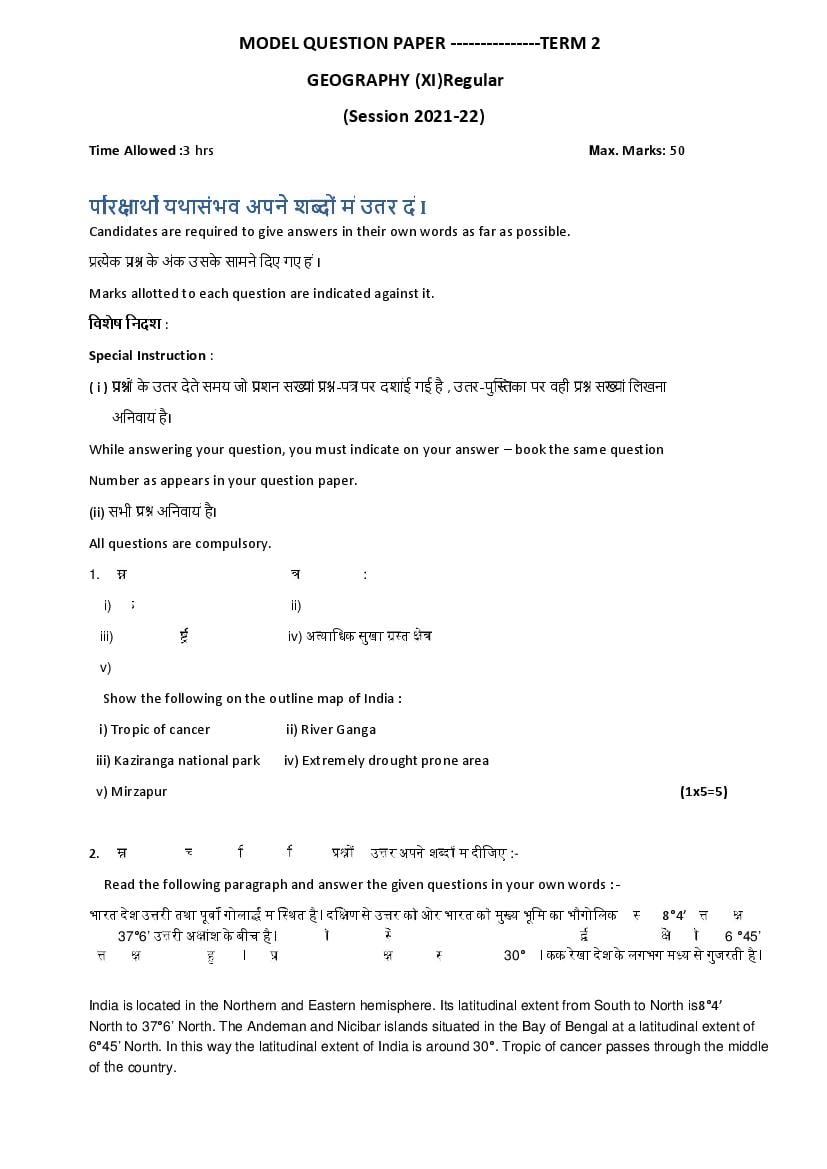
GEOGRAPHY (XI)Regular
(Session 2021-22)
Time Allowed :3 hrs Max. Marks: 50
प र ाथ यथासंभव अपने श ों म उतर द I
Candidates are required to give answers in their own words as far as possible.
ेक के अंक उसके सामने िदए गए ह I
Marks allotted to each question are indicated against it.
िवशेष िनदश :
Special Instruction :
(i) ों के उतर दे ते समय जो शन स ां -प पर दशाई गई है , उतर-पु का पर वही स ां िलखना
अिनवाय हैI
While answering your question, you must indicate on your answer – book the same question
Number as appears in your question paper.
(ii) सभी अिनवाय है I
All questions are compulsory.
1. िन िलिखत को भारत के रे खा मानिच पर दशाइए :
i) कक रे खा ii) गंगा नदी
iii) काजीरं गा रा ीय उदयान iv) अ यािधक सुखा त े
v) िमजापुर
Show the following on the outline map of India :
i) Tropic of cancer ii) River Ganga
iii) Kaziranga national park iv) Extremely drought prone area
v) Mirzapur (1x5=5)
2. िन िलिखत अनु छेद को प ढ़ए तथा दए गए के उ र अपने श द म दीिजए :-
Read the following paragraph and answer the given questions in your own words :-
भारत देश उ री तथा पूव गोला म ि थत है l दि ण से उ र क ओर भारत क मु य भूिम का भौगोिलक िव तार 8°4’ उ री अ ांश से
लेकर 37°6’ उ री अ ांश के बीच है l बंगाल क खाड़ी म ि थत भारत का अंडमान तथा िनकोबार ीप समूह तो दि ण क ओर 6 °45’
उ री अ ांश तक फै ला आ है l इस कार भारत देश का अ ांशीय िव तार लगभग 30° है l कक रे खा देश के लगभग म य से गुजरती है l
India is located in the Northern and Eastern hemisphere. Its latitudinal extent from South to North is8°4’
North to 37°6’ North. The Andeman and Nicibar islands situated in the Bay of Bengal at a latitudinal extent of
6°45’ North. In this way the latitudinal extent of India is around 30°. Tropic of cancer passes through the middle
of the country.
Page 2
In which hemisphere, is India located?
2) भारत कस अ ांशीय िव तार पर ि थत है ?
On which latitudinal extent is India located?
3) बंगाल क खाड़ी म कौन सा ीप समूह ि थत है ?
Which island group is situated in Bay of Bengal?
4) भारत के म य म से कौन सी रे खा गुजरती है ?
Which line passes through the middle of India? (1x4=4)
3. ब िवक ीय :-
िन िल खत ेक के िलए चार वैक क उ र िदए गए ह I सही उ र िलख I
Multiple Choice questions :-
Four multiple choice answers are given for the following questions. Write the correct answer.
i) िन िलिखत म से कौन से देश क भारत के साथ अंतरा ीय सीमा सबसे ल बी है ?
क ) बां लादेश ख ) यनमार
ग ) पा क तान घ ) चीन
Which one o the following country shares the longest land frontier with India?
a) Bangladesh b) Myanmar
c) Pakistan d) China
ii) पृ वी का वह भाग जहाँ सभी कार का जीवन पाया जाता है :-
क ) थलमंडल ख ) जैवमंडल
ग ) वायुमंडल घ ) जलमंडल
The part of earth where all life forms are found :-
a) Lithosphere b) Biosphere
c) Atmosphere d) Hydrosphere
iii ) जैव िविवधता का संर ण िन म से कसके िलए मह वपूण है ?
क ) ज तु ख ) पौधे
ग ) पौधे और ज तु घ ) सभी जीवधारी l
Conservation of biodiversity is important for which of the following ?
a) Animals b) Plants
c) Plants and animals d) All living beings
iv ) िन िलिखत म से कौन सी नदी को ‘बंगाल का शोक’ माना जाता था ?
क ) गंडक ख ) सोन
ग ) कोसी घ ) दामोदर
Page 3
a) The Gandak b) The son
c) The kosi d) The Damodar
v) डे टा देश म कै से वन पाए जाते ह ?
क ) आ पतझड़ वाले वन ख ) शु क पतझड़ वाले वन
ग ) सदाबहार वन घ ) मै ोव वन
Which type of forests are found in Deltic Region?
a) Wet deciduous forests b) Dry deciduous forests
c) Evergreen forests d) Mangrove forests
vi) मजूली नदीय ीप कौन –सी नदी पर ि थत है ?
क ) गंगा ख) गोदावरी
ग ) हमपु घ ) िस धु
On which river is Majuli river island located?
a) Ganga b) Godavari
c) Brahmputra d) Indus
vii) बफानी तूफान कस कार क ाकृ ितक आपदा है ?
क ) वायुमंडलीय ख ) थलीय
ग ) जलीय घ ) जैिवक
What type of natural disaster is a ‘Blizzards’?
a) Atmospheric b) Terrestrial
c) Aquatic d) Biological
viii) भारत क सं पूण भूिम के कतने ितशत भाग पर वन पाए जाते ह ?
क ) 33% ख ) 25%
ग ) 23.3% घ ) 40%
Forests are found on what percentage of the total land area of India?
a) 33% b) 25%
c) 23.3% d) 40%
ix) िन िलिखत न दय म से कौन सी नदी ंश घाटी म बहती है ?
क ) सोन ख ) नमदा
ग ) यमुना घ ) लूनी
Which of the following rivers flows in the rift valley?
a) The Son b) The Narmada
c) The Yamuna d) The Luni
Page 4
क ) मैकमोहन रे खा ख ) रे डि लफ रे खा
ग) डू रंड रे खा घ ) 49 मील
Which is the boundary line between India and China?
a) Macmohan line b) Redciffe line
c) Durand line d) 49 mile
xi) उ णक टबंधीय घास के मैदान िन म से कस नाम से जाने जाते ह :-
क ) ेयरी ख ) टैपी
ग ) सवाना घ ) इनम से कोई नह
Tropical grasslands are known by which of the following names?
a) Prairie b) Steppe
c) Savanna d) None of these (1x11=11)
4. जैव िविवधता या है ? मानव जीवन म इसका या मह व है l (4 )
What is Biodiversity? What is its importance in human life.
5. वन से हम या लाभ ह ? िव तारपूवक वणन क िजए l
What are the benefits of forests to us? Describe in detail. (4)
6. भारत क भौगोिलक ि थित एवं िव तार का वणन करते ए इसक ि थित क उपयोिगता का वणन क िजए l
Describing the geographical location and extent of India, describe the usefulness of its location.
अथवा (or )
भारत के पड़ोसी देश का िव तृत वणन क िजए l
Describe in detail the neighbouring countries of India. (4)
7. िहमालय तथा ाय ीपीय पठार क न दय म अ तर बताओ l
Differentiate between the rivers of Himalayan and Peninsular plateau.
अथवा (or)
भारत म न दय का या मह व है ? वणन कर l
Describe the importance of rivers in India . (4)
8. बाढ़ के िलए उ रदायी पांच मानवीय कारण बताओ l
Give five human reasons responsible for flood. (2)
9. ‘बो रयल’ श द से आप या समझते ह ?
What do you understand by the word ‘Boreal’? (2)
10. भू खलन के या भाव होते ह ?
What are the effects of Landslides? (2)
Page 5
What are deltas called? Write the names of four deltas formed in India. (2)
12. वन के हास् के तीन कारण िलिखए l
Write three reasons for the decline of forests. (2)
13. ाकृ ितक आपदा कसे कहते ह ?
What is natural hazard ? (2)
14. अंत: थली अपवाह कसे कहते ह ? इसका एक उदहारण दीिजएl
What is Inland drainage? Give an example of this. (2)
Document Details
| Board / Org | Himachal Pradesh Board |
| Exam | Class 11 |
| Type | Sample Paper |
| Pages | 5 |
| Updated | 30 Apr 2026 |