Edudel Syllabus 2025 Class 11 Geography
Finished viewing? Save it for later —
Download Edudel Syllabus 2025 Class 11 Geography (PDF · 14 pages)About Edudel Syllabus 2025 Class 11 Geography
Edudel Syllabus 2025 Class 11 Geography is available here for free download. Published by Delhi Board for Class 11, this syllabus can be viewed online or downloaded as a PDF (14 pages). Candidates preparing for Class 11 can use Edudel Syllabus 2025 Class 11 Geography to understand the exam pattern, the type of questions asked, and the overall difficulty level.
Frequently Asked Questions
How can I download Edudel Syllabus 2025 Class 11 Geography?
Open this page and click the Download button to save Edudel Syllabus 2025 Class 11 Geography as a PDF. It is completely free on AglaSem Docs.
Is Edudel Syllabus 2025 Class 11 Geography free to download?
Yes. Edudel Syllabus 2025 Class 11 Geography can be viewed online and downloaded as a PDF free of cost on AglaSem Docs.
How many pages does Edudel Syllabus 2025 Class 11 Geography have?
Edudel Syllabus 2025 Class 11 Geography contains 14 pages, which you can read online or download together as a single PDF.
Where can I find more Class 11 study material?
You can find more Class 11 question papers, sample papers, syllabus, and answer keys on AglaSem Docs.
Edudel Syllabus 2025 Class 11 Geography – Text
Read the full text of this syllabus below — useful to quickly search, copy and reference the content online without downloading the PDF.
📄 View text version (14 pages)
Page 1
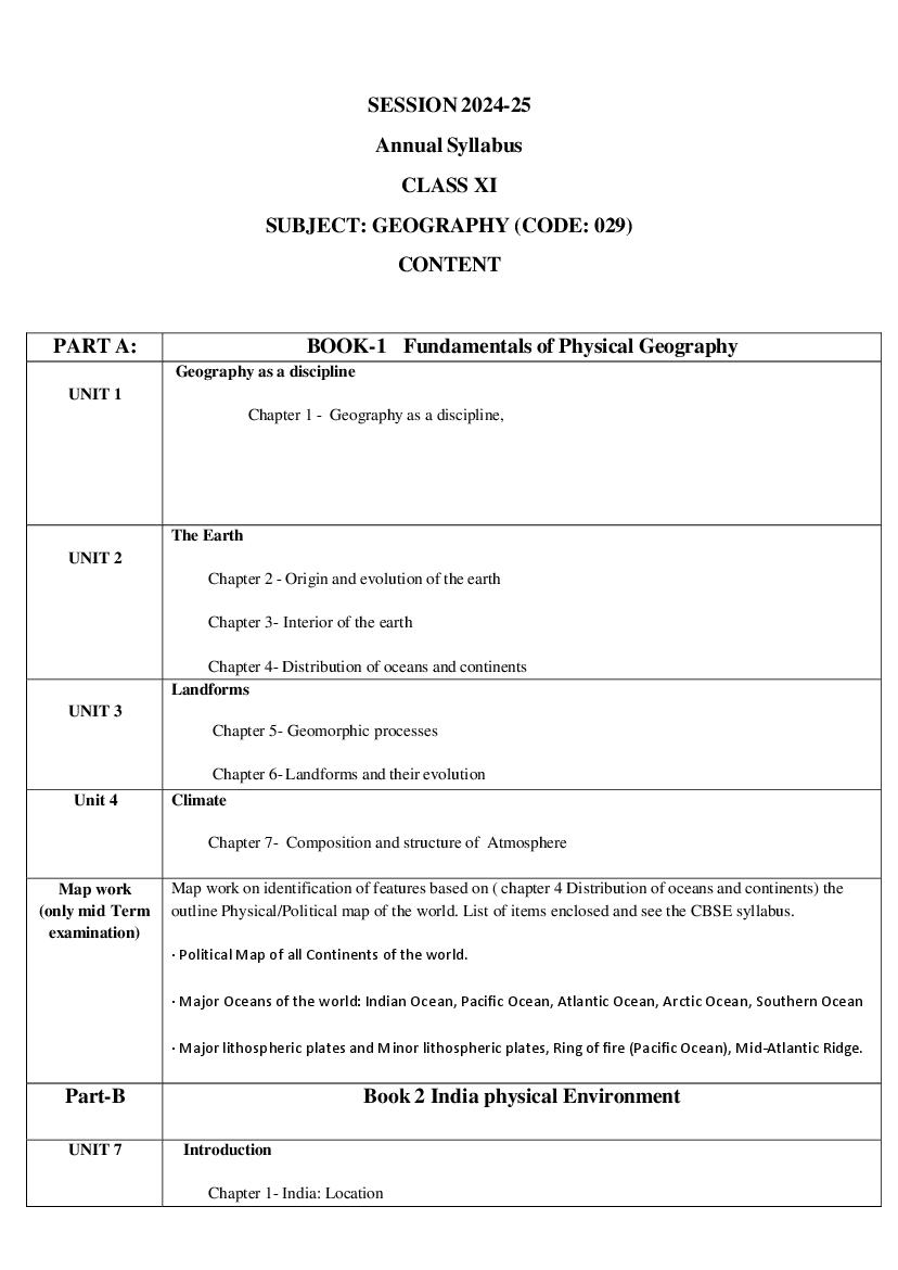
Annual Syllabus
CLASS XI
SUBJECT: GEOGRAPHY (CODE: 029)
CONTENT
PART A: BOOK-1 Fundamentals of Physical Geography
Geography as a discipline
UNIT 1
Chapter 1 - Geography as a discipline,
The Earth
UNIT 2
Chapter 2 - Origin and evolution of the earth
Chapter 3- Interior of the earth
Chapter 4- Distribution of oceans and continents
Landforms
UNIT 3
Chapter 5- Geomorphic processes
Chapter 6- Landforms and their evolution
Unit 4 Climate
Chapter 7- Composition and structure of Atmosphere
Map work Map work on identification of features based on ( chapter 4 Distribution of oceans and continents) the
(only mid Term outline Physical/Political map of the world. List of items enclosed and see the CBSE syllabus.
examination)
∙ Political Map of all Continents of the world.
∙ Major Oceans of the world: Indian Ocean, Pacific Ocean, Atlantic Ocean, Arctic Ocean, Southern Ocean
∙ Major lithospheric plates and Minor lithospheric plates, Ring of fire (Pacific Ocean), Mid-Atlantic Ridge.
Part-B Book 2 India physical Environment
UNIT 7 Introduction
Chapter 1- India: Location
Page 2
Chapter 2- Structure and Physiography
Chapter 3- Drainage systems
Map work Map Work of features based on above units for locating and labelling on the outline Political/Physical
(only mid Term map of India. List of items enclosed and see the syllabus issued by CBSE 2024-25
examination)
Chapter 1 -India- Location
∙ Latitudinal extent of India
∙ Longitudinal extent of India
∙ Standard Meridian of India
∙ Important latitude passing through India (Tropic of Cancer)
∙ Southern Most Point of main land of India (Kanya kumari )
Chapter 2- Structure and Physiography
● Mountains: Karakoram Range, Garo- Khasi- Jaintia hills, Aravalli Range, Vindhyan Range,
Satpura Range, Western ghats & Eastern ghat
∙ Peaks: K2, Kanchenjunga, Nandadevi, Nanga Parvat, Namcha Barwa and Anaimudi
∙ Passes: Shipkila, Nathula, Palghat, Bhor ghat and Thal ghat
∙ Plateaus: Malwa, Chhotnagpur, Meghalaya and Deccan Plateau.
∙ Coastal Plains: Saurashtra, Konkan, North and South Kannad, Malabar, Coromandel and
Northern Circars
∙ Islands: Andaman & Nicobar Islands and Lakshadweep Islands
Chapter-3 Drainage System
● Rivers: Brahmaputra, Indus, Satluj, Ganga, Yamuna, Chambal, Damodar Mahanadi, Krishna,
Kaveri, Godavari, Narmada, Tapti and Luni
∙ Lakes: (Identification)Wular, Sambhar, Chilika, Kolleru, Pulicat & Vembanad
∙ Straits, Bays , Gulfs: Palk Strait, Rann of Kachch, Gulf of Kachch, Gulf of Mannar & Gulf of
Khambat
Part- c Practical work in geography part-1
Chapter 1-Introduction to Maps
Chapter 2- Map Scale
chapter3- Latitude Longitude and Time
Guidelines for Internal Assessment/ Geography Practical
Page 3
syllabus.
2. The file should be completely handwritten with a cover page, index page and acknowledgment.
3. All practical works should be drawn neatly with appropriate headings, scale, index etc. Data can be
taken from the NCERT text book.
4. The practical file will be assessed at the time of term end practical examinations.
5. A written exam of 25 marks will be conducted based on prescribed practical syllabus.
6. Viva will be conducted based on practical syllabus only.
7. Written Exam -25 Marks
8. Practical file- 03 Marks
9. Viva- 02 Marks
SYLLABUS OF MID TERM EXAMINATION TO BE COMPLETED BY 13/09/2024
REVISION OF MID TERM SYLLABUS
MID TERM EXAMINATION
DISCUSSION OF MID-TERM EXAMINATION QUESTION PAPER
PART A: BOOK-1 Fundamentals of Physical Geography
UNIT 4 CLIMATE
Chapter 8- Solar Radiation, heat balance and temperature
Chapter 9- Atmospheric circulation and weather systems
Chapter 10- Water in the atmosphere
Chapter 11- World Climate and Climate Change (To be tested through internal assessments in the
form of project and presentation)
UNIT 5 Water (Oceans)
Chapter12 –water (oceans)
Chapter 13- Movements of ocean water
UNIT 6 Life on the Earth
Chapter 14 - Biodiversity and Conservation (To be tested through internal assessments in the form
of project and presentation)
Map work Map work on identification of features based on 4, 9, 12, 13 and 14 chapters on the outline
(Annual Physical/Political map of the world. list of map items is enclosed provided by CBSE and see the
examination) syllabus issued by CBSE 2024-25
Map Items for locating and labelling on outline political World Map Fundamentals of Physical
Geography
Chapter 4- Distribution of oceans and continents .
∙ Political Map of all Continents of the world.
∙ Major Oceans of the world: Indian Ocean, Pacific Ocean, Atlantic Ocean, Arctic Ocean,
Southern Ocean
Page 4
Ridge.
chapter 9 -Atmospheric Circulations and Weather Systems
Major Hot Deserts of the world:
∙ Mojave Desert- Nevada, US
∙ Patagonian Desert- Argentina
∙ Sahara- Africa
∙ Gobi Desert- Mongolia, Asia
∙ Thar desert- India
∙ Great Victoria desert- Australia
Chapter 12- Water(Oceans)
∙ Major Seas ∙ Black sea ∙ Baltic sea ∙ Caspian Sea ∙ Mediterranean Sea ∙ North Sea ∙ Red sea ∙ Bay
of Fundy (Canada)-Famous for the highest tides in the world
Chepter 13- Movements of Ocean Water
OCEAN CURRENTS-
Cold currents
∙ Humboldt c. ∙ California c. ∙ Falkland c. ∙ Canaries c. ∙ West Australian c. ∙ Oyashio c. ∙ Labrador c.
Warm currents
∙ Alaska c. ∙ Brazilian c. ∙ Agulhas c. ∙ Kuroshio c. ∙ Gulf stream c.
Chapter 14 - Biodiversity and Conservation Ecological hotspots
∙ Eastern Himalaya, India , Western Ghats (India) , Indonesia , Asia . Eastern Madagaskor , Africa ,
Upper Guineas, Forests Africa , Atlantic Forest , Brazil Tropical Andeas.
∙
Part B India physical Environment
Unit 9 Climate, vegetation and soil
Chapter 4- climate
Chapter 5-Natural vegetation
Unit 10 Hazards and Disasters: Causes, Consequences and Management
Chapter 6- Natural Hazards and Disasters (To be tested through internal assessment in the form
of Projects and presentation)
Map work Map Work of features based on above units for locating and labelling on the outline
(Annual Political/Physical map of India. list of map items is enclosed provided by CBSE and see the
examination) syllabus issued by CBSE 2024-25
Map Items for locating and labelling on outline political map of India
India Physical Environment
Chapter 1 -India- Location
∙ Latitudinal extent of India
∙ Longitudinal extent of India
∙ Standard Meridian of India
∙ Important latitude passing through India (Tropic of Cancer)
∙ Southern Most Point of main land of India ( Kanyakumari )
Chapter 2- Structure and Physiography
Page 5
Satpura Range, Western ghats & Eastern ghat
● Peaks: K2, Kanchenjunga, Nandadevi, Nanga Parvat, Namcha Barwa and Anaimudi
● Passes: Shipkila, Nathula, Palghat, Bhor ghat and Thal ghat
∙ Plateaus: Malwa, Chhotnagpur, Meghalaya and Deccan Plateau
● .Coastal Plains: Saurashtra, Krnkan, North and South Kannad, Malabar, Coromandel and
Northern Circars
∙ Islands: Andaman & Nicobar Islands and Lakshadweep Islands
Chapter-3 Drainage System
● Rivers: Brahmaputra, Indus, Satluj, Ganga, Yamuna, Chambal, Damodar Mahanadi, Krishna,
Kaveri, Godavari, Narmada, Tapti and Luni
∙ Lakes: (Identification)Wular, Sambhar, Chilika, Kolleru, Pulicat & Vembanad
∙ Straits, Bays , Gulfs: Palk Strait, Rann of Kachch, Gulf of Kachch, Gulf of Mannar & Gulf of
Khambat
Chapter 4- Climate
∙ Area with highest temperature in India ∙ Area with lowest temperature in India ∙ Area with
highest rainfall in India ∙ Area with lowest rainfall in India
Chapter 5- Natural Vegetation
(Identification on an outline map of India)
● Tropical evergreen, Tropical deciduous, Tropical thorn, Montane and Littoral/ Swamp
forests. Wildlife reserves:
(locating and labeling)
● National Parks: Corbett, Kaziranga, Ranthambore. Shivpuri, Simlipal Bird Sanctuaries:
Keoladev Ghana and Ranganathitto Wild life Sanctuaries: Periyar, Rajaji, Mudumalai,
Dachigam,
Part – C Practical work in geography part- 1
Chapter 1-Introduction to Maps
Chapter 2- Map Scale
Chapter 3- Latitude Longitude and Time
Chapter 4- Map Projections
Chapter 5 -Topographical Maps
Chapter 6 -Introduction to Remote Sensing
Guidelines for Internal Assessment/ Geography Practical
1. A practical file must be prepared by students covering all the topics prescribed in the practical
syllabus.
2. The file should be completely handwritten with a cover page, index page and acknowledgment.
3. All practical works should be drawn neatly with appropriate headings, scale, index etc. Data can be
taken from the NCERT text book.
4. The practical file will be assessed at the time of term end practical examinations.
5. A written exam of 25 marks will be conducted based on prescribed practical syllabus.
Page 6
7. Written Exam -25 Marks
8. Practical file- 03 Marks
9. Viva- 02 Marks
● Unit wise marks of syllabus to see the syllabus provided by CBSE session 2024-25 for annual
examination.
● If any query regarding syllabus of class XI please strictly follow the syllabus provided by
CBSE Academic website session 2024-25.
● You can scan the QR code and read the syllabus
SYLLABUS MUST BE COMPLETED BY 31st OF JANUARY 2025
REVISION AND PREPARATION OF ANNUAL EXAMINATION WITH THE HELP OF SUPPORT
MATERIAL AND UP LOADED PRACTICICE PAPER ON MIS
ANNUAL EXAMINATION 2025
NOTE: - ANNUAL EXAMINATION WILL BE BASED ON WHOLE SYLLABUS
Prescribed Books:
1. Fundamentals of Physical Geography, Class XI, Published by NCERT
2. India, Physical Environment, Class XI, Published by NCERT
3. Practical Work in Geography, Class XI, Published by NCERT
Note: 1. The above textbooks are also available in Hindi medium.
2. Kindly refer to the latest editions of all NCERT Textbooks.
Page 7
वा षक पा य म
क ा –XI
वषय: भूगोल (कोड: 029)
पा य म साम ी
भाग (क): पु तक -1 भौितक भूगोल के मूल िस ांत
भूगोल एक वषय के प म
इकाई 1
अ याय 1 - भूगोल एक वषय के प म,
पृ वी
इकाई 2
अ याय 2 - पृ वी क उ प एंव वकास
अ याय 3- पृ वी क आंत रक संरचना
अ याय 4- महासागर और महा प का वतरण
भू-आकृ ितयाँ
इकाई 3
अ याय 5- भू-आकृितक याएँ
अ याय 6- भू-आकृितयाँ तथा उनका वकास
इकाई 4
जलवायु
अ याय 7- वायुमंडल का संघटन तथा संरचना
मानिच काय व के राजनैितक रे खा मानिच पर पहचानने और उनको नामां कत करने के िलये मद।
(केवल भौितक भूगोल के मूल िस दांत
म याविध अ याय 4 महासागर और महा प का वतरण
पर ा) ● संसार के सभी महा प का मानिच
● संसार के मुख महासागर :- ह द महासागर, शांत महासागर ,अटलां टक महासागर ,आक टक
महासागर , द णी महासागर ।
● मुख लेट, लघु लेट, रं ग आफ फायर ( शांत महासागर) , म य अटलां टक रज(कटक)
Page 8
इकाई -1 प रचय
अ याय 1- भारत: थित
इकाइ -2
भूआकृित व ान
अ याय 2- संरचना तथा भू-आकृित व ान
अ याय 3- अपवाह तं
मानिच काय भारत के राजनीितक रे खा मानिच पर पहचानने और नामां कत करने के िलए सी बी एस ई ारा 2023-24 के
(केवल िलए िनधा रत मानिच मद।
म याविध भारत – भौितक पयावरण
पर ा))
अ याय 1 - भारत- थित
- भारत का अ ांशीय व तार
- भारत का दे शांतर य व तार
- भारत क मानक म या रे खा
- भारत से गुजरने वाला मह वपूण अ ांश (कक रे खा)
– भारत क मु य भूिम का द णी सबसे बंद ु (क या कुमार )
संरचना और भू-आकृ ित व ान
● मुख पवत ;- कराकोरम पवत, गारो खासी जयंितयाँ पहा डयाँ, अरावली पवत, वं याचल पवत ,सतपुडा
पवत ,प मी घाट और पूव घाट
● मुख पवत चो टयाँ ;- के 2, कंचनजंगा, नंदादे वी, नंगापवत, नामचा बरवा और अनाईमुड
● मुख दर:- िशपक ला ,नाथु, क कण, उ र और द ण क नड , मालाबार तट , कोरोमंडल तट और उ र
सरकार तट ला, पालघाट , भौर घाट और थल घाट
● मुख पठार:- मालवा पठार,छोटा नागपुर , मेघालय और दकन का पठार
● तट य मैदान ; सौरा , क कण, उ र और द णी क नड मालाबार तट कोरोमंडल तट और उ र सरकार
तट
● दवीप समूह :- अंडमान और िनकोबार प समूह और ल य प समूह
अ याय -3 अपवाह तं
न दयाँ: पु , िसंधु, सतलुज, गंगा, यमुना, चंबल, दामोदर महानद , कृ णा, कावेर , गोदावर , नमदा, ता ी और
लूनी
झील: (पहचान के िलये ) वुलर, सांभर, िच का, कोले , पुिलकट और वे बनाड
जलडम म य, खाड़ : पाक जलडम म य, क छ क खाड़ , म नार क खाड़ और खंबात क खाड़
भाग – ग भूगोल भाग-1 म ायोग मक काय
अ याय 1 मानिच प रचय
Page 9
अ याय 3 अ ांश दे शांतर और समय
आंत रक मू यांकन/भूगोल ायोिगक के िलए दशािनदश
1 छा ारा एक ायोिगक फाइल तैयार क जानी चा हए। जसम ायोिगक पा य म म िनधा रत
सभी अ याय का समावेश हो l
2 योगा मक फाइल कवर पेज,इ डे स पेज, आभार प के साथ पूणत: ह तिल खत होनी चा हए।
3 सभी योगा मक काय को उपयु शीषक केल , इं डे आ द के साथ साफ सुथरा बनाना चा हए ।
आंकडे एन सी इ आर ट क पा य पु तक से िलया जा सकता है।
4 योगा मक फाइल का मू यांकन आविधक और वा षक योगा मक पर ा के समय कया जाएगा
5 ै टकल पर ा 25 अंक क होगी जो िनधा रत पा य म के आधार पर आयो जत क जाएगी ।
6 मौ खक(वाइवा) पर ा केवल िनधा रत ायोिगक पा य म के आधार पर ह कया जाएगा।
7 िल खत पर ा - 25 अंक
8 ै टकल फाइल - 02 अंक
9 मौ खक पर ा - 03 अंक
नोट : म याविध पा य म 15
13 िसत बर 2024
2023 तक पूण कया जाना चा हए ।
म याविध पर ा पा य म क पुनरावृ एवं तैयार
म याविध पर ा-2023
2024
म याविध पर ा के प पर चचा
भाग A: पु तक -1 भौितक भूगोल के मूल िस ांत
इकाई 4 जलवायु
अ याय 8- सौर व करण, ऊ मा संतल
ु न एंव तापमान
अ याय 9- वायुमंडलीय प रसंचरण तथा मौसम णािलयां
अ याय 10- वायुमंडल म जल
अ याय 11- व क जलवायु और जलवायु प रवरतन (इस अ याय का मू यांकन प रयोजना
और तुतीकरण के मा यम से आंत रक मू यांकन मे कया जाएगा)
Page 10
अ याय 12 – जल (महासागर)
अ याय 13- महासागर य जल का संचलन
इकाई 6 पृ वी पर जीवन
अ याय 14 - जैव व वधता एंव संर ण (इस अ याय का मू यांकन प रयोजना और
तुतीकरण के मा यम से आंत रक मू यांकन मे कया जाएगा)
मानिच काय संसार के भौितक/राजनीितक परे खा मानिच पर अ याय 4, 9, 12, 13 और 14 मे िनधा रत मद क पहचान
(वा षक पर ा) पर आधा रत मानिच काय। मानिच मद क सूची सीबीएसई ारा दान क गई है । इसके िलए सीबीएसई 2024
2023-
24 ारा जार पा य म दे ख ।
25
भौितक भूगोल के मूल िस ांत:
व के राजनैितक रे खामानिच पर पहचानने और नामां कत करने के िलए िनधा रत मानिच
अ याय 4- महासागर और महा प का वतरण।
● संसार के सभी महा प का राजनीितक मानिच ।
● दिु नया के मुख महासागर: हंद महासागर, शांत महासागर, अटलां टक महासागर, आक टक
महासागर, द णी महासागर
● मुख लेट और लघु लेट, रं ग ऑफ फायर ( शांत महासागर), म य-अटलां टक रज।
अ याय 9 - वायुमंडलीय प रसंचरण और मौसम णाली
दिु नया के मुख गम रे िग तान:
● मोजावे म थल - नेवादा, सयुं रा य अमे रका
● पेटागोिनयन म थल - अजट ना
● सहारा – अ का
● गोबी म थल - मंगोिलया, एिशया
● थार म थल - भारत
● ेट व टो रया म थल - ऑ े िलया
अ याय 12- जल (महासागर)
मुख सागर :
● काला सागर
● बा टक सागर
● कै पयन सागर ,
● भूम य सागर
● उ र सागर
Page 11
● फंड क खाड़ (कनाडा) - दिु नया म उ चतम वार के िलए िस
अ याय 13- महासागर य जल का संचरण
महासागर धाराएँ- ठं ड धाराएँ :
● ह बो ट जलधारा
● कैिलफोिनया जलधारा
● फा ल ड जलधारा
● कनार जलधारा
● प मऑ े िलयाई जलधारा
गम धाराएँ :
अला का जलधारा
अगु हास जलधारा
युरोिशयो जलधारा
ग फ म जलधारा
अ याय 14 - जैव व वधता और संर ण
पा र थितक हॉट पॉट :
पूव हमालय - भारत
भाग B भारत: भौितक पयावरण
इकाई 3 जलवायु, वन पित एंव मृदा
अ याय 4- जलवायु
अ याय 5- ाकृितक वन पित
इकाई 4 ाकृ ितक संकट तथा आपदाएं: कारण, प रणाम और बंधन
अ याय 6- ाकृितक संकट तथा आपदाएं (इस अ याय का मू यांकन प रयोजना और
तुतीकरण के मा यम से आंत रक मू यांकन मे कया जाएगा )
मानिच काय व के राजनैितक रे खा मानिच पर पहचानने और उनको नामा कत करने के िलए
(वा षक
मानिच मद ।
पर ा)
भारत- भौितक पयावरण
अ याय 1 - भारत- थित
● भारत क अ ांशीय सीमा
● भारत क दे शांतर य सीमा
Page 12
● भारत से गुजरने वाला मह वपूण अ ांश (कक रे खा)
● भारत क मु य भूिम का द णी सबसे बंद ु (क या कुमार )
अ याय 2- संरचना और भूआकृ ित
● पवत: काराकोरम पवत , गारो-खासी-जयंितया पहा डयाँ , अरावली पवत , वं यचल पवत , सतपुड़ा पर ्
प मी घाट और पूव घाट
● मुख चो टयाँ: K2, कंचनजंगा, नंदादे वी, नंगा पवत, नामचा बरवा और अनाइमुद
● मुख दर : िशप कला, नाथुला, पालघाट, भोर घाट और थल घाट –
● मुख पठार:- मालवा, छोटनागपुर, मेघालय और द कन पठार।
● मुख तट य मैदान: सौरा , क कण, उ र और द ण क नड़, मालाबार, कोरोमंडल और उ र सरकार
● प समूह: अंडमान और िनकोबार प समूह और ल प प समूह
अ याय -3 अपवाह तं
● मुख न दयाँ : पु , िसंधु, सतलुज, गंगा, यमुना, चंबल, दामोदर महानद , कृ णा, कावेर , गोदावर ,
नमदा, ता ी और लूनी
● मुख झील: (पहचान के िलये ) वुलर, सांभर, िच का, कोले , पुिलकट और वे बनाड
● जलडम म य, खाड़ : पाक जलडम म य, क छ क खाड़ , म नार क खाड़ और खंबात क खाड़
अ याय 4- जलवायु :
● भारत म उ चतम तापमान वाला े , भारत म सबसे कम तापमान वाला े , भारत म सबसे
अिधक वषा वाला े
अ याय 5- ाकृ ितक वन पित
(भारत के परे खा मानिच पर पहचान)
● उ णक टबंधीय सदाबहार, उ णक टबंधीय पणपाती, उ णक टबंधीय कट ले वन , पवतीय वन और तट य
/ दलदली वन। व यजीव अ यार य (पहचानने और नामां कत करने के िलए )
● रा ीय उ ान: कॉबट, काजीरं गा, रणथंभौर। िशवपुर , िसमलीपाल
● प ी अभयार य: केवलादे व घाना और रंगनािथटो
● व यजीव अभयार य: पे रयार, राजाजी, मुदम
ु लाई, दाचीगाम,
Page 13
अ याय 1- मानिच का प रचय
अ याय 2- मानिच मापनी
अ याय 3- अ ांश दे शांतर और समय
अ याय 4- मानिच ेप
अ याय 5 - थलाकृ ितक मानिच
अ याय 6 –सुदरू संवेदन ( रमोट सिसंग) का प रचय
आंत रक मू यांकन/भूगोल ायोिगक के िलए दशािनदश
1. छा ारा एक ायोिगक फाइल तैयार क जानी चा हए। जसम ायोिगक पा य म म िनधा रत सभी
अ याय का समावेश हो l
2. योगा मक फाइल कवर पेज,इ डे स पेज, आभार प के साथ पूणत: ह तिल खत होनी चा हए।
3. सभी योगा मक काय को उपयु शीषक केल , ,इं डे आ द के साथ साफ सुथरा बनाना चा हए ।
आंकडे एन सी इ आर ट क पा य पु तक से िलया जा सकता है ।
4. योगा मक फाइल का मू यांकन आविधक और वा षक योगा मक पर ा के समय कया जाएगा
5. ै टकल पर ा 25 अंक क होगी जो िनधा रत पा य म के आधार पर आयो जत क जाएगी ।
6. मौ खक(वाइवा) पर ा केवल िनधा रत ायोिगक पा य म के आधार पर ह कया जाएगा।
7. िल खत पर ा - 25 अंक
8. ै टकल फाइल - 02 अंक
9. मौ खक पर ा - 03 अंक
● इकाई अनुसार अंक वतरण दे खने के सीबीएसई ारा दया गया स 2024-25
2023 -24 का वा षक पर ा पा य म दे ख
● य द यारहवी क ा के पा य म के बारे म कोई है , तो कृ पया सीबीएसई शै णक वेबसाइट स 2023-24
2024-25 ारा
दान कए गए पा य म का स ती से पालन कर।
● आप यूआर कोड कैन कर सकते ह और िसलेबस पढ़ सकते ह
पाठ्यक्रम 31 जनवरी, 2025 तक पूरा कर �लया जाए ।
वा षक पर ा के िलए पुनरावृित और तैयार सहायक साम ी और एम आई एस पर अपलोड अ यास प क सहायता से
कराना ।
Page 14
2025
नोट: – वा षक पर ा पूरे पा य म पर आधा रत होगी
िनधा रत पु तक:
1. भौितक भूगोल के मूल िस ांत, क ा XI, एनसीईआरट ारा कािशत
2. भारत, भौितक पयावरण, क ा XI, NCERT ारा कािशत।
भूगोल म यावहा रक काय, क ा XI, NCERT ारा कािशत
नोट: 1. उपरो पा यपु तक हं द मा यम म भी उपल ध ह।
2. कृ पया सभी एनसीईआरट पा यपु तक के नवीनतम सं करण को दे ख।
Document Details
| Board / Org | Delhi Board |
| Exam | Class 11 |
| Type | Syllabus |
| Pages | 14 |
| Updated | 22 Jul 2026 |