WBCHSE Class 11 Syllabus for Geography
Finished viewing? Save it for later —
Download WBCHSE Class 11 Syllabus for Geography (PDF · 6 pages)About WBCHSE Class 11 Syllabus for Geography
WBCHSE Class 11 Syllabus for Geography is available here for free download. Published by West Bengal Board for Class 11, this syllabus can be viewed online or downloaded as a PDF (6 pages). Candidates preparing for Class 11 can use WBCHSE Class 11 Syllabus for Geography to understand the exam pattern, the type of questions asked, and the overall difficulty level.
Frequently Asked Questions
How can I download WBCHSE Class 11 Syllabus for Geography?
Open this page and click the Download button to save WBCHSE Class 11 Syllabus for Geography as a PDF. It is completely free on AglaSem Docs.
Is WBCHSE Class 11 Syllabus for Geography free to download?
Yes. WBCHSE Class 11 Syllabus for Geography can be viewed online and downloaded as a PDF free of cost on AglaSem Docs.
How many pages does WBCHSE Class 11 Syllabus for Geography have?
WBCHSE Class 11 Syllabus for Geography contains 6 pages, which you can read online or download together as a single PDF.
Where can I find more Class 11 study material?
You can find more Class 11 question papers, sample papers, syllabus, and answer keys on AglaSem Docs.
WBCHSE Class 11 Syllabus for Geography – Text
Read the full text of this syllabus below — useful to quickly search, copy and reference the content online without downloading the PDF.
📄 View text version (6 pages)
Page 1
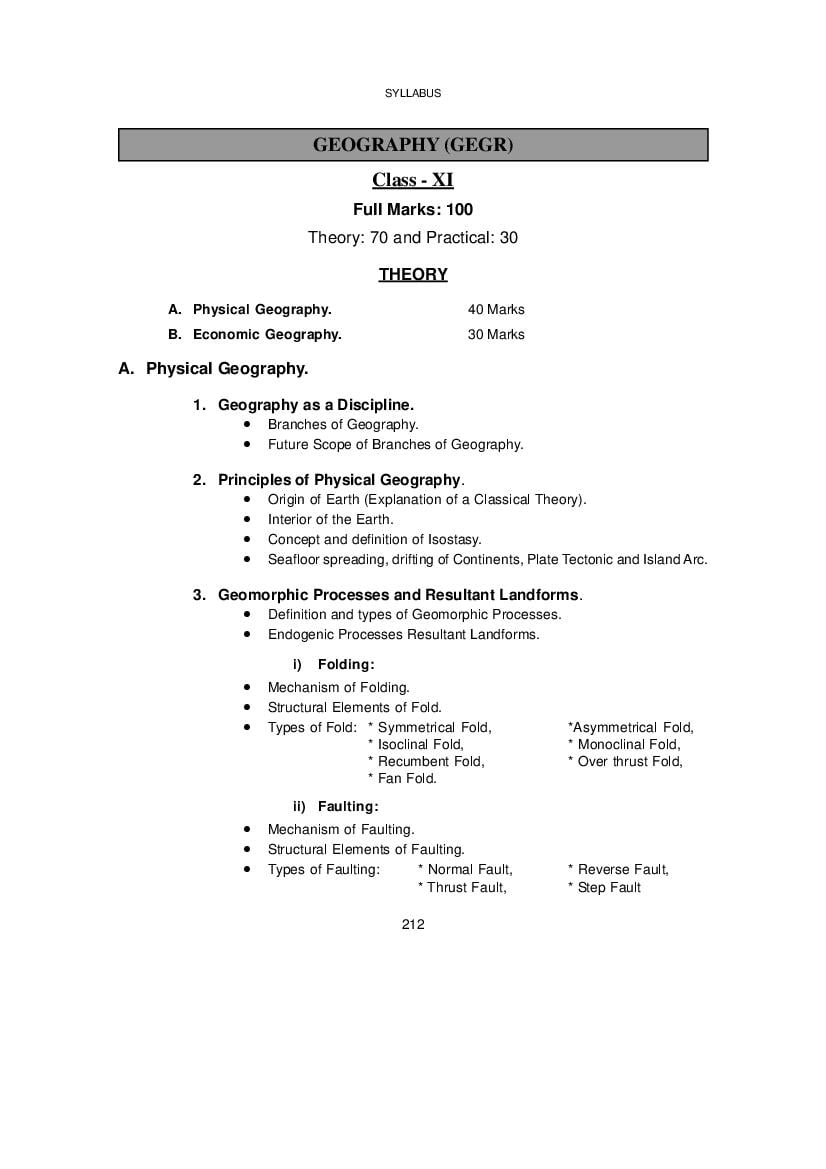
Class - XI
Full Marks: 100
Theory: 70 and Practical: 30
THEORY
A. Physical Geography. 40 Marks
B. Economic Geography. 30 Marks
A. Physical Geography.
1. Geography as a Discipline.
• Branches of Geography.
• Future Scope of Branches of Geography.
2. Principles of Physical Geography.
• Origin of Earth (Explanation of a Classical Theory).
• Interior of the Earth.
• Concept and definition of Isostasy.
• Seafloor spreading, drifting of Continents, Plate Tectonic and Island Arc.
3. Geomorphic Processes and Resultant Landforms.
• Definition and types of Geomorphic Processes.
• Endogenic Processes Resultant Landforms.
i) Folding:
• Mechanism of Folding.
• Structural Elements of Fold.
• Types of Fold: * Symmetrical Fold, *Asymmetrical Fold,
* Isoclinal Fold, * Monoclinal Fold,
* Recumbent Fold, * Over thrust Fold,
* Fan Fold.
ii) Faulting:
• Mechanism of Faulting.
• Structural Elements of Faulting.
• Types of Faulting: * Normal Fault, * Reverse Fault,
* Thrust Fault, * Step Fault
212
Page 2
• Definition and concept of Volcanicity.
• Causes of Volcanicity.
• Types of Volcanicity.
• Associated Landforms of Volcanicity: Extrusive and Intrusive.
• Concept of Volcano.
• Different parts of Volcano.
• Different types of volcanoes according to frequency of eruption.
• Distribution of World Volcanoes with special reference to Pacific Ring of
Fire.
iv) Earthquake:
• Concept and Definition of Earthquake.
• Types of Seismic Waves.
• Measuring Instruments and Scale.
• Isoseismal and Homoseismal Line.
• Causes of Earthquake (Examples from India).
• Effects of Earthquake (Examples from India).
• Distribution of Earthquake prone Zone.
• Seaquakes and Tsunamis.
• Prediction of Earthquake.
4. Hydrosphere.
i) Topography of Ocean floor:
• Major 4 divisions and others types of Ocean floor topography.
• Topography of Ocean Floor:
• Pacific Ocean,
• Atlantic Ocean
• Indian Ocean.
ii) Ocean Deposits:
• Classification of Ocean Deposits according to origin and location.
• Importance of Marine Resources:
• Mineral resources.
• Food Resources.
213
Page 3
iii) Temperature, Salinity and Density of Ocean Water:
Temperature:
• Importance of Temperature of Ocean Water.
• Process of Heating and Cooling of Ocean Water.
• Factors of Temperature Variation of Ocean Water.
• Horizontal and Vertical Distribution of Ocean Water Temperature.
Salinity:
• Concept and importance of Salinity.
• Causes of Salinity of Ocean Water.
• Distribution of Salinity of Ocean Water.
Density:
• Effects of Temperature and Salinity on Density of Ocean Water.
iv) Ocean Currents:
• Concept and Causes of Ocean Currents.
• Distribution of Ocean Currents in the Pacific Ocean.
• Distribution of Ocean Currents in the Atlantic Ocean.
• Distribution of Ocean Currents in the Indian Ocean.
• Importance of Ocean Currents.
5. Biosphere.
• Nature and Extent of Biosphere.
• Components of Biosphere.
• Concept of Ecosystem.
• Types of Ecosystem.
• Components of Ecosystem.
• Concept of Tropic Level (Food Pyramid).
• Food Web.
• Energy Flow (Energy Pyramid in Ecosystem).
B. Economic Geography.
1. Resource.
• Concept and Definition of Resource.
• Characteristics of Resource.
214
Page 4
• Resource Creating Factors (Man, Nature, Culture)
2. Utilization of World Resources.
Biotic Resource:
i) Forest.
• Types of Forests with special emphasizes on Temperate Forest,
Equatorial Forest, Mangrove Forest, Grassland.
• Forest Resources and their Conservation.
ii) Fishing.
• Concept of Fishing.
• Fishing Ground.
• Factors behind the development of Fishing Ground.
• Types of Fish.
• Methods of Fishing.
• Areas of Fishing with special reference to India, Japan and Bangladesh.
• Development of Ports and Markets depending upon Fishing.
• Fish Conservation.
• Recent Fisheries Policy of India.
iii) Land use Pattern.
• Land use Pattern of USA and Canada.
• Land use Pattern of China, Japan and Korea.
• Land use Pattern of Brazil, Chili and Argentina.
• Land use Pattern of Ukraine and Netherlands.
• Land use Pattern of South Africa.
• Land use Pattern of Australia, New Zealand and Tasmania.
iv) Water Resource: Irrigation and Water Preservation.
• Techniques of Irrigation.
• Use and Misuse of Water in Irrigation.
• Dangers of Over-watering.
• Conservation of Water Resources and Watershed Management.
• Irrigation of India, Pakistan and Egypt.
• Alternative Methods of Irrigation.
215
Page 5
• Types of Mineral Resources.
• World Distribution of Iron Ore, Copper, Manganese, Mica, Petroleum
and Natural Gas, Coal, Uranium and Thorium.
• Types of Power Resource: Conventional and Non-conventional.
• Types of Energy: Thermal, Hydroelectric and Nuclear Energy.
• World Distribution of – Hydroelectric: Canada and Scandinavian
Countries.
Thermal: India in World Respect.
Nuclear: Main Leading Countries.
• Non-conventional Energy: Solar Energy, Tidal Energy, Sea Wave
Energy, Geothermal Energy, Wind Energy, Biogas Energy, Waste-
garbage recycling Energy and others.
• Conservation of Natural Resources – Need and Method.
vi) Map Works: Showing World Distribution of Resources.
Practical
30 marks
1) Maps & Scales
a) Draw a linear scale with given R.F. (4 marks)
b) One short answer type question from maps related portion. (1 mark)
2) Cartograms
a) Draw a cartograms with the help of given data. (4 marks)
b) One short answer type question from this chaper. (1 mark)
3) Weather Instruments
a) Observation of reading of any one out of two weather instruments and write down in
a proper table. (4 marks)
b) One short answer type question from instrument oriented chaper (1 mark)
4) Interpretation of Weather map & Rainfall & Temperature Graph.
a) Interpretation of any item (pressure, wind, cloudiness. rainfall etc.)
Co-relation between any two items (pressure, wind, cloudiness, rainfall) (4 marks)
216
Page 6
OR
a) Draw a rainfall - temperature graph from given data and identify the climate type.
(4 marks)
b) Identification of any one weather symbol (1 mark)
5) Field study & viva. (3+2=5 marks)
6) Laboratory Note Book. (3+2=5 marks)
217
Document Details
| Board / Org | West Bengal Board |
| Exam | Class 11 |
| Type | Syllabus |
| Pages | 6 |
| Updated | 22 Jul 2026 |