MBOSE Class 12 Sample Question Paper 2027 Geography
Finished viewing? Save it for later —
Download MBOSE Class 12 Sample Question Paper 2027 Geography (PDF · 9 pages)About MBOSE Class 12 Sample Question Paper 2027 Geography
MBOSE Class 12 Sample Question Paper 2027 Geography is available here for free download. Published by Meghalaya Board for Class 12, this sample paper can be viewed online or downloaded as a PDF (9 pages). Candidates preparing for Class 12 can use MBOSE Class 12 Sample Question Paper 2027 Geography to understand the exam pattern, the type of questions asked, and the overall difficulty level.
Frequently Asked Questions
How can I download MBOSE Class 12 Sample Question Paper 2027 Geography?
Open this page and click the Download button to save MBOSE Class 12 Sample Question Paper 2027 Geography as a PDF. It is completely free on AglaSem Docs.
Is MBOSE Class 12 Sample Question Paper 2027 Geography free to download?
Yes. MBOSE Class 12 Sample Question Paper 2027 Geography can be viewed online and downloaded as a PDF free of cost on AglaSem Docs.
How many pages does MBOSE Class 12 Sample Question Paper 2027 Geography have?
MBOSE Class 12 Sample Question Paper 2027 Geography contains 9 pages, which you can read online or download together as a single PDF.
Where can I find more Class 12 study material?
You can find more Class 12 question papers, sample papers, syllabus, and answer keys on AglaSem Docs.
MBOSE Class 12 Sample Question Paper 2027 Geography – Text
Read the full text of this sample paper below — useful to quickly search, copy and reference the content online without downloading the PDF.
📄 View text version (10 pages)
Page 1
MBOSE Class 12
Sample Question
Paper 2027 Geography
EXAM YEAR TYPE SUBJECT
Meghalaya Class 12 2027 Sample Paper Geography
Notes · Sample Papers · Previous Year Papers · Mock Tests
Page 2
m .co
m .co s e m
se g l a
a
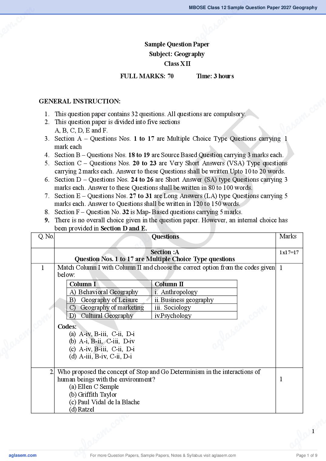
Sample Question Paper
Subject: Geography
Class XII
FULL MARKS: 70 Time: 3 hours
GENERAL INSTRUCTION:
m
m .co
.co m
1. This question paper contains 32 questions. All questions are compulsory.
m
2. This question paper is divided into five sections
s e
s e l a
ag
A, B, C, D, E and F.
l a
3. Section A – Questions Nos. 1 to 17 are Multiple Choice Type Questions carrying 1
g
a
mark each
4. Section B – Questions Nos. 18 to 19 are Source Based Question carrying 3 marks each.
5. Section C – Questions Nos. 20 to 23 are Very Short Answers (VSA) Type questions
carrying 2 marks each. Answer to these Questions shall be written Upto 10 to 20 words.
6. Section D – Questions Nos. 24 to 26 are Short Answer (SA) type Questions carrying 3
marks each. Answer to these Questions shall be written in 80 to 100 words.
7. Section E – Questions Nos. 27 to 31 are Long Answers (LA) type Questions carrying 5
marks each. Answer to Questions shall be written in 120 to 150 words.
m
.co
8. Section F – Question No. 32 is Map- Based questions carrying 5 marks.
9. There is no overall choice given in the question paper. However, an internal choice has
been provided in Section D and E.
s em
Q. No.
la
Questions
g
Marks
a Section :A 1x17=17
Question Nos. 1 to 17 are Multiple Choice Type questions
1 Match Column I with Column II and choose the correct option from the codes given 1
below:
Column I Column II
A) Behavioral Geography i. Anthropology
B) Geography of Leisure ii. Business geography
C) Geography of marketing iii. Sociology
m
m Codes: D) Cultural Geography iv.Psychology
.co
m .co s e m
s e (a) A-iv, B-iii, C-ii, D-i
g l a
la a
(b) A-i, B-ii, C-iii, D-iv
ag (c) A-iv, B-iii, C-ii, D-i
(d) A-iii, B-iv, C-ii, D-i
2. Who proposed the concept of Stop and Go Determinism in the interactions of
human beings with the environment? 1
(a) Ellen C Semple
(b) Griffith Taylor
(c) Paul Vidal de la Blache
(d) Ratzel
m .
m .co s1e
m
s e g l a
g l a a
a For more Question Papers, Sample Papers, Notes & Syllabus visit Page 1 of 9
Page 3
(a) Fertility
(b) Migration
(c) Morality Rate
(d) Natural Growth Rate
4. A town planner wants to develop a sustainable city. Which plan should be created 1
(a) Increase building without open spaces
(b) Design a city with green areas public transport, proper waste
management, and planned land use
(c) Encourage only private vehicles
(d) Allow unplanned settlement
5. Study the given graph and answer the given questions given below: 1
How does the natural increase in population occur, as per the graph?
(a) Birth Rate – Death Rate
(b) Death Rate + Birth Rate
(c) Growth Rate- Birth Rate
(d) Birth Rate – Death Rate
6. Which of the following factors determines international trade between countries? 1
(a) Population
(b) Mineral resources
(c) Foreign investment
(d) All of the above
7. Which of the following statements about modern industries is/are correct? 1
I. Modern industries require specialization in skills
II. Research and development strategies have an important role in
modern industries
Codes :
(a) Only I
(b) Only II
(c) Both I and II
(d) None of these
2
For more Question Papers, Sample Papers, Notes & Syllabus visit Page 2 of 9
Page 4
m .co
m .co s em
se g la
ASSERTION AND REASON: Direction (Q .Nos 8 a
and 9). In the questions
given below are two statements labelled as Assertion (A) and other is labelled as
Reason(R) in the context of two statements, which one of the following is
correct?
8. ASSERTION (A). Over 40% of the GDP of the country is generated 1
by tourism.
REASON (R). As a country develops, the number of people working in
m
.co
the primary sector declines whereas those in the tertiary sector increases.
m
.co
Codes:
(a) Both A and R are true and R is the correct explanation of A
e m
e m
(b) Both A and R are true, but R is not the correct explanation of A
l as
as
(c) A is true, but R is false
l ag
ag
(d) A is false, but R is true.
9. ASSERTION (A). The length and quality of roads differ greatly between 1
developed and developing countries.
REASON (R). Road construction and maintenance require heavy expenditure
Codes:
(a) Both A and R are true and R is the correct explanation of A
(b) Both A and R are true, but R is not the correct explanation of A
(c) A is true, but R is false
(d) A is false, but R is true.
om
10. Which of these objects served as a form of money initially before the 1
introduction of paper currency?
. c
Codes:
e m
I. Obsidian
las
II. Iron
III. Cloth ag
IV. Copper
V. Silver
Codes:
(a) 1, 2, 3 and 4
(b) 2, 3, 4 and 5
(c) 1, 4 and 5
(d) 2, 3, and 5
om
11. A region of Meghalaya has large deposits of limestone. Which economic activity 1
m is most likely to develop there?
. c
c. o (a) Cement industry
s e m
em a
(b) Shipbuilding industry
s (c) Fishing industry
g l
g la (d) Cotton textile industry a
a 12. The formation of various types of settlement depends upon
1. Climate
1
2. Ethnic factors
3. Security
4. Terrain
Codes:
(a) 1, 2 and 3
(b) 2, 3 and 4
(c) 2 and 3
m .
.co m
(d) All of these
s3e
e m l a
l as ag
ag For more Question Papers, Sample Papers, Notes & Syllabus visit Page 3 of 9
Page 5
rice were developed?
(a) Japan and Australia
(b) USA and Japan
(c) Mexico and Philippines
(d) Mexico and Singapore
14. Arrange the following events in history of international trade in a sequential 1
order.
1. Trade on silk route.
2. Trade expanded after the Industrial Revolution.
3. Slave trade.
4. Growth of trade between Europe and Asia.
Codes:
(a) 1, 3, 2, 4
(b) 1, 4, 3, 2
(c) 2, 1, 3, 4
(d) 1, 2, 3, 4
15. Match Column I with Column II and choose the correct option from the codes given 1
below:
Column I Column II
A) Board gauge i. 1. meter
B) Standard gauge ii. 1.5 meter or more
C) Meter gauge iii. 1.44 meter
Codes:
(a) A-i, B-ii, C-iii
(b) A-iii, B-ii, C-i
(c) A-ii, B-i, C-iii
(d) A-ii, B-iii, C-i
16. A farmer in southern Meghalaya experiences severe soil erosion every 1
monsoon. Which physical features contribute most to this problem
(a) Flat plains and low rainfall
(b) Steep slopes and heavy rainfall
(c) Desert climate
(d) Cold winters
17. If you were an urban planner, which features would you include in a “slum-free 1
city” model?
(a) Planned housing, sanitation, transportation, and employment
opportunities
(b) Uncontrolled population growth
(c) Lack of basic amenities
(d) Open dumping of waste
SECTION-B
SOURCE/GRAPH BASED QUESTIONS
4
For more Question Papers, Sample Papers, Notes & Syllabus visit Page 4 of 9
Page 6
m .co
m .co s em
se g la
a that follow:
18. Read the following passage and answer the questions 1+1+1=3
The clustered rural settlement is a compact or closely built-up area of
houses. In this type of village, the general living area is distinct and separated
from the surrounding farms, barns and pastures. The closely built-up area and its
intervening streets present some recognisable pattern or geometric shape, such as
rectangular, radial, linear, etc. Such settlements are generally found in fertile
alluvial plains and in the North-Eastern states. Sometimes, people live in
m
.co
compact village for security or defense reasons, such as in the Bundelkhand
m
.co
region of central India and in Nagaland. In Rajasthan, scarcity of water has
necessitated compact settlement for maximum utilisation of available water
e m
resources.
em l as
l asSemi-clustered or fragmented settlements may result from tendency of a
g
amayg also result
clustering in a restricted area of dispersed settlement. More often such a pattern
from segregation or fragmentation of a large compact village. In
this case, one or more sections of the village society choose or is forced to live a
little away from the main cluster or village. In such cases, generally, the land-
owning and dominant community occupies the central part of the main village,
whereas people of lower strata of society and menial workers settle on the outer
flanks of the village. Such settlements are widespread in the Gujarat plain and
some parts of Rajasthan. Sometimes settlement is fragmented into several units
m
physically separated from each other bearing a common name. These are
.co
hamletted settlements. This segmentation of a large village is often motivated by
em
social and ethnic factors.
s
a pattern in India appears in the form of
lhuts
a
isolated huts or hamlets of few g
Dispersed or isolated settlement
in remote jungles, or on small hills with
farms or pasture on the slopes. Extreme dispersion of settlement is often caused
by extremely fragmented nature of the terrain and land resource base of habitable
areas. Many areas of Meghalaya, Uttarakhand, Himachal Pradesh and Kerala
have this type of settlement.
Questions:
(i) What is the purpose of building compact or clustered settlements?
m
m (ii) Compact or clustered settlements are found in which region of India?
.co
.co m
(iii)Which type of settlement is locally known as Panna, Para, Palli, Nagla,
m Dhani in various parts of India?
s e
s e g l a
g la a
19. Study the figure given and Answer the questions that follow: 1+1+1=3
a
m .
m .co s5e
m
s e g l a
g l a a
a For more Question Papers, Sample Papers, Notes & Syllabus visit Page 5 of 9
Page 7
(i) Name any two types of land use which have registered increase between
1960–61 and 2002–03.
(ii) Name any two types of land use which have registered decline between
1960–61 and 2002–03.
(iii)Why has area under non-agricultural use increased and net sown area
decreased between 1960–61 and 2002–03?
SECTION-C 2x4=8
(Very Short Answer-type Questions)
20. Explain the concept of population density? 2
21. What is balance of trade? 2
22. Explain briefly the meaning of Hinterland. 2
23. What is meant by current fallow? 2
SECTION-D 3x3=9
Question Nos. 24 to 26 (short answer-type questions):
24. A) Examine the impact of improper land use on the environment and analyze 3
any three measures that can effectively prevent and control land pollution.
Or
B) What are the problems faced by Urban slums? 3
25. A) Indian Railways is adopting modern technology to improve its services. 3
Explain any three measures that have improved the quality of railway
transport in India.
Or
B) Distinguish between Port and Harbour. 3
26. Explain briefly the indicators used to measures Human Development. 3
SECTION-E 5x6=30
Question Nos. 27 to 31 (Long Answer – type Questions):
27. A) What do you mean by demographic transition? Discuss the three stages of 2+3=5
demographic stages of Demographic Transition.
Or
B) What is Human Development? Discuss the four approaches of human 1+4
development.
28. A) Trans- continental railways play an important role in connecting distant regions 5
of the world.
Analyze how these railways contribute to trade, economic development, and
regional integration.
6
For more Question Papers, Sample Papers, Notes & Syllabus visit Page 6 of 9
Page 8
m .co
m .co s e m
se g l a
Or a
B) Why are ports known as gate-way of international trade Explain the type of 5
ports on the basis of specialized functions?
29. A) Towns flourished since prehistoric times in India. Examine. 5
Or
B) Explain in brief the functional classification of towns in India. 5
m
.co
30. A) “Mineral distribution in India is mainly confined in the three major belts of
m
5
.co
peninsular plateaus” Support this statement with suitable examples of minerals
e m
e m
from each belt.
l as
l as Or
B) “Irrigation is needed because of spatio - temporal variability in rainfall in the
ag5
ag country”. Elucidate.
31. A) Identify the major physiographic division of Meghalaya 5
Or
B) “Meghalaya is basically an agricultural state with about 80% of its population 5
depending entirely on agriculture for their livelihood”. Write a note on the
agricultural practices of Meghalaya.
SECTION –F
Question No. 32 (Map-based Questions):
m
.co
32. On the given Political map of the world, seven geographical features have been 1x5=5
m
marked as A, B, C, D, E, F and G. Identify any five with the help of the
s e
following information and write their correct names on the lines drawn near each
feature:
g la
A. An area of nomadic herding
a
B. A major airport in South Africa
C. A canal that connects the Atlantic Ocean with the Pacific Ocean
D. The Eastern Terminal Station of the Trans-Siberian Railways
E. An area of dairy farming
F. An important inland waterway
G. An area of extensive commercial grain farming
[Important: Tear the Page containing the map and attach it with the
Answer Script]
m
m .co
.co
[The following question is for visually impaired candidates in lieu of
e m
s
questions No. 32]
e m l a
las A. Name an area of nomadic herding in South Africa a
Answer any five questions from the following: g 1x5=5
ag B. Name the major airport of South Africa.
C. Name a canal that connects the Atlantic Ocean with the Pacific Ocean.
D. Name the Eastern Terminal Station of the Trans –Siberian Railway.
E. Name an area of dairy farming in Australia.
F. Name the important inland waterway in North America.
G. Name an area of extensive commercial grain farming in North
America.
m .
m .co s7e
m
s e g l a
g l a a
a For more Question Papers, Sample Papers, Notes & Syllabus visit Page 7 of 9
Page 9
For more Question Papers, Sample Papers, Notes & Syllabus visit Page 8 of 9
Page 10
om
UNITS Objective Knowledge Understanding Application Analysis Evaluation Creation Total
c VSA O
Row
m .
Form of questions
c. o LA SA VSA O
Wise
om e m
s
Content Unit LA SA VSA O LA SA VSA O LA SA VSA O LA SA VSA O LA SA
em la
Sub Unit
1 Human Geog 1(2)
l as2(1) 1(1) ag 2
Fundamentals
ag3(1)
Geography
PART – A
2 People 1(1) 5(1) 9
of Human
3 Human Activ 1(1) 1(1) 1(1) 1(2) 8
4 Transport, 2(1) 1(2) 5(1) 9
Com. Trade
5 Human Settle 1(1) 1(1) 2
1 People 1(2) 2
2 Human Settle 5(1) 1(3) 8
3 Resources & 2(1) 1(1) 5(1) 1(3) 11
People and Economy
Devt
m
4 Transport, 2(1) 3(1) 5
PART-B
.co
Com. Intl
m
c. o5(1)
5 Geog phy 1(1) 3(1) 4
m
Perspective
em
6
c. o
Regional
s e m 5
l as
em g
Study
s
Meghalaya
g la a
la 9 a13%
7 Map Skills 1(5)
ag Sub Total 27% 19 20% 14 12 17% 10 14% 9% 6 Marks
70
Total Column 19 14 9 12 10 6 100%
wise
Notes: * Figures within brackets to indicate the number of questions and figures outside the brackets to indicate marks. * Denote that marks have been combined to form one question
Summary
LA No. 5 x 5 = 25 Marks 25 (36%) Difficult Section – A. MCQ - 1 x 17 = 17
SA No. 3 x 3 = 09 Marks 09 (24%) Average Section - B. Source Base - 1 x 6 = 06
m
.co
VSA No. 2 x 4 =08 Marks 08 (40%) Easy Section - D. SA - 3 x 3 = 09
Obj (O) No.1x28 = 28 Marks 28
m Section - C. VSA - 2 x 4 = 08
.co e m
Steps a, b, c d, e, f, g, h, I , j Section - D. SA - 3 x 3 = 09
e m Section - E. E/LA - 5 x 5 = 25
l as ag
l as Section - F. 1 x 5 = 05
ag
ag
9
For more Question Papers, Sample Papers, Notes & Syllabus visit Page 9 of 9
Document Details
| Board / Org | Meghalaya Board |
| Exam | Class 12 |
| Type | Sample Paper |
| Pages | 9 |
| Updated | 03 Nov 2026 |