HBSE Class 11 Sample Paper 2027 Geography with Marking Scheme
Finished viewing? Save it for later —
Download HBSE Class 11 Sample Paper 2027 Geography with Marking Scheme (PDF · 27 pages)About HBSE Class 11 Sample Paper 2027 Geography with Marking Scheme
HBSE Class 11 Sample Paper 2027 Geography with Marking Scheme is available here for free download. Published by Haryana Board for Class 11, this sample paper can be viewed online or downloaded as a PDF (27 pages). Candidates preparing for Class 11 can use HBSE Class 11 Sample Paper 2027 Geography with Marking Scheme to understand the exam pattern, the type of questions asked, and the overall difficulty level.
Frequently Asked Questions
How can I download HBSE Class 11 Sample Paper 2027 Geography with Marking Scheme?
Open this page and click the Download button to save HBSE Class 11 Sample Paper 2027 Geography with Marking Scheme as a PDF. It is completely free on AglaSem Docs.
Is HBSE Class 11 Sample Paper 2027 Geography with Marking Scheme free to download?
Yes. HBSE Class 11 Sample Paper 2027 Geography with Marking Scheme can be viewed online and downloaded as a PDF free of cost on AglaSem Docs.
How many pages does HBSE Class 11 Sample Paper 2027 Geography with Marking Scheme have?
HBSE Class 11 Sample Paper 2027 Geography with Marking Scheme contains 27 pages, which you can read online or download together as a single PDF.
Where can I find more Class 11 study material?
You can find more Class 11 question papers, sample papers, syllabus, and answer keys on AglaSem Docs.
HBSE Class 11 Sample Paper 2027 Geography with Marking Scheme – Text
Read the full text of this sample paper below — useful to quickly search, copy and reference the content online without downloading the PDF.
📄 View text version (28 pages)
Page 1
HBSE Class 11 Sample
Paper 2027 Geography
with Marking Scheme
EXAM YEAR TYPE SUBJECT
Haryana Class 11 2027 Sample Paper Geography
Notes · Sample Papers · Previous Year Papers · Mock Tests
Page 2
.co s e m
s em l a
a ag
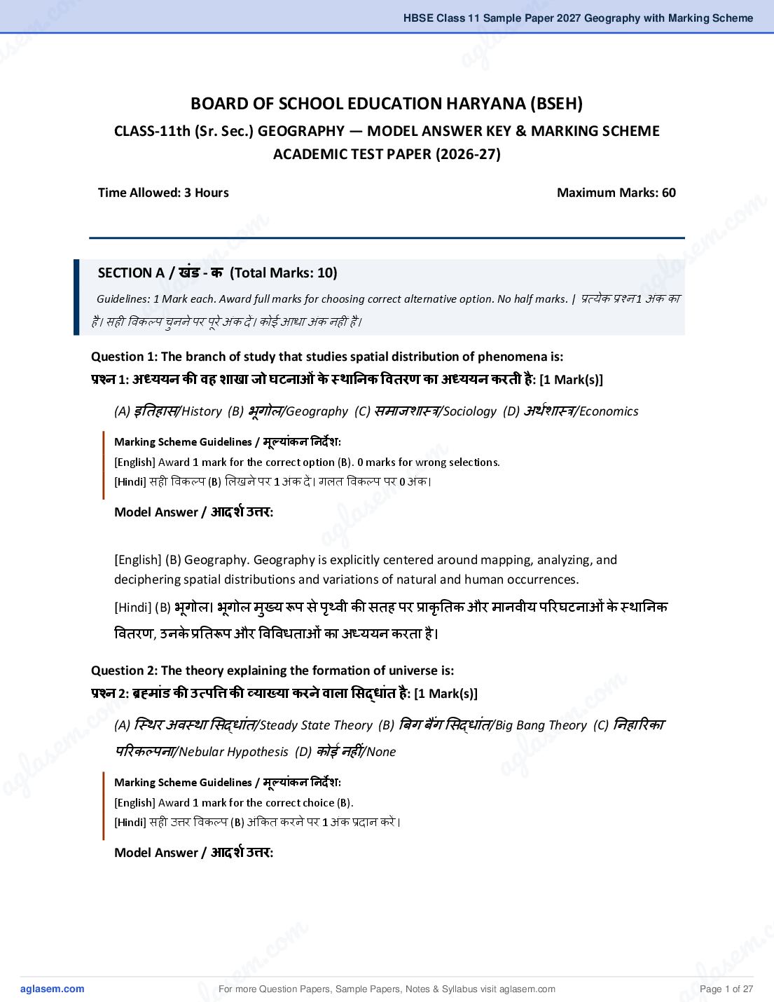
BOARD OF SCHOOL EDUCATION HARYANA (BSEH)
CLASS-11th (Sr. Sec.) GEOGRAPHY — MODEL ANSWER KEY & MARKING SCHEME
ACADEMIC TEST PAPER (2026-27)
Time Allowed: 3 Hours Maximum Marks: 60
m
om . co
. c em
e m
SECTION A / खॊड - क (Total Marks: 10) l as
as g
l ्ऺत्मेक ्ऺश्न a
a g
Guidelines: 1 Mark each. Award full marks for choosing correct alternative option. No half marks. |
है । सही विकल्ऩ चुनने ऩय ऩूये अॊक दें । कोई आधा अॊक नहीॊ है ।
1 अॊक का
Question 1: The branch of study that studies spatial distribution of phenomena is:
्ቚश्न 1: अध्ययन की वह शाखा जो घटनाओॊ के स्थाननक ववतरण का अध्ययन करती है : [1 Mark(s)]
(A) इततहास/History (B) बूगोर/Geography (C) सभाजशा़्र/Sociology (D) अथथशा़्र/Economics
m
.co
[English] Award 1 mark for the correct option (B). 0 marks for wrong selections.
[Hindi] सही विकल्ऩ (B) लरखने ऩय 1 अॊक दें । गरत विकल्ऩ ऩय 0 अॊक।
e m
l a s
a g
[English] (B) Geography. Geography is explicitly centered around mapping, analyzing, and
deciphering spatial distributions and variations of natural and human occurrences.
[Hindi] (B) बग
ू ोर। बग
ू ोर भख्
ु म रूऩ से ऩथ्
ृ िी की सतह ऩय ्ऺाकृततक औय भानिीम ऩरयघटनाओॊ के ़्थातनक
वितयण, उनके ्ऺततरूऩ औय विविधताओॊ का अध्ममन कयता है ।
Question 2: The theory explaining the formation of universe is:
m
.co
्ቚश्न 2: ्ቜहमाॊड की उत्ऩव्ቈ की व्याख्या करने वाऱा ससदधाॊत है : [1 Mark(s)]
m
c. o (A) स़््थय अि़्था लसदधाॊत/Steady State Theory (B) बफग फैंग लसदधाॊत/Big Bang sTheory
e m (C) तनहारयका
s em ऩरयकल्ऩना/Nebular Hypothesis (D) कोई नहीॊ/None g l a
la a
ag Marking Scheme Guidelines / मूलयाॊकन ननदे श:
[English] Award 1 mark for the correct choice (B).
[Hindi] सही उ्ቈय विकल्ऩ (B) अॊककत कयने ऩय 1 अॊक ्ऺदान कयें ।
m . c
c. o s e m
s em
For more Question Papers, Sample Papers, Notes & Syllabus visit
gl a
Page 1 of 27
Page 3
high-density and high-temperature state roughly 13.8 billion years ago.
[Hindi] (B) बफग फैंग लसदधाॊत। मह सिथभान्म िैऻातनक लसदधाॊत फताता है कक ़्हभाॊड की उत्ऩव्ቈ रगबग 13.8
बफलरमन िर्थ ऩि
ू थ एक अत्मधधक सघन औय गभथ एकर बफॊद ु से ती्व वि़्ताय के कायण हुई थी।
Question 3: The process of breakdown of rocks in situ is called:
्ቚश्न 3: चट्टानों का स्थान ऩर ही टूटना कहऱाता है : [1 Mark(s)]
(A) अऩयदन/Erosion (B) अऩऺम/Weathering (C) तनऺेऩण/Deposition (D) सॊहतत ऺम/Mass wasting
[English] Award 1 mark for option (B). No marks for transport-based concepts like erosion.
[Hindi] सही विकल्ऩ (B) के लरए 1 अॊक दें । अऩयदन जैसे गततशीर विकल्ऩों ऩय शून्म अॊक दें ।
[English] (B) Weathering. Weathering involves mechanical disintegration and chemical
decomposition of minerals on site (in situ) without lateral transportation.
[Hindi] (B) अऩऺम। अऩने ही भर
ू ़्थान (़्थातनक रूऩ से) ऩय फाहम कायकों के ्ऺबाि से चट्टानों के टूटने-
पूटने औय विखॊडडत होने की ्ऺकिमा अऩऺम कहराती है । इसभें ऩरयिहन शालभर नहीॊ होता।
Question 4: The layer where ozone is concentrated:
्ቚश्न 4: वह ऩरत जहाॉ ओजोन कें्शित होती है : [1 Mark(s)]
(A) ऺोबभॊडर/Troposphere (B) सभताऩभॊडर/Stratosphere (C) भध्मभॊडर/Mesosphere (D)
ताऩभॊडर/Thermosphere
[English] Award 1 mark for selecting (B) Stratosphere.
[Hindi] सही विकल्ऩ (B) चुनने ऩय 1 अॊक ्ऺदान कयें ।
[English] (B) Stratosphere. The stratosphere contains the ozonosphere, located primarily between
15 and 35 km altitude, which screens out lethal solar ultraviolet radiation.
[Hindi] (B) सभताऩभॊडर। ओजोन ऩयत का भख्
ु म सॊकें्शण सभताऩ भॊडर भें (धयातर से रगबग 15 से 35
ककभी के फीच) ऩामा जाता है , जो सम
ू थ की हातनकायक ऩयाफैंगनी ककयणों को सोखती है ।
For more Question Papers, Sample Papers, Notes & Syllabus visit Page 2 of 27
Page 4
.co s e m
s em l a
a ag
Question 5: The highest peak in India is:
्ቚश्न 5: भारत की सबसे ऊॉची चोटी है : [1 Mark(s)]
(A) नॊदा दे िी/Nanda Devi (B) कॊचनजॊगा/Kanchenjunga (C) गुरुलशखय/Gurushikhar (D) एिये ़्ट/Everest
m
co
[English] Award 1 mark for correct selection of (B) Kanchenjunga.
om .
[Hindi] सही उ्ቈय विकल्ऩ (B) कॊचनजॊगा लरखने ऩय 1 अॊक दें ।
. c e m
e m l as
a s
l Kanchenjunga. Situated on the India-Nepal frontier in Sikkim, Kanchenjunga standsaatg
[English]g(B)
a
8,586 meters and is the highest peak inside the undisputed administrative territory of India. *(Note:
K2/Godwin Austen is higher at 8,611m but lies in Pakistan-Occupied Kashmir).*
[Hindi] (B) कॊचनजॊगा। मह लसस्ककभ भें बायत-नेऩार सीभा ऩय स़््थत है औय इसकी ऊॊचाई 8,586 भीटय है । मह
ितथभान भें बायत के ऩण
ू थ ्ऺशासतनक तनमॊरण िारे ऺेर की सिोच्च चोटी है ।
Question 6: The river that forms the largest delta in India:
m
्ቚश्न 6: भारत में सबसे बडा डेलटा बनाने वाऱी नदी है : [1 Mark(s)]
o
c
. (D) भहानदी/Mahanadi
m
(A) गोदाियी/Godavari (B) कृष्णा/Krishna (C) गॊगा/Ganga
e
l a
Marking Scheme Guidelines / मूलयाॊकन ननदे श:s
a g
[English] Award 1 mark for selecting option (C).
[Hindi] सही उ्ቈय विकल्ऩ (C) गॊगा चुनने ऩय 1 अॊक आिॊटटत कयें ।
[English] (C) Ganga. The Ganga, combined with the Brahmaputra, discharges into the Bay of Bengal,
building the highly extensive Sundarbans Delta, the largest delta network worldwide.
[Hindi] (C) गॊगा। गॊगा नदी अऩने भह
ु ाने ऩय ़्हभऩर
ु के साथ लभरकय फॊगार की खाडी भें विश्ि के सफसे फडे m
m .co
.co
डेल्टा 'सद
ुॊ यिन डेल्टा' का तनभाथण कयती है ।
e m
l as
em Question 7: The discontinuity between crust and mantle is called ____________.
s g
la ्ቚश्न 7: भऩू ऩशटी और ्ቚावार के बीच की असतता ________________ कहऱाती हैa। [1 Mark(s)]
ag Marking Scheme Guidelines / मूलयाॊकन ननदे श:
[English] Award 1 mark for providing 'Mohorovicic' or 'Moho' discontinuity. Allow phonetic adjustments in spelling.
[Hindi] उ्ቈय भें 'भोहोयोविककक' मा 'भोहो असतता' लरखने ऩय 1 अॊक दें । ितथनी भें थोडी रटु ट ़्िीकामथ है ।
m . c
c. o s e m
s em
For more Question Papers, Sample Papers, Notes & Syllabus visit
gl a
Page 3 of 27
Page 5
boundary between the Earth's thin rock crust and the dense stony silicate mantle layer.
[Hindi] भोहोयोविककक असतता (मा भोहो असतता)। मह ऩयत बऩ
ू ऩथटी (ि़्ट) के तनचरे टह़्से औय ऊऩयी भें टर
(्ऺािाय) के भध्म चट्टानी घनत्ि भें लबन्नता के कायण बक
ू ॊ ऩीम तयॊ गों की गतत भें आने िारे फदराि को दशाथती
है ।
Question 8: The study of earthquakes is called ____________.
्ቚश्न 8: भक
ू ॊ ऩों का अध्ययन ____________ कहऱाता है । [1 Mark(s)]
[English] Award 1 mark for 'Seismology' or 'बूकॊऩ विऻान'.
[Hindi] उ्ቈय 'लस़्भोरॉजी' मा 'बूकॊऩ विऻान' होने ऩय 1 अॊक दें ।
[English] Seismology. It constitutes the specialized geophysics sub-discipline that evaluates the
release of energy and propagation of elastic seismic waves through planet interiors.
[Hindi] लस़्भोरॉजी (मा बक
ू ॊ ऩ विऻान)। मह ब-ू विऻान की िह शाखा है स्जसके अॊतगथत बक
ू ॊ ऩीम तयॊ गों के
उदबि, ्ऺसाय औय उनके ्ऺबािों का िैऻातनक अध्ममन ककमा जाता है ।
Question 9: Assertion: Himalayas are young fold mountains.
Reason: They are formed due to collision of Indian and Eurasian plates.
्ቚश्न 9: असभकथन् ्शहमाऱय नवीन वसऱत ऩवशत हैं।
कारण् ये भारतीय और यरू े सशयाई प्ऱेटों के टकराव से बने हैं। [1 Mark(s)]
(A) Only assertions is correct (B) Only reason is correct (C) Both are correct & Reason explains
Assertion (D) Both are correct but not related
[English] Award 1 mark for option (C). The causal link between plate tectonics and fold mountains must be
recognized.
[Hindi] सही विकल्ऩ (C) के लरए 1 अॊक दें । विितथतनक प्रेटों के टकयाि औय िलरत ऩिथतों के फीच के कायण-कामथ सॊफॊध को
सभझना आिश्मक है ।
[English] (C) Both Statements are correct. Statement II (Reason) correctly explains Statement I
(Assertion). The active dynamic northward movement and subsequent continental subduction of
the Indian Plate beneath the Eurasian Plate buckled the sedimentary layers of the ancient Tethys
Sea, pushing up the folded Himalayan range.
For more Question Papers, Sample Papers, Notes & Syllabus visit Page 4 of 27
Page 6
.co s e m
s em l a
a ag
[Hindi] (C) दोनों सही हैं तथा कायण (R), कथन (A) को सही ढॊ ग से ़्ऩष्ट कयता है । बायतीम विितथतनक प्रेट के
उ्ቈय की ओय गततशीर होने तथा मयू े लशमाई प्रेट से टकयाने के कायण ्ऺाचीन टे धथस सागय भें जभा अिसादों भें
िरन (Folding) ऩड गमा, स्जससे टहभारम का जन्भ हुआ।
Question 10: Assertion: Monsoon winds change direction seasonally.
m
co
Reason: Differential heating of land and sea causes monsoon.
्ቚश्न 10: असभकथन् मानसन m मौसमी रूऩ से ्शदशा बदऱती हैं।
ू oऩवनें
m .
. cअसमान ताऩन मानसन का कारण है। [1 Mark(s)] s e
कारण् स्थऱ और समि
s eु mका ू
g l a
g l a is correct (B) Only reason is correct (C) Both are correct & Reason explains a
(A) Only assertions
a (D) Both are correct but not related
Assertion
[English] Award 1 mark for option (C).
[Hindi] सही उ्ቈय विकल्ऩ (C) अॊककत कयने ऩय 1 अॊक दें ।
m
.co
[English] (C) Both Statements are correct. Statement II (Reason) correctly explains Statement I
(Assertion). The unequal heat retention capability of continental landmasses compared to expansive
e m
s
water bodies induces sharp shifting thermal pressure centers, forcing complete seasonal reversals in
atmospheric winds.
l a
ag (A) को सही ढॊग से ़्ऩष्ट कयता है। विशार ़्थरीम बबू ागों औय
[Hindi] (C) दोनों सही हैं तथा कायण (R), कथन
विशार जरसागयों के गभथ ि ठॊ डे होने की दय भें अॊतय होने के कायण िामद
ु ाफ ऩेटटमों का भौसभी वि़्थाऩन होता
है , जो भानसन
ू हिाओॊ के उत्िभण का भर
ू कायण है ।
SECTION B / खॊड - ख (Total Marks: 12)
Guidelines: 2 Marks each. Length: 20-30 words. Award 1 mark for core definition and 1 mark for explanatory elaboration
m
or examples. | ्ऺत्मेक ्ऺश्न 2 अॊक का है । उ्ቈय सीभा: 20 से 30 शब्द। भूर ऩरयबार्ा के लरए 1 अॊक औय अततरयकत विियण/उदाहयण
m .co
.co
के लरए 1 अॊक दें ।
e m
e m las
s
Question 11: Define geography as a discipline.
la ्ቚश्न 11: भग
ू ोऱ को एक अनश
ु ासन के रूऩ में ऩररभावषत करें । [2 Mark(s)] ag
ag Marking Scheme Guidelines / मूलयाॊकन ननदे श:
[English] Award 1 mark for the concept of 'spatial distribution/earth surface analysis' and 1 mark for highlighting
'human-environment integration'.
[Hindi] ़्थातनक वितयण/ऩथ्ृ िी सतह के विश्रेर्ण' की अिधायणा के लरए 1 अॊक औय 'भानि-ऩमाथियण अॊत्सॊफॊधों' का उल्रेख
कयने के लरए 1 अॊक दें ।
m . c
c. o s e m
s em
For more Question Papers, Sample Papers, Notes & Syllabus visit
gl a
Page 5 of 27
Page 7
mapping how physical processes and human civilizations distribute, vary, and influence each other
interactively.
[Hindi] बग
ू ोर एक एकीकृत ़्थातनक विऻान (spatial science) है जो ऩथ्
ृ िी की सतह के रऺणों का अध्ममन
कयता है । मह इस फात का अन्िेर्ण कयता है कक बौततक औय भानिीम कायक ककस ्ऺकाय वितरयत औय ऩय़्ऩय
्ऺबावित होते हैं।
Question 12: Name two direct sources to study Earth’s interior.
्ቚश्न 12: ऩथ्
ृ वी के आॊतररक भाग के अध्ययन के दो ्ቚत्यऺ ्ቨोत बताइए। [2 Mark(s)]
[English] Award 1 mark per valid source named. Max 2 marks. Indirect sources like seismic waves score zero if
mentioned here.
[Hindi] ्ऺत्मेक सही ्ቨोत का नाभ फताने ऩय 1 अॊक दें (अधधकतभ 2 अॊक)। मटद महाॉ बूकॊऩीम तयॊ गों जैसे अ्ऺत्मऺ ्ቨोतों का
उल्रेख ककमा गमा है , तो अॊक न दें ।
[English] The two major direct pathways are:
[Hindi] दो भख्
ु म ्ऺत्मऺ ्ቨोत तनम्नलरखखत हैं:
• Deep Mining and Crustal Drilling Projects: Extracting raw rock core samples from ultra-deep
boreholes (e.g., Kola Superdeep Borehole).
गहयी खदानें औय बू-ऩऩथटीम िेधन (Drilling): गहये फोयहोर से चट्टानों के नभूने तनकारना (जैसे कोरा सुऩयडीऩ
फोयहोर)।
• Volcanic Material Eruptions: Inspecting hot un-solidified magma thrown directly onto the Earth's
surface from subsurface layers.
ज्िाराभुखी से तनकरे ऩदाथथ: आॊतरयक ऩयतों से सीधे सतह ऩय आए वऩघरे हुए भैग्भा का ्ऺत्मऺ ्ऺमोगशारा ऩयीऺण
कयना।
Question 13: What are neap tides?
्ቚश्न 13: ज्वार-भाटा क्या होते हैं? (ऱघु ज्वार क्या हैं?) [2 Mark(s)]
[English] Award 1 mark for referencing the right-angle alignment (90°) of the Moon-Sun-Earth, and 1 mark for
stating that it leads to lower-than-average high tides.
[Hindi] सूम-थ चॊ्शभा-ऩथ्ृ िी के सभकोणीम सॊयेखण (90°) का उल्रेख कयने के लरए 1 अॊक, तथा मह साभान्म से कभ ऊॊचे ज्िाय का
कायण फनता है , मह फताने के लरए 1 अॊक दें ।
For more Question Papers, Sample Papers, Notes & Syllabus visit Page 6 of 27
Page 8
.co s e m
s em l a
a ag
[English] Neap tides are unusually low-amplitude tides that take place twice a month when the Sun
and Moon form a right angle (90°) relative to Earth. Their opposing gravitational pulls pull in
different directions, minimizing water rise.
[Hindi] रघु ज्िाय (Neap Tides) तफ आते हैं जफ सम
ू थ औय चॊ्शभा ऩथ्
ृ िी के कें्श ऩय सभकोण (90°) की स़््थतत भें o m
m
o कृष्ण ऩऺ की सप्तभी मा अष्टभी को होता है। विऩयीत गरुु त्िाकर्थण फरों के कायण em . c
होते हैं। ऐसा शकु र ऩऺ.cऔय
इस सभम सफसे e mऊॊचाई िारे ज्िाय आते हैं।
कभ l as
l as ag
agWhat is biodiversity?
Question 14:
्ቚश्न 14: जैव ववववधता क्या है ? [2 Mark(s)]
[English] Award 1 mark for identifying 'variety of life forms' and 1 mark for mentioning its levels (genetic, species, or
ecological levels).
[Hindi] जीिों की ्ऺजाततमों की विविधता' की ऩहचान के लरए 1 अॊक औय इसके ़्तयों (अनुिाॊलशक मा ऩारयस़््थततक ़्तय) का
उल्रेख कयने के लरए 1 अॊक दें ।
m
m .co
e
s and evolutionary variation of living organisms—
l a
g species differences, and systemic community
[English] Biodiversity describes the entire richness
a
comprising genetic variability within species,
ecosystem diversity in a given habitat.
[Hindi] जैि विविधता से तात्ऩमथ ककसी तनस्श्चत ऩमाथियण मा सॊऩण
ू थ ऩथ्
ृ िी ऩय ऩाए जाने िारे जीिों की विलबन्न
्ऺजाततमों, उनके बीतय की आनि
ु लॊ शक लबन्नताओॊ औय विलबन्न ्ऺकाय के ऩारयस़््थततक तॊरों की सभ्ቇ सभद
ृ धध
से है ।
m
Question 15: Name any two physiographic divisions of India.
्ቚश्न 15: भारत के ककनहीॊ दो भौनतक ववभागों के नाम बताइए। [2 Mark(s)]
m .co
m .co Marking Scheme Guidelines / मूलयाॊकन ननदे श:
s e m
s e g
[English] Award 1 mark for each correctly identified physical division (up to 2 marks).
la
g la [Hindi] ्ऺत्मेक सही बौततक विबाग का नाभ फताने ऩय 1 अॊक दें (अधधकतभ 2 अॊक)। a
a Model Answer / आदशश उ्ቈर:
[English] Any two major divisions are required:
[Hindi] ककन्हीॊ दो ्ऺभख
ु बौततक विबागों का उल्रेख कयें :
m . c
c. o s e m
s em
For more Question Papers, Sample Papers, Notes & Syllabus visit
gl a
Page 7 of 27
Page 9
उ्ቈयी औय उ्ቈय-ऩि
ू ी ऩिथत श्ॊख
ृ राएॊ (विशार टहभारम ऩिथत)।
• The Vast Northern Plains (The fertile Indo-Gangetic alluvial trough).
उ्ቈय बायत का विशार भैदान (लसॊधु-गॊगा-़्हभऩुर का उऩजाऊ भैदान)।
• *(Accept other valid divisions: Peninsular Plateau, Coastal Plains, Great Indian Desert, or Islands).*
*(अन्म भान्म विबाग बी ़्िीकामथ हैं: ्ऺामदिीऩीम ऩठाय, तटीम भैदान, थाय भरु़्थर, मा दिीऩ सभूह)।*
OR / अथवा (Question 15 Alternate Choice)
Question 15 (ALT): What is the importance of Himalayas?
्ቚश्न 15 (ALT): ्शहमाऱय का महत्व क्या है ? [2 Mark(s)]
[English] Award 1 mark for mentioning 'climatic barrier effect' and 1 mark for 'source of perennial rivers/monsoon
rainfall initiation'.
[Hindi] जरिामु अियोधक ्ऺबाि' का उल्रेख कयने के लरए 1 अॊक औय 'सदािाटहनी नटदमों का ्ቨोत / भानसूनी िर्ाथ' के लरए 1
अॊक दें ।
[English] The Himalayas act as an impermeable climatic barrier shield protecting India from hyper-
cold Siberian wind vectors, trigger rainy summer monsoons, and supply a continuous water volume
to perennial North Indian rivers.
[Hindi] टहभारम बायत के लरए एक भजफत
ू जरिामु अियोधक का कामथ कयता है जो भध्म-एलशमा की फपीरी
हिाओॊ को योकता है , भानसन
ू ी हिाओॊ को योककय दे श भें िर्ाथ कयाता है , औय उ्ቈय बायत की सदािाटहनी नटदमों
को ग्रेलशमय वऩघरने से जर ्ऺदान कयता है ।
Question 16: What is ‘bhabar’ and ‘tarai’?
्ቚश्न 16: ‘भाबर’ और ‘तराई’ क्या हैं? [2 Mark(s)]
[English] Award 1 mark for defining 'Bhabar' as a porous pebble zone and 1 mark for defining 'Tarai' as the swampy
zone where rivers resurface.
[Hindi] बाफय को कॊकड-मुकत ऩायगम्म ऺेर फताने के लरए 1 अॊक औय तयाई को उस दरदरी ऺेर के रूऩ भें ऩरयबावर्त कयने के
लरए 1 अॊक दें जहाॉ नटदमाॉ ऩुन् ्ऺकट होती हैं।
[English] Bhabar is a dry pebble-heavy zone along the Himalayan foothills where descending
mountain streams drop gravel and sink below the surface. Tarai lies directly south of Bhabar; it is a
wet, marshy low-lying belt where those submerged streams resurface.
For more Question Papers, Sample Papers, Notes & Syllabus visit Page 8 of 27
Page 10
.co s e m
s em l a
a ag
[Hindi] बाफय टहभारम की लशिालरक तरहटी भें भोटे कॊकड-ऩत्थयों से तनलभथत एक सॊकयी ऩट्टी है जहाॉ नटदमाॉ
बग
ू बथ भें रप्ु त हो जाती हैं। तयाई, बाफय के द्ቌऺण भें स़््थत एक दरदरी औय अत्मधधक नभी िारा ऺेर है जहाॉ
रप्ु त नटदमाॉ धयातर ऩय ऩन
ु ् ्ऺकट हो जाती हैं।
OR / अथवा (Question 16 Alternate Choice)
m
m . co
c. o को ऩररभावषत करें। [2 Mark(s)]
Question 16 (ALT): Define natural vegetation.
्ቚश्न 16 (ALT): ्ቚाकृनतक वनस्ऩनत e m
em l as
s
la ag
ag
[English] Award 1 mark for 'growing naturally without human help' and 1 mark for highlighting its prolonged
adaptive isolation ('virgin vegetation').
[Hindi] बफना भानिीम सहामता के ्ऺाकृततक रूऩ से उगने' के लरए 1 अॊक औय इसके दीघथकालरक अनुकूरन ('अऺत िऩ्ऩतत')
को ये खाॊककत कयने के लरए 1 अॊक दें ।
[English] Natural vegetation refers to an organic plant community that grows completely naturally
m
.co
over a prolonged period without human planting, care, or modification, adjusting freely to local soil
and environmental parameters.
e m
s
[Hindi] ्ऺाकृततक िऩ्ऩतत से तात्ऩमथ ऩौधों औय िऺ
ृ ों के उस सभद
laउगता
ु ाम से है जो बफना ककसी भानिीम सहामता,
ह़्तऺेऩ मा योऩण के ्ऺाकृततक ऩरयस़््थततमोंgभें है औय रॊफे सभम तक िहाॊ की जरिामु औय लभट्टी के
अनक ु ू र खद
ु को ढार रेता है ।
a
SECTION C / खॊड - ग (Total Marks: 18)
Guidelines: 3 Marks each. Length: 50-70 words. Structured point-wise marking: Allocate 1 mark per distinct, logically
supported point (total 3 points required). | ्ऺत्मेक ्ऺश्न 3 अॊक का है । उ्ቈय सीभा: 50 से 70 शब्द। बफॊदि
ु ाय भूल्माॊकन कयें : ्ऺत्मेक
ताककथक औय ़्ऩष्ट बफॊदु के लरए 1 अॊक दें (कुर 3 बफॊदु अतनिामथ)।
m
m
c.्ቚश्नo 17: भगू ोऱ को एक अनशु ासन के रूऩ में महत्व समझाइए। [3 Mark(s)]
Question 17: Explain the importance of geography as a discipline.
m .co
m s e
s e g la
la
g a
a [English] Award 1 mark per distinct point detailing analytical, environmental, or technological importance.
[Hindi] विश्रेर्णात्भक, ऩमाथियणीम मा तकनीकी भहत्ि का विियण दे ने िारे ्ऺत्मेक लबन्न बफॊद ु के लरए 1 अॊक दें (अधधकतभ 3
अॊक)।
m . c
c. o s e m
s em
For more Question Papers, Sample Papers, Notes & Syllabus visit
gl a
Page 9 of 27
Page 11
policy. Its fundamental importance rests upon:
[Hindi] बग
ू ोर सभकारीन ़्थातनक जागरूकता औय बलू भ उऩमोग नीतत के लरए एक अत्मॊत भहत्िऩण
ू थ विर्म
है । इसका भहत्ि तनम्नलरखखत तीन बफॊदओ
ु ॊ भें ़्ऩष्ट है :
• Spatial Distribution Analysis: It tracks how global land assets, agricultural soils, and populations are
spread, helping handle economic inequalities.
़्थातनक वितयण का विश्रेर्ण: मह मह सभझने भें भदद कयता है कक िैस्श्िक सॊसाधन, उऩजाऊ लभट्टी औय
जनसॊख्मा ककस ्ऺकाय वितरयत हैं, स्जससे आधथथक असभानताओॊ को दयू कयने भें सहामता लभरती है ।
• Resource and Hazard Management: It combines environmental sciences with physical setups to
evaluate natural disasters, mitigate climate hazards, and organize sustainable development.
सॊसाधन औय आऩदा ्ऺफॊधन: मह ्ऺाकृततक आऩदाओॊ (फाढ़, सख
ू ा) के शभन, ऩमाथियण सॊयऺण औय सतत विकास की
मोजना फनाने के लरए िैऻातनक आधाय तैमाय कयता है ।
• Geo-Spatial Technology Integration: It builds specialized vocational expertise in highly essential
analytical tools including digital map-making, Remote Sensing, and Geographic Information Systems
(GIS).
बू-़्थातनक ्ऺौदमोधगकी का अनु्ऺमोग: मह आधुतनक शहयी तनमोजन के लरए आिश्मक उऩकयणों जैसे डडस्जटर
भानधचरण, सुदयू सॊिेदन (Remote Sensing) औय बौगोलरक सूचना ्ऺणारी (GIS) के उऩमोग का कौशर ्ऺदान कयता है ।
Question 18: Describe the origin of Earth according to Big Bang Theory.
्ቚश्न 18: बबग बैंग ससदधाॊत के अनस
ु ार ऩथ्
ृ वी की उत्ऩव्ቈ का वणशन करें । [3 Mark(s)]
[English] Award 1 mark for describing the initial cosmic explosion, 1 mark for nebular formation, and 1 mark for the
accretion of matter forming planets ~4.6 billion years ago.
[Hindi] ्ऺायॊ लबक ़्हभाॊडीम वि़्पोट के विियण के लरए 1 अॊक, तनहारयका तनभाथण के लरए 1 अॊक, औय रगबग 4.6 बफलरमन िर्थ
ऩूिथ ्ቇहों के तनभाथण के लरए 1 अॊक दें ।
[English] The Big Bang framework links the origin of the Earth to chronological stages of cosmic
expansion and matter accretion:
[Hindi] बफग फैंग लसदधाॊत ऩथ्
ृ िी की उत्ऩव्ቈ को ़्हभाॊडीम वि़्ताय औय ऩदाथथ के िलभक सॊघनन के चयणों से
जोडता है :
• The Primordial Explosion: Around 13.8 billion years ago, a dense singular energy point exploded. This
massive expansion triggered rapid cooling, allowing energy to transform into subatomic particles and
lightweight gases.
For more Question Papers, Sample Papers, Notes & Syllabus visit Page 10 of 27
Page 12
.co s e m
s em l a
a ag
्ऺायॊ लबक भहावि़्पोट: रगबग 13.8 बफलरमन िर्थ ऩि
ू ,थ एक अत्मॊत सघन बफॊद ु भें भहावि़्पोट हुआ। इस वि़्ताय से
ताऩभान भें धगयािट आई औय ऊजाथ उऩ-ऩयभाणु कणों ि गैसों भें फदर गई।
• Nebular Condensation: Gravitational forces gradually pulled together vast clouds of hydrogen and
helium gas into rotating interstellar dust clouds called nebulas.
तनहारयका (Nebula) का तनभाथण: गरु
ु त्िाकर्थण फर के कायण सभम के साथ हाइ्ቑोजन औय हीलरमभ गैसों के विशार
फादर आऩस भें जुडकय घूभती हुई विशार तनहारयकाओॊ भें फदर गए। o m
m
o Inside our local solar nebula, rotating gaseous material separated into dense em . c
. c
• Planetesimal Accretion:
billion years ago, the central core collapsed into the Sun, while surrounding particle s
e
rings. Around 4.6 m l a
s
a ि अलबिदृ धध: हभायी सौय तनहारयका के बीतय, घूभते हुए भरफे के छल्रे सॊघतनत हुए। रगबग 4.6a
lविकास
rings accreted to form planets, including the Earth. g
g
्ቇहों का
a
बफलरमन िर्थ ऩूि,थ कें्शीम बाग सूमथ फना औय उसके चायों ओय घूभते धूर औय गैस के कण आऩस भें जुडकय ऩथ् ृ िी सटहत
अन्म ्ቇहों भें फदर गए।
Question 19: Differentiate between weathering and erosion.
्ቚश्न 19: अऩऺय और अऩरदन में अॊतर स्ऩष्ट करें । [3 Mark(s)]
m
.co
[English] Award 1 mark for highlighting static vs dynamic nature, 1 mark for contrasting their driving agents, and 1
mark for distinguishing their geomorphic effects.
e m
[Hindi] ़्थैततक फनाभ गततशीर ्ऺकृतत को ये खाॊककत कयने के लरए 1 अॊक, उनके ्ऺेयक कायकों भें अॊतय के लरए 1 अॊक, औय उनके
l as
बू-आकृततक ्ऺबािों भें अॊतय ़्ऩष्ट कयने के लरए 1 अॊक दें ।
Model Answer / आदशश उ्ቈर: ag
[English] Weathering and erosion work in tandem to shape landscapes but are distinct physical
operations:
[Hindi] अऩऺम औय अऩयदन दोनों लभरकय ब-ू आकृततमों को फदरते हैं, रेककन दोनों की कामथ्ऺणारी भें ़्ऩष्ट
अॊतय है :
m
m .co
• Static vs. Dynamic Process: Weathering is entirely an 'in situ' (on site) static mechanism where rocks
m .co em
break down mechanically or chemically right where they rest. Erosion is a dynamic process where rock
s
e la्ऺकिमा है स्जसभें चट्टानें
debris is explicitly dislodged, moved, and transported across distances.
las ़्थैततक फनाभ गततशीर ्ऺकिमा: अऩऺम एक ऩण थ ् ़्ि-़्थातनक (in-situ) मा ़्थैg
ू त
a ततक
ag बफना ककसी गतत के अऩने ही ़्थान ऩय टूटती हैं। अऩयदन एक गततशीर ्ऺकिमा है स्जसभें चट्टानी भरफे को सकिम रूऩ
से हटामा औय दयू रे जामा जाता है ।
• Driving Force and Agents: Weathering is triggered by atmospheric variables like temperature
changes, frost action, water presence, and chemical reactions. Erosion requires kinetic natural agents
like running water, wind, moving glaciers, or coastal waves.
सॊचारक फर औय कायक: अऩऺम भुख्म रूऩ से िामुभॊडरीम कायकों (ताऩभान भें उताय-चढ़ाि, ऩारा, यासामतनक घोर)
m . c
c. o s e m
s em
For more Question Papers, Sample Papers, Notes & Syllabus visit
gl a
Page 11 of 27
Page 13
आिश्मक है ।
• Topographic Role: Weathering loosens up solid rock structures and prepares loose material, whereas
erosion actively scours the bedrock to form new landforms (such as deep river canyons or glacial
valleys).
धयातरीम बूलभका: अऩऺम ठोस चट्टानों को कभजोय कय भरफे को हटने के लरए तैमाय कयता है , जफकक अऩयदन
अॊततनथटहत चट्टान को काटकय नई घाटटमों मा बू-आकृततमों का तनभाथण कयता है ।
Question 20: Explain the composition and structure of atmosphere.
्ቚश्न 20: वायम
ु ड
ॊ ऱ की सॊरचना और सॊघटन समझाइए। [3 Mark(s)]
[English] Award 1.5 marks for accurate details of gases/composition, and 1.5 marks for listing the correct sequential
thermal layers.
[Hindi] गैसों/सॊघटन के सटीक विियण के लरए 1.5 अॊक, औय िामुभॊडर की सही िलभक ऩयतों को सूचीफदध कयने के लरए 1.5
अॊक दें ।
[English] The atmosphere forms a layered protective gas shield around Earth, defined by its precise
structural arrangement:
[Hindi] िामभ
ु ड
ॊ र ऩथ्
ृ िी के चायों ओय ऩामा जाने िारा एक फहु़्तयीम गैसीम आियण है , स्जसे इसकी अनठ
ू ी
व्मि़्था दिाया सभझा जा सकता है :
• Chemical Composition: It consists of a stable blend of primary permanent gases (Nitrogen 78%,
Oxygen 21%, Argon 0.93%, and Carbon Dioxide 0.04%), along with highly variable amounts of water
vapor and suspended fine aerosol dust particles.
गैसीम सॊघटन (Composition): मह ़्थामी गैसों (नाइ्ोजन 78%, ऑकसीजन 21%, आगथन 0.93%, काफथन
डाइऑकसाइड 0.04%), तथा ऩरयितथनशीर जरिाष्ऩ औय तैयते हुए सष्
ू भ धर
ू कणों (एयोसोर) का लभश्ण है ।
• Thermal Structure Layers: Based on temperature variations at changing altitudes, it is stratified into
five distinct vertical layers starting from the ground up: (1) Troposphere, (2) Stratosphere, (3)
Mesosphere, (4) Thermosphere, and (5) Exosphere.
ताऩीम ऩयतदाय सॊयचना (Structure): ऊॊचाई के साथ ताऩभान भें फदराि के आधाय ऩय, इसे नीचे से ऊऩय ऩाॉच ऩयतों भें
विबास्जत ककमा गमा है : (1) ऺोबभॊडर, (2) सभताऩभॊडर, (3) भध्मभॊडर, (4) ताऩभॊडर, औय (5) फाहमभॊडर।
Question 21: Describe the drainage system of North India.
्ቚश्न 21: उ्ቈर भारत की जऱ ननकासी ्ቚणाऱी का वणशन करें । [3 Mark(s)]
[English] Award 1 mark per core characteristic: perennial nature, alpine erosional landforms, and flat plain
depositional systems.
For more Question Papers, Sample Papers, Notes & Syllabus visit Page 12 of 27
Page 14
.co s e m
s em l a
a ag
[Hindi] ्ऺत्मेक भुख्म विशेर्ता के लरए 1 अॊक दें : सदािाटहनी ्ऺकृतत, ऩिथतीम अऩयदनात्भक आकृततमाॉ, औय भैदानी तनऺेऩण
्ऺणालरमाॉ।
[English] The North Indian drainage landscape is primarily dominated by the major Indus, Ganga,
m
om
and Brahmaputra river river networks. Its central operational features are:
. co
. c
[Hindi] उ्ቈय बायत की जर तनकासी ्ऺणारी भख्
ु म रूऩ से लसॊधु, गॊगा औय ़्हभऩर
ु नदी ्ऺणालरमों दिाया e m
m
eभख्ु म विशेर्ताएॊ इस ्ऺकाय हैं: l as
s
तनलभथत है । इसकी
a
l Flow Regime: These rivers maintain water flow year-round because they receive watera g
a g
• Perennial
from rainfall during the summer monsoon and from melting glaciers in high alpine zones during hot
seasons.
सदािाटहनी जर ्ऺिाह (Perennial Nature): मे नटदमाॉ िर्थ बय जर से बयी यहती हैं कमोंकक इन्हें िर्ाथ के अततरयकत
गलभथमों भें टहभारम के टहभनदों (glaciers) के वऩघरने से रगाताय ऩानी लभरता यहता है ।
• Youthful Mountain Topography: In their high-altitude upper paths, they execute rapid vertical
erosion, slicing down steep slopes to forge rugged gorges, V-shaped valleys, and massive rapids.
मि
m
ु ा ऩिथतीम ़्थराकृततमाॉ: अऩने ऩिथतीम ऩहाडी भागों भें मे नटदमाॉ ती्व गतत से ऊध्िाथधय काट-छाॉट कयती हैं, स्जससे
गहये गॉजथ, िी-आकाय की घाटटमाॉ औय झयने फनते हैं।
m .co
s e
a
• Mature Plain Depositional Features: Upon entering flat plains, they transition to lateral movement,
l
ag
depositing huge silt volumes that create extensive river meanders, oxbow lakes, and broad fertile
deltas.
भैदानी बागों भें तनऺेऩण: भैदानी इराकों भें ्ऺिेश कयने ऩय इनकी गतत धीभी हो जाती है , स्जससे मे विसऩथ
(meanders), गोखुय झीरें औय विशार उऩजाऊ डेल्टा (जैसे सुॊदयिन) फनाती हैं।
OR / अथवा (Question 21 Alternate Choice)
Question 21 (ALT): Explain the factors affecting Indian climate.
्ቚश्न 21 (ALT): भारतीय जऱवायु को ्ቚभाववत करने वाऱे कारकों की व्याख्या करें । [3 Mark(s)]
m
m .co
.co
e m
e m las
[English] Award 1 mark for each major climatic control factor explained clearly, up to a maximum of 3 marks.
[Hindi] ़्ऩष्ट रूऩ से सभझाए गए ्ऺत्मेक भुख्म जरिामु तनमॊरण कायक के लरए 1 अॊक दें (अधधकतभ 3 अॊक)।
las ag
ag Model Answer / आदशश उ्ቈर:
[English] The Indian monsoon sub-continental climate is regulated by multiple interacting
geographical controls:
[Hindi] बायतीम उऩभहादिीऩ की भानसन
ू ी जरिामु कई भहत्िऩण
ू थ बौगोलरक कायकों दिाया तनमॊबरत होती है :
m . c
c. o s e m
s em
For more Question Papers, Sample Papers, Notes & Syllabus visit
gl a
Page 13 of 27
Page 15
subtropical northern areas. Simultaneously, elevation differences keep high-altitude zones cool even
at low latitudes.
अऺाॊश औय सभु्श तर से ऊॉचाई: ककथ ये खा बायत को दो बागों भें फाॊटती है , स्जससे द्ቌऺण भें उष्णकटटफॊधीम औय उ्ቈय
भें उऩ-उष्णकटटफॊधीम स़््थततमाॊ फनती हैं। साथ ही, अधधक ऊॊचाई के कायण ऩिथतीम ऺेर ठॊ डे यहते हैं।
• The Himalayan Shield and Oceans: The northern mountain range protects the country from Arctic
winds while trapping monsoon rains. Meanwhile, the surrounding Indian Ocean regulates coastal
temperatures and supplies moisture.
टहभारम ऩिथत औय भहासागय: उ्ቈय भें स़््थत टहभारम साइफेरयमाई ठॊ डी हिाओॊ को योकता है औय भानसन
ू को दे श से
फाहय जाने नहीॊ दे ता। दस
ू यी ओय, टहॊद भहासागय तटीम ताऩभान को तनमॊबरत कयता है औय नभी ्ऺदान कयता है ।
• Jet Streams and Air Pressure Movements: Upper-atmosphere pressure changes, the shifting of the
ITCZ, and winter jet streams control the sudden onset of summer monsoons and winter storms.
जेट ़््ीभ औय िामभ
ु ॊडरीम दफाि: ऊऩयी िामभ
ु ॊडर की जेट ़््ीभ, आईटीसीजेड (ITCZ) का भौसभी वि़्थाऩन औय
ऩस्श्चभी विऺोब गलभथमों के भानसून के आगभन औय सटदथ मों की िर्ाथ को तनमॊबरत कयते हैं।
Question 22: Discuss the causes and effects of floods in India.
्ቚश्न 22: भारत में बाढ़ के कारणों और ्ቚभावों की चचाश करें । [3 Mark(s)]
[English] Award 1.5 marks for discussing the core causes and 1.5 marks for detailing both the destructive and
constructive consequences.
[Hindi] फाढ़ के भुख्म कायणों ऩय चचाथ कयने के लरए 1.5 अॊक औय इसके विनाशकायी ि यचनात्भक दोनों ्ऺबािों का विियण दे ने के
लरए 1.5 अॊक दें ।
[English] Floods represent severe recurring seasonal hydro-meteorological hazards in India's major
plains:
[Hindi] फाढ़ बायत के भैदानी इराकों भें फाय-फाय आने िारी एक गॊबीय औय विनाशकायी भानसन
ू ी जर-भौसभ
िैऻातनक आऩदा है :
• Primary Causes: Heavy and highly concentrated rainfall over short periods during the summer
monsoon; rapid accumulation of riverbed silt that lowers water capacity; and extensive deforestation
in upper catchment areas.
भुख्म कायण: भानसून के दौयान फहुत कभ सभम भें अत्मधधक भूसराधाय िर्ाथ होना; नदी के तरों भें गाद (silt) जभा
होने से नदी की जर िहन ऺभता का घटना; औय ऩिथतीम ढारों ऩय िनों की अॊधाधुॊध कटाई।
• Destructive Effects: Significant loss of human life and livestock; destruction of standing crops and
physical infrastructure; major economic dislocation; and post-flood waterborne diseases.
For more Question Papers, Sample Papers, Notes & Syllabus visit Page 14 of 27
Page 16
.co s e m
s em l a
a ag
विनाशकायी ्ऺबाि: फडे ऩैभाने ऩय भानि जीिन औय ऩशुधन की हातन; खडी पसरों औय फतु नमादी ढाॊचे का विनाश;
राखों रोगों का वि़्थाऩन औय फाढ़ के फाद जरजतनत भहाभारयमों का ्ऺकोऩ।
• Constructive Effect (Exception): Annual floods deposit rich layers of fertile river silt, which naturally
restores nutrients to floodplain soils and supports agriculture over the long term.
सकायात्भक ्ऺबाि (अऩिाद): फाढ़ के कायण हय सार खेतों भें नई उऩजाऊ जरोढ़ लभट्टी जभा होती है , जो ्ऺाकृततक रूऩ
m
से लभट्टी की उिथयता फढ़ाती है औय दीघथकालरक कृवर् को राब ऩहुॉचाती।
om Choice) . co
OR / अथवा (Question 22.cAlternate
e m
m
eWrite l as
l a
Question 22 (ALT):s a note on natural vegetation of India.
ag
ag भारत की ्ቚाकृनतक वनस्ऩनत ऩर एक ्शटप्ऩणी सऱखें। [3 Mark(s)]
्ቚश्न 22 (ALT):
[English] Award 1 mark for each major vegetation ecosystem zone described along with its matching rainfall
characteristics, up to 3 marks.
[Hindi] िर्ाथ की विशेर्ताओॊ के साथ िखणथत ्ऺत्मेक भुख्म िऩ्ऩतत ऺेर के लरए 1 अॊक ्ऺदान कयें (अधधकतभ 3 अॊक)।
m
.co
[English] India's varied regional rainfall and complex terrain produce a diverse range of natural
m
vegetation zones across the subcontinent:
[Hindi] बायत भें िर्ाथ की भारा भें अत्मधधक ्ऺादेa
e
s लबन्नता औय विविध उच्चािच के कायण महाॉ विलबन्न
l लशक
्ऺकाय के िऩ्ऩतत ऺेर ऩाए जाते हैं: ag
• Tropical Evergreen Forests: Located in warm, high-precipitation areas (>200 cm annual rainfall) like
the Western Ghats and the Northeast. These forests feature a dense canopy and stay green year-
round.
उष्णकटटफॊधीम सदाफहाय िन: मे अत्मधधक िर्ाथ (>200 सेभी िावर्थक िर्ाथ) औय गभथ ऺेरों जैसे ऩस्श्चभी घाट औय
ऩूिो्ቈय बायत भें ऩाए जाते हैं। मे िन फहुत घने होते हैं औय िर्थ बय हये -बये टदखते हैं।
• Tropical Deciduous Forests: The most widespread forest network across India, receiving 70 to 200
m
m .co
.co
cm of rainfall. These forests are divided into moist and dry zones, with economically valuable trees like
m
Teak and Sal shedding leaves in dry seasons.
s em
s e la
उष्णकटटफॊधीम ऩणथऩाती िन: मे बायत के सफसे व्माऩक िन हैं, जो 70 से 200 सेभी िर्ाथ ्ऺाप्त कयने िारे ऺेरों भें लभरते
ृ aशgुष्क भौसभ भें अऩनी ऩव्ቈमाॊ धगया
g la हैं। मे आ्शथ औय शुष्क दो बागों भें फॊटे हैं। इनभें सागौन औय सार जैसे भूल्मिान िऺ
a दे ते हैं।
• Arid Thorn Forests and Mountainous Cover: Low-rainfall zones (<50 cm) contain deep-rooted, thorny
scrub vegetation. In contrast, high-altitude mountain regions feature coniferous trees and alpine
pastures that change distinctly with elevation.
m . c
c. o s e m
s em
For more Question Papers, Sample Papers, Notes & Syllabus visit
gl a
Page 15 of 27
Page 17
इसके विऩयीत, टहभारम के ऩिथतीम ऺेरों भें ऊॊचाई के साथ फदरते शॊकुधायी िन औय अल्ऩाइन चयागाह लभरते हैं।
SECTION D / खॊड - घ (Total Marks: 15)
Guidelines: 5 Marks each. Detailed comprehensive essays required (150-170 words). Structured split scoring: Award 2
marks for conceptual foundational frameworks and 3 marks for descriptive analytical points or evidence. | ्ऺत्मेक ्ऺश्न 5
अॊक का है । वि़्तत
ृ िणथनात्भक तनफॊधात्भक उ्ቈय अतनिामथ (150 से 170 शब्द)। अॊक विबाजन: सॊकल्ऩनात्भक ढाॊचे के लरए 2 अॊक
औय वि़्तत
ृ विश्रेर्णात्भक बफॊदओ
ु ॊ मा साष्मों के लरए 3 अॊक दें ।
Question 23: Explain Wegener’s Continental Drift Theory with evidences.
्ቚश्न 23: वेगेनर के महादवीऩीय ववस्थाऩन ससदधाॊत को साष्यों स्शहत समझाइए। [5 Mark(s)]
[English] Award 2 marks for explaining Pangea, Panthalassa, and the core concept of drifting. Award 3 marks for
describing at least 3 distinct pieces of empirical evidence clearly (1 mark per evidence).
[Hindi] ऩैनस्जमा, ऩैंथारसा औय वि़्थाऩन की भूर अिधायणा को सभझाने के लरए 2 अॊक दें । कभ से कभ 3 अरग-अरग साष्मों
को ़्ऩष्ट रूऩ से सभझाने के लरए 3 अॊक दें (्ऺत्मेक साष्म के लरए 1 अॊक)।
[English] Alfred Wegener introduced his 'Continental Drift Theory' in 1912 to explain how the
world's oceans and continents took shape over geological history. Wegener proposed that around
200 million years ago, all global landmasses were joined together as a single massive supercontinent
called 'Pangea,' which was surrounded by a single vast ocean named 'Panthalassa.' Over time,
Pangea broke apart into two large northern and southern landmasses—Laurasia and
Gondwanaland. These pieces then drifted continuously across the globe until they reached their
current positions. To support his claims, Wegener gathered several compelling pieces of cross-
continental evidence:
1. The Matching of Shorelines (Jigsaw Fit): The Atlantic coastlines of South America and Western
Africa show a remarkable, interlocking fit when placed together, like pieces of a puzzle.
2. Geological Strata Continuity: Radiometric dating reveals that ancient rock belts along the coast of
Brazil match up in age (~2,000 million years) and structure with rock belts in West Africa.
3. Glacial Tillite Deposits: Layers of tillite, a sedimentary rock formed from glacial debris, show
matching patterns across Gondwana landmasses, including India, Africa, Madagascar, Antarctica,
and Australia, pointing to a shared past climate.
4. Coastal Placer Deposits: The Ghana coast contains rich gold placer deposits despite having no
local source rocks. However, matching gold-bearing quartz veins are found directly across the ocean
in Brazil, showing the landmasses were once joined.
5. Intercontinental Fossil Distribution: Identical fossil remains of the small freshwater reptile
For more Question Papers, Sample Papers, Notes & Syllabus visit Page 16 of 27
Page 18
.co s e m
s em l a
a ag
Mesosaurus and the land plant Glossopteris are found only on the now widely separated coasts of
South America and Southern Africa, showing these lands were once connected.
[Hindi] अल्रेड िेगेनय ने 1912 भें भहासागयों औय भहादिीऩों के िैस्श्िक वितयण औय उनकी ऐततहालसक
गततशीरता को सभझाने के लरए 'भहादिीऩीम वि़्थाऩन लसदधाॊत' का ्ऺततऩादन ककमा। िेगेनय के अनस
ु ाय,
रगबग 200 लभलरमन िर्थ ऩि
ू थ सॊसाय के सबी बब
ू ाग आऩस भें जुडे हुए थे औय एक विशार भहा-भहादिीऩ
m
om
'ऩैनस्जमा' (Pangea) के रूऩ भें थे, जो चायों ओय से 'ऩैंथारसा' (Panthalassa) नाभक एक भहा-भहासागय से तघया . co
. c e m
हुआ था। ब-ू गलबथक फरों के कायण ऩैनस्जमा का विखॊडन शरू
e m ु हुआ औय मह दो फडे टह़्सों—उ्ቈयी बाग
as
'रॉये लशमा' औयsद्ቌऺणी बाग 'गोंडिानारैंड' भें टूट गमा। इसके फाद मे खॊड विलबन्न टदशाओॊ भें ्ऺिाटहत होतेgहlु ए
g a
lान ़्थानों ऩय ऩहुॉचे। िेगेनय ने अऩने इस लसदधाॊत को साबफत कयने के लरए तनम्नलरखखत अकाट्मa
a
अऩने ितथ भ
साष्म ्ऺ़्तत
ु ककए:
1. भहादिीऩों की तटये खाओॊ भें साम्मता (Jigsaw Fit): द्ቌऺण अभेरयका के ऩि
ू ी तट औय ऩस्श्चभी अरीका के
ऩस्श्चभी तट को मटद आऩस भें लभरामा जाए, तो िे एक ऩहे री के टुकडों की तयह आऩस भें बफल्कुर कपट हो जाते
हैं।
o m
2. भहासागयों के ऩाय सभान आमु की चट्टानें: अत्माधुतनक ये डडमोभेट्क डेटटॊग ऩदधतत से ऩता चरता है कक
c
़्ाजीर के तट ऩय ऩाई जाने िारी 2,000 लभलरमन िर्थ ऩयु .ानी ्ऺाचीन चट्टानों की ऩट्टी ऩस्श्चभी अरीका के तट
e m
ऩय भौजदू चट्टानों से भेर खाती है ।
l as
ag टहभनद तनऺेऩों से फनी तरछटी चट्टानें हैं। बायत के गोंडिाना
3. टटराइट तनऺेऩ (Tillite Deposits): टटराइट
श्ेणी के तरछटों के सभान ्ऺततरूऩ सद
ु यू द्ቌऺण अरीका, फॉकरैंड, भेडागा़्कय, अॊटाकथटटका औय ऑ़््े लरमा भें
ऩाए जाते हैं, जो उनके एक सभम साथ यहने का ्ऺभाण हैं।
4. प्रेसय तनऺेऩों की सभानता: अरीका के घाना तट ऩय सोने के सभद
ृ ध प्रेसय तनऺेऩ ऩाए जाते हैं, रेककन िहाॊ
सोने की कोई भर
ू चट्टानें नहीॊ हैं। इसके विऩयीत, सोने की भर
ू लशयाएॊ सीधे सभ्श
ु ऩाय ़्ाजीर भें लभरती हैं,
स्जससे लसदध होता है कक मे तट ऩहरे आऩस भें जड
ु े थे।
m
m 5. जीिाश्भों का िैस्श्िक वितयण: भीठे ऩानी भें यहने िारे 'भेसोसॉयस' नाभक छोटे सयीसऩ
.co
ृ औय 'ग्रोसोप्टे रयस'
c. o नाभक ऩौधे के जीिाश्भ केिर द्ቌऺण अभेरयका औय द्ቌऺण अरीका के सदु यू तटीम ऺेsरोंeभेंmऩाए जाते हैं, जो
s em उनके ऩयु ाने बलू भ जुडाि को ऩष्ु ट कयते हैं। g l a
la a
ag OR / अथवा (Question 23 Alternate Choice)
Question 23 (ALT): Describe the structure of the interior of Earth with a labeled diagram.
्ቚश्न 23 (ALT): नामाॊककत चच्ቔ स्शहत ऩथ्
ृ वी के आॊतररक भाग की सॊरचना का वणशन करें । [5 Mark(s)]
[English] Award 3 marks for describing the three core layers (Crust, Mantle, Core) accurately with structural
m . c
c. o s e m
s em
For more Question Papers, Sample Papers, Notes & Syllabus visit
gl a
Page 17 of 27
Page 19
[Hindi] तीनों भुख्म ऩयतों (ि़्ट, भें टर, कोय) का सॊयचनात्भक आमाभों के साथ सटीक िणथन कयने के लरए 3 अॊक दें । ऩथ्ृ िी की
आॊतरयक ऩयतों का एक साप औय नाभाॊककत ये खाधचर फनाने के लरए 2 अॊक दें ।
[English] By studying seismic wave velocities and changes in material density, scientists have divided
the interior of the Earth into three main layers:
1. The Crust: This is the solid, brittle, outermost layer of the Earth. Its thickness ranges from just 5
km beneath ocean floors (composed of basaltic Sima—Silica and Magnesium) to 30–50 km under
continents (composed of granitic Sial—Silica and Aluminium). The average density of this layer is
between 2.7 and 3.0 g/cm³.
2. The Mantle: This layer begins at the Moho discontinuity and extends down to a depth of 2,900
km, making up about 84% of the Earth's total volume. Its upper section (down to 400 km) is the
Asthenosphere, a semi-fluid layer that serves as the main source of magma for volcanic eruptions.
The density of the mantle increases with depth, ranging from 3.4 to 5.5 g/cm³.
3. The Core: The core stretches from 2,900 km deep all the way to the center of the Earth at 6,371
km. It is divided into two parts: a liquid Outer Core (kept fluid by extreme heat) and a solid Inner
Core (kept solid by immense pressure from the layers above). The core is often called the 'Nife' layer
because it is made primarily of Nickel (Ni) and Iron (Fe). It has an extremely high density, ranging
from 10 to 13 g/cm³.
*[Evaluator Note: For full marks, the student must draw a clear concentric circular or pie-slice
diagram on their answer sheet. The diagram should clearly label the Crust, Mantle, Asthenosphere,
Outer Core, Inner Core, and the Moho and Gutenberg discontinuities].*
[Hindi] बक
ू ॊ ऩीम तयॊ गों की गतत के विश्रेर्ण, घनत्ि के अॊतय औय यासामतनक फनािट के आधाय ऩय ऩथ्
ृ िी की
आॊतरयक सॊयचना को तीन भख्
ु म सॊकेंट्शत ऩयतों भें विबास्जत ककमा गमा है :
1. बऩ
ू ऩथटी (Crust): मह ऩथ्
ृ िी की सफसे फाहयी, ठोस औय बॊगयु ऩयत है । इसकी भोटाई भहासागयीम तनतर के
नीचे केिर 5 ककभी (लसलरका औय भैग्नीलशमभ से तनलभथत 'लसभा') से रेकय भहादिीऩों के नीचे 30 से 50 ककभी
(लसलरका औय एल्मलु भतनमभ से तनलभथत 'लसमार') तक ऩाई जाती है । इसका औसत घनत्ि 2.7 से 3.0 g/cm³ है ।
2. भें टर / ्ऺािाय (Mantle): मह भोहो असतता से शरू
ु होकय 2,900 ककभी की गहयाई तक पैरा हुआ है , जो ऩथ्
ृ िी
के कुर आमतन का रगबग 84% बाग फनाता है । भें टर का ऊऩयी टह़्सा (400 ककभी की गहयाई तक) 'दफ
ु र
थ ता
भॊडर' (Asthenosphere) कहराता है , जो ज्िाराभख
ु ी उदगाय के सभम भैग्भा का ्ऺाथलभक ्ቨोत फनता है ।
इसका घनत्ि गहयाई के साथ 3.4 से 5.5 g/cm³ तक फढ़ता है ।
3. िोड / कोय (Core): मह 2,900 ककभी से रेकय ऩथ्
ृ िी के कें्श (6,371 ककभी) तक वि़्तत
ृ है । इसे दो बागों भें
For more Question Papers, Sample Papers, Notes & Syllabus visit Page 18 of 27
Page 20
.co s e m
s em l a
a ag
विबास्जत ककमा गमा है : फाहम कोय (अत्मधधक ताऩभान के कायण तयर अि़्था भें ) औय आॊतरयक कोय (ऊऩयी
बायी दफाि के कायण ठोस अि़्था भें )। मह भख्
ु म रूऩ से तनकेर (Ni) औय रोहे (Fe) जैसी बायी धातओ
ु ॊ से फना है ,
इसलरए इसे 'तनपे' (Nife) बी कहा जाता है । इसका घनत्ि सिाथधधक 10 से 13 g/cm³ होता है ।
*[भल्
ू माॊकन तनदे श: ऩण
ू थ अॊक ्ऺाप्त कयने के लरए छार को उ्ቈय ऩस्ु ़्तका ऩय ि़्ट, भें टर, ए़्थेनो़्पीमय,
m
om
फाहम ि आॊतरयक कोय औय भोहो ि गट
ु े नफगथ असतताओॊ को ़्ऩष्ट रूऩ से दशाथता हुआ एक सॊकेंट्शत ि्ቈ
ृ मा ऩाई- . co
. c em
़्राइस का ये खाधचर फनाना अतनिामथ है ।]*
em l as
l as ag
्ቚश्न 24: भa
g
Question 24: Discuss the geomorphic processes responsible for landform development.
ू - आकृनत ननमाशण के सऱए उ्ቈरदायी भू - आकृनतक ्ቚकियाओॊ की चचाश करें । [5 Mark(s)]
[English] Award 2.5 marks for explaining Endogenic forces (diastrophism and volcanism) and 2.5 marks for
explaining Exogenic forces (weathering, mass wasting, erosion, and deposition).
[Hindi] अॊतजथतनत फरों (ऩटर विरूऩण औय ज्िाराभुखी किमा) को सभझाने के लरए 2.5 अॊक औय फटहजथतनक फरों (अऩऺम,
िहृ द ऺयण, अऩयदन औय तनऺेऩण) को सभझाने के लरए 2.5 अॊक दें ।
Model Answer / आदशश उ्ቈर: m
m .co
s e
a
[English] Geomorphic processes are the physical and chemical actions that continuously shape and
l
ag
modify the surface of the Earth. These forces are broadly divided into two main categories:
Endogenic (internal) and Exogenic (external) processes.
1. Endogenic Processes: Driven by radioactivity, geothermal energy, and rotation deep within the
Earth, these processes act as 'land-building' forces that create structural relief. They include:
- Diastrophism: Slow, constructive movements that include Orogenic forces (which build
mountains through folding and faulting) and Epeirogenic forces (which cause large-scale continental
uplift or sinking).
- Volcanism: Sudden, dramatic movements that push molten magma onto the surface, forming
m
m volcanic peaks, plateaus, and unique rock structures.
c. o 2. Exogenic Processes: Operating on the Earth's surface, these forces derive theirmenergy from solar .co
s e
s em radiation and gravity. They act as 'land-wearing' or leveling forces that flatten
g l a features over time.
la a
ag
They include:
- Weathering: The static breaking down and decomposition of rocks in one place (in situ) through
mechanical, chemical, or biological actions.
- Mass Wasting: The downward movement of rock debris along slopes due purely to gravity,
without the help of water or ice.
- Erosion and Deposition: The active scraping, transport, and accumulation of rock material carried
out by dynamic natural agents like running water, wind, glaciers, and coastal waves.
m . c
c. o s e m
s em
For more Question Papers, Sample Papers, Notes & Syllabus visit
gl a
Page 19 of 27
Page 21
ृ िी की सतह के
़्िरूऩ औय फनािट भें तनयॊ तय ऩरयितथन राती हैं। इन शस्कतमों को भख्
ु म रूऩ से दो ्ऺभख
ु श्ेखणमों भें विबास्जत
ककमा गमा है : अॊतजथतनत (आॊतरयक) ्ऺकिमाएॊ औय फटहजथतनक (फाहयी) ्ऺकिमाएॊ।
1. अॊतजथतनत ्ऺकिमाएॊ (Endogenic Processes): मे ऩथ्
ृ िी के आॊतरयक बाग भें उत्ऩन्न होने िारी ब-ू ताऩीम
ऊजाथ, ये डडमोधलभथता औय घण
ू न
थ फरों से सॊचालरत होती हैं। मे धयातर ऩय विर्भताओॊ का तनभाथण कयती हैं,
इसलरए इन्हें धयातर-तनभाथणकायी फर (Land-building forces) बी कहा जाता है । इनभें शालभर हैं:
- ऩटर विरूऩण (Diastrophism): मे अत्मॊत भॊद औय यचनात्भक गततमाॊ होती हैं, स्जनभें ऩिथत तनभाथणकायी
फर (िरन औय ्ऽॊशन दिाया ऩिथतों का तनभाथण) तथा भहादिीऩ तनभाथणकायी फर (विशार बब
ू ागों का उत्थान मा
अितरन) शालभर हैं।
- ज्िाराभख
ु ी किमा (Volcanism): मे आकस़््भक गततमाॊ होती हैं स्जसके तहत वऩघरा हुआ भैग्भा धयातर को
तोडकय फाहय आता है औय ज्िाराभख
ु ी ऩिथतों ि ऩठायों का तनभाथण कयता है ।
2. फटहजथतनक ्ऺकिमाएॊ (Exogenic Processes): मे ्ऺकिमाएॊ ऩथ्
ृ िी की फाहयी सतह ऩय कामथ कयती हैं, जो भख्
ु म
रूऩ से सम
ू थ की गभी (सौय विककयण) औय गरु
ु त्िाकर्थण से ऊजाथ ्ऺाप्त कयती हैं। मे धयातर की विर्भताओॊ को दयू
कय सभतर ़्थावऩत कयने का कामथ कयती हैं (Land-wearing forces)। इनभें शालभर हैं:
- अऩऺम (Weathering): माॊबरक, यासामतनक मा जैविक किमाओॊ दिाया चट्टानों का अऩने ही ़्थान ऩय
टूटना-पूटना।
- िह
ृ द ऺयण (Mass Wasting): ककसी गततशीर भाध्मभ के बफना केिर गरु
ु त्िाकर्थण के सीधे ्ऺबाि के कायण
भरफे का ढार के सहाये नीचे की ओय खखसकना।
- अऩयदन औय तनऺेऩण: गततशीर ्ऺाकृततक कायकों जैसे फहते जर, ऩिन, टहभनद औय सभ्श
ु ी रहयों दिाया
चट्टानों को काटना, उनका ऩरयिहन कयना औय अॊतत् उन्हें तनचरे बागों भें जभा कयना।
OR / अथवा (Question 24 Alternate Choice)
Question 24 (ALT): Explain the distribution of oceans and continents in light of plate tectonics.
्ቚश्न 24 (ALT): प्ऱेट वववतशननकी के आऱोक में महासागरों और महादवीऩों के ववतरण की व्याख्या करें । [5 Mark(s)]
[English] Award 2 marks for explaining the core concept of lithospheric plates and driving mantle convection
currents. Award 3 marks for describing how divergent, convergent, and transform boundaries shape continents and
oceans (1 mark per boundary type).
[Hindi] ़्थरभॊडरीम प्रेटों औय भेंटर सॊिहन धायाओॊ की भूर अिधायणा को सभझाने के लरए 2 अॊक दें । अऩसायी, अलबसायी
औय रूऩाॊतय सीभाओॊ दिाया भहादिीऩों ि भहासागयों के तनधाथयण को सभझाने के लरए 3 अॊक दें (्ऺत्मेक सीभा ्ऺकाय के लरए 1
अॊक)।
For more Question Papers, Sample Papers, Notes & Syllabus visit Page 20 of 27
Page 22
.co s e m
s em l a
a ag
[English] The theory of Plate Tectonics, developed in the late 1960s, provides the most
comprehensive and modern scientific explanation for how continents and oceans are distributed.
According to this theory, the Earth's rigid outer shell (lithosphere) is fractured into 7 major and
m
co
several minor rigid blocks called Tectonic Plates. These plates float over the hot, semi-fluid
om
asthenosphere below, driven by thermal convection currents rising from deep within the mantle.
. c e m .
e m
The positions and changing shapes of continents and oceans are determined by how these plates
l as
a s
interact along three types of boundaries:
a g
l Boundaries (Constructive): Here, tectonic plates pull away from each other. This mostly
a g
1. Divergent
occurs along Mid-Oceanic Ridges (such as the Mid-Atlantic Ridge), where magma rises up to fill the
gap, cooling to form new oceanic crust. This process, known as seafloor spreading, actively widens
ocean basins.
2. Convergent Boundaries (Destructive): At these boundaries, plates collide. If an oceanic plate
meets a continental plate, the heavier oceanic plate sinks into the mantle at a subduction zone,
creating deep ocean trenches (like the Mariana Trench) and consuming old crust. When two
m
continental plates collide, the ocean basin between them collapses, pushing up massive mountain
.co
ranges (such as the collision between the Indian and Eurasian plates that created the Himalayas).
m
3. Transform Boundaries (Conservative): Here, plates slide past each other horizontally along
e
as
transform faults (such as the San Andreas Fault). This boundary does not create or destroy crust.
l
agcontinents and oceans are not fixed in place. Their size,
In conclusion, Plate Tectonics shows that
shape, and distribution change constantly over geological time based on the movement of these
tectonic plates.
[Hindi] 1960 के दशक के उ्ቈयाधथ भें ्ऺततऩाटदत 'प्रेट विितथतनकी लसदधाॊत' (Plate Tectonics Theory)
भहासागयों औय भहादिीऩों के िैस्श्िक वितयण औय उनकी फदरती स़््थततमों की सफसे िैऻातनक औय आधतु नक
व्माख्मा ्ऺ़्तत
ु कयता है । इस लसदधाॊत के अनस
ु ाय, ऩथ्
ृ िी का सॊऩण
ू थ दृढ़ ़्थरभॊडर (Lithosphere) 7 भख्
ु म
m
विशार औय कई छोटी विितथतनक प्रेटों भें विबास्जत है । मे प्रेटें भें टर की गहयाई से उठने िारी ताऩीम सॊिहन
o
m c
. ऩय तैयती
c. o धायाओॊ (convection currents) के कायण नीचे स़््थत अधथ-तयर 'दफु रथ ता भॊडर' (Asthenosphere)
e m
m टs
ु म रूऩ से तीन ्ऺकाय की प्रेa
s e हैं। भहादिीऩों औय भहासागयों का आकाय ि वितयण भख्
g l सीभाओॊ ऩय होने िारी
l a हरचरों दिाया तनधाथ र यत होता है a
ag
:
1. अऩसायी प्रेट सीभा (Divergent Boundary): महाॉ प्रेटें एक-दस
ू ये से विऩयीत टदशा भें दयू हटती हैं। मह भख्
ु म
रूऩ से 'भध्म-भहासागयीम कटकों' (जैसे भध्म-अटराॊटटक कटक) के सहाये होता है , जहाॉ नीचे से वऩघरा हुआ
भैग्भा ऊऩय आकय नए भहासागयीम ि़्ट का तनभाथण कयता है । इस ्ऺकिमा को 'सागय-तनतर ्ऺसयण'
(seafloor spreading) कहते हैं, स्जससे भहासागयीम फेलसन का वि़्ताय होता है ।
m . c
c. o s e m
s em
For more Question Papers, Sample Papers, Notes & Syllabus visit
gl a
Page 21 of 27
Page 23
ू ये की ओय आकय आऩस भें टकयाती हैं।
जफ एक बायी भहासागयीम प्रेट हल्की भहादिीऩीम प्रेट से टकयाती है , तो बायी प्रेट नीचे धॊस जाती है , स्जससे
गहयी भहासागयीम गतों (जैसे भरयमाना गतथ) का तनभाथण होता है । जफ दो भहादिीऩीम प्रेटें टकयाती हैं, तो उनके
फीच का सभ्श
ु ी ऺेर लसकुड जाता है औय िलरत ऩिथतों का तनभाथण होता है (जैसे बायतीम प्रेट औय मयू े लशमाई
प्रेट के टकयाने से टहभारम ऩिथत का तनभाथण हुआ)।
3. रूऩाॊतय प्रेट सीभा (Transform Boundary): महाॉ प्रेटें एक-दस
ू ये के सभानाॊतय ऺैततज टदशा भें खखसकती हैं
(जैसे कैलरपोतनथमा का सैन एॊड्ቑमास ्ऽॊश)। महाॉ न तो नए ि़्ट का तनभाथण होता है औय न ही विनाश।
तनष्कर्थत्, प्रेट विितथतनकी लसदध कयती है कक भहादिीऩ औय भहासागय स़््थय नहीॊ हैं; इन प्रेटों की तनयॊ तय
गतत के कायण ब-ू िैऻातनक इततहास भें उनकी स़््थतत औय आकाय रगाताय फदरते यहे हैं औय बविष्म भें बी
फदरते यहें गे।
Question 25: Describe the climate of India and factors affecting it.
्ቚश्न 25: भारत की जऱवायु और उसे ्ቚभाववत करने वाऱे कारकों का वणशन करें । [5 Mark(s)]
[English] Award 1 mark for identifying and defining the 'Tropical Monsoon Climate' framework. Award 4 marks for
explaining any 4 major factors affecting it clearly with geographical examples (1 mark per factor).
[Hindi] उष्णकटटफॊधीम भानसूनी जरिामु' के ढाॊचे की ऩहचान औय ऩरयबार्ा के लरए 1 अॊक दें । इसे ्ऺबावित कयने िारे ककन्हीॊ 4
भुख्म कायकों को बौगोलरक उदाहयणों के साथ ़्ऩष्ट रूऩ से सभझाने के लरए 4 अॊक दें (्ऺत्मेक कायक के लरए 1 अॊक)।
[English] The climate of India is broadly classified as a 'Tropical Monsoon Climate.' It is characterized
by a distinct seasonal cycle, high average temperatures, and a strong reliance on seasonal wind
reversals. While the monsoon establishes a common weather pattern across the subcontinent, India
still experiences extreme regional climate variations—ranging from the hot, dry sands of the Thar
Desert to the sub-zero, freezing conditions of Ladakh. The major factors that control and shape the
Indian climate include:
1. Latitude: The Tropic of Cancer runs directly through the center of India. This places the southern
half of the country in the tropical zone, where it receives direct sunlight and stays warm year-round,
while the northern half experiences a subtropical climate.
2. The Himalayan Mountain Barrier: This massive mountain range along India's northern border
serves two vital purposes. It acts as a shield that blocks freezing Arctic and Siberian winds from
entering the subcontinent, and it keeps moisture-laden monsoon winds trapped inside India, forcing
them to drop heavy rain.
3. Distance from the Sea (Continentality): Coastal areas experience a moderate, equable climate
For more Question Papers, Sample Papers, Notes & Syllabus visit Page 22 of 27
Page 24
.co s e m
s em l a
a ag
with stable temperatures throughout the year due to the balancing influence of land and sea
breezes. In contrast, landlocked areas deep inland (like Delhi or Punjab) experience an extreme
continental climate with hot summers and cold winters.
4. Altitude and Physical Terrain: Temperatures naturally drop as elevation increases, making
mountain stations like Shimla, Darjeeling, or Ooty significantly cooler than the nearby plains.
m
Physical terrain also shapes rainfall; the Western Ghats block incoming winds and receive heavy rain
om
on their western slopes, leaving the interior Deccan Plateau dry.
. co
. c
5. Jet Streams and Pressure Belts: The climate is heavily influenced by the seasonal movement of the
e m
m
Inter-Tropical Convergence Zone (ITCZ) and the flow of upper-atmosphere Westerly and Easterly Jet
e l as
as
Streams. These winds control the timing, intensity, and withdrawal of the monsoon rains.
ag
l की जरिामु को भख्ु म रूऩ से 'उष्णकटटफॊधीम भानसनू ी जरिाम'ु (Tropical Monsoon Climate)
g
[Hindi] बायत
a
के रूऩ भें िगीकत ककमा जाता है । इसकी भख्म विशेर्ता एक तनस्श्चत भौसभी चि, उच्च औसत ताऩभान औय
ृ ु
हिाओॊ के भौसभी उत्िभण (reversal) ऩय इसकी ऩण
ू थ तनबथयता है । मदमवऩ भानसन
ू ऩयू े उऩभहादिीऩ को एक
सर
ू भें फाॊधता है , कपय बी महाॉ अत्मधधक ्ऺादे लशक विविधताएॉ दे खने को लभरती हैं—जैसे एक ओय याज़्थान के
थाय भरु़्थर की बीर्ण गभी तो दस
ू यी ओय रददाख की फपीरी ठॊ ड। बायत की जरिामु को तनधाथरयत औय
्ऺबावित कयने िारे भख्
ु म कायक तनम्नलरखखत हैं:
o m
c
1. अऺाॊश (Latitude): ककथ ये खा बायत के बफल्कुर भध्म से. होकय गजु यती है । इसका अथथ मह है कक दे श का
द्ቌऺणी आधा बाग उष्णकटटफॊध भें स़््थत है , जहाॉ s
e m
l a िर्थ बय सीधी सम
ू थ की ककयणें ऩडती हैं औय उच्च ताऩभान
यहता है , जफकक उ्ቈयी बाग उऩ-उष्णकटटफॊaधg ीम ऺेर भें आता है ।
2. टहभारम ऩिथत श्ॊख
ृ रा का अियोध: उ्ቈय भें स़््थत टहभारम की विशार दीिाय बायत के लरए ियदान है । मह
भध्म-एलशमा से आने िारी अत्मधधक ठॊ डी साइफेरयमाई हिाओॊ को योककय बायत को अत्मधधक ठॊ ड से फचाती है ,
औय साथ ही सभ्श
ु से आने िारी आ्शथ भानसन
ू ी हिाओॊ को योककय दे श के बीतय बायी िर्ाथ कयाती है ।
3. सभ्श
ु से दयू ी (भहादिीऩीम ्ऺबाि): बायत के तटीम ऺेरों भें सभ्श
ु के सभकायी ्ऺबाि के कायण सभ जरिामु
(Equable Climate) ऩाई जाती है , जहाॉ सार बय ताऩभान रगबग एक जैसा यहता है । इसके विऩयीत, सभ्श
ु से दयू
m
m
c. o गभथ औय सटदथमाॉ अत्मधधक ठॊ डी होती हैं। m .co
स़््थत आॊतरयक बागों (जैसे टदल्री, हरयमाणा, ऩॊजाफ) भें विर्भ जरिामु ऩाई जाती है , जहाॉ गलभथमाॉ अत्मधधक
s e
s em 4. ऊॉचाई औय धयातरीम उच्चािच: सभ्शु तर से ऊॉचाई फढ़ने के साथ ताऩभान ़्िाबाविक g l a रूऩ से घटता जाता
g la a की तरु ना भें फहुत ठॊ डे होते हैं।
है , मही कायण है कक ऩिथतीम ़्थान (जैसे लशभरा, ऊटी, दास्जथलरॊग) भैदानी इराकों
a ऩिथतों की स़््थतत िर्ाथ को बी ्ऺबावित कयती है ; जैसे ऩस्श्चभी घाट की ऩहाडडमाॉ भानसनू ी हिाओॊ को योककय
ऩस्श्चभी ढार ऩय बायी िर्ाथ कयाती हैं, जफकक ऩि
ू ी बाग 'िस्ृ ष्ट-छामा ऺेर' (rain-shadow area) होने के कायण
सख
ू ा यह जाता है ।
5. जेट ़््ीभ औय िामद
ु ाफ ऩेटटमाॉ: बायत का भानसन
ू ऊऩयी िामभ
ु ड
ॊ र भें चरने िारी ऩस्श्चभी औय ऩि
ू ी जेट
m . c
c. o s e m
s em
For more Question Papers, Sample Papers, Notes & Syllabus visit
gl a
Page 23 of 27
Page 25
िामभ
ु ड
ॊ रीम कायक भानसन
ू के आने, उसकी ती्वता औय उसकी िाऩसी के सभम को ऩयू ी तयह तनमॊबरत कयते हैं।
OR / अथवा (Question 25 Alternate Choice)
Question 25 (ALT): Discuss natural hazards and disasters in India and their management.
्ቚश्न 25 (ALT): भारत में ्ቚाकृनतक आऩदाओॊ और आऩदा ्ቚबॊधन की चचाश करें । [5 Mark(s)]
[English] Award 2 marks for outlining the major hazards (earthquakes, cyclones, floods, droughts) in India. Award 3
marks for describing the three phases of the modern proactive disaster management cycle (Pre-, During-, and Post-
disaster actions).
[Hindi] बायत की भुख्म ्ऺाकृततक आऩदाओॊ (बूकॊऩ, चििात, फाढ़, सूखा) का उल्रेख कयने के लरए 2 अॊक दें । आधुतनक आऩदा
्ऺफॊधन चि के तीनों चयणों (आऩदा-ऩूि,थ आऩदा के दौयान, औय आऩदा-ऩश्चात के कामों) को वि़्ताय से सभझाने के लरए 3 अॊक
दें ।
[English] Due to its varied geography, active tectonic plates, and long coastline, India is highly
vulnerable to several types of natural hazards. The most common and recurring disasters include:
1. Earthquakes: Primarily occurring along the unstable Himalayan collision zone and in tectonic fault
lines like Kutch.
2. Tropical Cyclones: Highly destructive storms that build over the Bay of Bengal and Arabian Sea,
heavily impacting coastal populations and infrastructure.
3. Floods: Regular monsoonal events that inundate major river plains in Northern and Eastern India
every year.
4. Droughts: Caused by erratic or failed monsoon rains, severely affecting water supplies and
farming in parts of Rajasthan, Gujarat, and the interior Deccan Plateau.
Disaster Management Framework in India:
Following the passage of the Disaster Management Act in 2005, India shifted its strategy from simply
reacting with relief after a disaster to a proactive approach focused on mitigation, early preparation,
and risk reduction. This management framework operates across three key phases:
- Pre-Disaster Phase (Prevention & Preparedness): This involves setting up highly accurate early
warning systems (such as India Meteorological Department cyclone alerts), building disaster-
resilient infrastructure (like earthquake-safe buildings and cyclone shelters), creating hazard maps,
and running community drills.
- During-Disaster Phase (Emergency Response & Rescue): This focuses on rapid evacuation
operations led by the National Disaster Response Force (NDRF) and State Disaster Response Forces
(SDRF), maintaining emergency communication lines, and providing immediate food and medical aid
in temporary camps.
For more Question Papers, Sample Papers, Notes & Syllabus visit Page 24 of 27
Page 26
.co s e m
s em l a
a ag
- Post-Disaster Phase (Recovery & Rehabilitation): This follows the 'Build Back Better' approach to
reconstruct stronger community infrastructure, safely rehabilitate displaced families, repair services,
and offer financial and psychological counseling to survivors.
[Hindi] बायत अऩनी अनठ
ू ी बौगोलरक फनािट, विितथतनक सकिमता औय विशार तटीम सीभा के कायण
विलबन्न ्ऺकाय की ्ऺाकृततक आऩदाओॊ के ्ऺतत अत्मधधक सॊिेदनशीर है । बायत भें फाय-फाय आने िारी भख्
ु म
o m
आऩदाएॉ तनम्नलरखखत हैं:
m . c
1. बकू ॊ ऩ: मह भख् .
ु म रूऩ cसेoविितथतनक रूऩ से सकिम टहभारमी ऩिथतीम ऺेरों औय गजु यात के कच्छ जैसे ्ऽॊश sem
ऺेरों भें आते हैं। e
m l a
s
laधीम चििात: फॊगार की खाडी औय अयफ सागय भें उत्ऩन्न होने िारे मे चििाती तपू ान तटीम a g
g
2. उष्णकटटफॊ
a
याज्मों (ओडडशा, आॊ्ष ्ऺदे श, ऩस्श्चभ फॊगार, गज
ु यात) भें बायी तफाही भचाते हैं।
3. फाढ़: भानसन
ू के सभम नटदमों भें जर ़्तय फढ़ने से उ्ቈय औय ऩि
ू ी बायत के भैदानी इराकों भें हय सार आने
िारी एक तनमलभत आऩदा है ।
4. सख
ू ा: भानसन
ू के अतनस्श्चत मा विपर होने के कायण याज़्थान, गज
ु यात औय भध्म बायत के आॊतरयक
ऩठायी बागों भें ऩानी की कभी औय कृवर् को बायी नक
ु सान होता है ।
o m
c
बायत भें आऩदा ्ऺफॊधन का ढाॊचा (Disaster Management. Framework):
em
िर्थ 2005 भें 'आऩदा ्ऺफॊधन अधधतनमभ' (DisastersManagement Act) ऩारयत होने के फाद, बायत भें आऩदाओॊ
l a
के ्ऺतत दृस्ष्टकोण भें एक फडा फदराि आमा।gअफ ध्मान केिर आऩदा के फाद 'याहत फाॊटने' (reactive relief) के
a
फजाम आऩदा आने से ऩहरे उसकी 'तैमायी, शभन औय जोखखभ कभ कयने' (proactive preparedness &
mitigation) ऩय टदमा जाता है । मह ्ऺफॊधन ्ऺणारी तीन भख्
ु म चयणों भें काभ कयती है :
- आऩदा-ऩि
ू थ चयण (Pre-Disaster Phase): इसके तहत अत्माधुतनक ऩि
ू -थ चेतािनी ्ऺणालरमों की ़्थाऩना (जैसे
भौसभ विबाग दिाया चििात की सटीक बविष्मिाणी); आऩदा-योधी फतु नमादी ढाॊचे का तनभाथण (बक
ू ॊ ऩ-योधी
भकान, चििात आश्म गह
ृ ); आऩदा-सॊबावित ऺेरों का भानधचरण; औय जनता को जागरूक कयने के लरए भॉक m
m
c. o ड्ቑर आमोस्जत कयना शालभर है। m .co
s e
s em g l a
- आऩदा के दौयान चयण (During-Disaster Phase): इस चयण भें सॊकट्ቇ़्त रोगों को फचाने के लरए याष््ीम
g la a शन चराना; आऩातकारीन
आऩदा भोचन फर (NDRF) औय याज्म ़्तय ऩय SDRF दिाया त्िरयत ये ़्कमू ऑऩये
a ु ध ऩेमजर ि धचककत्सा सहामता तयु ॊ त ऩहुॉचाना
सॊचाय व्मि़्था फहार यखना; औय याहत लशवियों भें बोजन, शद
शालभर है ।
- आऩदा-ऩश्चात चयण (Post-Disaster Phase): इसके अॊतगथत 'बफल्ड फैक फेटय' (ऩहरे से फेहतय तनभाथण) के
लसदधाॊत ऩय ऺतत्ቇ़्त भकानों, सडकों औय बफजरी व्मि़्था का ऩन
ु तनथभाथण कयना; ्ऺबावित रोगों का ़्थामी
m . c
c. o s e m
s em
For more Question Papers, Sample Papers, Notes & Syllabus visit
gl a
Page 25 of 27
Page 27
ु िाथस कयना; औय आऩदा के सदभे से उफयने के लरए वि्ቈीम ि भानलसक ऩयाभशथ सहामता ्ऺदान कयना
शालभर है ।
SECTION E / खॊड - ड (Total Marks: 5)
Guidelines: Map Work Section. Award 1 mark per item for precise geographical positioning and correct textual labeling
on the outline map of India. | भानधचर कामथ। बायत के ये खा-भानधचर ऩय सटीक बौगोलरक स़््थतत दशाथने औय सही नाभ लरखने ऩय
्ऺत्मेक भद के लरए 1 अॊक दें ।
Question 26: Show the following on the map of India-
्ቚश्न 26: भारत के मानचच्ቔ ऩर ननम्नसऱखखत को दशाशइए- [5 Mark(s)]
[English] Award 1 mark for each item located correctly in its exact geographical position and labeled clearly with its
name (1 mark × 5 items = 5 marks). Do not award marks if locations are misplaced.
[Hindi] सटीक बौगोलरक स़््थतत भें दशाथए गए औय ़्ऩष्ट नाभ लरखे गए ्ऺत्मेक भद के लरए 1 अॊक ्ऺदान कयें (1 अॊक × 5 भद =
5 अॊक)। मटद स़््थतत ऩूयी तयह गरत टदखाई गई है , तो अॊक न दें ।
[English] Students must locate each feature accurately on an outline physical map of India using
standard cartographic symbols:
[Hindi] छारों को भानक भानधचर सॊकेतों का उऩमोग कयते हुए बायत के बौततक ये खा-भानधचर ऩय ्ऺत्मेक भद
को सटीक रूऩ से टदखाना होगा:
• A. Tropic of Cancer (ककथ ये खा): Draw a horizontal dashed line directly across the center of India at
23°30'N latitude, running through eight states: Gujarat, Rajasthan, Madhya Pradesh, Chhattisgarh,
Jharkhand, West Bengal, Tripura, and Mizoram.
A. ककथ ये खा: बायत के भध्म बाग से गज
ु यने िारी 23°30' उ्ቈय अऺाॊश की एक ऺैततज बफॊदि
ु ाय (dashed) ये खा खीॊचें, जो
आठ याज्मों (गज
ु यात, याज़्थान, भध्म ्ऺदे श, छ्ቈीसगढ़, झायखॊड, ऩस्श्चभ फॊगार, बरऩयु ा औय लभजोयभ) को काटती हो।
• B. Himalaya Mountains (टहभारम ऩिथत): Shaded with a brown arc-shaped band across the northern
borders, stretching continuously from Jammu & Kashmir and Ladakh down through Himachal Pradesh,
Uttarakhand, Sikkim, and into Arunachal Pradesh.
B. टहभारम ऩिथत: उ्ቈय-ऩस्श्चभ भें जम्भ-ू कश्भीय ि रददाख से रेकय ऩि
ू ो्ቈय भें अरुणाचर ्ऺदे श तक बायत की उ्ቈयी
सीभा के सहाये एक चाऩ (arc) के आकाय भें पैरी ऩिथत श्ॊख
ृ रा को बूयी ये खाओॊ मा शेडडॊग दिाया टदखाएॊ।
• C. Ganga River (गॊगा नदी): Trace with a flowing blue line starting at the Gangotri glacier in
Uttarakhand, running southeast through Uttar Pradesh and Bihar, into West Bengal, and splitting
down toward the Bay of Bengal.
For more Question Papers, Sample Papers, Notes & Syllabus visit Page 26 of 27
Page 28
.co s e m
s em l a
a ag
C. गॊगा नदी: उ्ቈयाखॊड भें गॊगोरी ग्रेलशमय से शुरू कयके उ्ቈय ्ऺदे श, बफहाय औय ऩस्श्चभ फॊगार से होते हुए फॊगार की
खाडी की ओय फहने िारी एक ्ऺिाटहत नीरी ये खा दिाया इसे ्ऺदलशथत कयें ।
• D. Thar Desert (थाय भरु़्थर): Located in northwestern India, highlighted with fine stippling (dots) or
a light yellow color fill covering the dry western part of Rajasthan, to the west of the Aravalli hills.
D. थाय भरु़्थर: बायत के उ्ቈय-ऩस्श्चभ बाग भें अयािरी ऩहाडडमों के ऩस्श्चभ भें स़््थत याज़्थान के शुष्क ऩस्श्चभी
m
बाग को फायीक बफॊदओ
om
ु ॊ (dots) मा हल्के ऩीरे यॊ ग के शेड से धचस्हनत कयें ।
. co
. c
• E. Western Ghats (ऩस्श्चभी घाट): Drawn as a continuous solid dark mountain line running parallel to e m
m
e of the peninsula, stretching from the Tapi river mouth down to Kanyakumari. gl as
as
the western coast
l घाट: ्ऺामदिीऩीम बायत के ऩस्श्चभी तट के सभानाॊतय ताऩी नदी के भुहाने से रेकय द्ቌऺण भें कन्माकaु भायी
तक a
g
E. ऩस्श्चभी
वि़्तत ृ एक तनयॊ तय गहयी ऩिथत श्ॊख
ृ रा की ये खा खीॊचकय इसे टदखाएॊ।
m
m .co
s e
l a
ag
m
m .co
m .co s e m
s e g la
g la a
a
m . c
c. o s e m
s em
For more Question Papers, Sample Papers, Notes & Syllabus visit
gl a
Page 27 of 27
Document Details
| Board / Org | Haryana Board |
| Exam | Class 11 |
| Type | Sample Paper |
| Pages | 27 |
| Updated | 03 Nov 2026 |