CBSE Class 12 Sample Paper 2027 Solution (Marking Scheme) for Geography
Finished viewing? Save it for later —
Download CBSE Class 12 Sample Paper 2027 Solution (Marking Scheme) for Geography (PDF · 11 pages)About CBSE Class 12 Sample Paper 2027 Solution (Marking Scheme) for Geography
CBSE Class 12 Sample Paper 2027 Solution (Marking Scheme) for Geography is available here for free download. Published by CBSE for Class 12, this solution can be viewed online or downloaded as a PDF (11 pages). Candidates preparing for Class 12 can use CBSE Class 12 Sample Paper 2027 Solution (Marking Scheme) for Geography to understand the exam pattern, the type of questions asked, and the overall difficulty level.
Frequently Asked Questions
How can I download CBSE Class 12 Sample Paper 2027 Solution (Marking Scheme) for Geography?
Open this page and click the Download button to save CBSE Class 12 Sample Paper 2027 Solution (Marking Scheme) for Geography as a PDF. It is completely free on AglaSem Docs.
Is CBSE Class 12 Sample Paper 2027 Solution (Marking Scheme) for Geography free to download?
Yes. CBSE Class 12 Sample Paper 2027 Solution (Marking Scheme) for Geography can be viewed online and downloaded as a PDF free of cost on AglaSem Docs.
How many pages does CBSE Class 12 Sample Paper 2027 Solution (Marking Scheme) for Geography have?
CBSE Class 12 Sample Paper 2027 Solution (Marking Scheme) for Geography contains 11 pages, which you can read online or download together as a single PDF.
Where can I find more Class 12 study material?
You can find more Class 12 question papers, sample papers, syllabus, and answer keys on AglaSem Docs.
CBSE Class 12 Sample Paper 2027 Solution (Marking Scheme) for Geography – Text
Read the full text of this solution below — useful to quickly search, copy and reference the content online without downloading the PDF.
📄 View text version (12 pages)
Page 1
CBSE Class 12 Sample
Paper 2027 Solution
(Marking Scheme) for
Geography
EXAM YEAR TYPE SUBJECT
CBSE Class 12 2027 Solutions Geography
Notes · Sample Papers · Previous Year Papers · Mock Tests
Page 2
m .co
m .co s e m
se g l a
a
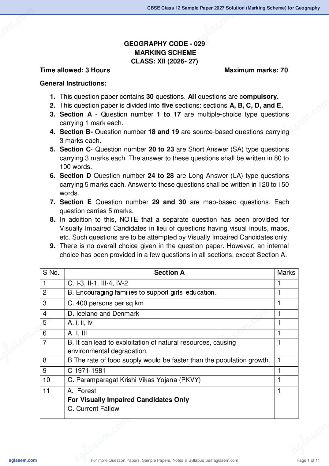
GEOGRAPHY CODE - 029
MARKING SCHEME
CLASS: XII (2026- 27)
Time allowed: 3 Hours Maximum marks: 70
General Instructions:
1. This question paper contains 30 questions. All questions are compulsory.
m
.co
2. This question paper is divided into five sections: sections A, B, C, D, and E.
m
.co
3. Section A - Question number 1 to 17 are multiple-choice type questions
e m
em
carrying 1 mark each.
l as
s
4. Section B- Question number 18 and 19 are source-based questions carrying
l a ag
g
3 marks each.
a
5. Section C- Question number 20 to 23 are Short Answer (SA) type questions
carrying 3 marks each. The answer to these questions shall be written in 80 to
100 words.
6. Section D Question number 24 to 28 are Long Answer (LA) type questions
carrying 5 marks each. Answer to these questions shall be written in 120 to 150
words.
7. Section E Question number 29 and 30 are map-based questions. Each
question carries 5 marks.
m
.co
8. In addition to this, NOTE that a separate question has been provided for
m
e
Visually Impaired Candidates in lieu of questions having visual inputs, maps,
s
la
etc. Such questions are to be attempted by Visually Impaired Candidates only.
ag
9. There is no overall choice given in the question paper. However, an internal
choice has been provided in a few questions in all sections, except Section A.
S No. Section A Marks
1 C. I-3, II-1, III-4, IV-2 1
2 B. Encouraging families to support girls’ education. 1
3 C. 400 persons per sq km 1
4 D. Iceland and Denmark
o m 11
m
c. o6
5 A. i, ii, iv
m.c
s e
em
A. I, III 1
s 7 B. It can lead to exploitation of natural resources, causing
g l a 1
l a a
ag
environmental degradation.
8 B The rate of food supply would be faster than the population growth. 1
9 C 1971-1981 1
10 C. Paramparagat Krishi Vikas Yojana (PKVY) 1
11 A. Forest 1
For Visually Impaired Candidates Only
C. Current Fallow
m .
.co s e m
s em l a
g la ag
a For more Question Papers, Sample Papers, Notes & Syllabus visit Page 1 of 11
Page 3
For Visually Impaired Candidates Only
C. Ganga Basin
13 A. Both (A) and (R) are correct and (R) is the correct explanation of A. 1
14 C. Implementing rainwater harvesting, recycling and reusing 1
wastewater.
15 B. 2 1
16 B. INSAT – Indian National Satellite System 1
17 B II,V 1
Section- B
Source Based Question
18 18.1 Suez Canal 1
18.2 This canal connects the Mediterranean Sea and the Red Sea. ½+½
=1
18.3 It gives Europe a new gateway to the Indian Ocean and reduces 1
direct sea-route distance between Liverpool and Colombo compared
to the Cape of Good Hope route. About 100 ships travel daily through
this canal.
For Visually Impaired Candidates Only
18.1 Answer: This canal connects the Atlantic Ocean in the east to the ½+½
Pacific Ocean in the west. =1
18.2 Answer: It has been constructed across the Panama Isthmus ½+½
between Panama City and Colon. =1
18.3 Answer: One major benefit of this canal:
The Panama Canal greatly reduces the distance and time of sea travel 1
between the Atlantic and Pacific oceans (Western Europe and the
West-coast of U.S.A; and North-eastern and Central U.S.A. and East
and South-east Asia), thereby facilitating faster and cheaper
international trade.
19 I. The term population distribution refers to the way people are 1
spaced over the earth’s surface.
II. Physical Factor ½+½
Climate/ Terrain/ Availability of water (Any one)
Economic factor:
Development of irrigation/Availability of mineral and energy resources/
Development of transport network (Any one)
For more Question Papers, Sample Papers, Notes & Syllabus visit Page 2 of 11
Page 4
m .co
m .co s e m
se g l a
III. Densely populated a ½+½
North Indian Plains/deltas / Coastal Plains (Any one) =1
Sparsely Populated
Southern and central Indian States/Himalayas/some of the
north eastern states. (Any one)
Section C
20 The concept of human development was introduced by Dr Mahbub-ul- 3
m
.co
Haq. Dr Haq has described human development as development that
m
.co
enlarges people’s choices and improves their lives. People are central
e m
e m
to all development under this concept. The basic goal of development
l as
s
is to create conditions where people can live meaningful lives.
l a ag
ag Leading a long and healthy life, being able to gain knowledge and
having enough means to be able to live a decent life are the most
important aspects of human development. Therefore, access to
resources, health and education are the key areas in human
development.
21 I. The British and other Europeans have developed a number of 3
towns in India. Starting their foothold on coastal locations. They
first developed some trading ports such as Surat, Daman, Goa,
Pondicherry, etc.
m
II.
.co
The British later consolidated their hold around three principal
m
e
nodes – Mumbai (Bombay), Chennai (Madras), and Kolkata
s
la
(Calcutta) and built them in the British style. Rapidly extending
g
a
their domination either directly or through control over the
princely states, they established their administrative centres, hill
towns as summer resorts, and added new civil, administrative
and military areas to them.
III. Towns based on modern industries also evolved after 1850.
Jamshedpur can be cited as an example.
IV. After independence, a large number of towns have been
developed as administrative headquarters, e.g., Chandigarh,
m
.co
Bhubaneswar, Gandhinagar, Dispur, etc., and industrial
m
.co m
centres, such as Durgapur, Bhilai, Sindri, Barauni.
m s e
a
V. Some old towns also developed as satellite towns around
s e g l
la
metropolitan cities, such as Ghaziabad, Rohtak, Gurugram
g around Delhi. With increasing investment in rural areas, a largea
a number of medium and small towns have developed all over the
country.
Any Three points.
22 Neodeterminism, also known as “stop-and-go determinism,” was 1+2
introduced by Griffith Taylor. It states that nature sets certain limits for
human activities, but within these limits, humans have the freedom to
choose and develop according to their needs and capabilities.
m .
.co s e m
s em l a
g la ag
a For more Question Papers, Sample Papers, Notes & Syllabus visit Page 3 of 11
Page 5
Possibilism as:
i. This concept shows that neither is there a situation of absolute
necessity (environmental determinism) nor is there a condition
of absolute freedom (possibilism). It means that human beings
can conquer nature by obeying it.
ii. They have to respond to the red signals and can proceed in
their pursuits of development when nature permits
modifications. It means that possibilities can be created within
the limits which do not damage the environment and there is no
free run without accidents.
iii. The free run which the developed economies attempted to take
has already resulted in the greenhouse effect, ozone layer
depletion, global warming, receding glaciers and degrading
lands. Any two points
iv. Neo determinism promotes sustainable development, where
human progress takes place in harmony with nature, avoiding
overexploitation.
Any two points
23(A) The company should choose KPO (Knowledge Process Outsourcing). 1
KPO involves outsourcing highly skilled, knowledge-intensive work 2
such as research and development (R&D), legal services, business
analysis, consultancy, and data analytics. These tasks require
specialized expertise, advanced analytical skills, and professional
knowledge. In contrast, BPO (Business Process Outsourcing) deals
mainly with routine, repetitive, and process-based tasks like customer
support, data entry, and payroll processing.
Therefore, for work that demands expert knowledge and research,
KPO is the appropriate choice.
OR
23(B) Digital Divide refers to the gap between individuals, regions, or 1
countries in terms of access to digital technologies, such as the
internet, computers, and digital skills.
Example:
2
i. Between countries, developed nations like the USA and Japan
have widespread access to high-speed internet and advanced
digital infrastructure, while many developing countries still lack
reliable internet connectivity.
For more Question Papers, Sample Papers, Notes & Syllabus visit Page 4 of 11
Page 6
m .co
m .co s em
se g la
ii. a have better access to
Within a country like India, urban areas
the internet and digital services, whereas many rural areas
have limited connectivity and digital literacy. This divide affects
education, employment opportunities, and access to
information, increasing social and economic inequalities.
Section D
m
24(A) i. Agro based-Sugar, Tea, Coffee, 1X5=
m .co
ii. Mineral based 5
.co e m
a. Metallic: Iron and steel, Copper
e m
b. Non Metallic: Cement
l as
l as
iii. Forest based-Timber, Paper
ag
ag iv. Chemical Based: Petrochemical, Fertilizer
v. Animal Based: Leather, Wood
(Explain each point.)
OR 1X5=
24(B) i. Access to Market 5
ii. Access to Raw Material
iii. Access to Labour Supply
m
.co
iv. Access to Sources of Energy
v. Access to Transportation and Communication Facilities
e m
vi. Government Policy
las
g
vii. Access to Agglomeration Economies/ Links between Industries
(Explain any five points)
a
25(A) The seaports are known as ‘the gateway of international trade’. 2+3=
5
I. The ports as suction points of the resources from their
hinterlands. The extension of railways towards the interior
facilitated the linking of the local markets to regional markets,
m
.co
regional markets to national markets and national markets to
m
.co m
the international.
m II. The ports are handling large volumes of domestic, as well as,
s e
s e overseas trade. Most of the ports are equipped with modern
g l a
g la infrastructure. a
a III. Ocean transport is the cheapest mode of transport for bulky and
heavy goods over long distances and approximately 95% of
international trade by volume is carried out through ocean
routes.
IV. Ports are not just docking points; they are complex service
centers that facilitate trade through providing facilities for
docking, loading, unloading, and storage (warehousing) of
m .
.co s e m
s em l a
g la ag
a For more Question Papers, Sample Papers, Notes & Syllabus visit Page 5 of 11
Page 7
barges, and labor to ensure ships can enter and exit safely.
Any two Points
Importance of Kandla Port
I. Deendayal Port (Kandla port) situated at the head of Gulf of
Kuchchh. It has been developed as a major port to cater to the
needs of western and north western parts of the country
II. This is to reduce the pressure at Mumbai port.
III. The port is specially designed to receive large quantities of
petroleum and petroleum products and fertiliser.
IV. The offshore terminal at Vadinar has been developed to reduce
the pressure at the port.
Any three points
OR
25(B) The composition of commodities in India’s international trade 1x5=
has been undergoing a change over the years. 5
I. In export the share of agriculture and allied products and
manufactured goods have decreased.
II. Share from crude petroleum and products and other
commodities have increased.
III. The decline in traditional items is largely due to the tough
international competition.
IV. Amongst the agriculture products, there is a decline in the
export of traditional item, such as cashew, etc., though an
increase has been registered in floricultural products, fresh
fruits, marine products and sugar, etc.
V. Engineering goods have shown a significant growth in exports.
VI. During 1950s and 1960s the major item of import at that time
was foodgrain, capital goods, machinery and equipment. After
1970s, foodgrain import was discontinued due to the success
of Green Revolution.
VII. Foodgrain import was replaced by fertilisers and petroleum.
Machines and equipment, special steel, edible oil and
chemicals largely make the import basket.
Any five points (Include at least two of import and two of export)
For more Question Papers, Sample Papers, Notes & Syllabus visit Page 6 of 11
Page 8
m .co
m .co s em
se g la
a
26(A) The urban wastes should be treated as resources and utilized for 5
generating renewable energy and compost.
I. Untreated wastes ferment slowly and release toxic biogas to the
atmosphere, including methane which can be harnessed to
produce biogas. Rapid urbanisation has increased the volume
of waste, but scientific management can convert it into useful
products.
m
.co
II. Segregation of waste at source into biodegradable, non-
m
.co m
biodegradable and hazardous waste is the first essential
m
step.Biodegradable waste from households and markets can
s e
s e l a
ag
be converted into high-quality organic manure.
g l a
III. Recycling of paper, plastic, glass and metals conserves raw
a materials, saves energy and reduces environmental pollution.
Organic waste from households and markets can be converted
into compost or vermicompost, which can be used in urban
forestry and agriculture to improve soil fertility.and reduces
dependence on chemical fertilisers.
IV. Waste-to-energy technologies, such as biogas plants and
incineration, help generate electricity and reduce landfill
m
pressure. Treated wastewater can be reused for irrigation,
.co
gardening and industrial purposes, conserving freshwater
m
resources.
s e
la
V. Scientific landfills and methane recovery prevent soil and
ag
groundwater contamination. Public awareness, community
participation and effective municipal governance are essential
for sustainable waste management. Thus, proper treatment of
urban waste supports a circular economy and sustainable
development.
OR
26(B) I. Noise pollution refers to the state of unbearable and 5
uncomfortable noise to human beings, which is caused from
m
.co
different sources. This matter has become a serious
m
.co m
concern only in recent years due to a variety of technological
m innovations.
s e
s e II. The main sources of noise pollution are various factories,
g l a
g la mechanised construction and demolition a
works,
a automobiles, and aircraft, etc.
III. There may be added polluting noise from sirens,
loudspeakers used in various festivals, programmes
associated with community activities.
IV. The biggest nuisance is the noise produced by traffic. Its
intensity and nature depend upon factors, such as the type
m .
.co s e m
s em l a
g la ag
a For more Question Papers, Sample Papers, Notes & Syllabus visit Page 7 of 11
Page 9
well as that of the vehicle (in case of automobiles).
V. In sea traffic, the noise pollution is confined to the harbour
due to loading and unloading activities being carried.
Industries cause noise pollution, but with varying intensity
depending upon the type of industry. Noise pollution is
location specific and its intensity declines with increase in
distance.
27 Any five differences. 2½+2
½=5
Intensive Subsistence Extensive Commercial
Farming Grain Farming
I Intensive Subsistence Commercial grain cultivation is
Agriculture is largely found practised in the interior parts of
in densely populated semi-arid lands of the mid
regions of monsoon Asia. latitudes.
II Basically, there are two Wheat is the principal crop,
types of intensive though other crops like corn,
subsistence agriculture. (i) barley, oats and rye are also
Intensive subsistence grown.
agriculture dominated by
wet paddy cultivation which
is characterised by
dominance of the rice
crop. (ii) Intensive
subsistence agriculture
dominated by crops other
than paddy.
III Land holdings are very The size of the farm is very
small due to the high large.
density of population.
IV Farmers work with the help The entire process of
of family labour leading to cultivation, ranging from
intensive use of land. Use ploughing to harvesting, is
of machinery is limited and mechanized.
most of the agricultural
operations are done by
manual labour.
V Farm yard manure is used Fertility of the soil is
to maintain the fertility of maintained by applying
the soil. fertilizers.
For more Question Papers, Sample Papers, Notes & Syllabus visit Page 8 of 11
Page 10
m .co
m .co s em
se g la
VI In this type a of agriculture, there
of In this type
agriculture,the yield per unit is a low yield per acre but a
area is high but per labour high yield per person.
productivity is low.
VII Due to variations in relief, This type of agriculture is best
climate and soil, paddy is developed in Eurasian
not grown everywhere in steppes, the Canadian and
m
.co
monsoon Asia. Wheat, American Prairies, the
m
.co m
soybean, barley and Pampas of Argentina, the
m
sorghum are cultivated in Velds of South Africa, the
s e
s e l a
ag
northern China, Manchuria, Australian Downs, and the
g l a North Korea and northern Canterbury Plains of New
a Japan. In India, wheat is Zealand.
grown in the western Indo-
Gangetic Plains, while
millets are grown in the dry
regions of western and
southern India.
m
28(A)
.co
The role of the Indira Gandhi Canal in bringing about changes in the 5
em
ecology, economy, and society of the Thar Desert region is as follows
s
g a Indira Gandhi Canal has increased
lThe
soil moisture anda vegetation cover in the arid Thar Desert,
1. Ecological Impact:
reducing desert conditions, though it has also led to problems
of waterlogging and salinity in some areas.
2. Agricultural Development: The canal has provided assured
irrigation, expanding the cultivated area and enabling the
cultivation of crops such as wheat, cotton and mustard instead
of traditional dry farming.
m
.co
3. Change in Cropping Pattern: There has been a shift from
m
.co m
subsistence crops like bajra to water-intensive and commercial
m
crops due to the availability of canal water.
s e
s e 4. Economic Transformation: Increased agricultural productivity
g l a
g la has improved farm incomes, generated employment, and a
a encouraged the growth of agro-based industries in the region.
5. Social Change: The canal has promoted settlement, reduced
out-migration, and improved living standards by supporting
better infrastructure and socio-economic development.
OR
The Bharmour tribal region of Chamba district lies in the trans-
m
Himalayan physiographic zone and is drained mainly by the Ravi River
.
.co s e m
s em l a
g la ag
a For more Question Papers, Sample Papers, Notes & Syllabus visit Page 9 of 11
Page 11
accessibility, and fragile ecosystem, special measures are required to
ensure sustainable development and improve the quality of life of tribal
communities.
1. Development of Infrastructure and Connectivity: Improve road
connectivity between valleys and settlements while ensuring
minimal ecological damage.
2. Sustainable Use of Natural Resources: Promote controlled
grazing to prevent degradation of alpine pastures. Encourage
afforestation and social forestry on slopes to prevent soil erosion
and landslides.
3. Agriculture and Livelihood Support: Promote terrace farming
and cultivation of high-altitude crops suitable to local conditions.
Encourage horticulture, medicinal herbs, and traditional crafts to
diversify income sources.
4. Water Resource Management: Ensure sustainable use of river
water through small irrigation channels. Develop hydel projects on
tributaries of the Ravi River to meet local energy needs without
harming the environment.
5. Education, Health, and Social Development: Improve access to
education and healthcare facilities in remote areas. Promote tribal
welfare programmes, skill development, and preservation of tribal
culture.
(Any five points)
Section E
29 A- Northern part of Eurasia 1X5
B- Vancouver
C- Kolkata
D- Jeddah
E- Darwin
F- Panama Canal
G- St. Lawrence waterway
For Visually Impaired Candidates only
29 A- Arabian peninsula /Mongolia/Central China
29 B- Vancouver
29 C- Kolkata
29 D- Johannesburg
29 E- Darwin
29 F- Suez Canal
29 G- St. Lawrence waterway
For more Question Papers, Sample Papers, Notes & Syllabus visit Page 10 of 11
Page 12
m .co
m .co s em
se g la
30 a
Locate and label any five of the following geographical features on the 1x5
Political Outline map of India with appropriate symbols:
A. Arunachal Pradesh
B. Paradwip
C. Neyveli
D. Bailadila iron-ore mines, Chattisgarh
E. Jamnagar
m
.co
F. Uttar Pradesh
m
.co m
G. Thiruvananthapuram
m s e
s e l a
ag
For visually impaired students
g l a
Attempt any five.
a
A. Arunachal Pradesh
B. Paradwip
C. Neyveli
D. Chhatisgarh
E. Jamnagar
F. Uttar Pradesh
G. Thiruvananthapuram
m
m .co
s e
g la
a
m
m .co
m .co s e m
s e g l a
g la a
a
m .
.co s e m
s em l a
g la ag
a For more Question Papers, Sample Papers, Notes & Syllabus visit Page 11 of 11
Document Details
| Board / Org | CBSE |
| Exam | Class 12 |
| Type | Solution |
| Pages | 11 |
| Updated | 29 Oct 2026 |