MAHA SET 2018 Question Paper 2 Geography
Finished viewing? Save it for later —
Download MAHA SET 2018 Question Paper 2 Geography (PDF · 24 pages)About MAHA SET 2018 Question Paper 2 Geography
MAHA SET 2018 Question Paper 2 Geography is available here for free download. Published by Maharashtra Exams for Maharashtra State Eligibility Test, this question paper can be viewed online or downloaded as a PDF (24 pages). Candidates preparing for Maharashtra State Eligibility Test can use MAHA SET 2018 Question Paper 2 Geography to understand the exam pattern, the type of questions asked, and the overall difficulty level.
Frequently Asked Questions
How can I download MAHA SET 2018 Question Paper 2 Geography?
Open this page and click the Download button to save MAHA SET 2018 Question Paper 2 Geography as a PDF. It is completely free on AglaSem Docs.
Is MAHA SET 2018 Question Paper 2 Geography free to download?
Yes. MAHA SET 2018 Question Paper 2 Geography can be viewed online and downloaded as a PDF free of cost on AglaSem Docs.
How many pages does MAHA SET 2018 Question Paper 2 Geography have?
MAHA SET 2018 Question Paper 2 Geography contains 24 pages, which you can read online or download together as a single PDF.
Where can I find more Maharashtra State Eligibility Test study material?
You can find more Maharashtra State Eligibility Test question papers, sample papers, syllabus, and answer keys on AglaSem Docs.
MAHA SET 2018 Question Paper 2 Geography – Text
Read the full text of this question paper below — useful to quickly search, copy and reference the content online without downloading the PDF.
📄 View text version (24 pages)
Page 1
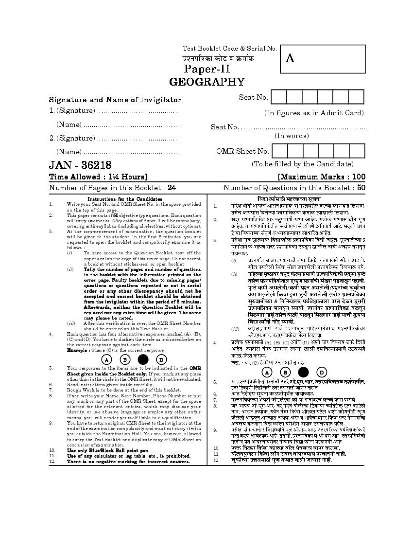
A
GEOGRAPHY
Signature and Name of Invigilator Seat No.
1. (Signature) ......................................... (In figures as in Admit Card)
(Name) ................................................ Seat No. ..............................................................
2. (Signature) ......................................... (In words)
(Name) ................................................ OMR Sheet No.
JAN - 36218 (To be filled by the Candidate)
Time Allowed : 1¼ Hours] [Maximum Marks : 100
Number of Pages in this Booklet : 24 Number of Questions in this Booklet : 50
Instructions for the Candidates
1. Write your Seat No. and OMR Sheet No. in the space provided 1.
on the top of this page.
2. This paper consists of 50 objective type questions. Each question
will carry two marks. All questions of Paper-II will be compulsory, 2.
covering entire syllabus (including all electives, without options).
3. At the commencement of examination, the question booklet
will be given to the student. In the first 5 minutes, you are
requested to open the booklet and compulsorily examine it as 3.
follows :
(i) To have access to the Question Booklet, tear off the
paper seal on the edge of this cover page. Do not accept (i)
a booklet without sticker-seal or open booklet.
(ii) Tally the number of pages and number of questions
in the booklet with the information printed on the (ii)
cover page. Faulty booklets due to missing pages/
questions or questions repeated or not in serial
o rder or any other discre pancy should not be
accepted and correct booklet should be obtained
from the invigilator within the period of 5 minutes.
Afterwards, neither the Question Booklet will be
replaced nor any extra time will be given. The same
may please be noted.
(iii) After this verification is over, the OMR Sheet Number
should be entered on this Test Booklet. (iii)
4. Each question has four alternative responses marked (A), (B),
(C) and (D). You have to darken the circle as indicated below on
the correct response against each item. 4. (A), (B), (C) (D)
Example : where (C) is the correct response.
A B D
(C)
5. Your responses to the items are to be indicated in the OMR
Sheet given inside the Booklet only. If you mark at any place A B D
other than in the circle in the OMR Sheet, it will not be evaluated.
5.
6. Read instructions given inside carefully.
7. Rough Work is to be done at the end of this booklet.
8. If you write your Name, Seat Number, Phone Number or put 6.
any mark on any part of the OMR Sheet, except for the space 7.
allotted for the relevant entries, which may disclose your 8.
identity, or use abusive language or employ any other unfair
means, you will render yourself liable to disqualification.
9. You have to return original OMR Sheet to the invigilator at the
end of the examination compulsorily and must not carry it with 9.
you outside the Examination Hall. You are, however, allowed
to carry the Test Booklet and duplicate copy of OMR Sheet on
conclusion of examination.
10. Use only Blue/Black Ball point pen. 10.
11. Use of any calculator or log table, etc., is prohibited. 11.
12. There is no negative marking for incorrect answers. 12.
Page 2
Page 3
Paper II
II
Time Allowed : 75 Minutes] [Maximum Marks : 100
Note : This paper contains Fifty (50) multiple choice questions, each carrying
Two (2) marks. Attempt All questions.
(50) (2)
1. Assertion (A) : 1. (A)
The continent of Africa does not
have long and lofty fold mountain
system.
Reason (R) : (R)
Plate boundaries around the
continent of Africa are mostly
(Divergent)
divergent in nature.
Which one of the following is
correct ?
(A) Both (A) and (R) are true and
(A) (A) (R) (R)
(R) is the correct explanation
of (A) (A)
(B) Both (A) and (R) are true and (B) (A) (R)
(R) is not the correct explanation
(R) (A)
of (A)
(C) (A) (R)
(C) (A) is true but (R) is false
(D) (A) is false but (R) is true (D) (A) (R)
3 [P.T.O.
Page 4
(A) Erosion of a platform by
(A)
moving sediment
(B) Reduction of size of a particle (B)
in transit
(C)
(C) Disintegration of a rock
(D)
(D) A core stone as a product of
chemical weathering
3. The term “bergschrund” is 3.
associated with ..........................
processes.
(A)
(A) Coastal
(B)
(B) Aeolian
(C)
(C) Fluvial
(D) Glacial (D)
4. Which of the following scientists is 4.
also credited for the concept of
isostasy ?
(A)
(A) McGee
(B)
(B) Karl Gilbert
(C)
(C) Dutton
(D) Maj. Powell (D)
4
Page 5
5.
waves occurs on the surface of the
earth because :
(A) All the earthquake waves get (A)
absorbed in this zone
(B) All the earthquake waves are
absorbed by the mantle (B)
(C) P waves are refracted and S
(C) ‘P’ ‘S’
waves are absorbed by the
mantle
(D) S waves are refracted and P
(D) ‘S’ ‘P’
waves are absorbed by the
mantle
6. Relative humidity increase when : 6.
(A) The temperature decreases (A)
(B) The temperature increases (B)
(C) Wind velocity decreases (C)
(D) Wind velocity increases (D)
5 [P.T.O.
Page 6
climate change is referred to
as ..................... .
(A)
(A) Radiative forcing
(B)
(B) Greenhouse effect
(C)
(C) Ozone depletion
(D)
(D) Melting of snow
8. The equatorial regions receive very 8.
high amount of rainfall because
of :
(1)
(1) Nearness to storm tracks
(2)
(2) Closeness to warm water
(3) Year round instability of (3)
atmosphere (4) CT
(4) Inversion of CT airmasses
(A) (1), (2) (4)
(A) (1), (2) and (4)
(B) (2), (3) (4)
(B) (2), (3) and (4)
(C) (1), (2) (3)
(C) (1), (2) and (3)
(D) (1), (3) and (4) (D) (1), (3) (4)
6
Page 7
for the summer monsoon over
northern hemisphere as a system
of winds ?
(A)
(A) A system, marked with seasonal
wind shift, caused by differential
heating of the land and the sea.
(B) Winds that are largely confined
(B) 20°
to the tropics i.e. the region up
to 20°N.
(C) Summer monsoon winds are (C)
the resultant deflections of
southeast trades due to earth’s
rotation.
(D) Summer monsoon approach the
(D)
land from northeasterly
direction.
10. The layers between the tropopause 10.
and the lower thermosphere are
commonly referred to as .................
atmosphere.
(A)
(A) Middle
(B) Lower (B)
(C) Upper (C)
(D) Topper (D)
7 [P.T.O.
Page 8
as a passive soil forming factors ?
(A) Parent rock (A)
(B) Climate (B)
(C) Time (C)
(D) Biota (D)
12. Photic zone means : 12.
(A) The layer of ocean where all (A)
biological life is located.
(B) The zone where only coral reefs
(B)
are located.
(C)
(C) The layer of ocean upto which
sufficient light penetrates
(D) The layer in which photo- (D)
synthesis is not possible
13. Which is the important driving force 13.
for ocean current movement ?
(A) Ocean surface water density
(A)
(B) Ocean water temperature
(B)
change
(C)
(C) Prevailing winds
(D) Salinity (D)
8
Page 9
to mid latitudes because of :
(A) High rainfall
(A)
(B) Hot and humid climatic
(B)
conditions
(C) Suitable temperature conditions (C)
(D) Suitable salinity conditions (D)
15. Which one of the following is 15.
referred to as the producer in marine
ecosystem ?
(A)
(A) Phytoplankton
(B)
(B) Zooplankton
(C)
(C) Fungi
(D) Small fish (D)
16. The Orthographic and Stereographic 16.
projections were designed by :
(A) Thales (A)
(B) Eratosthenes (B)
(C) Hipparchus (C)
(D) Aneximander (D)
9 [P.T.O.
Page 10
along a particular road, but it offers
a number of opportunities from
among which man is free to select”
is related to :
(A) Determinism (A)
(B) Neo-determinism (B)
(C) Possibilism (C)
(D) Stop and Go Determinism (D)
18. The landscapes reflects two primal 18.
needs of man “Prospect and Refuge”
was advocated by :
(A) Appleton (A)
(B) Samuels (B)
(C) Johnston (C)
(D) Ralph (D)
10
Page 11
select the correct answer from the
codes given below :
-I -II
List-I List-II
(a) (1)
(a) Homer (1) Outline of
Geography
(b) Hecataeus (2) Historical (b) (2)
Memoir (c) (3)
(c) Strabo (3) Illiod and
Odyssey
(d) (4)
(d) Ptolemy (4) Ges-Periodos
Codes :
(a) (b) (c) (d)
(a) (b) (c) (d)
(A) (3) (2) (4) (1)
(A) (3) (2) (4) (1)
(B) (2) (1) (3) (4)
(B) (2) (1) (3) (4)
(C) (3) (4) (2) (1) (C) (3) (4) (2) (1)
(D) (3) (2) (1) (4) (D) (3) (2) (1) (4)
20. Who has divided the Cosmography 20.
into Uranography and Geography ?
(A) Hettner
(A)
(B) Blache
(B)
(C) Humboldt (C)
(D) Davis (D)
11 [P.T.O.
Page 12
population of the largest city is 15,00,000
15,00,000, then the population of the
fourth largest city would be :
(A) 3,00,000 (A) 3,00,000
(B) 3,75,000 (B) 3,75,000
(C) 5,00,000 (C) 5,00,000
(D) 7,50,000 (D) 7,50,000
22. Who is associated with the 22.
statements given below :
(i) Migration occurs in small steps (i)
(ii) Most migrants go to short (ii)
distance
(iii) Long distance migrants go to (iii)
urban areas.
(A) Tadora (A)
(B) Everett Lee (B)
(C) Zelinsky (C)
(D) Revenstein (D)
12
Page 13
resides in ............................ latitude.
(A) 20—40°N (A) 20—40°N
(B) 20—40°S (B) 20—40°S
(C) 40—60°N (C) 40—60°N
(D) 30—60°S (D) 30—60°S
24. In the context of population, which 24.
of the following statements is not
correct ?
(A)
(A) Europe is ‘Aged Population’
Continent
(B)
(B) China is the most populous
country in the world
(C)
(C) India and China support 50%
50%
of the world’s population
(D) Africa has the world’s highest (D)
fertility rate
13 [P.T.O.
Page 14
at right angle by series of secondary
roads, parallel to one another would
develop ............................... type of
rural settlement pattern.
(A) Grid (A)
(B) Crucified (B)
(C) Herring bone (C)
(D) Angular (D)
26. In the south eastern USA 26.
‘Specialised horticulture and
olericulture’ is called ................... .
(A) Conuco (A)
(B) Truck farming (B)
(C) Chiltenene (C)
(D) Tavy (D)
14
Page 15
correctly matched ?
(A)
(A) Milpa — Central America
(B)
(B) Caingin — Philippines
(C)
(C) Podu — India
(D) Berbecho — Thailand (D)
28. When production increased in 28.
comparison to the quantity of cost
elements is called :
(A)
(A) Constant return to scale
(B)
(B) Economies of the scale
(C)
(C) Diseconomies of the scale
(D) Average cost curve (D)
29. Which of the following pairs is 29.
incorrect ?
Resources T y pes
(A) :
(A) Forest : National
resource
(B) :
(B) Tides : Inexhaustible
(C) Coal : Inorganic (C) :
(D) Wild animal : Renewable (D) :
15 [P.T.O.
Page 16
dimension of Human Development
Index (HDI) ?
(A)
(A) Longevity
(B)
(B) Knowledge
(C) Decent Standard of Living (C)
(D) Equality (D)
31. Gentrification is a settlement of : 31.
(A) High class
(A)
(B) Middle class
(B)
(C) Low class (C)
(D) Ethnic community (D)
32. What does ‘Fourth World’ refer to ? 32.
(A) Poorest and vulnerable groups (A)
of people within the developing
world
(B) Poorest and vulnerable groups (B)
of people within the developed
world
(C)
(C) Poorest and vulnerable groups
of people in the world
(D)
(D) Richest and affluent groups of
people in the world
16
Page 17
refers to :
(A)
(A) Occupied lands
(B)
(B) Extra-terrestrial lands
(C)
(C) Resettled lands
(D) Empty lands (D)
34. What does the ‘index of dissimilarity’ 34.
measure ?
(A)
(A) Racial discrimination
(B)
(B) Residential segregation
(C)
(C) Gender gap
(D) Caste difference (D)
35. Which book is considered as a key 35.
text of political geography ?
(A) Politische Geographie (A)
(B) Liberalism (B)
(C) Democratic Ideals and Reality (C)
(D) Geopolitics of the World System (D)
17 [P.T.O.
Page 18
must have ........................ population
to be identified as urban places.
(A) 50000 (A) 50000
(B) 500000 (B) 500000
(C) 5000 (C) 5000
(D) 10000 (D) 10000
37. Economic growth done by ............... 37.
sector is called as imperative
planning.
(A) Public (A)
(B) Private (B)
(C) Joint (C)
(D) External agencies (D)
38. Which one of the following states of 38.
India has the highest rank in the
Human Development Index ?
(A) Tamil Nadu (A)
(B) Kerala (B)
(C) Punjab (C)
(D) Haryana (D)
18
Page 19
have ........................ characteristics.
(A) Homogenous and functional (A)
(B) Heterogenous and formal (B)
(C) Homogenous and formal (C)
(D) Heterogenous and functional (D)
40. ‘Poddlers’ in Netherland are classic 40.
examples of landuse planning based
on model of ....................... .
(A) Christaller (A)
(B) Von Thunen (B)
(C)
(C) E. Burgees
(D)
(D) Weber
41. The Aravalli range run across 41.
which of the following Indian
states ?
(A) Gujarat, Rajasthan, Punjab and
Delhi (A)
(B) Punjab, Rajasthan, Haryana
and Delhi (B)
(C) Gujarat, Rajasthan, Haryana
and Delhi (C)
(D) Gujarat, Rajasthan, U.P. and
(D)
Delhi
19 [P.T.O.
Page 20
at the southern end of the Nilgiri
hills in South India ?
(A)
(A) The Thalgat Pass
(B)
(B) The Bhorghat Pass
(C) The Bolan Pass (C)
(D) The Palghat Gap (D)
43. As per 2011 census the most densely 43. 2011
populated state of India is .......... .
(A) West Bengal (A)
(B) Kerala (B)
(C) Uttar Pradesh (C)
(D) Bihar (D)
44. Which of the following is not 44.
transport region ?
(A)
(A) Konkan Railway
(B)
(B) Central Railway
(C)
(C) Western Railway
(D)
(D) Himalayan Railway
20
Page 21
refineries are set up by :
(A) Indian Oil Corporation Ltd.
(B) Bharat Petroleum Corporation
(A)
Ltd.
(B)
(C) Crude Distillation Unit of
(C)
Madras Refineries Ltd.
(D) Hindustan Petroleum Corpo-
ration Ltd. (D)
46. If the minimum mapping unit is one 46.
acre and if this is to occupy one
square cm area on the map. What
should be the scale of map ?
(A) 1 : 5,000 (A) 1 : 5,000
(B) 1 : 5,500 (B) 1 : 5,500
(C) 1 : 6,000 (C) 1 : 6,000
(D) 1 : 6,360 (D) 1 : 6,360
21 [P.T.O.
Page 22
shades that can be generated on
computer monitor if the satellite
data of any three bands with
quantization level is 28 ?
(A) 16777216
(A) 16777216
(B) 1677216
(B) 1677216
(C) 1677816
(C) 1677816
(D) 72167716 (D) 72167716
48. In FCC, vegetation is seen in red 48.
colour because ....................... .
(A)
(A) Vegetation reflects near
infrared
(B)
(B) Vegetation reflects green
(C)
(C) Near infrared is represented
as red
(D)
(D) Red is represented as green
22
Page 23
highest frequency in visible
spectrum range ?
(A)
(A) Blue
(B)
(B) Green
(C)
(C) Yellow
(D)
(D) Red
50. Arithmetic mean is considered to be 50.
the most balanced measure of central
tendency because :
(A)
(A) It lies at the centre of the range
(B)
(B) All the observation values
participate in its determination
(C)
(C) It is free from the influence of
extreme value
(D) Sum of deviations from it equals (D)
zero
23 [P.T.O.
Page 24
24
Document Details
| Board / Org | Maharashtra Exams |
| Exam | Maharashtra State Eligibility Test |
| Type | Question Paper |
| Pages | 24 |
| Updated | 30 Apr 2026 |