PU CET PG 2018 Question Paper Masters in Remote Sensing _ GIS
Finished viewing? Save it for later —
Download PU CET PG 2018 Question Paper Masters in Remote Sensing _ GIS (PDF · 6 pages)About PU CET PG 2018 Question Paper Masters in Remote Sensing _ GIS
PU CET PG 2018 Question Paper Masters in Remote Sensing _ GIS is available here for free download. Published by Punjab University for PU CET PG, this question paper can be viewed online or downloaded as a PDF (6 pages). Candidates preparing for PU CET PG can use PU CET PG 2018 Question Paper Masters in Remote Sensing _ GIS to understand the exam pattern, the type of questions asked, and the overall difficulty level.
Frequently Asked Questions
How can I download PU CET PG 2018 Question Paper Masters in Remote Sensing _ GIS?
Open this page and click the Download button to save PU CET PG 2018 Question Paper Masters in Remote Sensing _ GIS as a PDF. It is completely free on AglaSem Docs.
Is PU CET PG 2018 Question Paper Masters in Remote Sensing _ GIS free to download?
Yes. PU CET PG 2018 Question Paper Masters in Remote Sensing _ GIS can be viewed online and downloaded as a PDF free of cost on AglaSem Docs.
How many pages does PU CET PG 2018 Question Paper Masters in Remote Sensing _ GIS have?
PU CET PG 2018 Question Paper Masters in Remote Sensing _ GIS contains 6 pages, which you can read online or download together as a single PDF.
Where can I find more PU CET PG study material?
You can find more PU CET PG question papers, sample papers, syllabus, and answer keys on AglaSem Docs.
PU CET PG 2018 Question Paper Masters in Remote Sensing _ GIS – Text
Read the full text of this question paper below — useful to quickly search, copy and reference the content online without downloading the PDF.
📄 View text version (6 pages)
Page 1
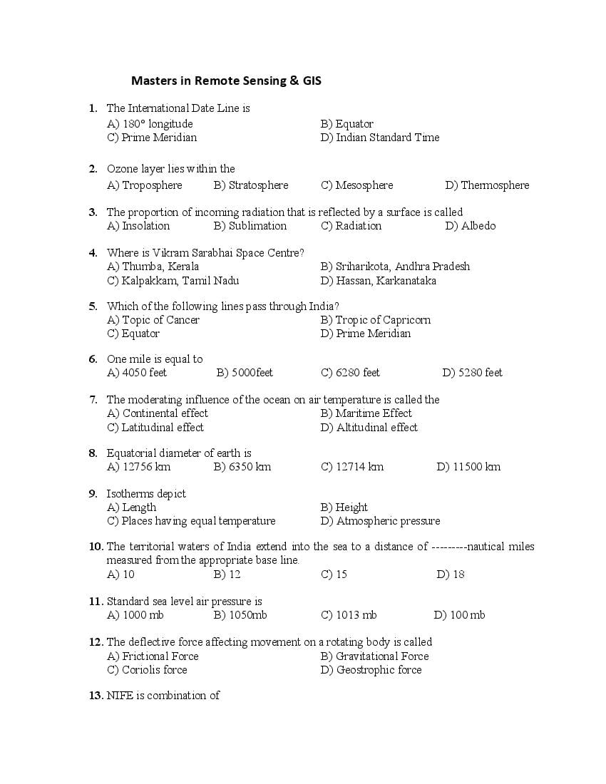
1. The International Date Line is
A) 180° longitude B) Equator
C) Prime Meridian D) Indian Standard Time
2. Ozone layer lies within the
A) Troposphere B) Stratosphere C) Mesosphere D) Thermosphere
3. The proportion of incoming radiation that is reflected by a surface is called
A) Insolation B) Sublimation C) Radiation D) Albedo
4. Where is Vikram Sarabhai Space Centre?
A) Thumba, Kerala B) Sriharikota, Andhra Pradesh
C) Kalpakkam, Tamil Nadu D) Hassan, Karkanataka
5. Which of the following lines pass through India?
A) Topic of Cancer B) Tropic of Capricorn
C) Equator D) Prime Meridian
6. One mile is equal to
A) 4050 feet B) 5000feet C) 6280 feet D) 5280 feet
7. The moderating influence of the ocean on air temperature is called the
A) Continental effect B) Maritime Effect
C) Latitudinal effect D) Altitudinal effect
8. Equatorial diameter of earth is
A) 12756 km B) 6350 km C) 12714 km D) 11500 km
9. Isotherms depict
A) Length B) Height
C) Places having equal temperature D) Atmospheric pressure
10. The territorial waters of India extend into the sea to a distance of ---------nautical miles
measured from the appropriate base line.
A) 10 B) 12 C) 15 D) 18
11. Standard sea level air pressure is
A) 1000 mb B) 1050mb C) 1013 mb D) 100 mb
12. The deflective force affecting movement on a rotating body is called
A) Frictional Force B) Gravitational Force
C) Coriolis force D) Geostrophic force
13. NIFE is combination of
Page 2
C) Neon and Fluorine D) Nitrate and Iron
14. Inter- Tropical Convergence Zone is
A) Low Pressure Zone B) High Pressure Zone
C) Calm Zone D) Volatile Zone
15. Which of the following is an example of Lagoon Lake?
A) Wular B) Superior C) Chilika D) Victoria lake
16. Representative Fraction (RF) on a map denotes
A) Divisions on Map B) Map Scale
C) Symbols on Map D) Colour scheme on map
17. Jet Streams is a name of
A) River in USA B) High altitude air
C) Ocean current D) Name of a plane
18. What percent of the face of the earth is covered by ocean?
A) 71 B) 75 C) 80 D) 66
19. The longest day in the Northern Hemisphere is on
A) March 21 B) September 23 C) Dec 22 D) June 21
20. Which of the following states has the longest coast line?
A) Maharashtra B) Wes Bengal C) Gujarat D) Tamil Nadu
21. Which one of the following describes the lithosphere?
A) Upper and lower mantle B) Crust and core
C) Crust and upper mantle D) Mantle and core
22. Retreating Monsoon brings heavy rainfall in
A) Punjab B) Gujarat C) Assam D) Tamil Nadu
23. Which of the following is also called primary rock?
A) Sedimentary B) Igneous
C) Metamorphic D) Layered rock
24. Which one of the following causes rainfall during winter in north –western part of India?
A) Cyclonic depression B) Western disturbances
C) Retreating monsoon D) South west monsoon
25. Weathering is at in situ. It means
A) Breaking of rocks at the same site B) Breaking of rocks by water
C) Breaking of rocks by glaciers D) Deposition of rock
Page 3
A) Glaciers B) Sea coast
C) River valleys D) Wind erosion
27. The prime meridian denotes
A) 0 degree longitude B) 180 degree longitude
C) Equator D) Tropic of Cancer
28. The atmosphere is mainly heated by the
A) Short wave solar radiation B) Long wave terrestrial radiation
C) Reflected solar radiation D) Scattered solar radiation
29. At what temperature Celsius scale is equal to Fahrenheit?
A) 32 B) Minus 40 C) Plus 40 D) 100
30. Which of the following projections is best suited in navigation?
A) Mercator B) Mollweide C) Sinusoidal D) Conical
31. The value of ‘Numerator’ in R. F. is always
A) 1 B) Any digit C) 50,000 D) Expressed in meter
32. One degree of longitudinal distance along the equator is equivalent to
A) 1000km B) 111 km C) 121 km D) 101 km
33. Galileo is a Global Positioning System of
A) USA B) India C) European Union D) Russia
34. Which of the following is the second largest state in population?
A) Madhya Pradesh B) Uttar Pradesh
C) Rajasthan D) Maharashtra
35. Which of the following navigation satellite was launched by India in April 2018?
A) IRNSS 1I B) IRS 1 D C) INSAT 2 C D) Cartosat
36. Which of the following statements is correct?
A) Microsoft Office Excel is used for mapping
B) CPU is brain of the computer
C) UPS is a printer
D) DELL is a software
37. Which of the following projections has a source of light at infinity?
A) Central B) Orthographic C) Stereographic D) Sinusoidal
38. Cartography is a science of
A) Rocks B) Moon C) Earth D) Map making
39. Closely spaced contours on a map depict
Page 4
40. Which one of the following methods of scale is R. F?
A) Simple Statement B) 1: 50000 C) Graphical Scale D) Linear
41. GPS requires a constellation of
A) 24 satellites B) 12 satellites C) 1 satellite D) No satellite
42. The bench mark on the map denotes
A) Height of a man made feature B) Distance between mountain tops
C) Width of a river D) Length of a river
43. Equator is a
A) Longitude B) Latitude C) Point D) Meridian
44. Rhumb line is helpful in
A) Area Calculation B) Shape calculation
C) Depth calculation D) Shortest distance calculation
45. When was Survey of India established?
A) During Mughal period B) Post Independence
C) During colonial period D) During Ashoka period
46. The height of the Mt Everest is calculated with reference to
A) Absolute Zero B) Arbitrary Zero
C) Foot of the mountain D) Average height of the land surface
47. Hachures on the map depict
A) Relief B) Length C) Height of Buildings D) Absolute height
48. Which of the following is incorrect?
A) Earth rotates from west to east.
B) Fast spinning earth produces equatorial bulging and polar-area flattening.
C) Revolution of earth around sun causes day and night.
D) Earth’s rotation on its axis creates the alternations of day and night.
49. Which of the following is correct?
A) All the longitudes are of varying length.
B) All the latitudes are of equal length.
C) Equator divides the earth in eastern and western hemisphere.
D) 90 degree of latitude is just a point.
50. Orthomorphic maps maintain true
A) Shape B) Scale C) Direction D) Area
51. A circular feature with a radius of 7 m has circumference of
A) 40 m B) 42 m C) 44 m D) 49m
Page 5
A) 1000 sq m B) 100 sq m C) 10000 sq m D) 100000 sq m
53. Which of the following longitudes is an option of another time zone in India?
A) 75 degree east longitude B) 70 degree east longitude
C) 80 degree east longitude D) 95 degree east longitude
54. The height of places on the earth is measured with reference to
A) Sea level B) Mean sea level
C) High tides D) Centre of the earth
55. India Meteorological Department is under the Ministry of
A) Science and Technology B) Weather Forecasting
C) Earth Sciences D) Atomic Energy
56. One of the two Equinoxes takes place on
A) March 21 B) June 21 C) Dec 22 D) June 5
57. Which of the following is the largest ocean on earth?
A) Indian B) Atlantic C) Pacific D) Arctic
58. A biome is the broadest justifiable subdivision of
A) Plant world B) Animal world
C) Water world D) Both plant and animal world
59. Which among the following is the southernmost place in India?
A) Bangalore B) Nagpur C) Chennai D) Trivandrum
60. Port Blair is in
A) Arabian Sea B) Bay of Bengal C) West Bengal D) Tamil Nadu
61. Which of the following states is north of tropic of cancer?
A) Meghalaya B) Odisha C) Maharashtra D) Telangana
62. Xerophytes are vegetation of
A) Humid climate B) Dry climate
C) Wet climate D) Rainy climate
63. Solar eclipse is a condition when
A) Moon comes between earth and sun B) Earth comes between moon and sun
C) Sun comes between moon and earth D) Rahu and Ketu come on earth
64. Which of the following is the nearest planet with respect to Sun?
A) Earth B) Venus C) Mars D) Uranus
65. Oxbow lake is formed by
Page 6
66. Which planet rotates on its axis from east to west?
A) Earth B) Venus C) Jupiter D) Mercury
67. Asthenosphere is a /an
A) Atmospheric layer B) Interior Most layer of the earth
C) Soft plastic layer in the upper mantle D) Part of upper crust
68. Light year is a unit to measure
A) Light B) Depth
C) Geological Time D) Astronomical distances
69. Survey of India topographical sheet having No 53 A/ 16 will have map scale of
A) 1: 1Million B) 1: 250000 C) 1:50000 D) 1:25000
70. Contours on topographical maps are marked in ------colour.
A) Red B) Black C) Brown D) Blue
71. Limestone is------ rock
A) Igneous B) Sedimentary C) Metamorphic D) Primary
72. Sriharikota is most popular for
A) Tourist spot B) Satellite Launching station
C) Atomic power station D) Thermal Power station
73. If it is 2 pm in India, the watch in London will show
A) 9.30 am B) 9.30 pm C) 10 am D) 10.30 am
74. Which of the following will indicate the actual destruction after earthquake?
A) Magnitude B) Seismic map C) Seismograph D) Intensity
75. Karst Topography refers to
A) Sand dunes B) Features formed by rivers
C) Features found in limestone areas D) Features formed by wind
x-x-x
Document Details
| Board / Org | Panjab University |
| Exam | PU CET PG |
| Type | Question Paper |
| Pages | 6 |
| Updated | 22 Jul 2026 |