MAHA SET 2015 Question Paper 3 Geography
Finished viewing? Save it for later —
Download MAHA SET 2015 Question Paper 3 Geography (PDF · 36 pages)About MAHA SET 2015 Question Paper 3 Geography
MAHA SET 2015 Question Paper 3 Geography is available here for free download. Published by Maharashtra Exams for Maharashtra State Eligibility Test, this question paper can be viewed online or downloaded as a PDF (36 pages). Candidates preparing for Maharashtra State Eligibility Test can use MAHA SET 2015 Question Paper 3 Geography to understand the exam pattern, the type of questions asked, and the overall difficulty level.
Frequently Asked Questions
How can I download MAHA SET 2015 Question Paper 3 Geography?
Open this page and click the Download button to save MAHA SET 2015 Question Paper 3 Geography as a PDF. It is completely free on AglaSem Docs.
Is MAHA SET 2015 Question Paper 3 Geography free to download?
Yes. MAHA SET 2015 Question Paper 3 Geography can be viewed online and downloaded as a PDF free of cost on AglaSem Docs.
How many pages does MAHA SET 2015 Question Paper 3 Geography have?
MAHA SET 2015 Question Paper 3 Geography contains 36 pages, which you can read online or download together as a single PDF.
Where can I find more Maharashtra State Eligibility Test study material?
You can find more Maharashtra State Eligibility Test question papers, sample papers, syllabus, and answer keys on AglaSem Docs.
MAHA SET 2015 Question Paper 3 Geography – Text
Read the full text of this question paper below — useful to quickly search, copy and reference the content online without downloading the PDF.
📄 View text version (36 pages)
Page 1
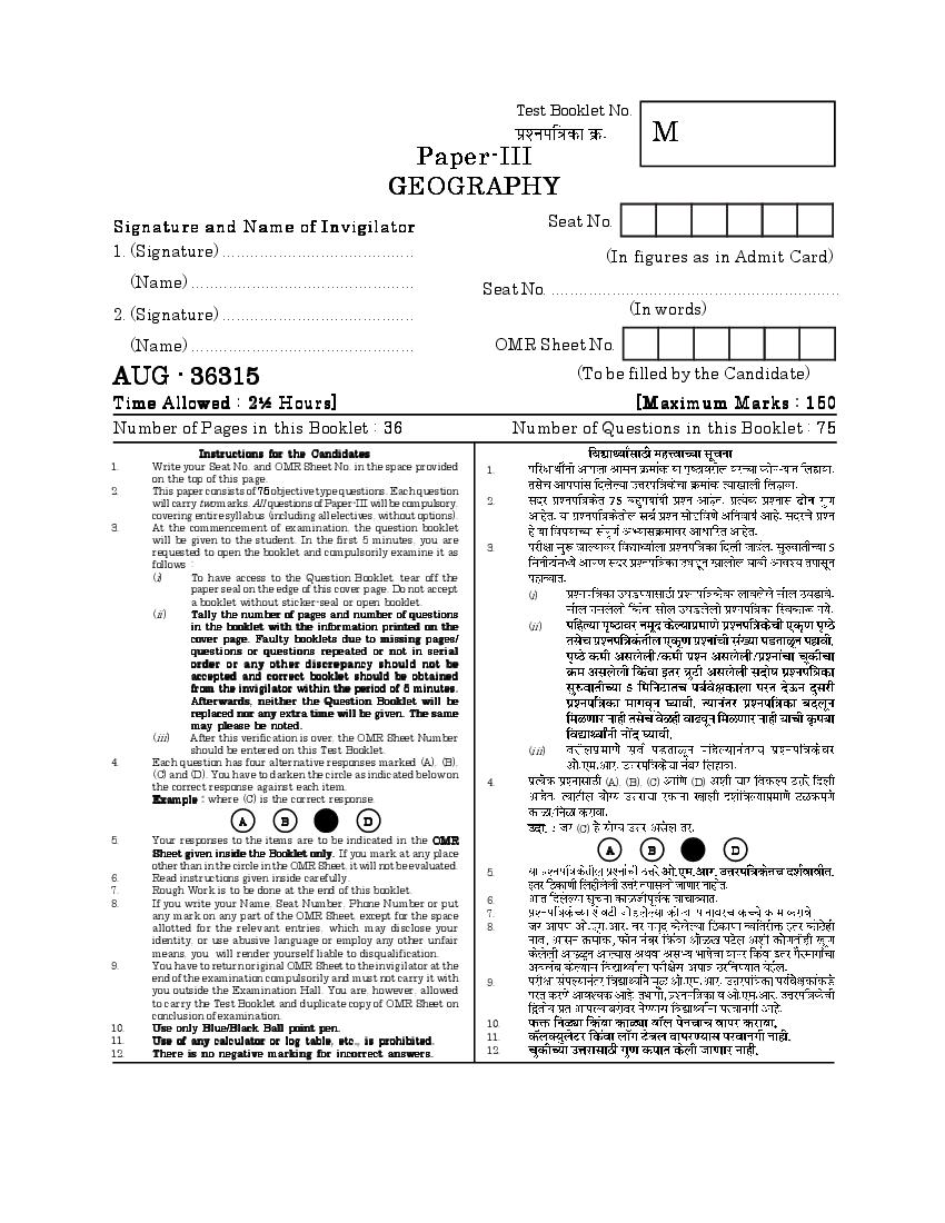
M
GEOGRAPHY
Signature and Name of Invigilator Seat No.
1. (Signature) ......................................... (In figures as in Admit Card)
(Name) ................................................ Seat No. ..............................................................
2. (Signature) ......................................... (In words)
(Name) ................................................ OMR Sheet No.
AUG - 36315 (To be filled by the Candidate)
Time Allowed : 2½ Hours] [Maximum Marks : 150
Number of Pages in this Booklet : 36 Number of Questions in this Booklet : 75
Instructions for the Candidates
1. Write your Seat No. and OMR Sheet No. in the space provided 1.
on the top of this page.
2. This paper consists of 75 objective type questions. Each question
will carry two marks. All questions of Paper-III will be compulsory, 2.
covering entire syllabus (including all electives, without options).
3. At the commencement of examination, the question booklet
will be given to the student. In the first 5 minutes, you are
requested to open the booklet and compulsorily examine it as 3.
follows :
(i) To have access to the Question Booklet, tear off the
paper seal on the edge of this cover page. Do not accept
(i)
a booklet without sticker-seal or open booklet.
(ii) Tally the number of pages and number of questions
in the booklet with the information printed on the (ii)
cover page. Faulty booklets due to missing pages/
questions or questions repeated or not in serial
order or any other discre pancy should not be
accepted and correct booklet should be obtained
from the invigilator within the period of 5 minutes.
Afterwards, neither the Question Booklet will be
replaced nor any extra time will be given. The same
may please be noted.
(iii) After this verification is over, the OMR Sheet Number
should be entered on this Test Booklet. (iii)
4. Each question has four alternative responses marked (A), (B),
(C) and (D). You have to darken the circle as indicated below on
the correct response against each item. 4. (A), (B), (C) (D)
Example : where (C) is the correct response.
A B D
(C)
5. Your responses to the items are to be indicated in the OMR
Sheet given inside the Booklet only. If you mark at any place A B D
other than in the circle in the OMR Sheet, it will not be evaluated.
5.
6. Read instructions given inside carefully.
7. Rough Work is to be done at the end of this booklet.
8. If you write your Name, Seat Number, Phone Number or put 6.
any mark on any part of the OMR Sheet, except for the space 7.
allotted for the relevant entries, which may disclose your 8.
identity, or use abusive language or employ any other unfair
means, you will render yourself liable to disqualification.
9. You have to return original OMR Sheet to the invigilator at the
end of the examination compulsorily and must not carry it with 9.
you outside the Examination Hall. You are, however, allowed
to carry the Test Booklet and duplicate copy of OMR Sheet on
conclusion of examination.
10. Use only Blue/Black Ball point pen. 10.
11. Use of any calculator or log table, etc., is prohibited. 11.
12. There is no negative marking for incorrect answers. 12.
Page 2
Page 3
Paper III
III
Time Allowed : 2½ Hours] [Maximum Marks : 150
Note : This Paper contains Seventy five (75) multiple choice questions. Each question
carrying Two (2) marks. Attempt All questions.
(75) (2)
1. ‘Present is key to the past’, who has 1.
stated this ?
(A) Hutton (A)
(B) Horton (B)
(C) Davis (C)
(D) Penck (D)
2. Which of the following does not 2.
control the process of erosion ?
(A) Climate (A)
(B) Slope (B)
(C) Nature of material (C)
(D) Location of material (D)
3 [P.T.O.
Page 4
one labelled as Assertion (A) and (A) (R)
the other as Reason (R) :
Assertion (A) : Tsunamis are ‘L’
(A) ‘L’
type of waves.
Reason (R) : Tsunamis are caused
(R)
by sudden vertical movement of the
earth’s crust.
In the context of the above two
statements which one of the
following is correct ?
(A) Both (A) and (R) are true and (A) (A) (R)
(R) is the correct explanation of (R) (A)
(A)
(B) (A) (R)
(B) Both (A) and (R) are true but (R) (A)
(R) is not the correct
explanation of (A)
(C) (A) (R)
(C) (A) is true but (R) is false
(D) (A) (R)
(D) (A) is false but (R) is true
4
Page 5
4.
is a mis-match :
(A) Oxbow lake — Fluvial
landscape (A) —
(B) Evaporites — Arid landscape
(C) Ergs — Glacial
(B) —
landscape
(C) —
(D) Stacks — Coastal
landscape (D) —
5. Downward movement of soil, 5.
regolith and bed rock under the
influence of gravity is called :
(A) Disintegration
(A)
(B) Mass wasting
(B)
(C) Physical weathering
(C)
(D) Exfoliation
(D)
5 [P.T.O.
Page 6
fluvial landscape will lead to the
development of :
(A) Rectangular drainage
pattern (A)
(B) Trellis drainage pattern (B)
(C) Superimposed drainage
(C)
pattern
(D)
(D) Antecedent drainage pattern
7. Triangular shaped polished stones 7.
which appear like miniature
pyramids at the foot of the
mountains in the desert areas are
called as :
(A)
(A) Hamadas
(B)
(B) Ventifacts
(C) Zuegens (C)
(D) Yardangs (D)
6
Page 7
8.
provide explanation for :
(A) Distribution of continents and
oceans
(A)
(B) Distribution of volcanoes and
(B)
earthquakes
(C) Distribution of igneous rocks (C)
(D) Distribution of submerged
(D)
mountain systems
9. Which one of the following would 9.
increase the albedo of earth-
atmosphere system ?
(A) Glacial Shrinking (A)
(B) Deforestation (B)
(C) Thick cloud cover (C)
(D) Water surface when sun is near
(D)
the zenith
7 [P.T.O.
Page 8
one labelled as Assertion (A) and (A) (R)
other as Reason (R) :
Assertion (A) : Unlike Celsius and
(A)
Fahrenheit scales, it is not possible
to have negative values when using
Kelvin scale.
Reason (R) : There is no
temperature lower than absolute (R)
zero.
In the context of the above two
statements which one of the
following is correct ?
(A) (A) (R) (R)
(A) Both (A) and (R) are true and
(A)
(R) is the correct explanation of
(B) (A) (R)
(A)
(R) (A)
(B) Both (A) and (R) are true
but (R) is not the correct (C) (A) (R)
explanation of (A)
(C) (A) is true but (R) is false (D) (A) (R)
(D) (A) is false but (R) is true
8
Page 9
not correctly matched in connection
with the motion of atmosphere ?
(A) (1)
(A) Planetary scale (1) Waves in
westerlies
(B) Synoptic scale (2) Valley and (B) (2)
mountain
breeze
(C) Meso scale (3) Tornado (C) (3)
(D) Micro scale (4) Turbulance (D) (4)
12. Which one of the following is true 12.
for a parcel of rising air but not true
for the surrounding air ?
(A) Temperature value vary
erratically from one level to (A)
other
(B) Consists of different air
(B)
molecules at each level
(C)
(C) Humidity differ erratically from
one level to other
(D) Change in temperature with (D)
altitude under either dry or wet
adiabatic rate
9 [P.T.O.
Page 10
grams of moisture. At that
30
temperature the air would be
saturated with 30 gms of water
vapour. What is the relative
humidity ?
(A) 100%
(A) 100 percent
(B) 30%
(B) 30 percent
(C) 22.5%
(C) 22.5 percent
(D) 25 percent (D) 25%
14. The least common of the ten cloud 14.
genera is :
(A) Cumulonimbus (A)
(B) Cirrocumulus (B)
(C) Altostratus (C)
(D) Nimbostratus (D)
10
Page 11
a mass of cold air moves into a region
occupied by warm air ?
(A) A warm front will be formed
and there will be intense (A)
precipitation
(B) The boundary between the two
(B)
air masses will be a zone of
intense high pressure
(C) The air masses will mix rapidly (C)
forming an air mass of
intermediate temperature
(D) A cold front will be formed as
(D)
the warm air will be forced
upward
16. Which one of the following is a 16. (C)
prerequisite criteria for Koppen’s ‘C’
type of climate ?
(A) Average temperature of coolest
(A)
month is above 18°C
18°C
(B) Average temperature of coolest
(B)
month is –3°C and above
–18°C –3°C –18°C
(C) Average temperature of coolest (C)
month is under 18°C and above 18°C –3°C
–3°C
(D) Average temperature of coolest (D)
month is –18°C or below
–18°C
11 [P.T.O.
Page 12
temperature of ..............
(A) 10°C (A) 10°
(B) 35°C (B) 35°
(C) over 20°C (C) 20°
(D) below 5°C (D) 5°
18. Mangroves ................ 18.
(A) Help to protect shorelines (A)
(B) Grow in lakes and ponds
(C) Are salt resistant species (B)
(D) Are responsible for marine (C)
pollution (D)
19. The length of mid-Atlantic ridge is 19.
about .............
(A) 15,000 km (A) 15,000
(B) 12,000 km (B) 12,000
(C) 800 km (C) 800
(D) 10,000 km (D) 10,000
12
Page 13
zone.
(A) coastal regulation (A)
(B) cyclone reconstruction (B)
(C) calamity relief (C)
(D) central relief (D)
21. Selva forests are : 21.
(A) Broad leaf evergreen forests (A)
(B) Broad leaf deciduous forests (B)
(C) Coniferous evergreen forests (C)
(D) Coniferous deciduous forests (D)
22. The specific place of an organism in 22.
an ecosystem is called :
(A) Niche (A)
(B) Autotroph (B)
(C) Trophic level (C)
(D) Food pyramid (D)
13 [P.T.O.
Page 14
referred to as the ‘producer’ in
marine ecosystem ?
(A)
(A) Small fish
(B)
(B) Fungi
(C) Zooplankton (C)
(D) Phytoplankton (D)
24. Who is known for determining the 24.
latitudes and longitudes of the
earth ?
(A)
(A) Eratosthenes
(B)
(B) Herodotus
(C) Ptolemy (C)
(D) Strabo (D)
25. Which one of the following pairs of 25.
geographers is known as founders of
modern geography ?
(A) Ratzel and Blache (A)
(B) Allen Semple and Ian Burton (B)
(C) Blache and Bruhnes (C)
(D) Carl Ritter and Humboldt
(D)
14
Page 15
revolution’’ was first used by :
(A) James Conant (A)
(B) Ian Burton (B)
(C) Lucien Febvre (C)
(D) Peter Haggett (D)
27. Environmental determinism arose 27.
from the writings of :
(A) Ellen Semple (A)
(B) Ratzel (B)
(C) Preston James (C)
(D) Carl Ritter (D)
28. The debate over methodological 28.
aspects of regional geography is
related to the ...............
(A)
(A) Quantitative analysis
(B)
(B) Environmental determinism
(C)
(C) Areal variations
(D)
(D) Spatial organisation
15 [P.T.O.
Page 16
California was associated with the
studies in :
(A)
(A) Cultural Geography
(B)
(B) Political Geography
(C) Historical Geography (C)
(D) Physical Geography (D)
30. Which one of the following forms 30.
the subject matter of radical
geography ?
(A)
(A) Agricultural problems
(B)
(B) Regional geopolitics
(C) Population growth (C)
(D) Socio-economic inequalities (D)
31. Select the correct order of decreasing
31. 2011
density of population (2011) :
(A) Asia, Europe, Africa, South
America
(A)
(B) Europe, Asia, Africa, South
America
(B)
(C) Asia, Africa, Europe, South
America (C)
(D) Asia, Europe, South America,
Africa (D)
16
Page 17
pyramid has a :
(A) narrow base and wide top (A)
(B) wide base and wide top (B)
(C) wide base and narrow top (C)
(D) narrow base and narrow top (D)
33. Women have a longer life 33.
expectancy than men due to :
(A) Safer life (A)
(B) Genetic sturdiness (B)
(C) Early marriage (C)
(D) Low health hazard (D)
34. The changes in the stages of fertility 34.
and mortality is given by :
(A) Demographic structure model (A)
(B) Demographic dividend model (B)
(C) Demographic transition model (C)
(D) Demographic profile model (D)
17 [P.T.O.
Page 18
situated along :
(A) Canal (A)
(B) River (B)
(C) Railway (C)
(D) Road (D)
36. FSI is the ratio between : 36.
(A) Built-up area allowed and plot
area available (A)
(B) Plot area allowed and open area
available (B)
(C) Built-up area and the open
area (C)
(D) Plot area and built-up area (D)
18
Page 19
the :
(A) Production of goods and services (A)
to a market outside the city
(B) Production of goods and services
(B)
for local population
(C) Tertiary and quarternary
services (C)
(D) Secondary activities (D)
38. ‘Range of good’ in central place 38.
theory means :
(A) Goods ranging from necessity to (A)
luxuries (B)
(B) Wide ranging quality goods
(C) Distance travelled by people to (C)
obtain a service/good
(D) Distance travelled to obtain (D)
diversified goods
39. Which one of the following pairs is 39.
incorrect ?
Tribes Names of Shifting
Cultivation
(A) —
(A) Naga — Jhum
(B) Maria — Penda (B) —
(C) Baiga — Bewar (C) —
(D) Khond — Koman
(D) —
19 [P.T.O.
Page 20
practices commercial grain
forming ?
(A)
(A) Brazil
(B)
(B) Indonesia
(C) Argentina (C)
(D) Finland (D)
41. Which is the most important reason 41.
for the dwindling forest resources
today ?
(A)
(A) Soil erosion
(B)
(B) Overfelling
(C) Forest fires (C)
(D) Floods (D)
42. Which one of the following is a 42.
resource based industry in the
respective country ?
(A)
(A) Wine industry in France
(B)
(B) Paper industry in Japan
(C)
(C) Petroleum refining in Pakistan
(D) Steel industry in Belgium (D)
20
Page 21
43.
renewable resource ?
(A) Water
(A)
(B) Fish
(B)
(C) Bauxite
(C)
(D) Sodium chloride
(D)
44. The highest hydro-electric power
44.
potential in Africa is found in .............
(A) Southern Part
(A)
(B) North-eastern part
(B)
(C) North-western part
(C)
(D) Tropical part
(D)
45. Lines connecting locations of equal
45.
transport costs are called :
(A) isodapanes
(A)
(B) Isotims
(B)
(C) Isohyetes
(C)
(D) Isoquants
(D)
21 [P.T.O.
Page 22
output that leads to decrease in
per unit cost of production is known
as ............
(A)
(A) Diseconomies of scale
(B)
(B) Economies of sustenance
(C) Economic system (C)
(D) Economies of scale (D)
47. A state is a .............. unit. 47.
(A) Sovereign (A)
(B) Democratic (B)
(C) Liberal (C)
(D) Autocratic (D)
48. Frontiers are not characterised by 48.
..............
(A)
(A) rudimentary socio-economic
relations (B)
(B) rebelliousness and lawlessness
(C)
(C) affiliation
(D)
(D) integrating factor
22
Page 23
relation to the nature of their
boundary :
(A) Uruguay and Argentina (A)
(B) Zaire and Congo (B)
(C) Myanmar and Thailand (C)
(D) Switzerland and Germany (D)
50. Jajmani System is based on the 50.
relationship of .............
(A) Patron-client (A)
(B) Landlord-tenant (B)
(C) Landlord-patron (C)
(D) Patron-tenant (D)
51. Which of the following characteristics
51.
are found in developing countries ?
(a) High population growth rates
(b) Large number of people living (a)
in poverty
(b)
(c) Very traditional methods of
agricultural production (c)
(d) Mechanised agricultural (d)
production methods
Select the appropriate option from
the following : (A) (a) (b)
(A) (a) and (b)
(B) (b) (c)
(B) (b) and (c)
(C) (c) (d)
(C) (c) and (d)
(D) (a) and (d) (D) (a) (d)
23 [P.T.O.
Page 24
of spatial interaction ?
(a) Spatial complementarity
(a)
(b) Distance decay
(b)
(c) Diffusion
(c)
(d) Interviewing opportunity
(d)
Select the appropriate option from
the following :
(A) (a) (b)
(A) (a) and (b)
(B) (c) and (d) (B) (c) (d)
(C) (a), (b) and (c) (C) (a), (b) (c)
(D) (a), (b) and (d) (D) (a), (b) (d)
53. Which of the following languages 53.
belongs to Austric family ?
(A) Kinnauri (A)
(B) Kuruba (B)
(C) Munda (C)
(D) Banjari (D)
24
Page 25
majority of French Speaking
population.
(A)
(A) Ontario
(B) Quebec (B)
(C) British Columbia (C)
(D) Alberta (D)
55. Given below are the two statements, 55.
one labelled as Statement (A) and (A) (R)
the other as Reason (R) :
Statement (A) : Regional
(A) :
geography has changed
considerably.
Reason (R) : It now includes both (R) :
analysis and synthesis.
Select the correct alternative using
the codes below :
(A) (A) (R) (R)
(A) Both (A) and (R) are true and (A)
(R) is the correct explanation of
(B) (A) (R)
(A)
(R) (A)
(B) Both (A) and (R) are true, but
(R) is not the correct (C) (A) (R)
explanation of (A)
(C) (A) is true but (R) is false (D) (A) (R)
(D) (A) is false but (R) is true
25 [P.T.O.
Page 26
56.
Production Complex is an extension
of ................
(A)
(A) Central place theory
(B)
(B) Growth pole concept
(C) Core-periphery concept (C)
(D) Diffusion model (D)
57. Give the correct sequence of effects 57.
observed around growth centres :
(A) Agglomeration effect, Backwash (A)
effect, spread effect
(B) Agglomeration effect, spread (B)
effect, backwash effect
(C) Backwash effect, spread effect,
(C)
agglomeration effect
(D) Spread effect, agglomeration
(D)
effect, backwash effect
26
Page 27
58. ...................
development of Uttarakhand.
(A) Poor human resource
(A)
development
(B)
(B) Absence of resource base
(C) Physical isolation (C)
(D) Poverty (D)
59. The main attribute of functional 59.
region is ..............
(A) Functional homogeneity (A)
(B) Functional heterogeneity (B)
(C) Stakeholders’ participation (C)
(D) Functional superiority (D)
60. Who formalised the concept that 60.
there exists relationship between
spatial organisation and national
development ?
(A)
(A) Luten
(B)
(B) Dickens
(C)
(C) Kuklinski
(D)
(D) Friedmann
27 [P.T.O.
Page 28
transport network are :
(A) Natural regions (A)
(B)
(B) Nodal regions
(C)
(C) Planning regions
(D)
(D) Resource regions
62. Which of the following is the correct 62.
sequence of belts from Siwaliks to
active flood plains of North Indian
Plains ?
(A) Bha b a r— Te ra i — K h ad a r —
Bangar (A)
(B) Bh a b a r — T e r a i — B a ng a r —
(B)
Khadar
(C) Ba n g a r — T e ra i — K ha d a r —
(C)
Bhabar
(D) Bhabar—Khadar—Bangar— (D)
Terai
28
Page 29
necessarily confined to the narrow
zone of tidal limits ?
(A) Alpine vegetation (A)
(B) Tropical rainforest (B)
(C) Tropical deciduous (C)
(D) Mangrove (D)
64. Main cause for the winter rains in 64.
the state of Jammu and Kashmir is
that ...........
(A)
(A) the area enjoys mediterranean
climate
(B)
(B) it is the area of high elevation
(C)
(C) it comes under the influence of
sub-tropical westerlies
(D) it comes under the influence of (D)
tropical easterly jet stream
29 [P.T.O.
Page 30
India is primarily due to ..........
(A) Extreme Climatic variability (A)
(B) Exponential urbanisation (B)
(C) Commercial exploitation (C)
(D) Illegal deforestation (D)
66. Which two of the following are the 66.
field-refineries in India ?
(a) Panipat (a)
(b) Mathura
(b)
(c) Koyali
(c)
(d) Digboi
(d)
Select the appropriate places from
the following pairs :
(A) (a) (b)
(A) (a) and (b)
(B) (b) (c)
(B) (b) and (c)
(C) (c) (d)
(C) (c) and (d)
(D) (d) (a)
(D) (d) and (a)
30
Page 31
67.
ecotourism society’s definition of
2015
2015, which of the following is
not direct component of the
ecotourism ?
(A) Well being of the local people
(A)
(B) Conservation of the
environment (B)
(C) Preservation of the
(C)
environment
(D) Responsible travel (D)
68. Which of the following states has 68.
maximum number of major dams in
the country ?
(A)
(A) Karnataka
(B)
(B) Uttar Pradesh
(C)
(C) Himachal Pradesh
(D) Maharashtra (D)
31 [P.T.O.
Page 32
data on maps ............... is the primary
variable which is visually more
effective.
(A)
(A) Shape
(B)
(B) Colour
(C)
(C) Size
(D) Orientation (D)
70. In GIS, the process of assigning the 70.
co-ordinates of locational features to
the corresponding attribute value is
known as ............
(A)
(A) Geo-stitching
(B) Geo-coding (B)
(C) Geo-pairing (C)
(D) Geo-pasting
(D)
32
Page 33
different landuses belongs to ...............
scale of measurement.
(A)
(A) Nominal
(B)
(B) Ordinal
(C)
(C) Interval
(D)
(D) Ratio
72.
72. If the frequencies are concentrated
at number of locations over the
range of data it will be called ..............
distribution.
(A)
(A) Negatively skewed
(B)
(B) Laptokurtic
(C)
(C) Multimodal
(D) Platykurtic (D)
33 [P.T.O.
Page 34
techniques you will use for testing
the validity of a categorisation of
observed values of a variable ?
(A) ‘t’
(A) Students’ t-test
(B) Analysis of variance (B)
(C) Chi-square test (C)
(D) Kolmogorov-Smirnov (KS) test (D) (KS)
74. Which of the following techniques is
74.
best suited for the analysis of
inequality of distribution ?
(A)
(A) Lorenz curve
(B) Scaling technique (B)
(C) Rank order analysis (C)
(D) Weighted score (D)
75. A standard normal distribution will 75.
have :
(A) Mean = 1 and Std. Dev. = 1 (A) = 1 = 1
(B) Mean = 0 and Std. Dev. = 0 (B) = 0 = 0
(C) Mean = 0 and Std. Dev. = 1 (C) = 0 = 1
(D) Mean = 1 and Std. Dev. = 0 (D) = 1 = 0
34
Page 35
35 [P.T.O.
Page 36
36
Document Details
| Board / Org | Maharashtra Exams |
| Exam | Maharashtra State Eligibility Test |
| Type | Question Paper |
| Pages | 36 |
| Updated | 30 Apr 2026 |