CBSE Class 12 Sample Paper 2023 Solution Geography
Finished viewing? Save it for later —
Download CBSE Class 12 Sample Paper 2023 Solution Geography (PDF · 19 pages)About CBSE Class 12 Sample Paper 2023 Solution Geography
CBSE Class 12 Sample Paper 2023 Solution Geography is available here for free download. Published by CBSE for Class 12, this solution can be viewed online or downloaded as a PDF (19 pages). Candidates preparing for Class 12 can use CBSE Class 12 Sample Paper 2023 Solution Geography to understand the exam pattern, the type of questions asked, and the overall difficulty level.
Frequently Asked Questions
How can I download CBSE Class 12 Sample Paper 2023 Solution Geography?
Open this page and click the Download button to save CBSE Class 12 Sample Paper 2023 Solution Geography as a PDF. It is completely free on AglaSem Docs.
Is CBSE Class 12 Sample Paper 2023 Solution Geography free to download?
Yes. CBSE Class 12 Sample Paper 2023 Solution Geography can be viewed online and downloaded as a PDF free of cost on AglaSem Docs.
How many pages does CBSE Class 12 Sample Paper 2023 Solution Geography have?
CBSE Class 12 Sample Paper 2023 Solution Geography contains 19 pages, which you can read online or download together as a single PDF.
Where can I find more Class 12 study material?
You can find more Class 12 question papers, sample papers, syllabus, and answer keys on AglaSem Docs.
CBSE Class 12 Sample Paper 2023 Solution Geography – Text
Read the full text of this solution below — useful to quickly search, copy and reference the content online without downloading the PDF.
📄 View text version (19 pages)
Page 1
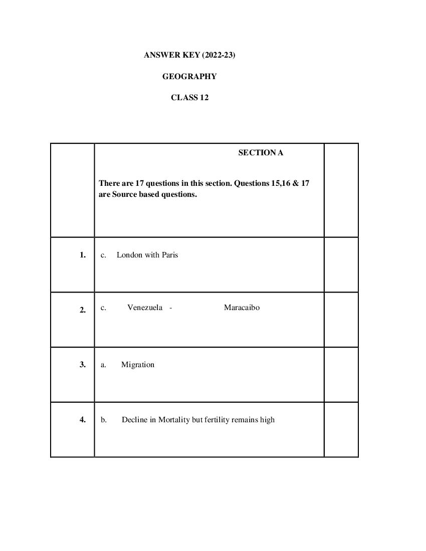
GEOGRAPHY
CLASS 12
SECTION A
There are 17 questions in this section. Questions 15,16 & 17
are Source based questions.
1. c. London with Paris
2. c. Venezuela - Maracaibo
3. a. Migration
4. b. Decline in Mortality but fertility remains high
Page 2
6. c. It is situated at the head of Gulf of Kachchh
7. b. Maharashtra - Korba
8. b. Jaisalmer, Ankaleshwar, Krishna Godavari basin, Tripura
9. a. Hugli, Salem, Bhilai
10. a. Complex way of life, manufacturing of finished goods,
nodes of economic growth.
11. a. (iv) - (ii) - (i) - (iii)
12. b. Both the statements are true and statement II correctly
presents the reason for statement I.
13. c. Both statements are correct. Statement II correctly explains
statement I.
14. d. Both assertion and reason are correct but reason is not the
correct explanation for assertion
15. (b) Watershed development
Page 3
17. (b) Voluntary labour
SECTION B
Question numbers 18-23 are SA type questions. Question 18
& 19 are Source based questions.
18. Read the given Passage carefully and answer the questions that 3
follow:
Bharmaur tribal area comprises Bharmaur and Holi tehsils of
Chamba district of Himachal Pradesh. It has been a notified tribal
area since 21 November 1975. Bharmaur is inhabited by „Gaddi‟,
a tribal community who have maintained a distinct identity in the
Himalayan region as they practiced transhumance and conversed
through Gaddiali dialect. Bharmaur tribal region has harsh
climate conditions, low resource base and fragile environment.
These factors have influenced the society and Economy of the
region. According to the 2011 census, the total population of
Bharmaur sub-division was 39,113 i.e., 21 persons per sq km. It is
one of the most (economically and socially) backward areas of
Himachal Pradesh. Historically, the Gaddis have experienced
geographical and political isolation and socio-economic
deprivation. The economy is largely based on agriculture and
allied activities such as sheep and goat rearing. The process of
development of the tribal area of Bharmaur started in the 1970s
when Gaddis were included among „scheduled tribes‟. Under the
Page 4
and Bharmaur was designated as one of the five Integrated Tribal
Development Projects (ITDP) in Himachal Pradesh. This area
development plan was aimed at improving the quality of life of
the Gaddis and narrowing the gap in the level of development
between Bharmaur and other areas of Himachal Pradesh. This
plan laid the highest priority on development of transport and
communications, agriculture and allied activities, and social and
community services.
1) How have the Gaddi Tribal Community maintained a
distinct identity in the Himalayan region?
ANS: Gaddi tribal communities have maintained a distinct
identity in the Himalayan region as they practiced
transhumance and conversed through Gaddiali dialect.
2) Which factors have influenced the society and Economy
of the region to remain backward?
ANS: Bharmaur tribal region has harsh climate conditions,
low resource base and fragile environment. These factors
have influenced the society and Economy of the region.
3) Under the Integrated Tribal Development Project, Which
areas were given the highest priority?
ANS: This plan laid the highest priority on development
of transport and communications, agriculture and allied
activities, and social and community services.
19. Observe the given map and answer the following questions: 3
Page 5
ANS: Railway Line- Trans-Siberian Railway Line. It Lies
in Asiatic Russia
2) Name the stations marked as „A‟ and „B‟.
Station A is Moscow. Station B is Chita.
3) State two reasons why it is the most important route in
Asia?
● It has helped in opening up its Asian region to west
European markets.
● Chita is an important agro-centre and Irkutsk, a fur
center connecting them to Odessa in the South
Answers for Visually Impaired Students are the same as
above.
20. 1. The density of population is a measure of human and land 3
relationship. It is expressed as the number of persons per unit
area. It helps in getting a better understanding of spatial
distribution of population in relation to land.
2. The physical factors like climate, terrain and availability of
water affects population distribution. For example the north
Page 6
of population than other regions of the country.
3. Economic factors like industrialisation, urbanisation and
development of transport networks cause high concentration
of population in urban regions of Delhi, Mumbai, Kolkata,
Bangalore, Pune etc.
OR
The three stages of the Demographic Transition Theory with
diagram:
The above diagram explains the three-staged model of
Demographic Transition Theory:
● The first stage has high fertility and high mortality
because people reproduce more to compensate for the
deaths due to epidemics and variable food supply. The
population growth is slow and most of the people are
engaged in agriculture where large families are an asset.
Life expectancy is low, people are mostly illiterate and
have low levels of technology. Two hundred years ago all
the countries of the world were in this stage.
● Fertility remains high in the beginning of the second stage
but it declines with time. This is accompanied by a
Page 7
health conditions lead to decline in mortality. Because of
this gap the net addition to population is high.
● In the last stage, both fertility and mortality decline
considerably. The population is either stable or grows
slowly. The population becomes urbanised, literate and
has high technical knowhow and deliberately controls the
family size. This shows that human beings are extremely
flexible and are able to adjust their fertility..
21. The features of cottage manufacturing or household
industries;(any three points)
1. It is the smallest manufacturing unit.
2. Use of local raw materials and simple tools by the artisans.
3. Goods are produced for everyday use in the homes of
artisans with the help of family members.
4. Finished products are used in the same household or sold in
the local market.
5. Some common examples of products produced in this
sector include food stuffs, containers, fabrics, tools, furniture,
figurines, jewellery, pottery etc.
22. Write any three points.
Naturalisation of humans Humanisation of nature
This refers to early stages of This refers to the interaction
interaction between the natural between the forces of nature
environment and humans and humans who begin to
Page 8
dictates of nature. nature.
It indicates a very low level of It indicates development of
technology and social efficient technology and better
development. social and cultural relations.
Naturalised humans listen to Humans move from a state of
nature, are afraid of its fury necessity to a state of freedom.
and worship nature.
Direct dependence of humans Resources are obtained from
on nature. the environment to create
more opportunities.
The physical environment for Humans make use of nature so
naturalised humans becomes that nature gets humanised
mother nature. showing the imprints of
human activities.
OR
“The approaches to the study of human geography have been
evolving over a period of time”. How have these schools of
thought changed the approaches of study to human geography?
● Welfare or humanistic school of thought in human
geography was mainly concerned with the different
aspects of social well-being of the people. These included
aspects such as housing, health and education.
Geographers have already introduced a paper as
Geography of Social well-being in the Post Graduate
curriculum‟.
● Radical school of thought employed Marxian theory to
explain the basic cause of poverty, deprivation and social
inequality. Contemporary social problems were related to
the development of capitalism.
Page 9
lived experience and also on the perception of space by
social categories based on ethnicity, race and religion, etc.
Write any three points
23.
1. The Internet is the most effective and advanced personal
communication system in India.
2. Enables the user to establish direct access to the word of
knowledge and information.
3. It's like a huge central warehouse of data with detailed
information on various topics.
4. Provides information on low cost
5. Its being used increasingly for e-commerce and carrying
out money transactions
SECTION C
Question numbers 24 to 28 are Long Answer based questions.
24. Describe the main characteristics of Intensive Subsistence 5
Agriculture. In which parts of the world this type of agriculture is
practiced?
This type of agriculture is largely found in densely populated
regions of monsoon Asia.
There are two types of intensive subsistence agriculture.
(i) Intensive subsistence agriculture dominated by wet paddy
cultivation:
Page 10
crop.
Land holdings are very small due to the high density of
population.
Farmers work with the help of family labour leading to intensive
use of land.
Use of machinery is limited and most of the agricultural
operations are done by manual labour.
Farm yard manure is used to maintain the fertility of the soil. In
this type of agriculture, the yield per unit area is high but per
labour productivity is low.
(ii) Intensive subsistence agriculture dominated by crops other
than paddy:
Due to the difference in relief, climate, soil and some of the other
geographical factors, it is not practical to grow paddy in many
parts of monsoon Asia.
Wheat, soyabean, barley and sorghum are grown in northern
China, Manchuria, North Korea and North Japan.
In India wheat is grown in western parts of the Indo-Gangetic
plains and millets are grown in dry parts of western and southern
India.
Most of the characteristics of this type of agriculture are similar to
those dominated by wet paddy except that irrigation is often used.
25. Discuss the problems of Slums and Urban Waste Disposal in 5
developing countries like India.
ANS: The slums, jhuggi-jhopari clusters and colonies of shanty
structures is a major problem faced by the urban settlements in
developing countries like India. These are inhabited by those
people who were forced to migrate from the rural areas to these
urban centres in search of livelihood but could not afford proper
Page 11
environmentally incompatible and degraded areas. Slums are
residential areas of the least choice, dilapidated houses, poor
hygienic conditions, poor ventilation, lack of basic amenities, like
drinking water, light and toilet facilities, etc. Open defecation,
unregulated drainage systems and overcrowded narrow street
patterns are serious health and socio environmental hazards. Most
of the slum population works in low-paid, high risk-prone,
unorganised sectors of the urban economy. Consequently, they are
the undernourished, prone to different types of diseases and
illness and can not afford to give proper education to their
children. The poverty makes them vulnerable to drug abuse,
alcoholism, crime, vandalism, escapism, apathy and ultimately
social exclusion.
26. Leading a long and healthy life, being able to gain knowledge 5
and having enough means to be able to live a decent life are
the most important aspects of human development
- FOUR PILLARS OF HUMAN DEVELOPMENT
Just as any building is supported by pillars, the idea of human
development is supported by the concepts of equity,
sustainability, productivity and empowerment.
● Equity refers to making equal access to opportunities
available to everybody. The opportunities available to
people must be equal irrespective of their gender, race,
income and in the Indian case, caste. Yet this is very often
not the case and happens in almost every society. For
example, in any country, it is interesting to see which
group the most of the school dropouts belong to. This
should then lead to an understanding of the reasons for
such behaviour. In India, a large number of women and
persons belonging to socially and economically backward
groups dropout of school. This shows how the choices of
these groups get limited by not having access to
knowledge.
Page 12
opportunities. To have sustainable human development,
each generation must have the same opportunities. All
environmental, financial and human resources must be
used keeping in mind the future. Misuse of any of these
resources will lead to fewer opportunities for future
generations. A good example is about the importance of
sending girls to school. If a community does not stress the
importance of sending its girl children to school, many
opportunities will be lost to these young women when
they grow up. Their career choices will be severely
curtailed and this would affect other aspects of their lives.
So each generation must ensure the availability of choices
and opportunities to its future generations.
● Productivity here means human labour productivity or
productivity in terms of human work. Such productivity
must be constantly enriched by building capabilities in
people. Ultimately, it is people who are the real wealth of
nations. Therefore, efforts to increase their knowledge, or
provide better health facilities ultimately leads to better
work efficiency.
● Empowerment means to have the power to make choices.
Such power comes from increasing freedom and
capability. Good governance and people-oriented policies
are required to empower people. The empowerment of
socially and economically disadvantaged groups is of
special importance.
OR
The ways to measure human development are constantly
being refined and newer ways of capturing different
elements of human development are being researched.
Researchers have found links between the level of
corruption or political freedom in a particular region.
There is also a discussion regarding a political freedom
index and a listing of the most corrupt countries.
The human development index measures attainments in
human development. It reflects what has been achieved in
Page 13
reliable measure. This is because it does not say anything
about the distribution. The human poverty index is related
to the human development index. This index measures the
shortfall in human development. It is a non-income
measure.
The probability of not surviving till the age of 40, the
adult illiteracy rate, the number of people who do not have
access to clean water, and the number of small children
who are underweight are all taken into account to show
the shortfall in human development in any region. Often
the human poverty index is more revealing than the
human development index. Looking at both these
measures of human development together gives an
accurate picture of the human development situation in a
country.
27. Why is the Service Sector in developed and developing countries
growing faster than the manufacturing sector? Explain giving
suitable examples.
● Highly sophisticated machines and technology are
available now. Manufacturing sector which can be
operated and controlled by a few people, due to which
many people earlier employed in the manufacturing sector
are seeking jobs in the service sector.
● Most of the manufacturing companies need a large
number of people in non direct production sector like
clerical, managerial, advertising, sales, legal and financial
experts which have a higher income than the people
employed in direct production.
● The service sector is growing in importance because more
and more females are seeking employment in this sector
which provides a better working environment and high per
capita income than in the manufacturing sector.
● With growing income, people are demanding more
services like medical facilities, entertainment, hospitality
industries, travel and tourism, etc. As a result of which the
Page 14
is a good thing that many people get employment through
these industries. For example, if tourism increases, then
people in the hospitality industry get employment.
● Growth in Service sector indicates a growth in GDP.
Hence, the government makes all efforts to uplift the
service sector by providing provident funds, gratuity ,
pension, etc to the employees. This also increases the per
capita income of the people.
Elaborate any five problems faced by Indian farmers in 5
28.
agriculture.
● Dependence on Erratic Monsoon- Irrigation covers only
about 33 per cent of the cultivated area in India. The crop
production in the rest of the cultivated land directly
depends on rain. Poor performance of south-west
monsoon also adversely affects the supply of canal water
for irrigation. On the other hand, the rainfall in Rajasthan
and other drought prone areas is too meagre and highly
unreliable. Even the areas receiving high annual rainfall
experience considerable fluctuations. This makes them
vulnerable to both droughts and floods. Drought is a
common phenomenon in the low rainfall areas, which may
also experience occasional floods. The flash floods in
drylands of Maharashtra, Gujarat and Rajasthan in 2006
and 2017 are examples of this phenomenon. Droughts and
floods continue to be the twin menace in Indian
agriculture.
● Low productivity- The yield of the crops in the country is
low in comparison to the international level. Per hectare
output of most of the crops such as rice, wheat, cotton and
Page 15
Russia and Japan. Because of the very high pressure on
the land resources, the labour productivity in Indian
agriculture is also very low in comparison to international
level. The vast rainfed areas of the country, particularly
drylands which mostly grow coarse cereals, pulses and
oilseeds have low yields.
● Constraints of Financial Resources and Indebtedness-
The inputs of modern agriculture are very expensive. This
resource intensive approach has become unmanageable for
marginal and small farmers as they have very meagre or
no savings to invest in agriculture. To tide over these
difficulties, most of such farmers have resorted to availing
credit from various institutions and moneylenders. Crop
failures and low returns from agriculture have forced them
to fall in the trap of indebtedness.
● Lack of Land Reforms- Indian peasantry had been
exploited for a long time as there had been unequal
distribution of land. Among the three revenue systems
operational during the British period, i.e., Mahalwari,
Ryotwari and Zamindari, the last one was most
exploitative for the peasants. After Independence, land
reforms were accorded priority, but these reforms were not
implemented effectively due to lack of strong political
will. Most of the state governments avoided taking
politically tough decisions which went against strong
political lobbies of landlords. Lack of implementation of
land reforms has resulted in continuation of iniquitous
distribution of cultivable land which is detrimental to
agricultural development.
Page 16
small farmers in the country. The average size of land
holding is shrinking under increasing population pressure.
Furthermore, in India, the land holdings are mostly
fragmented. There are some states where consolidation of
holding has not been carried out even once. Even in the
states where it has been carried out once, second
consolidation is required as land holdings have
fragmented again in the process of division of land among
the owners of next generations. The small size of
fragmented landholdings are uneconomic.
● Lack of Commercialisation- A large number of farmers
produce crops for self-consumption. These farmers do not
have enough land resources to produce more than their
requirement. Most of the small and marginal farmers grow
foodgrains, which are meant for their own family
consumption. Modernisation and commercialisation of
agriculture have, however, taken place in the irrigated
areas.
● Vast Underemployment- There is a massive
underemployment in the agricultural sector in India,
particularly in the unirrigated tracts. In these areas, there is
seasonal unemployment ranging from 4 to 8 months. Even
in the cropping season, work is not available throughout as
agricultural operations are not labour intensive. Hence, the
people engaged in agriculture do not have the opportunity
to work round the year. (Any 5 points)
On the basis of the main source of moisture for crops, the farming
can be classified as irrigated and rainfed (barani).
Page 17
based on the objective of irrigation, i.e., protective or productive.
The objective of protective irrigation is to protect the crops from
adverse effects of soil moisture deficiency which often means that
irrigation acts as a supplementary source of water over and above
the rainfall. The strategy of this kind of irrigation is to provide
soil moisture to the maximum possible area.
Productive irrigation is meant to provide sufficient soil moisture
in the cropping season to achieve high productivity. In such
irrigation the water input per unit area of cultivated land is higher
than protective irrigation.
Rainfed farming is further classified on the basis of adequacy of
soil moisture during cropping season into dryland and wetland
farming. In India, the dryland farming is largely confined to the
regions having annual rainfall less than 75 cm. These regions
grow hardy and drought resistant crops such as ragi, bajra,
moong, gram and guar (fodder crops) and practise various
measures of soil moisture conservation and rainwater harvesting.
In wetland farming, the rainfall is in excess of the soil moisture
requirement of plants during the rainy season. Such regions may
face flood and soil erosion hazards. These areas grow various
water intensive crops such as rice, jute and sugarcane and practise
aquaculture in the freshwater bodies.
SECTION D
Question numbers 29 & 30 are Map based questions having 5
sub-parts each.
Page 18
seven features are shown. Identify any five of these features and
write their correct names on the lines marked near each feature.
A. A Shipping Canal - Panama Canal
B. An International Airport - Frankfurt Airport
C. An International Seaport - Hong Kong Port
D. An area of Extensive Commercial Grain farming - Downs
E. A Nomadic Herding area - Sub Sahara or Sahara Desert
F. Largest Country of South America - Brazil
A Major Seaport - Sydney Port
G.
Answers for Visually Impaired Students are the same as
above.
30. On the outline political map of India provided to you, locate and
label any five of the following with appropriate symbols :
Northern most Seaport on Western coast of India - Kandla
A.
Page 19
B.
A market based oil refinery located in Bihar - Barauni
C.
D. State with lowest population density - Arunanchal Pradesh
E. Largest coffee producing state - Karnataka
F. An international airport of Kerala - Tiruanantpuram
G. A state with highest level of urbanization - Goa
Answers for Visually Impaired Students are the same as
above.
Document Details
| Board / Org | CBSE |
| Exam | Class 12 |
| Type | Solution |
| Pages | 19 |
| Updated | 22 Jul 2026 |