Kerala SET 2019 Jul Question Paper _9_
Finished viewing? Save it for later —
Download Kerala SET 2019 Jul Question Paper _9_ (PDF · 12 pages)About Kerala SET 2019 Jul Question Paper _9_
Kerala SET 2019 Jul Question Paper _9_ is available here for free download. Published by Default for Govt Jobs Exams, this question paper can be viewed online or downloaded as a PDF (12 pages). Candidates preparing for Govt Jobs Exams can use Kerala SET 2019 Jul Question Paper _9_ to understand the exam pattern, the type of questions asked, and the overall difficulty level.
Frequently Asked Questions
How can I download Kerala SET 2019 Jul Question Paper _9_?
Open this page and click the Download button to save Kerala SET 2019 Jul Question Paper _9_ as a PDF. It is completely free on AglaSem Docs.
Is Kerala SET 2019 Jul Question Paper _9_ free to download?
Yes. Kerala SET 2019 Jul Question Paper _9_ can be viewed online and downloaded as a PDF free of cost on AglaSem Docs.
How many pages does Kerala SET 2019 Jul Question Paper _9_ have?
Kerala SET 2019 Jul Question Paper _9_ contains 12 pages, which you can read online or download together as a single PDF.
Where can I find more Govt Jobs Exams study material?
You can find more Govt Jobs Exams question papers, sample papers, syllabus, and answer keys on AglaSem Docs.
Kerala SET 2019 Jul Question Paper _9_ – Text
Read the full text of this question paper below — useful to quickly search, copy and reference the content online without downloading the PDF.
📄 View text version (12 pages)
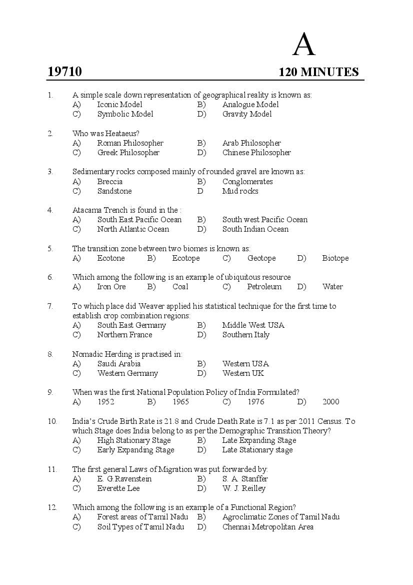
Page 1
19710 120 MINUTES
1. A simple scale down representation of geographical reality is known as:
A) Iconic Model B) Analogue Model
C) Symbolic Model D) Gravity Model
2. Who was Heataeus?
A) Roman Philosopher B) Arab Philosopher
C) Greek Philosopher D) Chinese Philosopher
3. Sedimentary rocks composed mainly of rounded gravel are known as:
A) Breccia B) Conglomerates
C) Sandstone D Mud rocks
4. Atacama Trench is found in the :
A) South East Pacific Ocean B) South west Pacific Ocean
C) North Atlantic Ocean D) South Indian Ocean
5. The transition zone between two biomes is known as:
A) Ecotone B) Ecotope C) Geotope D) Biotope
6. Which among the following is an example of ubiquitous resource
A) Iron Ore B) Coal C) Petroleum D) Water
7. To which place did Weaver applied his statistical technique for the first time to
establish crop combination regions:
A) South East Germany B) Middle West USA
C) Northern France D) Southern Italy
8. Nomadic Herding is practised in:
A) Saudi Arabia B) Western USA
C) Western Germany D) Western UK
9. When was the first National Population Policy of India Formulated?
A) 1952 B) 1965 C) 1976 D) 2000
10. India’s Crude Birth Rate is 21.8 and Crude Death Rate is 7.1 as per 2011 Census. To
which Stage does India belong to as per the Demographic Transition Theory?
A) High Stationary Stage B) Late Expanding Stage
C) Early Expanding Stage D) Late Stationary stage
11. The first general Laws of Migration was put forwarded by:
A) E. G.Ravenstein B) S. A. Stanffer
C) Everette Lee D) W. J. Reilley
12. Which among the following is an example of a Functional Region?
A) Forest areas of Tamil Nadu B) Agroclimatic Zones of Tamil Nadu
C) Soil Types of Tamil Nadu D) Chennai Metropolitan Area
Page 2
A) Peter Haggett B) Francis Perroux
C) Richard Chorley D) Von Thunen
14. Which among the following programmes is aimed at providing Insurance Cover to rabi
& khraif crops and financial support to farmers in case of crop damage.
A) Pradhan Manthri Fasal Bhima Yojana (PMFBY)
B) Pradhan Manthri Gram Sinachi Yojana (PMGSY)
C) Pradhan Manthri Garib Kalyan Yojana (PMGKY)
D) Kissan Vikas Pathra (KVP)
15. Urban population in India as per 2011 Census is -----%.
A) 31.2 B) 23.7 C) 25.8 D) 27.8
16. Which among the following assumptions are wrong with regard to Christaller’s
Central Place Theory?
1. There should be an unbounded isotrophic plain with a homogeneous
distribution of purchasing power.
2. Un-minimised consumer movement
3. Central goods to be purchased at nearest central place.
4. Excess profits are to be earned by any central place.
A) 1&3 B) 2&4 C) 1&4 D) 2&3
17. The Sir Creek forms the boundary between
A) India & Pakistan B) India & China
C) India & Afghanistan D) India & Bangladesh
18. Sharda Canal is located in the State of:
A) West Bengal B) Tamil Nadu
C) Madhya Pradesh D) Uttar Pradesh
19. The State which has the longest length of National Highways in India is
A) Madhya Pradesh B) Andhra Pradesh
C) Maharashtra D) Uttar Pradesh
20. Which among the following is the major type of forest found in Kerala?
A) Tropical Wet Evergreen B) Tropical Moist Deciduous
C) Tropical Dry Deciduous D) Tropical Semi Evergreen
21. Two places are located 15 kms apart on the surface of the earth. They are shown on a
map at 5 cms apart. What will be the scale of the map?
A) 1 : 300,000 B) 1 : 30,000 C) 1 : 3000,000 D) 1 : 3000
22. The process of simplifying too small or too complex feature to be shown on a map is
known as
A) Compilation B) Omittance
C) Selective Selection D) Generalization
2
Page 3
A) Radar B) Infrared C) Microwave D) Sonar
24. Small registration mark exposed on the edges of aerial photograph are known as
A) Principal Marks B) Fiducial Marks
C) Nadir Marks D) Perspective Marks.
25. Which among the following is a Geostationary Satellite?
A) GSAT-31 B) IRS-1D
C) LANDSAT-7 D) SPOT-5
26. Identify the proprietary Image Processing Software from the following
A) ILWIS B) OSSIM
C) ERDAS IMAGINE D) gVSIG
27. The process of converting an analogue map to a digital raster image is known as
A) Scanning B) Digitization
C) Plotting D) Digital Surveying
28. Quad-Tree model is a
A) Vector Compaction Method B) Overlay Analysis Method
C) Network Analysis Method D) Raster Compaction Method
29. The branch of Science that deals with the study of distribution of ancient land and sea is:
A) Palaeontology B) Palaeogeography
C) Palaeoclimatology D) Palaeomagnetism
30. Which among the following is not an indicator in the calculation of Human
Development Index?
A) Life Expectancy at birth
B) Expected years of schooling for school age children and average years of
schooling in the adult population
C) Gross National Income
D) Literacy Rate
31. W. M. Davis’ concept of Cycle of Erosion is based on
A) Darwin's Concept of Evolution
B) Ritter’s Concept of Unity in Diversity
C) Humboldt Concept of Continentality
D) Peter Haggett’s Concept of Spatial Diffusion
32. Sea floor Spreading occurs along
A) Convergent Plate Boundary B) Transform Plate Boundary
C) Divergent Plate Boundary D) Occluded Plate Boundary
33. Yardangs are formed by the action of
A) Running water B) Wind C) Waves D) Glaciers
3
Page 4
level.
Reason: R: Atmosphere is less dense at higher altitudes.
A) A & R are true and R is the correct reason of A
B) A & R are true and R is not the correct reason of A
C) A is true but R is false
D) A is false but R is true
35. An area on the surface of the Earth that can be classified according to the plants and
animals living in it is known as:
A) Ecosystem B) Biome C) Environment D) Niche
36. Following table shows major industrial regions of the world and major urban centres in
them. Match them correctly.
Industrial Regions Urban Centres
a) Mid-Lake Region 1. Cardiff
b) South Wales 2. Baku
c) Caucasus 3. Nagoya
d) Chukyo 4. Pittsburg
A) a-4, b-1, c-2, d-3 B) a-2, b-4, c-1, d-3
C) a-3, b-2, c-4, d-1 D) a-1, b-4, c-3, d-2
37. Which agricultural regionalization technique uses One-Sheet Table for identifying
crop combination region?
A) Weaver’s technique B) Smith’s technique
C) Coppock’s technique D) Doi’s techinique.
38. Identify the statements which are not true with regard to the Green Revolution in India
1. High Yielding Varieties of seeds were used to achieve greater productivity.
2. Focus was on small and poor farmers
3. Attained self-sufficiency in food grain production.
4. Punjab was most beneficial State.
A) 1&4 B) 2&3 C) Only 2 D) 3&4
39. Most populous metropolitan city in India as per 2011 Census:
A) Delhi B) Kolkata C) Mumbai D) Chennai
40. Who put forward the doctrine that the population increases in geometric progression
while food supply increases in arithmetic progression.
A) Edwin Cannon B) Thomas Malthus
C) David Ricardo D) Karl Marx
41. Highest in hierarchy of growth foci is
A) Growth Centres B) Growth Points
C) Local Service Centres D) Growth Poles
4
Page 5
A) To provide hygienic and affordable sanitation facilities for urban poor
B) To provide holistic development of heritage cities
C) To provide better infrastructural facilities
D) To provide affordable home to urban poor
43. A town in India notified by Law by respective State Governments/ UTs and have local
bodies irrespective of demographic characteristics is known as
A) Census Town B) Urban Outgrowth
C) Statutory Town D) Urban Agglomeration
44. To which theory does the statement “If all the urban settlements in an area are ranked
in descending order of population, the population of the nth ranking town will be 1/nth
that of the largest town” pertains to
A) Rank-Size Rule B) Central Place Theory
C) Gravity Model D) Multiple Nuclei Theory
45. The highest peak in Trans-Himalayas is
A) Mt. Nandadevi B) Mt. K2
C) Mt. Everest D) Mt. Kailash
46. The largest rice producer in India:
A) Andhra Pradesh B) Tamil Nadu
C) West Bengal D) Karnataka
47. National Fisheries Development Board is located at:
A) Visakhapatnam B) Hyderabad
C) Kochi D) Mumbai
48. The GI registered pineapple variety in Kerala is:
A) Muthalamada Pineapple B) Neriamangalam Pineapple
C) Vazhakulam Pineapple D) Changalikodan Pineapple
49. A map showing the land use / land cover of India is an example of
A) Special purpose map B) General map
C) Quantitative map D) Qualitative map
50. What is the scale of the Topographic sheet with the number 58/D?
A) 1 : 250,000 B) 1 : 50,000 C) 1 : 25,000 D) 1 : 100,000
51. An example of Active Remote Sensing sensor:
A) LISS B) WiFs C) MSS D) SAR
52. Panchromatic films are
A) Colour Films B) B&W Films
C) Infrared Films D) False Colour Films
53. Spatial resolution of Thermal Infrared Sensor of LANDSAT 9 Satellite is
A) 15 m B) 50 m C) 30 m D) 100 m
5
Page 6
1. Contrast Enhancement
2. Spacial Filtering
3. Unsupervised Classification
4. Supervised Classification
A) 1&3 B) 1&2 C) 2&4 D) 1&4
55. Polygons accidentally created through overlap with existing feature is known as
A) Overshoot Polygon B) Dangling Polygon
C) Sliver Polygon D) None of these
56. Which among the following is a raster data format?
A) .shp B) .tiff C) .dxf D) .tab
57. The study of specific natural or human phenomenon that give rise to certain spatial
patterns and structures on surface of the Earth is called
A) Regional Study B) Global Study
C) Macro Study D) Systematic Study
58. Who is the author of the book ‘Anthropogeographie’?
A) Allen Semple B) Ellsworth Huntington
C) Mark Jefferson D) Friedrich Ratzel
59. The Big Bang Theory of origin on universe was proposed by
A) Georges Lemaitre B) Immanuel Kant
C) Laplace D) Jeans & Geoffrey
60. Match the following:
Geologic Era Geologic Period
a. Cenozoic 1) Carboniferous
b. Mesozoic 2) Cryogenious
c. Paleozoic 3) Quaternary
d. Neoproterozoic 4) Jurassic
A) a-2, b-1, c-4, d-3 B) a-2, b-3, c-4, d-1
C) a-3, b-4, c-1, d-2 D) a-1, b-3, c-2, d-4
61. Who postulated the idea ‘Geographic forms are an expression of the phase and rate of
uplift in relation to the rate of degradation’
A) W.M. Davis B) William D. Thornbury
C) Richard Bailey D) Walther Penk
62. Assertion (A): Alfisols are moderately leached soils found in hardwood forest areas
and have high native fertility.
Reason(R): They are widely used in agriculture and forestry
A) A& R are true and R is the correct explanation of A
B) A& R are true and R is not the correct explanation of A
C) A is true but R is false
D) A is false but R is true.
6
Page 7
A) 4.5% B) 3.5% C) 6.5% D) 8.5%
64. Which type scattering in the atmosphere results in the sky appearing blue?
A) Mie Scattering B) Non-Selective Scattering
C) Rayleigh Scattering D) Selective Scattering
65. The Mojave Desert is in
A) Namibia B) South Africa C) Saudi Arabia D) USA
66. How many RAMSAR Wetland Sites are there in Kerala?
A) 3 B) 2 C) 1 D) 5
67. Weber’s Industrial Location Theory is based on
A) Least transportation cost B) Least management cost
C) Availability of raw materials D) Availability of market
68. Bannargette National Park is in
A) Jharkand B) Madhya Pradesh
C) Karnataka D) Maharashtra
69. As per the nine fold classification of landuse in India, the land which include lands
available for cultivation whether not taken up for cultivation or taken up for cultivation
once but not cultivated during the current year and is not cultivated during the last 5
years in succession is known as
A) Current Fallow
B) Cultivable Waste land
C) Permanent Pastures & Grazing land
D) Fallow other than Current Fallow
70. Match the following
Agricultural Regions of India Area Covered
a) Maize and Coarse Crop region 1. Southern Andhra Pradesh and parts of Tamil Nadu
b) Millets and Oil Seeds Region 2. Kashmir Valley and Assam
c) Fruits and Vegetable Region 3. Deccan Plateau
d) Cotton Region 4. Western Rajasthan and Northern Gujarat
A) a-4, b-1, c-2, d-3 B) a-3, b-4, c-1, d-2
C) a-2, b-3, c-4, d-1 D) a-1, b-3, c-2, d-4
71. Which among the following State recorded highest population growth between
2001-2011 Censuses?
A) Madhya Pradesh B) Andhra Pradesh
C) Uttar Pradesh D) Bihar
72. The term ‘non-ecumene’ refers to:
A) Inhabited places of the earth’s surface
B) Uninhabited places on the surface of the earth
C) Mining areas
D) Cultivated areas
7
Page 8
A) Water Retention Capacity B) Moisture Holding Capacity
C) Field Capacity D) Saturation Capacity
74. Spread and Back Wash Effect is associated with
A) Myrdal Theory B) Central Place Theory
C) Gravity Model D) Growth Pole Theory
75. Which among the following statements are true with regard to Planning in India?
1. It had been essentially normative single level economic planning
2. It had heavy dependence on sectoral approach
3. Planning is centralized at national level
4. Multi-level planning is not yet attempted in large scale
A) 1 & 4 only B) 1 & 3 only
C) 2 & 4 only D) 1, 2 & 3 only
76. One among the following is not an urban development programme. Identify it
A) JNNRUM B) PMJAY C) AMRUT D) NUSP
77. What is the share of urban population in Kerala as per 2011 Census?
A) 31.16 B) 47.72 C) 25.71 D) 52.28
78. The Sector Model of urban landuse was proposed by
A) E. W. Burgess B) C. D. Harris & E. L. Ullmann
C) H. Hoyt D) Torsten Haggerstrand
79. The source region of River Narmada is
A) Mahabaleswar B) Amarkantak
C) Trimbata Plateau D) Dhandakaranya
80. The ‘Amw’ type of climate as per Koeppen’s Climatic classification is experienced in
A) Western Coastal Region south of Mumbai
B) Coastal Tamil Nadu and coastal Andhra Pradesh
C) Peninsular Plateau Region
D) Ganga Plain, eastern Rajasthan, Assam and Madhya Pradesh
81. The largest producer of Sugarcane in India:
A) Tamil Nadu B) Maharashtra
C) Uttar Pradesh D) West Bengal
82. The Government Authority responsible for the management of steel plants in India:
A) TISSCO B) IISCO C) VSP D) SAIL
83. Gandhakasala is an indigenous variety of
A) Plantain B) Rice C) Cardamom D) Pepper
84. The average sex ratio in India as per 2011 Census is:
A) 933 B) 943 C) 929 D) None of these
8
Page 9
A) Marayoor B) Ambalavayal C) Iritty D) Nelliampathy
86. Identify the map projection based on its properties given below
1. Latitudes are drawn as concentric circles
2. Longitudes are straight lines drawn radially from the centre
3. Area is exaggerated away from the centre
4. The scale is correct along the meridians
A) Zenithal Equidistant Projection Equatorial Case
B) Zenithal Equal Area Projection Equatorial Case
C) Zenithal Equidistant Projection Polar Case
D) Zenithal Equal Area Projection Polar Case
87. Carrying capacity of land refers to
A) The number of people that a unit area of land can support in a given
technological level and system of landuse
B) The amount of fertilizer that a unit area of land can hold
C) The amount of moisture that the soil of a given land can hold
D) The number buildings that a given land can hold
88. Green vegetation appear as red in FCC because
A) Vegetation absorbs electromagnetic radiation in the blue band
B) Vegetation reflects electromagnetic radiation in the green band
C) Vegetation reflects almost all energy at infrared band
D) Vegetation absorbs all the incoming energy in the visible spectrum
89. To which country does the GLONASS Navigation System belong?
A) USA B) Japan C) Israel D) Russia
90. What will be the scale of aerial photograph when the focal length of the camera is
150 mm and flying height of the aircraft is 7500 meters?
A) 1:25,000 B) 1:50,000 C) 1: 7500 D) 1: 75,000
91. Which projection is used in the Survey of India OSM maps?
A) UTM Projection B) Polyconic Projection
C) Mollweid’s Projection D) Bonne’s Projection
92. Which among the following are the characteristics of a vertical aerial photograph?
1. Optical axis deviates <300 from the vertical axis
2. Horizon does not appear on the photograph
3. Shape of the area photographed will be square
4. Scale decreases from foreground to background
A) 1 & 4 only B) 2 & 4 only C) 2&3 only D) 1&3 only
93. The Swath of LISS IV sensor of Resourcesat-2 satellite is
A) 70 km B) 140 km C) 840 km D) 740 km
9
Page 10
A) 10-255 B) 1-100 C) 255-355 D) 0-255
95. How many segments are there in GPS?
A) 2 B) 3 C) 4 D) 6
96. Who among the following opined that ‘the physical and cultural phenomena are in a
state of perpetual change and they must be studied in the temporal change, instead of
taking them as state in time scale’?
A) Jean Brunhes B) Vidal-de-Lablache
C) Allen Semple D) W. M. Davis
97. Who is the author of the book ‘Kosmos’?
A) Varenius B) Alexander von Humboldt
C) Carl O. Sauer D) Richard Hartshone
98. Which among the following is not a characteristic of ‘P’ waves?
A) It can move through solids and liquids
B) They are fastest waves
C) It can move particles perpendicular to the direction that the wave is travelling
D) They are compressional waves
99. The pattern of drainage developed as a result of symmetrical erosion around uplift
domes and volcanic cones are known as
A) Dendritic Pattern B) Trellis Pattern
C) Rectangular Pattern D) Radial Pattern
100. Rills are formed by
A) Glacial Erosion B) Fluvial Erosion
C) Aeolian Erosion D) Wave Erosion
101. Which among the following is not a warm ocean current?
A) East Australian Current B) Brazil Current
C) Agulhas Current D) Labrador Current
102. How many Land Capability Classes are there in the scheme followed in India?
A) 8 B) 7 C) 5 D) 10
103. Identify the natural surface which has high albedo among the following
A) Ice Cap
B) Equatorial Forest
C) Water Bodies
D) Soil with high moisture content
104. Which among the following is not an ex-situ conservation method?
A) Seed Gene Bank B) Field Gene Bank
C) Botanical Garden D) Wild Life Sanctuary
10
Page 11
A) Least labour cost
B) Size and shape of market area
C) Maximum availability of raw materials
D) Maximum availability of capital
106. Identify the criteria listed below which are true with regard to defining a census town
in India
1. It should have a population of at least 50,000
2. At least 75% of the male working population should be engaged in non-
agricultural activities
3. It should have a density of at least 400 person per sq. km.
4. It should have area of at least 5 sq. km.
A) 2 & 3 only B) 1 & 4 only
C) 1 & 3 only D) 2 & 4 only
107. A continuous urban spread in India and its adjoining out growth of two or more
physically contiguous towns are termed as
A) Conurbation B) Urban Out Growth
C) Urban Agglomeration D) Metropolitan City
108. Which State has more than 50% its area under tea?
A) Tamil Nadu B) Kerala C) Karnataka D) Assam
109. The first fertilizer factory India under FCIL was setup in
A) Sindri B) Ramagudam C) Talchar D) Korba
110. The Industrial Region known as the ‘Ruhr of India’ is
A) Gujarat Industrial Region B) Chotanagpur Industrial Region
C) Hugli Industrial Region D) Mumbai-Pune Industrial Region
111. Which spatial entity represents the feature that has an area?
A) Line B) Closely spaced points
C) Polygon D) Surface
112. Identify the dams which are part of the Damodar Valley Project.
1. Tilaiya Dam 2. Maithan dam
3. Rihand Dam 4. Sardar Sarovar Dam
A) 1&2 B) 1 &3 C) 2&4 D) 1&4
113. Thornthwait’s Climatic Classification is based on the calculation of
A) Index of Humidity B) Index of Aridity
C) Moisture Index D) Index of Wetness
114. The cold strong north easterly wind that descends to the Adriatic Sea from the Alps
Mountains is known as
A) Foehn B) Bora C) Chinook D) Mistral
11
Page 12
A) 2002-2007 B) 2007-2012
C) 2012-2017 D) 2016-2021
116. Which among the following are a mid-level clouds?
1. Cirrocumulus 2. Altostratus
3. Stratocumulus 4. Altocumulus
A) 1&3 B) 1&4 C) 2&3 D) 2&4
117. The topological relationship that occurs when neighbouring polygons share a common
boundary is known as
A) Containment B) Connectivity C) Coverage D) Adjacency
118. To which School of Geography does Halford J. Mackinder belongs to?
A) German School B) British School
C) French School D) American School
119. Fog that occurs when the sky is clear in relatively still air and the nocturnal cooling of
the ground results in chilling of the layer of air near the ground surface is
A) Radiation Fog B) Advection Fog
C) Adiabatic Fog D) Frontal Fog
120. How many Census Towns are there in Kerala as per 2011 Census?
A) 365 B) 218 C) 461 D) 378
________________________
12
Document Details
| Board / Org | Default |
| Exam | Govt Jobs Exams |
| Type | Question Paper |
| Pages | 12 |
| Updated | 22 Jul 2026 |