Kerala SET 2019 Feb Question Paper Geology
Finished viewing? Save it for later —
Download Kerala SET 2019 Feb Question Paper Geology (PDF · 13 pages)About Kerala SET 2019 Feb Question Paper Geology
Kerala SET 2019 Feb Question Paper Geology is available here for free download. Published by Kerala Exams for Kerala SET, this question paper can be viewed online or downloaded as a PDF (13 pages). Candidates preparing for Kerala SET can use Kerala SET 2019 Feb Question Paper Geology to understand the exam pattern, the type of questions asked, and the overall difficulty level.
Frequently Asked Questions
How can I download Kerala SET 2019 Feb Question Paper Geology?
Open this page and click the Download button to save Kerala SET 2019 Feb Question Paper Geology as a PDF. It is completely free on AglaSem Docs.
Is Kerala SET 2019 Feb Question Paper Geology free to download?
Yes. Kerala SET 2019 Feb Question Paper Geology can be viewed online and downloaded as a PDF free of cost on AglaSem Docs.
How many pages does Kerala SET 2019 Feb Question Paper Geology have?
Kerala SET 2019 Feb Question Paper Geology contains 13 pages, which you can read online or download together as a single PDF.
Where can I find more Kerala SET study material?
You can find more Kerala SET question papers, sample papers, syllabus, and answer keys on AglaSem Docs.
Kerala SET 2019 Feb Question Paper Geology – Text
Read the full text of this question paper below — useful to quickly search, copy and reference the content online without downloading the PDF.
📄 View text version (13 pages)
Page 1
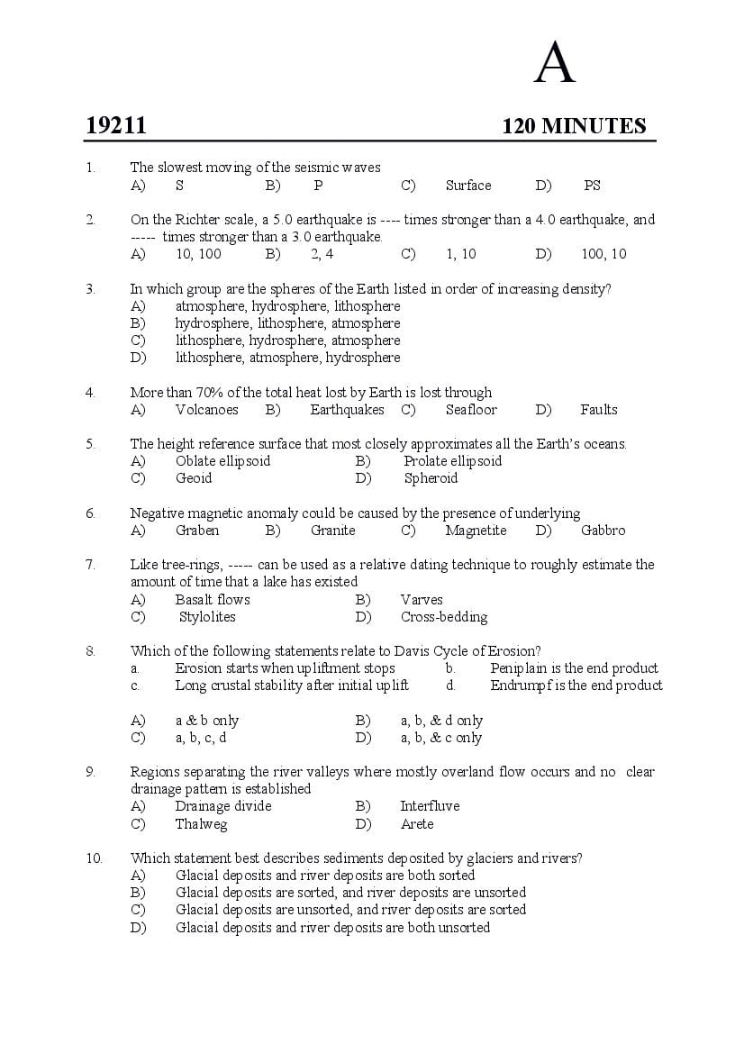
19211 120 MINUTES
1. The slowest moving of the seismic waves
A) S B) P C) Surface D) PS
2. On the Richter scale, a 5.0 earthquake is ---- times stronger than a 4.0 earthquake, and
----- times stronger than a 3.0 earthquake.
A) 10, 100 B) 2, 4 C) 1, 10 D) 100, 10
3. In which group are the spheres of the Earth listed in order of increasing density?
A) atmosphere, hydrosphere, lithosphere
B) hydrosphere, lithosphere, atmosphere
C) lithosphere, hydrosphere, atmosphere
D) lithosphere, atmosphere, hydrosphere
4. More than 70% of the total heat lost by Earth is lost through
A) Volcanoes B) Earthquakes C) Seafloor D) Faults
5. The height reference surface that most closely approximates all the Earth’s oceans.
A) Oblate ellipsoid B) Prolate ellipsoid
C) Geoid D) Spheroid
6. Negative magnetic anomaly could be caused by the presence of underlying
A) Graben B) Granite C) Magnetite D) Gabbro
7. Like tree-rings, ----- can be used as a relative dating technique to roughly estimate the
amount of time that a lake has existed
A) Basalt flows B) Varves
C) Stylolites D) Cross-bedding
8. Which of the following statements relate to Davis Cycle of Erosion?
a. Erosion starts when upliftment stops b. Peniplain is the end product
c. Long crustal stability after initial uplift d. Endrumpf is the end product
A) a & b only B) a, b, & d only
C) a, b, c, d D) a, b, & c only
9. Regions separating the river valleys where mostly overland flow occurs and no clear
drainage pattern is established
A) Drainage divide B) Interfluve
C) Thalweg D) Arete
10. Which statement best describes sediments deposited by glaciers and rivers?
A) Glacial deposits and river deposits are both sorted
B) Glacial deposits are sorted, and river deposits are unsorted
C) Glacial deposits are unsorted, and river deposits are sorted
D) Glacial deposits and river deposits are both unsorted
Page 2
A) Intermountain basin B) Palaeolake
C) Playa D) Salt water lake
12. Increasing 16O values from negative to positive numbers in older to younger soil
carbonates of the Siwaliks indicate
A) Reduced rainfall B) Increased rainfall
C) Lack of rainfall D) Increased evaporation
13. The evidence for Big Bang is that the universe is
A) contracting and and has a pervasive background radiation of 2.7 K below
absolute zero
B) expanding and has a pervasive background radiation of 2.7 K above absolute
zero
C) pulsating and has remained without any change of background radiation
D) contracting and background radiation is erratic
14. Olympus Mons is three times the height of Mount Everest and its caldera is more than
90 kilometers wide. Where is it located?
A) Mars B) Marianas Trench
C) Moon D) Venus
15. Most comets come from a spherical region over a thousand times farther from the Sun
than Pluto. This remote zone is called the -----.
A) Milky way B) Black hole C) Oort cloud D) Asteroid belt
16. Kamacite and taenite are mineral constituents of
A) Stony meteorites B) Iron meteorites
C) Stony-iron meteorites D) Mesosiderites
17. Most of the Earth’s surface ocean currents are caused by
A) stream flow from continents
B) differences in ocean-water density
C) the revolution of the Earth
D) the prevailing winds
18. Oceanic and continental crust differ in
A) composition B) density C) thickness D) all of the above
19. Barrier islands form
A) on gently sloping continental shelves with abundant sand in areas where both
tidal fluctuations and wave-energy levels are low
B) on continental rise, with high levels of wave energy and tidal range
C) around atolls, with deep waters and no sediment supply
D) on drowned coasts
20. An earthquake’s P-wave travelled 4,800 kilometers and arrived at a seismic station at
evening 5:10. At approximately what time did the earthquake occur?
A) 5:02 PM B) 5:08 PM C) 5:10 PM D) 5.18 PM
2
Page 3
in oceanic chemistry?
A) Increased precipitation of calcium carbonate
B) Decreased pH
C) Decreased salinity
D) Increased salinity
22. The most productive areas of the ocean?
A) Estuaries
B) Deep Open Ocean
C) Coastal Downwelling Regions
D) Coastal Upwelling Regions
23. Characteristic clay mineral of chemical weathering in subtropical, rainy climate
A) Illite B) Smectite C) Palygorskite D) Kaolinite
24. Which amongst the following is not a carbonate ooze?
A) foraminifera B) dinoflagellate
C) coccolithophorids D) pteropods
25. Higher contents of dissolved oxygen does not match which amongst these?
A) Less salinity B) More photosynthesis
C) Higher mineral content D) Lower temperature
26. a ≠ b ≠ c, α = β = γ = 90º represents the crystal system of
A) Isometric B) Tetragonal
C) Orthorhombic D) Monoclinic
27. The number of primitive space lattices
A) 7 B) 3 C) 10 D) 1
28. Co-ordination number of a crystalline solid is
A) Number of particles in the unit cell
B) Number of nearest neighbours of a particle
C) Number of octahedral voids in a unit cell
D) Number of tetrahedral voids in a unit cell
29. Which of the following is a crystalline solid?
A) Copper wire B) Glass bottle
C) Polythene bag D) Rubber ball
30. The smallest portion of a crystal which when repeated in different directions generates
the entire crystal
A) Lattice points B) Crystal lattice
C) Unit cell D) None of the mentioned
31. The crystal system of biotite
A) Cubic B) Hexagonal
C) Orthorhombic D) Monoclinic
3
Page 4
Group I Group II
a. Olivine 1. Nesosilicate
b. Quartz 2. Tectosilicate
c. Epidote 3. Sorosilicate
d. Biotite 4. Phyllosilicate
A) a-1, b-2, c-3, d-4 B) a-2, b-3, c-4, d-1
C) a-4, b-2, c-1, d-3 D) a-3, b-1, c-4, d-2
33. A snow ball garnet represents
A) Post-kinematic mineral growth
B) Pre-kinematic mineral growth
C) Syn-kinematic mineral growth
D) Non-kinematic mineral growth
34. Which amongst the following is strongly pleochroic?
A) Muscovite B) Quartz C) Orthoclase D) Hornblende
35. Total number of Bravais lattices
A) 12 B) 13 C) 14 D) 16
36. Which is correctly matched?
A) Sillimanite – Monoclinic
B) Orthoclase – High relief
C) Pyroxene – Near orthogonal cleavage
D) Garnet – Basal cleavage
37. Match the correct items
Group I Group II
a. XRF 1. Spot analysis
b. XRD 2. Structure
c. ICP 3. Solution-based
d. EPMA 4. Chemistry of powder
A) a-3, b-1, c-4, d-2 B) a-1, b-2, c-3, d-4
C) a-4, b-1, c-3, d-2 D) a-4, b-2, c-3, d-1
38. Most rock forming minerals are
A) silicates and oxides B) sulphides and oxides
C) silicates and sulphides D) oxides and hydroxides
39. Monazite is a
A) variety of igneous rock B) phosphate of Th, Y, La, Ce
C) oxide of Th, Y, La, Ce D) variety of metamorphic rock
40. In Moh’s hardness scale the hardest oxide is
A) Diamond B) Corundum C) Quartz D) Topaz
4
Page 5
A) sphere B) ellipsoid
C) oblate spheroid D) prolate spheroid
42. Calc-alkaline basalts are
A) high k-basalts B) low k-basalts
C) low alumina basalts D) high alumina basalts
43. Match the following
Group I Group II
a. Granite 1. Dacite
b. Tonalite 2. Andesite
c. Syenite 3. Trachyte
d. Diorite 4. Rhyolite
A) a-3, b-1, c-2, d-4 B) a-4, b-1, c-3, d-2
C) a-4, b-2, c-3, d-1 D) a-1, b-4, c-3, d-2
44. Match the rock and mineral assemblage
Group I Group II
a. Granodiorite 1. Hornblende – plagioclase
b. Harzburgite 2. Plagioclase – Quartz
c. Gabbro 3. Olivine – Orthopyroxene
d. Diorite 4. Clinopyroxene – Plagioclase
A) a-2, b-3, c-4, d-1 B) a-3, b-4, c-1, d-2
C) a-4, b-1, c-3, d-2 D) a-1, b-3, c-2, d-4
45. Ophiolite sequence top to bottom
A) Radiolarian chert – pillow basalt – dolerite dyke – gabbro – peridotite
B) Peridotite – pillow basalt – gabbro – dolerite dyke – radiolarian chert
C) Pillow basalt – radiolarian chert – dolerite dyke – gabbro – peridotite
D) Gabbro – pillow basalt – dolerite dyke – radiolarian chert – peridotite
46. The differentiation index is the sum of weight percentages of the normative minerals
A) Quartz + orthoclase + albite + nepheline + leucite + kalsilite
B) Sum of any three of the above
C) Sum of any two
D) Sum of (Quartz + Orthoclase + Albite + Leucite)
47. A phaneritic igneous rock with orthoclase, oligoclase, biotite, hornblende, and quartz
A) monzonite B) syenite C) latite D) granodiorite
48. Which of the following shows complete solid solution series?
A) Albite – Anorthite B) Forsterite – Fayalite
C) Diopside – Anorthite D) Both A and B
5
Page 6
A) Augen gneiss B) Banded gneiss
C) Orthogneiss D) Paragneiss
50. Which is stable under eclogite facies of metamorphism?
A) Garnet – orthopyroxene – clinopyroxene – plagioclase
B) Garnet – clinopyroxene – plagioclase – kyanite
C) Garnet – orthopyroxene – hornblende – plagioclase
D) Garnet – clinopyroxene – kyanite – quartz
51. Which of the following is the correct Barrowian sequence of metamorphic zones from
high grade to low grade?
A) Staurolite zone → Sillimanite zone → Biotite zone → Kyanite zone →
Chlorite zone → Garnet zone
B) Kyanite zone → Sillimanite zone → Garnet zone → Chlorite zone → Biotite
zone → Staurolite zone
C) Sillimanite zone → Kyanite zone → Staurolite zone → Garnet zone → Biotite
zone → Chlorite zone
D) Chlorite zone → Garnet zone → Biotite zone → Kyanite zone → Staurolite
zone → Sillimanite zone
52. The stable mineral assemblage in metapelites of granulite facies
A) staurolite + muscovite + sillimanite + K-feldspar
B) phengite + garnet + chloritoid + biotite
C) garnet + orthopyroxene + clinopyroxene + plagioclase
D) garnet + cordierite + K-feldspar + sillimanite
53. ACF and AKF diagrams are used only for rocks with
A) Excess SiO2 B) Low SiO2 C) Excess lime D) Low lime
54. At the triple point, in a 3-component system, the maximum number of phases are:
A) 3 B) 2 C) 5 D) 6
55. In the paired metamorphic belt high pressure belt is located
A) at the mid-oceanic ridges B) to the continental side
C) at the oceanic side D) in obduction zone
56. Match the following
Group I Group II
a. amphibolite 1. lawsonite + glaucophane + jadeite
b. charnockite 2. amphibole + plagioclase
c. eclogite 3. quartz + feldspar + hypersthene
d. blueschist 4. omphacite + garnet
A) a-2, b-3, c-1, d-4 B) a-2, b-1, c-4, d-3
C) a-2, b-3, c-4, d-1 D) a-2, b-4, c-3, d-1
6
Page 7
A) Orthoclase – Muscovite – Quartz – Biotite – Olivine – Amphibole – Pyroxene
B) Olivine – Pyroxene – Amphibole – Biotite – Orthoclase – Muscovite – Quartz
C) Pyroxene – Amphibole – Biotite – Olivine – Orthoclase – Muscovite – Quartz
D) Muscovite – Orthoclase – Quartz – Olivine – Pyroxene – Amphibole – Biotite
58. Which rock is fully composed of microcrystalline calcite?
A) Sparite B) Oosparite C) Micrite D) Intramicrite
59. Environment suggesting the formation of herringbone structure
A) Tidal B) Fluvial C) Aeolian D) Lacustrine
60. Which sandstone would have the following modal percentage:
Quartz 54%, Feldspar 33%, Mica 3%, Cement 5%, Matrix 5%
A) Quartz Wacke B) Arkosic wacke
C) Arkose D) Quartz arenite
61. Hierarchy of chronostratigraphic units
A) Stage – Series – System – Erathem
B) Age – Epoch – Period – Era
C) Period – Era – Epoch – Age
D) Erathem – Era – System – Stage
62. The ‘Law of Superposition of Beds’ was proposed by
A) Alfred Wegener B) Steno
C) Smith D) Philip
63. Pennsylvanian and Mississipian are part of
A) Carboniferous B) Permian
C) Devonian D) Cambrian
64. Homotaxial’ geological formations are
A) Equivalent in age
B) Equivalent in age but situated wide apart
C) Different in age
D) Different in age and situated at same place
65. A depositional sequence is
A) One that never uses water saturation in marker beds as sequence boundaries.
B) The term used to indicate that hydrothermal alteration has occurred at certain
intervals in time
C) A stratigraphic unit composed of a relatively conformable succession of
genetically related strata and bounded at its top and base by unconformites or
their correlative conformity.
D) Never used in deep marine clastics such as turbidites.
7
Page 8
during the last glacial maximum?
A) CLIMAP (Climate Mapping, Analysis, and Prediction)
B) COHMAP (Cooperative Holocene Mapping Project)
C) SPECMAP (Spectral Mapping Project)
D) NRC (National Research Council)
67. An abrupt return to near-glacial conditions (about 7°C lower, decreased accumulation
rate, decreased methane, increased atmospheric dust) that lasted approximately 1,300
years and punctuated the transition from glacial to interglacial climates is known as
A) Gelasian B) Northgrippian
C) Tarantian D) Younger Dryas
68. Which stage has its Global Boundary Stratotype Section and Point (GSSP) in the
Mawmluh cave formation?
A) Placenzian B) Calabrian C) Meghalayan D) Chibanian
69. Homo sapiens, first modern humans began moving outside of Africa starting about
A) 70,000-100,000 years ago B) 25,000-60,000 years ago
C) 10,000-40,000 years ago D) 40,000-70,000 years ago
70. Gunz, Mindel, Riss, Wurm are terms indicating
A) Forest fire events B) Glacial/Interglacial periods
C) Sea topography classes D) River sedimentation rate
71. Regional dynamothermal metamorphism is related geographically as well as
genetically to
A) large faults and overthrusts B) large magmatic intrusions.
C) large orogenic belts. D) large geosynclines.
72. In the process of image classification, which of the following methods results in a
greater accuracy of classes within an image actually matching land use patterns on
the ground?
A) Fully automated
B) Robotic classification
C) Manual/supervised by a user
D) Unprocessed image interpretation
73. What is the most common wavelength band which electro-optical scanners work
within?
A) 0.3 and 0.9μm B) 0.3 and 14μm
C) 0.9 and 14μm D) None of the above
74. Which space-borne satellite programme has a goal of improving understanding of the
Earth-Sun system and its response to natural and human induced changes?
A) High Resolution Sensors B) Landsat
C) Spot D) Earth Observing System
8
Page 9
Group I Group II
a. Mytilus 1. Cemented
b. Pecten 2. Swimmer
c. Ostrea 3. Bysally attached
d. Mya 4. Infaunal
A) a-1, b-2, c-3, d-4 B) a-3, b-2, c-1, d-4
C) a-3, b-1, c-4, d-2 D) a-2, b-1, c-4, d-3
76. Dinosaurs are distinct from other Mesozoic reptiles by
A) Large size B) Carnivorous nature
C) Erect stance D) Sprawling
77. Shortest geological range is for which of the following?
A) Brachiopod B) Pelecypod C) Trilobites D) Conodonts
78. Ediacaran fossils are important in
A) Archaen Proterozoic Boundary
B) Permian Triassic
C) Cretaceous Tertiary
D) Precambrian Cambrian
79. A regular echinoid
A) Micraster B) Cidaris C) Phymosoma D) Both B and C
80. Match the following
Group I Group II
a. Cidaris 1. Trolobites
b. Calymene 2. Gastropoda
c. Natica 3. Irregular echinoids
d. Lopidechinus 4. Regular echinoid
A) a-4, b-1, c-2, d-3 B) a-1, b-2, c-3, d-4
C) a-4, b-3, c-1, d-2 D) a-1, b-2, c-4, d-3
81. Most favourable environment to preserve fossils
A) Terrestrial B) Lacustrine C) Fluvial D) Maritime
82. The chambered part of cephalopods
A) Body whorl B) Phragmacone
C) Siphuncle D) Aperture
83. The theory of punctuated equilibrium was proposed by
A) James Hutton and Charles Lyell
B) Stephen Gould and Niles Eldredge
C) Charles darwin and Russell Wallace
D) Smith and Steno
9
Page 10
Group I Group II
a. Muschelkalk 1. Middle Triassic
b. Katrol formation 2. Miocene
c. Uttathur stage 3. Cretaceous
d. Baripada beds 4. Late Jurassic
A) a-1, b-4, c-3, d-2 B) a-2, b-1, c-3,d-4
C) a-4, b-1, c-3, d-2 D) a-1, b-3, c-2, d-4
85. The correct sequence of thrusts in the Himalayas, south to north.
A) Krol – Ramgarh – Almora – ITSZ
B) Ramgarh – Krol – Almora – ITSZ
C) Krol – Almora – Ramgarh – ITSZ
D) Almora – Ramgarh – ITSZ – Krol
86. Age of most of the bituminous coal seams in India
A) Silurian B) Miocene C) Carboniferous D) Permian
87. Arrange from younger to older
a. Jodhpur sandstone b. Cambay shale
c. Kajrahat Limestone d. Tipam sandstone
A) c, a, b, d B) a, b, c, d C) d, b, a, c D) a, d, c, b
88. The most fossiliferous bed in Siwalik Himalayas
A) Nagri B) Kamlial C) Dhokpathan D) Chingi
89. The characteristic flora of Middle Gondwana is
A) Glossopteris B) Ptilophyllum C) Dichroidium D) Gangamopteris
90. Age of Deccan Traps
A) Cretaceous B) Precambrian C) Jurassic D) Triassic
91. The Sargur schist complex is
A) Older than Dharwars
B) Younger than Dharwars
C) Equivalent to Closepet granite
D) Younger than Papaghni
92. Walther's Law
A) involves paleobotany and involves the depth and temperatures of sea water
B) establishes the geochemical signature of different formations
C) proposes that the vertical progression of facies should be the same as
corresponding lateral facies changes
D) differentiates between clay minerals and carbonates.
93. On a toposheet (scale 1:50,000) a bed is 5 cm. The actual ground thickness in
kilometre will be:
A) 2 B) 2.5 C) 4 D) 5
10
Page 11
A) Mean stress B) Differential stress
C) Deviatoric stress D) Least principal stress
95. Most folding is caused by forces of
A) Compression B) Tectonism C) Shearing D) Torsion
96. Which of the following represents the correct attitude of beds?
A) 221, 95 B) N45W, 40SE
C) 90/20W D) 89/S75
97. Interlimb angle and shape of a fold is best studied in a
A) section parallel to the plunge of the fold axis
B) section parallel to the axial plane of the fold
C) section parallel to the dip bedding in the fieldwork
D) section whose pole is the fold axis
98. Horizontal slickensides are observed on the surface of a vertical fault. Identify the
type of fault.
A) Normal B) Reverse C) Strike slip D) Oblique
99. The three point construction method can be used to establish the ---- of any planar
structure like bed, fault, formations
A) Strike B) Dip
C) Axis D) Both A and B
100. Release joints are formed
A) Near the surface B) During uplift
C) During erosion D) All the above
101. Which has the highest compressive strength?
A) Sandstone B) Marble C) Granite D) Quartzite
102. The foundation rocks of Hirakud dam
A) Thick sandstone B) Quartzite
C) Granite and gneiss D) Slates
103. Percentage of saline water in the ocean
A) 90 B) 95.5 C) 75 D) 97.2
104. Water in the zone of aeration
A) Ground water B) Connate water
C) Vadose water D) Soil water
105. A geologic unit that can neither store nor transmit water
A) Aquifuge B) Aquiclude C) Aquifer D) Aquitard
11
Page 12
A) Reduction of oxides
B) Oxidation of sulphides
C) Oxidation of sulphides and oxides
D) Reduction of oxides and sulphides
107. Which of the following does not belong to lower Gondwana?
A) Raniganj B) Talchir C) Singareni D) Chikiala
108. Cassiterite is an ore of
A) Tin B) Copper C) Antomony D) Tungsten
109. In India graphite deposits are usually associated with
A) Khondalites B) Charnockites C) Kodurites D) Granites
110. Which of the following is not a carbonate?
A) Rhodocrosite B) Smithsonite C) Witherite D) Celestite
111. Limestone is a ----- rock in Bombay high
A) Source B) Cap C) Reservoir D) Both B and C
112. Crude oil containing <1% sulphur and density below 0.85 is
A) Paraffinic – naphthene B) Paraffinic
C) Aromatic D) Asphaltic
113. Ocimum centraliafricanum is an indicator plant of
A) Fe B) Mg C) Cu D) U
114. What are the units on the y-axis of a seismic profile?
A) Time B) Two-way time
C) Distance D) Depth
115. The codes of the highest category of mineral resources and the lowest category of
mineral resources respectively under the UNFC system are
A) (111) and (334) B) (121) and (333)
C) (321) and (111) D) (222) and (332)
116. Geophones are used in seismic exploration for
A) Producing seismic energy
B) Recording reflected seismic energy
C) Keeping the field workers in contact with each other
D) To monitor distance
117. Which space-borne satellite programme has a goal of improving understanding of the
Earth –Sun system and its response to natural and human induced changes?
A) Earth Observing System B) High Resolution Sensor
C) Land Sat D) Spot
12
Page 13
A) Zonal energy B) Meridian energy
C) Infrared energy D) False energy
119. Sensor IFOV is proportional to
A) sin2 B) cos2 C) sec2 D) tan2
120. Altitude of geostationary satellites
A) 10,000 km B) 26,000 km C) 36,000 km D) 50,000 km
____________________
13
Document Details
| Board / Org | Kerala Exams |
| Exam | Kerala SET |
| Type | Question Paper |
| Pages | 13 |
| Updated | 23 Oct 2026 |