Kerala SET 2019 Feb Question Paper Geography
Finished viewing? Save it for later —
Download Kerala SET 2019 Feb Question Paper Geography (PDF · 12 pages)About Kerala SET 2019 Feb Question Paper Geography
Kerala SET 2019 Feb Question Paper Geography is available here for free download. Published by Kerala Exams for Kerala SET, this question paper can be viewed online or downloaded as a PDF (12 pages). Candidates preparing for Kerala SET can use Kerala SET 2019 Feb Question Paper Geography to understand the exam pattern, the type of questions asked, and the overall difficulty level.
Frequently Asked Questions
How can I download Kerala SET 2019 Feb Question Paper Geography?
Open this page and click the Download button to save Kerala SET 2019 Feb Question Paper Geography as a PDF. It is completely free on AglaSem Docs.
Is Kerala SET 2019 Feb Question Paper Geography free to download?
Yes. Kerala SET 2019 Feb Question Paper Geography can be viewed online and downloaded as a PDF free of cost on AglaSem Docs.
How many pages does Kerala SET 2019 Feb Question Paper Geography have?
Kerala SET 2019 Feb Question Paper Geography contains 12 pages, which you can read online or download together as a single PDF.
Where can I find more Kerala SET study material?
You can find more Kerala SET question papers, sample papers, syllabus, and answer keys on AglaSem Docs.
Kerala SET 2019 Feb Question Paper Geography – Text
Read the full text of this question paper below — useful to quickly search, copy and reference the content online without downloading the PDF.
📄 View text version (12 pages)
Page 1
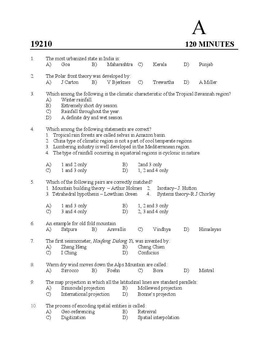
19210 120 MINUTES
1. The most urbanized state in India is:
A) Goa B) Maharashtra C) Kerala D) Punjab
2. The Polar front theory was developed by:
A) J Carton B) V Bjerknes C) Trewartha D) A Miller
3. Which among the following is the climatic characteristic of the Tropical Savannah region?
A) Winter rainfall.
B) Extremely short dry season.
C) Rainfall throughout the year.
D) A definite dry and wet season.
4. Which among the following statements are correct?
1. Tropical rain forests are called selvas in Amazon basin.
2. China type of climatic region is not a part of cool temperate regions.
3. Lumbering industry is well developed in the Mediterranean region.
4. The type of rainfall occurring in equatorial regions is cyclonic in nature.
A) 1 and 2 only B) 2and 3 only
C) 1 and 3 only D) 1, 2 and 4 only
5. Which of the following pairs are correctly matched?
1. Mountain building theory – Arthur Holmes 2. Isostacy– J. Hutton
3. Tetrahedral hypothesis – Lowthian Green 4. Systems theory–R J Chorley
A) 1 and 3 only B) 1, 2 and 3 only
C) 3 and 4 only D) 2, 3 and 4 only
6. An example for old fold mountain
A) Satpura B) Aravallis C) Vindhya D) Himalayas
7. The first seismometer, Houfeng Didong Yi, was invented by:
A) Zhang Heng B) Chang Chien
C) I Ching D) Confucius
8. Warm dry wind moves down the Alps Mountain are called:
A) Sirrocco B) Foehn C) Bora D) Mistral
9. The map projection in which all the latitudinal lines are standard parallels:
A) Sinusoidal projection B) Molleweid projection
C) International projection D) Bonne’s projecton
10. The process of encoding spatial entities is called:
A) Geo-referencing B) Retreival
C) Digitization D) Spatial interpolation
Page 2
A) Plato B) Aristotle C) Ptolemy D) Eratosthenes
12. The type of remote sensing sensor using a highly focused beam of light:
A) Sonar
B) Lidar
C) Side Looking Radar
D) Ground Penetrating Radar
13. The correct sequence of the following type of forests in India in descending order of their
areal coverage is:
A) Tropical thorn, Tropical dry deciduous, Tropical moist deciduous, Subtropical pine
B) Tropical dry deciduous, Tropical thorn, Tropical moist deciduous, Subtropical pine
C) Tropical thorn, Tropical dry deciduous, Subtropical pine, Tropical moist deciduous
D) Tropical dry deciduous, Tropical moist deciduous, Tropical thorn, Subtropical pine
14. Which is NOT an application of IRNSS among the following?
A) Vehicle tracking B) Precise Timing
C) Groundwater detection D) Disaster management
15. Multiple nuclei model was developed by:
A) Jefferson B) Mackinder C) Myrdal D) Ullman and Harris
16. The river in which the highest tidal bore is occurred in India:
A) Brahmaputra B) Godavari
C) Hoogly D) Damodar
17. The river which supplies fresh water to the Pichavaram mangrove system:
A) Cauveri B) Godavari C) Krishna D) Narmada
18. The difference between the mean temperatures in the hottest month and the coldest month is:
A) Annual range of temperature
B) Mean annual range of temperature
C) Diurnal range of temperature
D) Mean monthly temperature
19. Among the following which is not a native to India:
A) Rice B) Banana C) Maize D) Tea
20. Scattering occur to the electromagnetic radiation due to presence of particles much smaller
than the wave length of the radiation is:
A) Rayleigh scattering B) Mie scattering
C) Non selective scattering D) Selective scattering
21. The first isotherm map was developed by:
A) Aristotle B) Avicenna
C) Trewartha D) Alexander Von Humbold
2
Page 3
1. Sea floor spreading – Hess 2. Pediplanation – Hack
3. Binary Star hypothesis – Littleton 4. Subsidence theory – Murray
A) 1 and 3 only B) 1, 2 and 3 only
C) 3 and 4 only D) 2, 3 and 4 only
23. Beaufort scale is used for the measurement of:
A) Wind direction B) Intensity of earthquakes
C) Wind speed D) Speed of ocean current
24. Assertion (A): Ocean currents flowing from the equator towards north poles deflect to their
right.
Reason (R): The Coriolis force deflects the general direction of ocean currents.
A) A and R are true and R is the correct explanation of A.
B) A and R are true but R is not the correct explanation of A.
C) A is true but R is false.
D) A is false but R is true.
25. The coast associated with submergence of estuaries:
A) Dalmation coast B) Ria coast
C) Haff coast D) Fiord coast
26. Assertion (A): Normally temperature decreases with increase in height from the earth surface.
Reason (R): There is more moisture in the upper atmosphere.
A) A and R are true and R is the correct explanation of A.
B) A and R are true but R is not the correct explanation of A.
C) A is true but R is false.
D) A is false but R is true.
27. Assertion (A): The number of people migrating from one place to another decreases with the
increase in distance.
Reason (R) : Migration of population results in the development of large urban centres.
A) A and R are true and R is the correct explanation of A.
B) A and R are true but R is not the correct explanation of A.
C) A is true but R is false.
D) A is false but R is true.
28. Assertion (A): Frost action is one of the most important chemical weathering process.
Reason (R) : Chemical weathering affects various types of sedimentary and metamorphic
rocks.
A) A and R are true and R is the correct explanation of A.
B) A and R are true but R is not the correct explanation of A.
C) A is true but R is false.
D) A is false but R is true.
3
Page 4
A) Agulhas current B) Gulf stream
C) Humboldt current D) Kuroshio current
30. Choose the CORRECT sequence of Misra’s theoretical stages of Rural – Urban process
A) Agrural, Agurban, Indrurban, Indurban.
B) Agrural, Indrurban, Agurban,Indurban.
C) Agrural, Agurban, Indurban, Indrurban
D) Agrural, Indurban, Indrurban, Agurban.
31. The largest producer and exporter of coffee in the world:
A) India B) Malaysia C) Australia D) Brazil
32. Bikini Atoll is located at :
A) Lakshadweep Islands B) Andaman and Nicobar Islands
C) Marshall Islands D) Tuvalu Island
33. Benioff zones are related to:
A) Oceanic – Oceanic convergence
B) Oceanic – Continental convergence
C) Continent – Continental convergence
D) Divergence of lithospheric plates
34. The following are the climatic regions in India as per Koeppen’s classification. Identify the
correct sequence of them from south to north:
1. Amw 2. Cwg 3. AS 4. E
A) 2, 4, 3, 1 B) 3, 1, 2, 4 C) 3, 4, 2, 1 D) 2, 1, 3, 4
35. Among the following which is a mixture of rock fragments ranging from boulder to clay:
A) Outwash Plain B) Drumlin
C) Moraine D) Glacial Till
36. The agricultural region is:
A) Homogenous region B) Natural region
C) Functional region D) Nodal region
37. Which of the following three rivers of peninsular India have Amarkantak as their source?
A) Chambal, Mahanadi, Cauvery
B) Son, Mahanadi, Narmada
C) Mahanadi, Krishna, Weinganga
D) Betwa, Luni, Mahanadi
38. The ancient town Takshasila was located between :
A) Ravi and Beas B) Chenab and Ravi
C) Jhelum and Chenab D) Indus and Jhelum
39. The bars which are parallel to the coast but are not attached to land:
A) Bayhead bar B) Onshore bar C) Spit D) Offshore bar
4
Page 5
A) Valley winds B) Geostrophic winds
C) Katabatic winds D) Air currents
41. The map projection suitable to show global wind directions:
A) Sinusoidal Projection B) Molleweid’s projection
C) Mercator Projection D) Zenithal Globular projection
42. Among the following which is chemical weathering:
A) Exfoliation B) Spheroidal weathering
C) Shattering D) Granular disintegration
43. What is the time in Bangladesh (900 E) when it is noon in London?
A) 6 AM B) 7 PM C) 6 PM D) 7 AM
44. Match list I (Climatic region) with list II (Urban centres)
List I (Climatic regions) List II (Urban centres)
a. Tropical savanna 1. Rome
b. Mediterranean 2. Manchester
c. Equatorial region 3. Lagos
d. British type region 4. Guyaquil
A) a-4, b-3, c-2, d-1 B) a-2, b-4, c-3, d-1
C) a-3, b-1, c-4, d-2 D) a-2, b-1, c-4, d-3
45. Choose the correct pair:
A) Alluvial soil – Intrazonal soil B) Chernozem soil – zonal soil
C) Mountain soil – Inter zonal soil D) Brown soil – Azonal soil
46. The strait forms the main shipping channel between the Indian ocean and the Pacific ocean:
A) Strait of Gibraltar
B) Strait of Dover
C) Bass strait
D) Strait of Malacca
47. Which of the following is/ are true about El Nino?
1. El Nino is characterized by unusually warm surface temperature in the equatorial
Pacific Ocean
2. El Nino occurs very rarely only
3. Typical El Niño effects are likely to develop over North America during the
upcoming summer season.
4. During an El Nino year, winter temperatures are warmer than normal in the Southeast
and cooler than normal in the Northwest.
A) 1 only B) 1, 3 and 4 only C) 1 and 2 only D) 1 and 4 only
5
Page 6
A) Santhali B) Garo C) Khasi D) Pnar
49. A multipurpose project in India built in joint venture of India and Nepal:
A) Damodar Valley Project B) Kosi Multipurpose Project
C) Narmada Valley Project D) Hirakud Project
50. National Remote Sensing Centre is located in:
A) Ahmedabad B) Dehradun C) New Delhi D) Hyderabad
51. The concept of Spread and Backwash Effect was developed by:
A) G Frank B) Gunnar Myrdal
C) Harrold Damor D) Boudeville
52. Which is NOT a form of condensation among the following?
A) Fog B) Dew C) Hailstone D) Cloud
53. The cyclones developed on which of the following fronts provide widespread rainfall for an
area extending from the eastern part of North America to the northwestern part of Europe:
A) Atlantic polar front B) Atlantic – Arctic front
C) Pacific – Arctic front D) Mediterranean front
54. Consider the following urban agglomerations of Kerala.
1. Kozhikode 2. Kottayam 3.Cherthala 4.Kollam
The correct sequence in the ascending order of their population is:
A) 4, 3, 2 and 1 B) 2, 4, 3 and 1
C) 3, 2, 4 and 1 D) 2, 3, 4 and 1
55. The steel plant in India established with the technical and finanacial support of Germany:
A) Ranchi steel plant B) Durgapur steel plant
C) Rourkela steel plant D) Salem steel plant
56. The provenance of River Brahmaputra is :
A) Angsi Glacier B) Kailas Range
C) Manasarovar Lake D) Gaumukh
57. The scale of the Survey of India topographic map with the number 48/P/9 NW is:
A) 1 : 2,50,000 B) 1 : 25,000 C) 1 : 50,000 D) 1 : 20,000
58. The watershed between India and Myanmar is formed by:
A) The Jaintia Hills B) The Shivalik Hills
C) The Naga Hills D) The Lushai Hills
59. The coast along which Okhotsk current flows:
A) Coast of Kamchatka Peninsula
B) Cost of Mexico
C) Canadian coast
D) Alaska coast
6
Page 7
A) Cultivation of horticultural and cereal crops
B) Cultivation of cash crops and food crops
C) Cultivation of two or three crops in the same field
D) Rearing of animals and cultivation of crops together
61. Choose the correct sequence of demographic transition:
1. High birth rate with high death rate.
2. Low birth rate with low death rate.
3. High birth rate with low death rate.
A) 1, 2 and 3 B) 2, 1 and 3 C) 1, 3 and 2 D) 3, 2 and 1
62. Match List I with List II and select the correct answer using the codes given below the lists.
List I List II
a. Limits to growth. 1. Karl Ritter
b. Agricultural classification 2. Schaeffer
c. Philosophy of “Unity in 3. Pecoci
Diversity”
d Exceptionalism in geography 4. Whittlesey
Codes
A) a-3, b-4, c-2, d-1 B) a-4, b-3, c-2, d-1
C) a-3, b-4, c-1, d-2 D) a-2, b-4, c-3, d-1
63. The process of the transfer of heat through the movement of a substance from one place to
another is known as :
A) Conduction B) Convection C) Radiation D) None of the above
64. The Grand Banks form an important fishing ground of the world, because of the:
A) Meeting of Brail current with Oyashio current
B) Meeting of Brail current with Benguela current
C) Meeting of Gulf stream with Labrador current
D) Meeting of North equatorial current with Canary current
65. The definition of “Urban Geography is nothing but city" “in” area and city “as” area was
given by:
A) Harold Carter B) L Dudley Stamp
C) M Chisolm D) E Hardward
66. The phenomenon of the abnormal size of sea water level under the influence of low pressure
system is called:
A) Tidal bore B) Storm surge C) Surf D) Seichels
67. The actual heights of places above the sea level are shown by:
A) Spot heights B) Contours C) Hachures D) Hill shading
7
Page 8
A) Kuwait B) Russia C) Iran D) Iraq
69. Which of the following has been the oldest remote sensing programme?
A) LANDSAT B) SPOT C) NOAA D) INSAT
70. An example for arcuate delta is:
A) Missisippi delta B) Deltas of Narmada and Tapi
C) Ganga delta D) Cauvery delta
71. The term ‘ecosystem’ was first used by:
A) A R Calpham B) F R Fosberg
C) H T Odum D) A G Transley
72. Isohalines are the isopleths of :
A) Hail B) Ocean temperature
C) Rainfall D) Salinity
73. The first Five Year Plan in India was launched in:
A) 1951 B) 1948 C) 1956 D) 1950
74. Isotim refers to:
A) Connecting points of intersection
B) Connecting places having same distance from major markets.
C) Connecting points of equal transport cost
D) Connecting points having equal market facilities
75. Who introduced the term ‘Chorology’ in geography which was popularized by Richthofen?
A) Aristotle B) Hettner C) Strabo D) Hartshorne
76. Identify the type of volcanism which caused the building up of lava plateau
A) Hawaiian B) Icelandic C) Strombolian D) Pelean
77. Match list I (Books) with list II (Author) and choose the correct answer from the code below
List I (books List II (Author)
a. Anthropogeography 1. Hartshrone
b. Economic Determinism 2. Strabo
c. Aerial differentiation 3. Ratzel
d. Historica Memoir 4. Anuchin
A) a-1, b-3, c-2, d-4 B) a-4 ,b-3, c-1,d-2
C) a-2, b-3, c-1, d-4 D) a-3, b-4, c-1, d-2
78. The concept of Peneplanation was suggested by:
A) King B) Penck C) Hack D) W M Davis
8
Page 9
A) Moscow with Beijing
B) Moscow with Irkutsk
C) Moscow with Vladivostock
D) Moscow with Vladimir
80. Which is an outlier of the India plateau?
A) Aravallis B) Rajmahal Hills
C) Hazaribagh plateau D) Shillong plateau
81. The state in India where Kul irrigation is practiced:
A) Tamilnadu B) Himachal Pradesh
C) Odisha D) Rajasthan
82. Which is a Ramsar site in Kerala?
A) Ashtamudi Lake B) Periyar Lake
C) Pookode Lake D) Vellayani Lake
83. The state in India which has the most suitable climatic conditions for the cultivation of large
variety of orchids:
A) Maharashtra B) Karnataka
C) Kerala D) Arunachal Pradesh
84. An urban centre having ten lakh or more population is classified as:
A) City B) Conurbation C) Metropolis D) Megapolis
85. The temperate grasslands in Australia is called:
A) Steppe B) Veldt C) Campos D) Downs
86. What does 5 mm on a map made in a scale of 1:50,000 represent on the ground?
A) 25 Metres B) 250 Metres
C) 25 Centimetres D) 250 Centimetres
87. In Von Thunen’s theory the key variable in the agricultural location decision is :
A) Labour cost B) Value of agglomeration benefits
C) Irrigation cost D) Transportation cost
88. The focus of the Green Revolution was :
A) Improving crop yields in commercial agribusiness corporations
B) Reducing starvation in less-developed countries
C) Inventing new forms of food to add variety to the human diet
D) Saving undeveloped land from urban sprawl
89. Among the following which is a planned urban center in India?
A) Gandhinagar B) Agra C) Kanpur D) Shimla
90. The soil that contain considerable amount of soluble salts as well as organic matter and found
distributed in Kottayam and Alappuzha districts is:
A) Marshy soil B) Alkaline soil C) Saline soil D) Peaty soil
9
Page 10
standard deviation method is :
A) Nelson B) Harris C) Aurousseau D) Berry
92. Among the following map projections, which is more suitable for the representation of areas
of entire world over globe?
A) Gnomonic projection B) Sanson - Flamsteed’s projection
C) Mollweide’s projection D) Conical projection with two standard parallels
93. Among the following which is NOT a characteristics of CBD:
A) A CBD is characterized by tallest buildings
B) Maximum Accessibility
C) Concentration of residential population
D) CBD is somewhat a vague area with no definite boundaries
94. The element of an aerial photograph make its stereoscopic vision possible is:
A) Overlap B) Sidelap C) Fudicial point D) Texture
95. Among the following which is a primitive tribe in Saudi Arabia?
A) Masaiahs B) Bushmen C) Bedouins D) Arrente
96. The law of distance decay was introduced by:
A) E G Ravenstein B) F. Ratzel
C) Zelinsky D) Murray
97. The volcanoe known as the light house of the Mediterranean Sea:
A) Mt. Cleveland B) Mt. Stromboli
C) Mt. Erebus D) Mt. Yasur
98. The ‘Growth pole theory” was developed by:
A) Harris B) Perroux C) Myrdal D) Smailes
99. The population size for class I town in India as per Census 2011 is:
A) 10000 to 29999 B) 50000 to 99999
C) More than 1,00,000 D) More than10,00,000
100. Which of the following states share land frontier with China?
1. Arunachal Pradesh 2. West Bengal 3. Assam 4. Sikkim
A) 1, 2 and 4 B) 1, 2 and 3 C) 1, 2, 3 and 4 D) 1 and 4
101. Who first used the term ‘Umland’?
A) R L Singh B) R E Dickinson
C) Ander Allix D) Griffith Taylor
102. In India, according to state census 2011 the highest number of total population is in the state
of:
A) Tamilnadu B) West Bengal C) Maharashtra D) Uttar Pradesh
10
Page 11
A) Cartosat 2 B) HysIS C) Scatsat D) Risat
104. In which of the following states the Union Territory of Puducherry has its regions?
1. Tamilnadu 2. Kerala 3. Andhra Pradesh 4. Karnataka
A) 1, 2 and 3 B) 1 only C) 1, 2, 3 and 4 D) 2 and 3
105. Which among the following is NOT a land locked country?
A) Paraguay B) Bhutan C) Afghanistan D) Brazil
106. Which of the following are Tiger Reserves in India?
1. Bhitarkanika 2. Manas 3. Palamu 4. Buxa
A) 2, 3 and 4 B) 1, 3 and 4 C) 1, 2, and 4 D) 1, 2, 3 and 4
107. The largest producer of uranium in the world is:
A) India B) Kazakhstan C) Chile D) Malaysia
108. ‘Notogea’ refers to:
A) Supercontinent B) A marine feature
C) A Zoogeographical realm D) A fossil
109. Which among the following is a hot wind?
A) Mistral B) Bora C) Blizzard D) Khamsin
110. Spatial interpolation refers to:
A) The process of establishing values for areas outside the boundary
B) The process of establishing values for areas between an existing set of discrete
observations.
C) The process of establishing a statistical relationship between two spatially correlated
values.
D) The process of modeling a spatial pattern from a set of one or more data layers.
111. The magazine which became the mouth piece of radicalist geographers:
A) The Antipode
B) Annals of Geographers
C) Scottish geographical Journal
D) Applied Geographer
112. The geological period in which the formation of coal occurred in the earth:
A) Cretaceous period B) Pleistocene period
C) Carboniferous period D) Tertiary period
113. The ‘Comparative Cost Analysis’ theory was developed by:
A) Ricardo B) Weber C) McCarty D) Krugman
114. The spatial resolution of Cartosat -2 PAN image is:
A) 2 Metre B) Less than 1 Metre
C) 3 Metre D) 12 Metre
11
Page 12
A) The development of positivist approach in geography
B) The opposition to radicalist movement in geography
C) Dissatisfaction with the quantitative revolution
D) Opposition to the ecological approach
116. A system of mountains and hills having several ridges, peaks and valleys:
A) Mountain group B) Mountain range
C) Mountain system D) Cordillera
117. The concept of “Uniform density with varying thickness” was advanced by:
A) A H Hess B) Pratt C) Airy D) Dutton
118. Olive – Citrus – Vine trio is associated with:
A) Truck farming B) Mediterranean agriculture
C) Floriculture D) Horticulture
119. Nazca plate located at:
A) West of South America B) East of South America
C) South of South America D) North of South America
120. The stream which flows opposite to the direction of the original consequent stream:
A) Subsequent stream B) Insequent stream
C) Obsequent stream D) Resequent stream
****************
12
Document Details
| Board / Org | Kerala Exams |
| Exam | Kerala SET |
| Type | Question Paper |
| Pages | 12 |
| Updated | 23 Oct 2026 |