Kerala SET 2018 Jul Question Paper Geology
Finished viewing? Save it for later —
Download Kerala SET 2018 Jul Question Paper Geology (PDF · 11 pages)About Kerala SET 2018 Jul Question Paper Geology
Kerala SET 2018 Jul Question Paper Geology is available here for free download. Published by Kerala Exams for Kerala SET, this question paper can be viewed online or downloaded as a PDF (11 pages). Candidates preparing for Kerala SET can use Kerala SET 2018 Jul Question Paper Geology to understand the exam pattern, the type of questions asked, and the overall difficulty level.
Frequently Asked Questions
How can I download Kerala SET 2018 Jul Question Paper Geology?
Open this page and click the Download button to save Kerala SET 2018 Jul Question Paper Geology as a PDF. It is completely free on AglaSem Docs.
Is Kerala SET 2018 Jul Question Paper Geology free to download?
Yes. Kerala SET 2018 Jul Question Paper Geology can be viewed online and downloaded as a PDF free of cost on AglaSem Docs.
How many pages does Kerala SET 2018 Jul Question Paper Geology have?
Kerala SET 2018 Jul Question Paper Geology contains 11 pages, which you can read online or download together as a single PDF.
Where can I find more Kerala SET study material?
You can find more Kerala SET question papers, sample papers, syllabus, and answer keys on AglaSem Docs.
Kerala SET 2018 Jul Question Paper Geology – Text
Read the full text of this question paper below — useful to quickly search, copy and reference the content online without downloading the PDF.
📄 View text version (11 pages)
Page 1
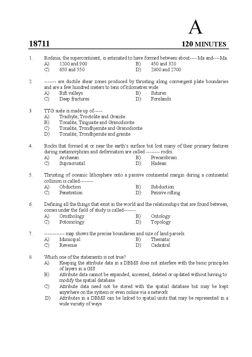
18711 120 MINUTES
1. Rodinia, the supercontinent, is estimated to have formed between about---- Ma and----Ma.
A) 1200 and 900 B) 450 and 320
C) 650 and 550 D) 2800 and 2700
2. ------- are ductile shear zones produced by thrusting along convergent plate boundaries
and are a few hundred meters to tens of kilometres wide.
A) Rift valleys B) Sutures
C) Deep fractures D) Forelands
3. TTG suite is made up of-----.
A) Trachyte, Troctolite and Granite
B) Tonalite, Tinguaite and Granodiorite
C) Tonalite, Trondhjemite and Granodiorite
D) Tonalite, Trondhjemite and granite
4. Rocks that formed at or near the earth’s surface but lost many of their primary features
during metamorphism and deformation are called -------- rocks.
A) Archaean B) Precambrian
C) Supracrustal D) Hadean
5. Thrusting of oceanic lithosphere onto a passive continental margin during a continental
collision is called--------
A) Obduction B) Subduction
C) Penetration D) Passive rifting
6. Defining all the things that exist in the world and the relationships that are found between,
comes under the field of study is called-------.
A) Ornithology B) Ontology
C) Potomology D) Topology
7. ------------ map shows the precise boundaries and size of land parcels.
A) Municipal B) Thematic
C) Revenue D) Cadastral
8. Which one of the statements is not true?
A) Keeping the attribute data in a DBMS does not interfere with the basic principles
of layers in a GIS
B) Attribute data cannot be expanded, accessed, deleted or updated without having to
modify the spatial database
C) Attribute data need not be stored with the spatial database but may be kept
anywhere on the system or even online via a network
D) Attributes in a DBMS can be linked to spatial units that may be represented in a
wide variety of ways
Page 2
A) Data structure B) Data record
C) Database D) Data analysis model
10. Irregular variations or error, usually short range that cannot be easily explained or
associated with major mapped features or processes:
A) Nominal data B) Nugget C) Noise D) Node
11. Which one is a pathfinder element for copper-zinc-lead-silver and complex sulphide
deposits?
A) Manganese B) Molybdenum
C) Arsenic D) Mercury
12. Choose the correct match:
A) Muscovite- Metallic bond B) Corundum-Vander Waal’s bond
C) Pyrite- Ionic bond D) Hydrogen-Covalent bond
13. Choose the correct match:
A) Almandine-Fe₃Cr₂(Sio₄)₃ B) Grossular-Ca₃Fe₂(SiO₄)₃
C) Andradite- Ca₃Al₂(SiO₄)₃ D) Pyrope-Mg₃Al₂(SiO₄)₃
14. Compounds of frozen water that contain gas molecules:
A) Permafrost B) Shale Gas
C) Gas Hydrates D) Coal Bed Methane.
15. The textural parameters of unconsolidated sediment that may affect porosity and
permeability is/are:
A) Grain shape B) Grain size C) Sorting D) All the above
16. Which is not true about coal mining?
A) Contour mining is carried out in plane topography
B) Room and pillar mining is a type of open stopping in near horizontal strata
C) Opencast mining is also referred to as surface mining
D) High wall mining is a remotely controlled mining method.
17. Which one among the following is a major coal producing country?
A) Nigeria B) Germany C) Brazil D) Japan
18. High Field Strength Elements (HFSE) are typically found concentrated in------
A) Metamorphic Rocks B) Early Magmatic deposits
C) Pegmatites D) Stratabound deposits
19. The depth in the Ocean where Calcium Carbonate begins to dissolve -----
A) Homocline B) Lysocline C) Thermocline D) Pynocline
20. Which is not true about hot spot?
A) They are locations where hot upwelling molten rocks are produced
B) Forms chains of volcanoes on the lithospheric plates as a function of time
C) They appear to move along with the overlying moving lithospheric plate.
D) Hawaiian Islands are examples of hot spots.
2
Page 3
A) Peridotite B) Gabbro C) Diorite D) Granite
22. Viola calaminaria is an indicator plant for --------- prospecting.
A) Fe B) Zn C) Cr D) Mn
23. Wustite, a mineral of composition FeO, is thought to be common in the -------of the earth.
A) Lower crust B) Lower mantle
C) Upper mantle D) Outer core
24. Choose the mismatch:
A) Nebular hypothesis-Immanuel Kant
B) Planetesimal Hypothesis -Chamberlin
C) Tidal Hypothesis-Harold Jeffrey
D) Cloud Hypothesis - Urey
25. Find the statement which is not correct
A) The region from the 410-km to the 660 km discontinuity is called the transition
zone
B) Asthenosphere readily deforms by creep
C) Low Velocity Zone (LVZ) occurs at the top of the asthenosphere
D) The upper mantle consists of the middle part of the lithosphere and the lower part
of the asthenosphere
26. 88% of the Earth’s heat is lost from the ---------
A) Upper crust B) Lower crust
C) Mantle D) Lithosphere
27. The temperature at which thermal remnant magnetization is acquired (Curie temp) in
magnetic minerals (Fe-Ti oxides) lies between ------°C and----°C
A) 500 and 600 B) 400 and 500
C) 600 and 700 D) 350 and 450
28. Magnetic surveys are useful for locating ---------------- deposits.
A) Salt dome B) Barite
C) Pyrrhotite-rich sulphide D) Graphite
29. Which one of the following is a gas giant planet?
A) Neptune B) Jupiter C) Pluto D) Uranus
30. Which is the correct sequence as per increasing density of rocks?
A) Limestone-Sandstone-Rhyolite-Shale
B) Shale-Sandstone-Quartzite-Limestone
C) Quartzite-Shale-Limestone-Sandstone
D) Sandstone-Shale-Limestone-Quartzite
31. The Tharsis bulge is the dominant structure on the surface of----------
A) Moon B) Saturn C) Mars D) Venus
3
Page 4
A) Comet B) Satellite C) Asteroid D) Meteorite
33. The Assam Himalayas is the portion of the Himalayas lying between the rivers--------
A) Indus and Ganges B) Tista and Brahmaputra
C) Ganges and Brahmaputra D) Kali and Tista.
34. Choose the correct match:
A) Beryl - Be Al₂O₄ B) Corundum - SnO₂
C) Cerussite - PbSO₄ D) Spinel - MgAl₂O₄
35. Examine the statements and find which one is true.
A) The birefringence of quartz is 0.009
B) Standard thin sections of minerals and rocks have a thickness of 0.03cm
C) In uniaxial minerals the prismatic sections are isotropic
D) Garnet sections have very low relief.
36. Which one of the following is correctly matched?
A) Three four fold axis of symmetry - Isometric system
B) One three fold or one six fold axis of symmetry - Trigonal system
C) Four two fold axis of symmetry - Orthorhombic system
D) Two four fold axis of symmetry - Tetragonal system
37. Penetration twin is common in --------- and --------.
A) Calcite and Cassiterite B) Fluorite and Pyrite
C) Rutile and Zircon D) Albite and Orthoclase
38. Which of the following is not correct?
A) Spherical projection is analogous to a globe
B) Stereographic projection is the best for determining the symmetry of crystals
C) For studying crystals lower hemisphere stereographic projection is used
D) Gnomonic projection is superior for making crystal drawings and graphical
determination of axial ratios
39. Embankments constructed or enlarged parallel to a river channel to prevent flooding are
called ------
A) Weirs B) Levees C) Fills D) Groins
40. ‘The angle between equivalent faces of crystals of the same substance measured at the
same temperature are constant’ –Who stated this?
A) Donnay B) Harkar C) Miller D) Steno
41. Which one of the following in the crust of the earth is considered as a minor element?
A) Mn B) Ni C) Ca D) Cr
42. The mode of occurrence of Kimberlites:
A) Dykes B) Sills
C) Volcanic pipes D) All the above
4
Page 5
A) Devitrification B) Diagenesis
C) Metamorphism D) Isomorphism
44. Among the following which one is not a normative mineral in CIPW norm?
A) Leucite B) Biotite C) Haematite D) Corundum
45. Many carbonatites are enriched in--------
A) Nb B) Rb C) U D) V
46. -------- are ultramafic lavas confined to Archaean greenstone belts.
A) Ophiolites B) Picrites C) Komatiites D) Anorthosites
47. When three phases coexist in a one-component system, the system is said to be ------.
A) Bivariant B) Univariant C) Monovariant D) Invariant
48. The boundaries of the time units in years are given below. Find the one which is not
correct.
A) Permian - Triassic - 325Ma B) Cretaceous-Tertiary - 65Ma
C) Archaean- Proterozoic – 2500Ma D) Cambrian- Proterozoic – 540Ma
49. Hiatus is the duration of -------------in stratigraphic record.
A) Period of break in deposition
B) Period of erosion
C) Period of erosion or non-deposition or both
D) Period of erosion or deposition
50. Isua in southwest Greenland is well known for the earliest known-------on the earth.
A) Reptilian fossils B) Sediments
C) Plant fossils D) Igneous rocks.
51. Which of the following is not true about Banded Iron Formations (BIF)?
A) Most BIF are metamorphosed
B) They were most abundant in Archaean and Palaeoproterozoic
C) They occur in rocks as young as 0.8Ma
D) Most of them are thought to have formed on cratons or passive margins in shallow
marine environments.
52. Which one is not recognised as a period of mass extinction?
A) Late Permian B) Late Silurian
C) Late Triassic D) Late Ordovician
53. In Ramsay’s classification of folds, which class has parallel isogons?
A) Class1 B B) Class 2 C) Class 3 D) Class 1 C
54. An isolated allochthonous unit overlying a tectonic surface surrounded in map pattern by
tectonically lower rocks:
A) Klippe B) Fenster
C) Tectonic window D) Nappe
5
Page 6
A) Depth B) Temperature C) Salinity D) Speed
56. Mullions and rodding are ----------- developed in strongly metamorphosed rocks.
A) Lineations B) Foliations
C) Strike joints D) Lineaments
57. Which of the following elements were suspected to be present during the Big Bang?
A) H₂, He, Li B) O₂,O₃, H₂ C) H₂, N, Li D) He, O₂, H₂
58. A Stream whose course is controlled by the form and slope of the existing land surface:
A) Resequent stream B) Consequent stream
C) Obsequent stream D) Subsequent stream
59. Biscuit –board topography is characteristic of ---------- landscape.
A) Fluvial B) Aeolian C) Glacial D) Volcanic
60. Match the following and choose the correct answer
I II
a) Red sea i) Transcurrent fault
b) Dead sea ii) Normal fault
c) Krakatoa iii) Rift valley
d) Lake Tanganyika iv) Volcano
A) a-i, b-iii, c-iv, d-ii B) a-ii, b-i, c-iv, d-iii
C) a-iii, b-ii, c-i, d-iv D) a-ii, b-iii, c-iv, d-i
61. An island which is located on the Mid-Atlantic Ridge or close to it:
A) Hawaii B) Diego Garcia
C) Iceland D) Tasmania
62. In which of the following countries plateau basalts are found?
A) Colombia and India B) Sweden and India
C) Sri Lanka and Bangladesh D) Hungary and China
63. Majority of the trenches in the sea–floor have------
A) Small positive gravity anomalies B) Large negative gravity anomalies
C) No gravity anomalies D) Large positive gravity anomalies
64. Match the following and choose the answers from the codes given
I II
a) Argillaceous i) Biolithite
b) Limestone of organic origin ii) Rudite
c) Arenaceous sediment with feldspar iii) Marl
d) Rock with angular rock fragments iv) Arkose
A) a-iv, b-iii, c-ii, d-i B) a-iii, b-i, c-iv, d-ii
C) a-ii, b-iii, c-i, d-iv D) a-i, b-iv, c-ii, d-iii
6
Page 7
A) Pelagic B) Neritic C) Abyssal D) Bathyal
66. Rajmahal Hills are located in -------
A) Jharkhand B) Uttarakhand C) Odisha D) Maharashtra
67. The slowest type of mass wasting which takes place over a long period of time:
A) Slump B) Earthflow
C) NuesArdente D) Creep
68. Bentonites are almost composed of ---------
A) Feldspars and silica B) Montmorillonite and colloidal silica
C) Kaolinite and chlorite D) Illite and silica gel
69. Conglomerate with pebbles of sediment that originated within a depositional basin is
called -------- conglomerate.
A) Intrinsic B) Extra-formational
C) Intra-formational D) Inter-fluvial
70. In the Bouma Sequence current ripples and lamination are found in the -------part.
A) Lower B) Middle
C) Upper D) All the above
71. Which one of the following is not extinct?
A) Acanthoda B) Paradoxide C) Placoderma D) Nautilus
72. Lamellibranchia is a/an--------
A) Order B) Class C) Phylum D) Family
73. The Trilobites without Pygiduim are called---------
A) Isopygous B) Apygous
C) Micropygous D) Nonpygous
74. The primitive horse which lived in the Eocene Epoch:
A) Equus B) Hyracotherium
C) Miohippus D) Merychippus
75. Choose the correct Match:
A) Ambulacral canal - Venus B) Pallial sinus - Echinoid
C) Cephalon - Olenus D) Sutureline - Tetragraptus
76. Tourmaline comes under-----
A) Tectosilicates B) Inosilicates
C) Cyclosilicates D) Phyllosilicates
77. Fossil remains of primates are reported from the ----------
A) Gondwana sediments B) Vindhyan sediments
C) Siwalik sediments D) Kutch sediments
7
Page 8
A) Ammonites B) Dinosaurs
C) Belemnites D) All the above
79. A fold in which the axis plunges directly down the dip of the axial plane is called-------
fold.
A) Isoclinal B) Reclined
C) Similar D) Recumbent
80. In which type of aerial photograph the horizon is not seen?
A) High oblique B) Panorama
C) Low oblique D) Horizontal
81. The Indian Institute of Remote Sensing is located at-------
A) Hyderabad B) Dehra Dun
C) New Delhi D) Bangalore
82. The Eparchaean unconformity separates the--------
A) Archaean from the Proterozoic
B) The Precambrian from the Cambrian
C) The Cambrian from the Archaean
D) The Mesozoic from the Palaeozoic.
83. A fault that dips less than 10°and has a large net slip:
A) Thrust B) Reverse fault
C) Overthrust D) Upthrust
84. As per Sander’s (1948) nomenclature, the -------- direction is the direction of the fold axis.
A) a B) b C) c D) d
85. The typical copper sulphide mineral formed by supergene enrichment:
A) Chalcopyrite B) Covellite
C) Chalcocite D) Tetrahedrite
86. Name the Indian coast that has rocky broken belt with submerged border and rocky
islands and has moderate relief
A) Konkan coast B) Karnataka coast
C) Gujarat coast D) Kerala coast
87. Alfred Wegener, who gave the continental Drift hypothesis, was a----------
A) Geologist B) Geographer
C) Meteorologist D) Chemist
88. Which one of the following statements is not true?
A) Mercalli Scale measures intensity of earthquakes.
B) Richter scale measures the magnitude of earthquakes
C) Rossi- Forell scale has a range from 1 to 10
D) Modified Mercalli scale has a range from 1 to 8.
8
Page 9
A) Upper Jurassic B) Permian
C) Cretaceous D) Triassic
90. Which of the following is not true about red boles found between Deccan Lava flows?
A) Considered as marker horizons
B) Composed of pyroclasts
C) Consist of illite, plagioclase and quartz
D) Have basic composition.
91. Choose the correct match
A) Palaeogene period ---- Palaeocene, Eocene, Oligocene
B) Neogene Period ---- Miocene, Pliocene, Pleistocene
C) Quaternary period ---- Holocene, Pleistocene
D) Tertiary Period ---- Palaeocene, Eocene, Miocene
92. Which intrusive rock is common to Chengannur, Kalpatta, Munnar and Ambalavayal in
Kerala?
A) Gabbro B) Granite C) Syenite D) Anorthosite
93. Luni formation, Jaipur formation, Churu formation and Bikaner formation in Rajasthan
belong to --------- age.
A) Tertiary B) Triassic C) Cretaceous D) Quaternary
94. The Siwalik sediments have been deposited in -------- environments
A) Outwash plains B) Channel and flood plains
C) Lacustrine D) All the above
95. Which is major copper producing state In India?
A) Uttar Pradesh B) Telengana
C) Madhya Pradesh D) Maharashtra
96. Among the following rocks which gives the highest radioactive heat production in the
earth?
A) Dunite B) Granite
C) Alkali basalt D) Peridotite
97. In self-potential surveys for mineral exploration --------- is used.
A) Digital voltmeter B) Digital Ammeter
C) Gravimeter D) Geophone
98. In vertical electrical sounding the variation of --------with depth is used.
A) Density B) Resistivity
C) Current D) Porosity
99. On the basis of --------- three main classes of magnetic behaviour are distinguished.
A) Magnetic susceptibility B) Permeability
C) Polarity D) Gravity
9
Page 10
A) 0.7µm and 1.3 µm B) 1.2 µm and 1.4 µm
C) 3 µm and 14 µm D) 1.5 µm and 1.8 µm
101. The line traced on the ground directly beneath the aircraft during acquisition of aerial
photography is called-------
A) Nadir line B) Azimuth
C) Flight line D) None of the above
102. To measure the moisture content in bore holes---- are used.
A) Calibrated neutron logs B) Natural gammalogs
C) Resistivity logs D) Sonic logs
103. The principal source of fluoride in groundwater may be --------
A) Plagioclase B) Enstatite C) Hornblende D) Dolomite
104. Soil-water zone forms part of --------
A) Capillary Zone B) Intermediate Vadose
C) Zone of Saturation D) Zone of Aeration
105. Which of the following is not true about gravel packs surrounding the well screens?
A) Stabilizes the aquifer
B) Minimizes sand pumping
C) Permits use of a small screen slot with a minimum open area
D) Increases the effective radius and yield of the well
106. From animal wastes, the most important persistent pollutant that may reach the water
table is --------
A) Nitrate- nitrogen B) Calcium and Sodium
C) Phosphorous D) Bicarbonate
107. For the Ghyben- Herzberg relation the density of typical sea water is taken as----------
A) 1.100g/cm³ B) 1.50gm/cm³
C) 1.025gm/cm³ D) 1.050gm/cm³
108. Groundwater withdrawn at a rate exceeding recharge results in ------
A) Maximum Perennial Yield B) Mining yield
C) Overdraft D) Deferred perennial yield
109. Hirakud Dam constructed across the Mahanadi River is --------
A) A concrete gravity dam B) A masonry arch dam
C) An earth dam D) An arch dam.
110. Which of the following does not form part of the most ideal geological conditions for
excavation of tunnels in an area?
A) There should be only one rock type
B) The rock should be without faults or intrusions
C) The rock should be hard but not stiff
D) The rock should be impermeable.
10
Page 11
A) Low mobility grouting B) Clay grouting
C) Jet grouting D) Compensation grouting.
112. Find the mismatch from the metamorphic facies and diagnostic minerals assemblages.
A) Blueschist facies - Glaucophane
B) Greenschist facies - Albite-Tremolite
C) Granulite facies - Hornblende-Plagioclase
D) Zeolite facies - Laumontite
113. In Regional metamorphism, metamorphic heat may be transported by:
A) Conduction B) Conduction or advection
C) Advection D) Convection or advection
114. Fenitization is the formation of metasomatic rocks around -------intrusions.
A) Alkaline syenite B) Carbonatite
C) Kimberlite D) All the above
115. Ductile flow of rocks can occur by------
A) Dislocation creep
B) Granular flow and dislocation creep
C) Cataclastic flow
D) Granular flow, dislocation creep and diffusion creep
116. Choose the mismatch:
A) Diagenetic foliation - Slate B) Composite foliation - Mylonites
C) Gnessic foliation - Gneiss D) Crenulation cleavage - Schist
117. Tumbling mills are used in --------process of ore dressing.
A) Crushing B) Grinding
C) Jigging D) Screening
118. The Principle of Faunal Succession was stated by ------------
A) A.G.Werner B) Nicholaus Steno
C) William Smith D) Lehmann
119. The area covered in 49H/2 Survey of India topographic sheet will be shared among ------
number of 1:25,000 sheets.
A) 2 B) 4 C) 6 D) 8
120. Strike-Oriented ridges are characteristic of -------- dominated deltas.
A) River B) Tide C) Current D) Wave
*************************
11
Document Details
| Board / Org | Kerala Exams |
| Exam | Kerala SET |
| Type | Question Paper |
| Pages | 11 |
| Updated | 23 Oct 2026 |