Kerala SET 2018 Jul Question Paper Geography
Finished viewing? Save it for later —
Download Kerala SET 2018 Jul Question Paper Geography (PDF · 14 pages)About Kerala SET 2018 Jul Question Paper Geography
Kerala SET 2018 Jul Question Paper Geography is available here for free download. Published by Kerala Exams for Kerala SET, this question paper can be viewed online or downloaded as a PDF (14 pages). Candidates preparing for Kerala SET can use Kerala SET 2018 Jul Question Paper Geography to understand the exam pattern, the type of questions asked, and the overall difficulty level.
Frequently Asked Questions
How can I download Kerala SET 2018 Jul Question Paper Geography?
Open this page and click the Download button to save Kerala SET 2018 Jul Question Paper Geography as a PDF. It is completely free on AglaSem Docs.
Is Kerala SET 2018 Jul Question Paper Geography free to download?
Yes. Kerala SET 2018 Jul Question Paper Geography can be viewed online and downloaded as a PDF free of cost on AglaSem Docs.
How many pages does Kerala SET 2018 Jul Question Paper Geography have?
Kerala SET 2018 Jul Question Paper Geography contains 14 pages, which you can read online or download together as a single PDF.
Where can I find more Kerala SET study material?
You can find more Kerala SET question papers, sample papers, syllabus, and answer keys on AglaSem Docs.
Kerala SET 2018 Jul Question Paper Geography – Text
Read the full text of this question paper below — useful to quickly search, copy and reference the content online without downloading the PDF.
📄 View text version (14 pages)
Page 1
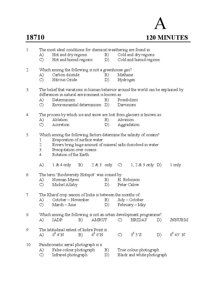
18710 120 MINUTES
1. The most ideal conditions for chemical weathering are found in:
A) Hot and dry regions B) Cold and dry regions
C) Hot and humid regions D) Cold and humid regions
2. Which among the following is not a greenhouse gas?
A) Carbon dioxide B) Methane
C) Nitrous Oxide D) Hydrogen
3. The belief that variations in human behavior around the world can be explained by
differences in natural environment is known as:
A) Determinism B) Possibilism
C) Environmental determinism D) Darvinism
4. The process by which ice and snow are lost from glaciers is known as:
A) Ablation B) Abrasion
C) Accretion D) Aggradation
5. Which among the following factors determine the salinity of oceans?
1. Evaporation of surface water
2. Rivers bring huge amount of mineral salts dissolved in water
3. Precipitation over oceans
4. Rotation of the Earth
A) 1 & 4 only B) 2 & 3 only C) 1, 2 & 3 only D) 1 only
6. The term ‘Biodiversity Hotspot’ was coined by:
A) Norman Myres B) H. Robinson
C) Michel Allaby D) Peter Calow
7. The Kharif crop season of India is between the months of:
A) October – November B) July – October
C) March – June D) February – May
8. Which among the following is not an urban development programme?
A) IADP B) AMRUT C) HRIDAY D) JNNURM
9. The latitudinal extent of Indira Point is:
A) 80 4’N B) 40 8’N C) 30 5’S D) 60 45’ N
10. Panchromatic aerial photograph is a:
A) False colour photograph B) True colour photograph
C) Infrared photograph D) Black and white photograph
Page 2
Match them correctly
Geographer Country
a. Carl Ritter 1. France
b. Vidal de la Blache 2. USA
c. Griffith Taylor 3. Germany
d. Ellen Churchill Semple 4. Australia
A) a-3, b-1, c-4, d-2 B) a-2, b-3, c-4, d-1
C) a-4, b-2, c-3, d-1 D) a-1, b-4, c-2, d-3
12. The view point that ‘man is responsible for his own nature’ is known as:
A) Pragmatism B) Positivism
C) Existentialism D) Idealism
13. The width of the area on the surface of the Earth which is imaged by a satellite
sensor is known as:
A) Nadir B) Zenith C) Swath D) Apogee
14. DBMS module in a GIS software helps in:
A) Conversion of analogue data to digital data
B) Analysis of point data
C) Organization and retrieval of data
D) Analysis of polygon data
15. The ocean current responsible for the parched climate of Kalahari and Namib Deserts is:
A) Labrador Current B) Gulf Stream
C) Benguela Current D) Canaries Current
16. Which among the following cities is popularly known as ‘Cottonopolis of India’?
A) Ahmadabad B) Coimbatore C) Surat D) Mumbai
17. The first Five Year Plan in India was between:
A) 1947-1952 B) 1951-1956 C) 1952-1957 D) 1961-1966
18. Which among the following is not an example of ‘Autotrophs’?
A) Banyan tree B) Mango tree C) Green algae D) Sambar Deer
19. Intensive subsistence farming is practiced in
A) Western USA & Canada B) Eastern Europe & Mexico
C) South & South-East Asia D) Australia & Newzealand
Answer the questions 20-23 based on the directions given below:
Following questions consist of two statements, one labeled Assertion (A) and the
other labeled Reason (R). Examine these two statements carefully and choose the
correct explanation from the codes given
2
Page 3
Reason (R) : In migration of female population is more in Kerala
A) A & R are true and R is the correct explanation of A
B) A & R are true and R is not the correct explanation of A
C) A is true but R is false
D) A is false but R is true
21. Assertion (A) : Friedrich Ratzel in his book ‘Anthropogeography’
highlighted that history, culture and gamut of life are
largely influenced by the physical environment
Reason (R) : Ratzel was a proponent of Determinism
A) A & R are true and R is the correct explanation of A
B) A & R are true and R is not the correct explanation of A
C) A is true but R is false
D) A is false but R is true
22. Assertion (A) : Himalayan Rivers are examples of Consequent Drainage
Reason (R) : Himalayan Rivers flow through gorges that have been
carved out by down cutting and side by side with
uplift of Himalayas
A) A & R are true and R is the correct explanation of A
B) A & R are true and R is not the correct explanation of A
C) A is true but R is false
D) A is false but R is true
23. Assertion (A) : Cirrostratus clouds generally produce halo
Reason (R) : Cirrostratus clouds have whitish veil of fibrous or smooth
appearance and they often cover whole sky
A) A & R are true and R is the correct explanation of A
B) A & R are true and R is not the correct explanation of A
C) A is true but R is false
D) A is false but R is true
24. A Rift Valley is found along:
A) Divergent plate boundaries B) Convergent plate boundaries
C) Transform plate boundaries D) Upper course of a river
25. The National Highway 66 connects:
A) Kanyakumari and Bengaluru B) Panvel and Kanyakumari
C) Kanyakumari and Chennai D) Mumbai and Pune
26. Which among the following years is referred to as a ‘Demographic Divide’ when
the whole country recorded a negative growth rate during the previous decade
A) 1931 B) 1961 C) 1911 D) 1921
3
Page 4
in them. Match them correctly.
SATELLITES SENSORS
a) LANDSAT -7 1. AWiFS
b) SPOT- 3 2. ETM+
c) RESOURCESAT -2 3. Geotone 1
d) Resurs DK-1 4. HRVIR
A) a-4, b-3, c-2, d-1 B) a-3, b-1, c-4, d-2
C) a-2, b-4, c-1, d-3 D) a-1, b-4, c-3, d-2
28. The type of analysis used in GIS to identify the area of interest around an entity or
set of entities is known as
A) Buffering B) Overlay C) Networking D) Querying
29. Which among the following statements are true with regard to trellis pattern of drainage?
1. Main stream is like the trunk of a tree and tributaries are like branches
2. Ridges are arranged around the margins of domes and the drainage
become curved
3. Streams flow on all sides like spokes of a wheel
4. Consequent, subsequent and obsequent streams take up a rectangular pattern
A) Only 4 is true B) 2 & 3 are true C) 1 & 2 are true D) 1 & 3 are true
30. Oozes are examples of:
A) Terrigenous deposits B) Pelagic deposits
C) Fluvial deposits D) Glacial deposits
31. A map shows the distribution of rice growing areas of India. To which of the
following approaches that this can be attributed to?
A) Systematic Approach B) Behavioral Approach
C) Environmental Approach D) Political Economy Approach
32. Which among the following is not a component of Green Revolution?
A) Intensive Agricultural Development Programme
B) High Yielding Varieties Programme
C) Command Area Development Programme
D) Organic Fertilizer Programme
33. Wavelength of near infrared spectrum of electromagnetic radiation is:
A) 07-1.3µm B) 0.4-0.7 µm C) 0.001-0.4 µm D) 1-10 mm
34. Four most populous countries in the world after China and India, are given below.
Arrange them in descending order
1. Pakistan 2. USA 3. Indonesia 4. Brazil
A) 1,3,4,2 B) 2,3,4,1 C) 4,2,1,3 D) 3,2,1,4
4
Page 5
India?
A) Resulted in increase in food grain production
B) Resulted in large scale farm mechanization
C) Brought about basic change in the attitude of farmers towards farming
D) Its impact could be seen throughout the country
36. Among the countries given below, which one has an expansive population pyramid?
A) USA B) Britain C) India D) Germany
37. The concept of Growth Pole was put forwarded by:
A) Griffith Taylor B) Peter Haggett
C) M.Chisholm D) Francois Perroux
38. Which among the following statements are true with regard to Rourkela Steel
Plant of Hindustan Steel Ltd?
1. Established with help of then West Germany
2. Hydroelectricity is obtained from Damodar Valley Project
3. Utilizes Chennai Port for import and export
4. Sundargargh and Keonjhar supplies iron ore to this plant
A) 1 & 2 are true B) 2 & 3 are true C) 2 & 4 are true D) 1 & 4 are true
39. Most densely populated district in Kerala as per 2011 Census is:
A) Malappuram B) Kozhikode
C) Ernakulam D) Thiruvananthapuram
40. A map projection which maintains the same scale in both directions along the
parallels and meridians when they intersect at right angles is called:
A) Homolographic Projection B) Orthomorphic Projection
C) Ortho Projection D) Stereoscopic Projection
41. The system of aerial photography which is an assembly of one vertical and two
oblique left and right photographs taken simultaneously is known as
A) Multi lens photography B) Trimetrogon Photography
C) Convergent Photography D) Strip Photography
Answer the questions 42- 44 based on the directions given below:
Following questions consist of two statements, one labeled Assertion (A) and the
other labeled Reason (R). Examine these two statements carefully and choose the
correct explanation from the codes given
42. Assertion (A) : Water appears as dark colour in a FCC
Reason (R) : Water absorbs most of the energy except in the blue–green
portion of the visible Spectrum
A) A & R are true and R is the correct explanation of A
B) A & R are true and R is not the correct explanation of A
C) A is true but R is false
D) A is false but R is true
5
Page 6
Reason (R) : Some of the factors affecting the soil reflectance are
moisture content, soil texture, presence of iron oxide and
organic matter
A) A & R are true and R is the correct explanation of A
B) A & R are true and R is not the correct explanation of A
C) A is true but R is false
D) A is false but R is true
44. Assertion (A) : Vegetation appears as green in FCC
Reason (R) : Vegetation reflects 40-50 % of infrared energy
A) A & R are true and R is the correct explanation of A
B) A & R are true and R is not the correct explanation of A
C) A is true but R is false
D) A is false but R is true
45. Which among the following is a warm current?
A) Labrador Current B) Benguela Current
C) Canary Current D) Gulf Stream
46. Which of the following landforms do the Guyots belong to?
A) Fluvial landform B) Submarine landform
C) Aeolian land form D) Karst landform
47. Lines joining places having equal transportation costs are called
A) Isohaline B) Isotims C) Isodopanes D) Isohytes
48. The term ‘Crude’ in Crude Birth Rate and Crude Death Rate refers to:
A) Birth rate and Death rate cannot be calculated correctly
B) They are calculated without regard to male female composition of the
Population
C) Infant mortality is calculated separately from the total death rate
D) Fertility rate is calculated separately from the whole birth rate
49. The theory that ‘Human population grows geometrically while the food supply
grows arithmetically’ is put forwarded by
A) Karl Marx B) David Ricardo
C) Thomas Malthus D) C.P. Lo
50. The concept of Distance Decay is associated with
A) Concentric Ring Model B) Central Place Model
C) Multiple Nuclei Model D) Gravity Model
51. Sector Theory of urban morphology was proposed by:
A) H. Hoyt & M. R. Davis B) E. L. Ullaman & C. D. Harris
C) E. W. Burgess D) W. J. Reilly
6
Page 7
cities which has merged together to form one single continuous urban area through
population growth and physical expansion?
A) Urban Sprawl B) Conurbation
C) Metropolitan City D) Cosmopolitan City
53. The country that shares longest land frontier with India is:
A) Bangladesh B) China C) Pakistan D) Nepal
54. As per the Census of India classification, a Class V town will have a population of:
A) 50,000-99,999 B) 5000-9999
C) 10,000-19,999 D) < 5000
55. Which among the following regions of Kerala has been identified as containing
deposits of gold?
A) Kannur-Thalasserry B) Nedunkandam-Devikulam
C) Wayanad-Nilambur D) Palakkad-Chitoor
56. Which among the given scale represent a cadastral map?
A) 1:50,000 B) 1:25,000 C) 1:100,000 D) 1:5000
57. Conservation of selected plants and animals in selected area outside their habitat
is known as:
A) In-situ Conservation
B) Ex-situ Conservation
C) Protected Area Conservation
D) Biodiversity Conservation
58. The actual time difference between Sourashtra and Arunachal Pradesh is about:
A) 2 hours B) 1 hour 40 minutes
C) 3 hours D) 5 hour 30 minutes
59. The technique of map representation using various symbols and letters is known as:
A) Choropleth Technique B) Isopleth Technique
C) Chorochromatic Technique D) ChoroschematicTeachnique
60. A Neat Line on a map is:
A) A line drawn around the border of the map
B) A line drawn around the legend
C) A line drawn around the scale bar
D) A line drawn around the direction symbol
61. Which among the following is not necessarily a component of a GIS?
A) Personal Computer B) Satellite Image
C) Population Data D) WiFi
7
Page 8
different temperature is in contact with one another is known as:
A) Conduction B) Advection
C) Convection D) Refraction
63. The following table gives the list of major biosphere reserves in India, its location
and major fauna found there. Arrange them in correct sequence:
Biosphere Reserve State Major Fauna
1. Nandadevi a. Assam I. Red Panda
2. Nokrek b. Madhya Pradesh II. Snow Leopard
3. Pachmarhi c. Meghalaya III. Golden Langur
4. Manas d. Uttaranchal IV. Giant Squirrel
A) 1-d-II, 2-c-I, 3-b-IV, 4-a-III B) 1-d-IV, 2-a-II, 3-c-I, 4-b-III
C) 1-c-III, 2-b-IV, 3-d-II, 4-a-I D) 1-a-IV, 2-d-I, 3-b-II, 4-c-III
64. The city popularly known as the ‘Manchester of South India’ is:
A) Salem B) Coimbatore C) Bengaluru D) Kochi
65. Following are some of the properties of Mercator’s Projection. Identify those
which are wrongly stated.
1. Latitudes are parallel to the equator, are straight lines and scale is true only
along the equator
2. Longitudes are straight line and are parallel to one another
3. Distance are correct along the equator and are same from latitude to latitude
4. Progressive increase of vertical and horizontal scale away from the equator
leads to exaggeration
A) 1, 2 & 3 are wrong B) Only 3 is wrong
C) 2 & 4 are wrong D) 1 & 4 wrong
66. What type of climate does the Moisture Index value is 100 or above 100 denotes
according to Thornthwait’s Climatic Classification
A) Humid B) Sub-Humid C) Semi-Arid D) Per-humid
67. Which among the following is not considered as a problem of Indian agriculture?
A) Predominance of food crops B) Lack of proper irrigation facilities
C) Fragmented landholdings D) Inadequacy of good quality seeds
68. What is the name of an elevated piece of land situated along the banks of Upper
Ganga-Yamuna Doab
A) Bhabar B) Bangar C) Tarai D) Bhur
8
Page 9
1. It is formed when relatively warm air mass moves into a region which is
comparatively colder
2. Generally common on sea coasts where there are no strong winds
3. Commonly found along the Grand Banks of Canada and Newfoundland
4. It may also occur over land when warm air blows over frozen or snow-covered
ground.
A) 1 & 2 are correct B) 2 & 4 are correct
C) Only 3 is correct D) 1, 2, 3 & 4 are correct
70. Manas National Park is located in:
A) Manipur B) Tripura C) Assam D) Karnataka
71. Following table shows major industrial regions of the world and major urban
centers in them. Correctly match them:
Industrial Region Urban Center
a. New Englad Region 1. Manchester
b. Prairies Region 2. Massachusetts
c. Lancashire Region 3. Dusseldorf
d. Rhine Region 4. Alberta
A) a-4, b-1, c-3, d-2 B) a-2, b-4, c-1, d-3
C) a-3, b-2, c-4, d-1 D) a-1, b-3, c-2, d-4
72. As per the Nine Fold Land use classification followed in India the land use class
‘Current Fallow’ indicates
A) All lands available for cultivation whether or not taken up for cultivation or
taken u for once but not cultivated currently
B) All lands which are taken up for cultivation but temporarily out of cultivation
for a period of less than a year but not more than 5 years
C) Comprises cropped area which are kept fallow during the current year
D) Land which cannot be brought under cultivation
73. Major peaks of Himalayas are listed below. Arrange them in west-east sequence
1. Mt. Everest 2. Mt. Namcha Barwa 3. Mt. Nanga Parbat 4. Mt. Kanchenchunga
A) 2, 4, 3, 1 B) 3, 1, 4, 2 C) 1, 3, 2, 4 D) 4, 2, 1, 3
74. What percentage of overlap of adjacent photographs is required to get a Stereo Vision?
A) 60% B) 10% C) 25% D) 45%
75. The orbital altitude of geostationary satellites would be around:
A) 36,000 km B) 3600 km C) 360 km D) 10,000 km
9
Page 10
A) Boundary of a forest area
B) A road passing through the forest area
C) Description about the forest area
D) Location of an office building in the forest area
77. Reasons for the predominance of tank irrigation in Peninsular India is given
below. Choose the correct ones.
1. Construction of canals and digging of wells is difficult because of undulating
relief and hard rocks.
2. Most of the rivers are seasonal and hence cannot supply water throughout the
year.
3. Lack of political will and red tapeism
4. Most of the tanks are natural and hence do not involve heavy costs for the
construction
A) 1 & 2 are correct B) 2, 3 & 4 are correct
C) 1 & 4 are correct D) 1, 2 & 4 are correct
78. Which among the following is not an open source GIS software?
A) QGIS B) GRASS
C) gvSIG D) AutoCAD MAP
79. Following table shows some authors and their books. Match them correctly
AUTHORS BOOKS
1. Perspectives On The Nature of
a. Von Thunen
Geography
2. Innovation Diffusion As A Spatial
b. L. D. Stamp
Process
c. Hartshone 3. Isolated State
4. The Land of Britain: Its Use And
d. Hagerstrand
Misuse
A) a-4, b-1, c-3, d-2 B) a-3, b-4, c-1, d-2
C) a-2, b-3, c-1, d-4 D) a-1, b-3, c-4, d-2
80. Shevroy Hills are located in:
A) Karnataka B) Tamil Nadu
C) Madhya Pradesh D) Orissa
81. As per Thornthwait’s Climatic Classification, majority of India belong to which
type of climate:
A) Humid B) Per-Humid C) Sub-Humid D) Semi-Arid
82. Most useful form of representation of scale on a map is:
A) RF B) Statement Scale
C) Graphical Scale D) No scale
10
Page 11
A) 24 B) 16 C) 20 D) 5
84. Name of the Indian navigation satellite system is:
A) IRS-1D B) GLONASS C) GALILEO D) IRNSS
85. Given below are the characteristics of ‘eye’ of a cyclone. Identify the correct ones.
1. Wind speed often reaches 200-300 kms
2. Calm area with light winds with clear or partly cloudy skies
3. Area of lowest pressure within the system
4. Warmer than surrounding areas
A) 1 & 3 only are correct B) 2 & 4 only are correct
C) 2, 3 & 4 only are correct D) Only 1 is correct
86. Plutonic rocks are:
A) Intrusive igneous rocks B) Extrusive igneous rocks
C) Sedimentary rocks D) Metamorphic rocks
87. The warm dry wind that blows on the eastern slopes of Rockies and often result
in sudden and drastic rise in temperature is
A) Bora B) Fohn C) Harmattan D) Chinook
88. The term ‘Human Ecology’ was coined by:
A) R. E. Dickinson B) Lucier Febvre
C) Harlan Barrows D) E. Huntington
89. The range electromagnetic radiation spectrum that a remote sensing sensor capable
of recording is known as:
A) Spatial Resolution B) Spectral Resolution
C) Radiometric Resolution D) Satellite Resolution
90. Boreal Biomes are found in:
A) Canada B) Tropical Africa
C) Antarctica D) South America
91. At what time of the day is the intensity of insolation maximum?
A) At noon B) One hour after noon
C) One hour after sun rise D) One hour before noon
92. Polar fronts usually occur around:
A) 600 N & S of the equator B) 77 ½0 N & S of the equator
C) At the Poles D) 450 N & S of the equator
93. Most widely spread forest type in India is:
A) Tropical Wet Evergreen B) Tropical Moist Deciduous
C) Tropical dry Deciduous D) Tropical Semi-Evergreen
94. Which type of soil is popularly known as ‘regur’?
A) Laterite soil B) Red soil C) Black soil D) Alluvial soil
11
Page 12
A) Andhra Pradesh B) Orissa
C) West Bengal D) Tamil Nadu
96. Following are some statements regarding supervised image classification of digital
satellite images. Identify the wrong statements
1. The image processing software examines the data and breaks it into most
prevalent classes
2. Software delineates specific classes based on statistical characteristics drawn
from examples in the image
3. May involve developing characteristics as simple as mean or range of
reflection on individual band or detailed analysis of the mean, variance and
co-variance of all bands
4. Require no advance information about the classes of interest.
A) 1 & 4 are wrong B) 2 & 4 are wrong
C) 1, 3 & 4 are wrong D) 1 & 3 are wrong
97. The term used in GIS to describe the geometric characters of objects which do not
change under transformation and are independent of any co-ordinate systems and
scale, is:
A) Adjacency B) Containment C) Connectivity D) Topology
98. Which among the following is an example of landform of Second Order?
A) V-Shaped Valley B) Cirque
C) Continent D) Mountain
99. The term ‘orogenesis’ refers to:
A) Sea-floor spreading B) Mountain building movements
C) Diastrophic movements D) Continent building movements
100. The epicenter of an earthquake is:
A) Place where maximum destruction happens
B) Place within the surface of the earth where the disturbance started
C) Place immediately above the focus on the surface of the earth
D) Place where S waves cannot reach
101. The largest number of population that an environment can support is known as:
A) Climax B) Trophic Level
C) Optimum Population D) Carrying Capacity
102. Name the plain which is formed when a river reaches its base level:
A) Pediplain B) Peneplain
C) Cuestiform Plain D) Alluvial Plain
103. Which among the following is an active remote sensor?
A) LISS IV B) MSS+ C) PAN D) LiDAR
104. ‘Run length encoding’ is a:
A) Vector data compaction method
B) Attribute data compaction method
12
Page 13
D) Population data compaction method
105. Which among the following statements are true with regard to Von Thunen’s
agricultural model?
1. Setting of the city in broad featureless plain that was equal everywhere in
fertility and in which the ease of movement was the same everywhere so that
production and transport costs were same everywhere.
2. There are number of small cities that serve as market centers
3. The transport of farm produce by the farmer himself who travelled to the
central market along a close dense trail of converging roads of equal quality at
cost directly proportional to the distance travelled
4. There existed an isolated state cutoff from the rest of the world
A) 1, 2 & 4 are true B) 1, 3 & 4 are true
C) 2 & 3 are true D) Only 2 is true
106. The soil which is rich in organic matter is:
A) Peaty soil B) Black soil C) Laterite soil D) Saline soil
107. Following table shows some of the dams of India and the rivers across which they
are built. Match them correctly
DAMS RIVERS
a. Maithon Dam 1. Sutlej
b. Nangal Dam 2. Chambal
c. Hirakud Dam 3. Barakar
d. Gandhisagar Dam 4. Mahanadi
A) a-3, b-1, c-4, d-2 B) a-2, b-3, c-4, d-1
C) a-4, b-2, c-3, d-1 D) a-1, b-4, c-2, d-3
108. Which among the following crops is not millet?
A) Bajra B) Jowar C) Kutki D) Wheat
109. Sugarcane is not a major crop in:
A) Chhattisgarh B) Uttaranchal C) Karnataka D) Tamil Nadu
110. Keonjhar iron ore deposits are located in:
A) Madhya Pradesh B) Chhattisgarh
C) Goa D) Orissa
111. Which among the following are data sources for Digital Terrain Models?
1. Toposheets 2. Aerial photographs 3. Census Tables 4. Satellite images
A) 1 only B) 1 & 2 only C) 3 only D) 1, 2 & 4 only
112. Monadnocks are:
A) Fold mountains B) Relict mountains
C) Block mountains D) Dome mountains
13
Page 14
station. Identify the climatic type of the station
J F M A M J J A S O N D
Temp
25.9 26.8 27.9 28.3 28.2 26.4 26.0 26.0 26.4 26.5 26 25.7
in 0 C
Rainfall
24 25 41 119 197 319 215 150 169 259 194 32
in mm
A) Monsoon Climate B) Mediterranean Climate
C) Tropical Savannah Climate D) Marine West Coast Climate
114. Outwash plain is a:
A) Fluvial landform B) Aeolian landform
C) Coastal landform D) Glacial landform
115. The earth reaches its aphelion in the month of:
A) January B) October C) July D) December
116. The grasslands of South America are known as:
A) Prairies B) Steppes C) Velds D) Pampas
117. Which among the following towns is an example of ancient town?
A) Delhi B) Chennai C) Varanasi D) Lucknow
118. Queries to a GIS about the attribute features an entity represented in it is termed as:
A) Spatial Query B) Specific Query
C) Aspatial Query D) General Query
119. Which among the following is not a vector file format?
A) .tiff B) .shp C) .osm D) .dng
120. Expansion of the word RDBMS is:
A) Rational Data Base Management System
B) Rural Data Base Management System
C) Regular Data Base Management System
D) Relational Data Base Management System
_____________________
14
Document Details
| Board / Org | Kerala Exams |
| Exam | Kerala SET |
| Type | Question Paper |
| Pages | 14 |
| Updated | 23 Oct 2026 |