Kerala SET 2018 Feb Question Paper Geography
Finished viewing? Save it for later —
Download Kerala SET 2018 Feb Question Paper Geography (PDF · 14 pages)About Kerala SET 2018 Feb Question Paper Geography
Kerala SET 2018 Feb Question Paper Geography is available here for free download. Published by Kerala Exams for Kerala SET, this question paper can be viewed online or downloaded as a PDF (14 pages). Candidates preparing for Kerala SET can use Kerala SET 2018 Feb Question Paper Geography to understand the exam pattern, the type of questions asked, and the overall difficulty level.
Frequently Asked Questions
How can I download Kerala SET 2018 Feb Question Paper Geography?
Open this page and click the Download button to save Kerala SET 2018 Feb Question Paper Geography as a PDF. It is completely free on AglaSem Docs.
Is Kerala SET 2018 Feb Question Paper Geography free to download?
Yes. Kerala SET 2018 Feb Question Paper Geography can be viewed online and downloaded as a PDF free of cost on AglaSem Docs.
How many pages does Kerala SET 2018 Feb Question Paper Geography have?
Kerala SET 2018 Feb Question Paper Geography contains 14 pages, which you can read online or download together as a single PDF.
Where can I find more Kerala SET study material?
You can find more Kerala SET question papers, sample papers, syllabus, and answer keys on AglaSem Docs.
Kerala SET 2018 Feb Question Paper Geography – Text
Read the full text of this question paper below — useful to quickly search, copy and reference the content online without downloading the PDF.
📄 View text version (14 pages)
Page 1
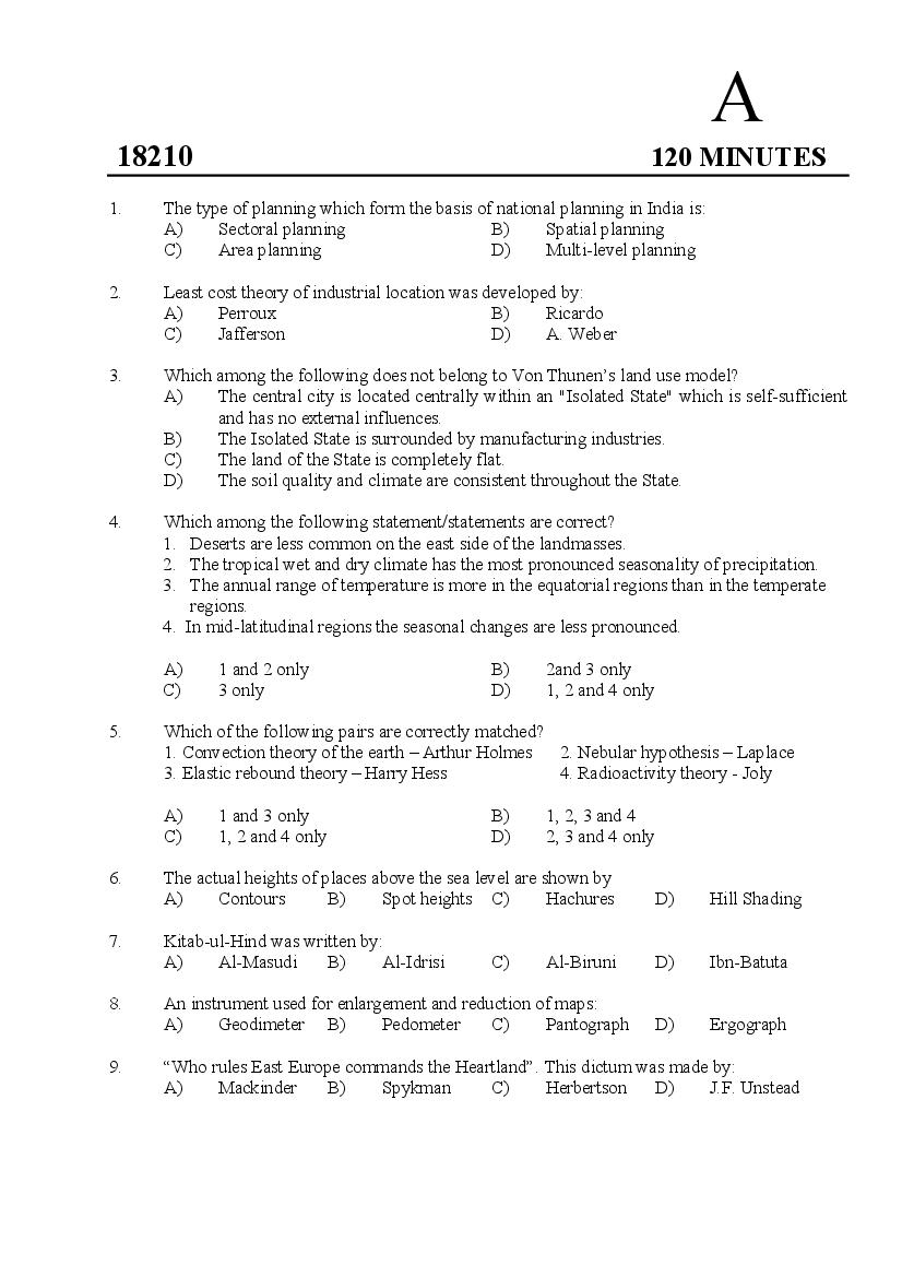
18210 120 MINUTES
1. The type of planning which form the basis of national planning in India is:
A) Sectoral planning B) Spatial planning
C) Area planning D) Multi-level planning
2. Least cost theory of industrial location was developed by:
A) Perroux B) Ricardo
C) Jafferson D) A. Weber
3. Which among the following does not belong to Von Thunen’s land use model?
A) The central city is located centrally within an "Isolated State" which is self-sufficient
and has no external influences.
B) The Isolated State is surrounded by manufacturing industries.
C) The land of the State is completely flat.
D) The soil quality and climate are consistent throughout the State.
4. Which among the following statement/statements are correct?
1. Deserts are less common on the east side of the landmasses.
2. The tropical wet and dry climate has the most pronounced seasonality of precipitation.
3. The annual range of temperature is more in the equatorial regions than in the temperate
regions.
4. In mid-latitudinal regions the seasonal changes are less pronounced.
A) 1 and 2 only B) 2and 3 only
C) 3 only D) 1, 2 and 4 only
5. Which of the following pairs are correctly matched?
1. Convection theory of the earth – Arthur Holmes 2. Nebular hypothesis – Laplace
3. Elastic rebound theory – Harry Hess 4. Radioactivity theory - Joly
A) 1 and 3 only B) 1, 2, 3 and 4
C) 1, 2 and 4 only D) 2, 3 and 4 only
6. The actual heights of places above the sea level are shown by
A) Contours B) Spot heights C) Hachures D) Hill Shading
7. Kitab-ul-Hind was written by:
A) Al-Masudi B) Al-Idrisi C) Al-Biruni D) Ibn-Batuta
8. An instrument used for enlargement and reduction of maps:
A) Geodimeter B) Pedometer C) Pantograph D) Ergograph
9. “Who rules East Europe commands the Heartland”. This dictum was made by:
A) Mackinder B) Spykman C) Herbertson D) J.F. Unstead
Page 2
a predicted value for an unmeasured location.
A) Kriging B) Regression
C) Co-variance analysis D) Spatial interpolation
11. In Christallers central place theory transport principle denoted by:
A) K2 B) K3 C) K4 D) K7
12. Choose the correct sequence of the tributaries of rivers from West to East:
A) Betwa, Chambal, Kosi, Gandak B) Chambal, Betwa, Gandak, Kosi
C) Kosi, Gandak, Chambal, Betwa D) Chambal, Kosi, Betwa, Gandak
13. The correct sequence of the given soil types in India in descending order of their areal
coverage is:
A) Alluvial soil, Laterite, Black soil, Red soil
B) Alluvial soil, Black soil, Red soil, Laterite
C) Alluvial soil, Red soil, Black soil, Laterite
D) Alluvial soil, Black soil, Laterite, Red soil
14. Who used the term ‘Necropolis’ for ghost towns?
A) Mumford B) S E Smailes C) Griffth Taylor D) Ullman
15. According to census 2011 the ascending sequence of the density of population in the
following states:
1. Uttar Pradesh 2. Bihar 3. Kerala 4. West Bengal
A) 1, 2, 3, 4 B) 1, 3, 4, 2 C) 2, 1, 3, 4 D) 2, 1, 4, 3
16. ‘Operational Geographer’ is the journal of:
A) Applied geography B) Welfare geography
C) Behavioural geography D) Economic geography
17. Which one among the following pairs of crops is the most leading in lower Gangetic Plain?
A) Wheat and Jute B) Paddy and Jute
C) Paddy and Cotton D) Wheat and Cotton
18. The scientist who clarified the ideas of uniformitarianism by Hutton:
A) J M Powell B) J Playfair C) Lyell D) Penck
19. The term used to denote a community of plants and animals that have common
characteristics for the environment they exist is:
A) Natural region B) Biome
C) Climatic region D) Ecosystem
20. Scattering occur to the electromagnetic radiation due to obscure made by oxygen and
nitrogen molecules:
A) Rayleigh scattering B) Mie scattering
C) Non selective scattering D) Selective scattering
2
Page 3
lack of distortion as a map is known as:
A) Composite image B) Ortho image
C) Enhanced image D) Panchromatic image
22. The headquarter of NRSC is in:
A) Hyderabad B) Dehradun C) Bengaluru D) New Delhi
23. Seiches are:
A) Storm waves
B) Periodic oscillation in an enclosed water body
C) Long shore currents
D) Waves during Tsunamis
Answer the questions 24 to 27 based on the direction given below:
The following four questions consist of two statements, one labeled as ‘Assertion’ (A) and
the other as ‘Reason’ (R). You have to examine these two statements carefully and select
answers to these questions using the codes given below.
Codes:
A) A and R are true and R is the correct explanation of A.
B) A and R are true but R is not the correct explanation of A.
C) A is true but R is false.
D) A is false but R is true.
24. Assertion (A): Cherrapunji receives both the southwest and northeast monsoons.
Reason (R): Cherrapunji lies on the windward side of the Khasi hills.
25. Assertion (A): Mediterranean regions receive winter rainfall.
Reason (R): During winter Mediterranean regions come under the influence of westerlies
26. Assertion (A): Graben is a narrow block dropped between two normal faults
Reason (R): Faulting is an expression of rock compression.
27. Assertion (A): Arid regions are characterized by severe moisture deficiency.
Reason (R) : Dry deciduous trees form the dominant vegetation in the arid regions.
28. Identify the odd one among the following:
A) Humboldt current B) Kuroshio current
C) Agulhas current D) Monsoon current
29. Which is a WRONG statement among the following?
A) Saline soils are light coloured and show poorly developed horizons.
B) Zonal soils are formed under conditions of good soil drainage.
C) Rendzina soils form an important soil group in Zonal soils
D) Hydromorphic soils belong to the soils of Intrazonal order.
3
Page 4
A) Complex thematic maps B) General Purpose maps
C) Special purpose maps D) Thematic maps
31. Identify the region consisting of a central place and the surrounding areas that are dependent
upon that place.
A) Cognitive region B) Functional region
C) Formal region D) Economic region
32. Among the following, which is not a characteristic of tropical desert?
A) Low relative humidity and cloud cover
B) Low frequency and amount of precipitation
C) Low wind velocities
D) High diurnal range of temperature
33. Which of the following is most likely to be found in the Central Business District of a city?
A) Shopping Mall B) A steel mill
C) Single family house D) A diary farm
34. Which of the following statements is/ are correct about the trade winds?
1. Trade winds are the prevailing winds between the equator and subtropical high
pressure belts to equator wards.
2. These prevailing winds blow from east to west.
3. The winds are predominantly from the south-west in the northern hemisphere and
from north-west in the southern hemisphere.
A) 1, 2 and 3 B) 1 and 2 only
C) 1 only D) 1 and 3 only
35. Which of the following statements are true?
1. Troposphere varies in its thickness between the equator and poles.
2. Ozone layer occurs in mesosphere.
3. Ionosphere is characterised by formation of thunderstorms.
4. Stratosphere does not experience normal lapse rate of temperature.
A) 1 & 3 only B) 1 & 4 only C) 3 & 4 only D) 2 & 4 only
36. The term ‘ecumene’ refers to:
A) Permanently inhabited lands B) Uninhabited lands
C) Sparsely inhabited lands D) Temporarily inhabited lands
37. The spatial resolution of World view-4 panchromatic image is :
A) 0.16 m B) 4m C) 1m D) 0.31 m
38. A GIS operation that superimposes multiple data sets together for the purpose of identifying
relationships between them is known as:
A) Proximity analysis B) Geo-referencing
C) Geo-coding D) Overlay analysis
4
Page 5
1. The concept of sequent occupance was forwarded by Whittlesey.
2. The ‘Principle of unity in diversity’ was developed by Fredrich Ratzel.
3. Yajur Veda describes the origin of the universe and the earth.
4. The French geographers, J. Brunhes and Emmanuel de Martonne did not bother the
dichotomy between physical geography and human geography.
Codes:
A) 1 and 2 only B) 1, 2 and 3 only
C) 2 and 3 only D) 1 and 4 only
40. A pioneer study on the level of regional development in India was made by:
A) Hanumantha Rao B) Dr. V. Nath
C) Hemalatha Rao D) Asok Mitra
41. A relict mountain in India among the following:
A) Satpura B) Vindhya C) Aravalli D) Maikala
42. Which is the country that has maximum biodiversity in the world?
A) Brail B) Madagascar C) Ecuador D) Columbia
43. Match list I (Climatic region) with list II (Urban centres)
List I (Climatic regions) List II (Urban centres)
a. Tropical savanna 1. Auckland
b. Mediterranean 2. Chicago
c. Temperate Grassland 3. Beirut
d. Cool temperate oceanic 4. Khartoum
A) a-4, b-3, c-2, d-1 B) a-2, b-4, c-3, d-1
C) a-1, b-2,c-4, d-3 D) a-2, b-1, c-4, d-3
44. The first paradigm to dominate human geography was:
A) Regional perspective B) Locational perspective
C) Environmental determinism D) Earth science tradition
45. Drainage density refers to :
A) Number of streams per unit area
B) Number of first order streams per unit area
C) Ratio of stream length to number
D) Length of streams per unit area
46. The colour in which living vegetation appears on false-color IR images is:
A) White B) Black C) Blue D) Red
5
Page 6
A) Csa - Hot summer Mediterranean type climate
B) Bwh - Hot desert
C) Aw - Tropical Savannah
D) As - Monsoon type with short dry season
48. Rio Grande rise is found in:
A) Pacific ocean B) Atlantic ocean
C) Indian ocean D) Arctic ocean
49. Identify the philosophy to which the ‘Locational Analysis Model’ is based :
A) Positivism B) Existentialism
C) Idealism D) Determinism
50. Who first made the point that the trickling forces are favourable forces for the development
of growth points?
A) A.O Hirschman B) Gunnar Myrdal
C) Harrold Damor D) Boudeville
51. The rural literacy rate in India as per census 2011 is:
A) 68.90% B) 79.2% C) 84.9% D) 72.3%
52. Consider the following urban agglomerations of Kerala.
1. Thiruvananthapuram 2. Kochi 3. Malappuram 4. Kozhikode
The correct sequence in the decreasing order of their population is:
A) 1, 3, 4 and 2 B) 2, 4, 1 and 3
C) 3, 2, 4 and 1 D) 2, 3, 4 and 1
53. The philosophical approach which emphasizes the autonomy of the social sciences, the
importance of understanding human activity in terms of thought and the central role of
uniqueness in human geography is :
A) Idealism B) Realism C) Functionalism D) Humanism
54. The proposed Sagar port project will be located in :
A) Gujarat B) Maharashtra C) Odisha D) West Bengal
55. The concept of Spread and backwash effect was developed by:
A) G. Myrdal B) Perroux C) Laissez Faire D) Hirchman
56. Which is the type of landform where sink holes are numerous and it is a characteristic of that
landform?
A) Karst topography B) Fluvial landscape
C) Glaciated landscape D) Aeolian landscape
57. Contour interval in the Survey of India topographic map with the number 58/P/16 SE is:
A) 20 metres B) 10 metres C) 50 metres D) 100 metres
6
Page 7
A) Selection B) Compilation
C) Toponomy D) Simplification
59. The form of agriculture which is best developed in the monsoon lands of Asia is :
A) Simple subsistence farming B) Sedentary subsistence farming
C) Intensive subsistence agriculture D) Extensive, mechanized grain cultivation
60. The concept of Urban field was introduced by :
A) A. E Smailes B) H. L Green
C) Andre Allix D) Harold Carter
61. In which of the following cities will the diurnal range of temperature be the lowest:
A) Jaipur B) Kuala Lumpur
C) New York D) London
62. Match List I with List II and select the correct answer using the codes given below the lists.
List I List II
a. Functional classification of 1. C.C. Colby
cities
b. Concentric zone theory 2. Homer Hoyt
c. Basic and non basic concept 3. C D Harris
in urban geography
d Centrifugal and centripetal 4. Ernest W Burgess
forces in urban geography
Codes
a b c d
A) 3 4 2 1
B) 4 3 2 1
C) 3 4 1 2
D) 2 4 3 1
63. An example for Target group programmes is :
A) Command Area Development Programme
B) Integrated Watershed Development Programme
C) Small Farmers Development Agency
D) Jawaharlal Nehru National Urban Renewal Mission
64. The largest natural rubber producing country in the world:
A) Malysia B) India C) Brazil D) Thailand
65. Among the following which one is used for crop combination analysis?
A) Location quotient method B) Bhatia’s technique
C) Gibbs and Martin technique D) Rafaullah’s technique
7
Page 8
A) An incised meander
B) An offshoot of a braided channel
C) A Flow of melt water along a glaciated valley
D) A Flow of water parallel to the main stream due to the presence of natural levee in
between.
67. An advocate of Exceptionalism in Geography:
A) N. M Fenneman B) Johnston R. J
C) T.H. Elkins D) Fred.K.Schaefer
68. Match List I with List II and select the correct answer from the codes given below.
List I List II
a. Quantitative revolution 1. W.S. Reilley
b. Areal differentiation 2. Spykman
c. Rimland theory 3. I. Burton
d. Gravity Model 4. Richard Hartshrone
A) a-2, b-4, c-3, d-1 B) a-3, b-2, c-4, d-1
C) a-2, b-1, c-4, d-3 D) a-3, b-4, c-2, d-1
69. The map projection in which loxodromes are shown as straight lines is:
A) Bonne’s projection B) Mercator projection
C) Cylindrical equidistant projection D) Cylindrical equal area projection
70. Which of the following statements are correct?
1. NH 49 Connects Kundannoor and Bodimettu.
2. Malayalam language belong to the Austric linguistic family.
3. The Kalakad Mundanthurai Tiger Reserve is in Agasthyamalai Biosphere Reserve.
4. The largest bauxite reserves in Kerala are at Sasthavattom and Attipra areas of
Thiruvananthapuram.
A) 1, 2 and 4 only are correct B) 1 and 3 only are correct
C) 2, 3 and 4 only are correct D) 1, 2, 3 and 4 are correct
71. A line drawn about a sources of raw materials or markets where transport costs are equal to
explore is known as:
A) Isodapane B) Isochrone
C) Isotim D) Isoline
72. The book ‘Geography of Puranas’ is authored by:
A) Prof. S.S.Sarma B) Prof. S.M.Ali
C) Prof. R.P.Misra D) Prof. K.R. Dikshit
8
Page 9
Rivers Tributaries
a. Godavari 1. Tawa river
b. Tapi 2. Koyna river
c. Krishna 3. Girna river
d. Narmada 4. Pranhita river
Codes:
A) a-4, b-1, c-2, d- 3 B) a-3, b-2, c-4, d-1
C) a-4, b-3, c-2, d-1 D) a-2, b-1, c-4, d-3
74. Consider the following statements with regard to the jet streams
1. The genesis of jet streams related to temperature gradient from equator to poles
2. The wavy jet streams are called Ross by waves
3. The period of transformation of straight path of jet streams to wavy path is called
index cycle.
4. Circulation of jet streams are observed between equator and 300 latitudes in both the
hemispheres.
Which of the above statements are correct?
A) 1 only B) 2 and 3 only
C) 1, 2 and 3 only D) 1, 2, 3 and 4
75. Largest coal reserves of the world are found in:
A) Irkutsk region B) Omsk – Tornsk region
C) Kuznetsk Basin D) Tashkent Basin
76. Given below are the climatic data of a particular station. In which of the climatic region is the
place located.
Months Jan Feb Mar Apr May Jun July Aug Sep Oct Nov Dec
Temperature
25.0 25.8 27.9 29.9 29.0 27.6 26.1 26.2 27.0 28.4 27.7 25.9
(0C)
Rainfall
0.8 0.4 0.9 3.7 28.0 47.1 54.5 51.1 39.7 18.8 7.2 0.7
(mm)
A) Mediterranean climatic region B) China type climatic region
C) Tropical monsoon climatic region D) Rainy tropical region
9
Page 10
List I (books List II (Author)
a. Morphology of the landscape 1. R. Peet
b. Third space 2. Wilbur Zelinsky
c. Women in Geography 3. Carl. O. Sauer
d. Geography of power 4. E. Soja
A) a-1, b-3, c-2, d-4 B) a-4 ,b-3, c-1,d-2
C) a-2, b-3, c-1, d-4 D) a-3, b-4, c-2, d-1
78. In the world copper production, top rank is occupied by:
A) India B) USA C) Canada D) Chile
79. Which one of the following pairs is correctly matched?
A) Cayman trough - Mediterranean sea
B) Carlsberg Ridge - Arabian sea
C) Seychelles Island - Atlantic Ocean
D) Funafuti Atoll - West Indies
80. Consider the following statements and select the correct answer using the codes given below:
1. The ‘boundary model’ is also called as ‘topological data model’
2. Spatial data lacks in positional values.
Codes:
A) Only 1 is correct B) 1 and 2 are correct
C) Only 2 is correct D) Neither 1 nor 2 is correct
81. The headquarters of Survey of India is in:
A) Kolkata B) New Delhi
C) Dehradun D) Pune
82. Who is regarded as the father of humanistic approach in geography?
A) Yi-Fu Tuan B) William Bunge
C) Auguste Comte D) Brian J L Berry
83. The largest delta in the world is formed by :
A) Amazon River B) Mississippi River
C) Ganga- Brahmaputra Rivers D) Nile River
84. Which among the following is a reason for the decline of groundwater?
A) Pollution of groundwater B) Excessive evaporation
C) Overuse of groundwater D) Soil erosion
10
Page 11
A) Gujarat B) Maharashtra
C) Uttar Pradesh D) West Bengal
86. Identify the westernmost metropolitan city in India.
A) Mumbai B) Ahmedabad C) Bengaluru D) Surat
87. Arrange the following periods in chronological order and select the correct answer using the
code given below:
1. Carboniferous 2. Devonian 3. Permian 4. Silurian
Codes:
A) 4, 2, 3, 1 B) 4, 2, 1,3 C) 2, 4, 1, 3 D) 2, 4, 3, 1
88. The type of vegetable farming in which vegetable farms are located at an overnight distance
from the market is:
A) Truck farming B) Market gardening
C) Orchard farming D) Mixed farming
89. The largest landlocked country of the world is:
A) Kazakhstan B) Paraguay
C) Niger D) Afghanistan
90. Collission-coalescense theory explains:
A) Formation of Tornadoes B) Formation of precipitation
C) Formation of cyclones D) Formation of clouds
91. Arrange the following mangrove eco systems on Indian coastlines in increasing size:
1. Gulf of Kutchh 2. Andaman and Nicobar Islands 3. Sunderbans
A) 1, 2, 3 B) 3, 2, 1 C) 2, 1, 3 D) 2, 3, 1
92. Gaddis and Bhotiyas are:
A) Gatherers in Amazon basin B) Shifting cultivators in central America
C) Hunters in Arctic region D) Transhumances in Himalayas
93. In which of the following climate will chemical weathering be most rapid?
A) Hot and dry B) Hot and humid
C) Cold and dry D) Cold and humid
94. Which among the following is a push factor for migration?
A) Non polluted environment B) Employment opportunities
C) High salary D) Political turmoil
95. What is the correct sequence in the erosion of a headland?
A) Headland, arch, cave, stack B) Headland, stump, stack, cave
C) Headland, cave, arch, stack D) Headland, stack, bay, arch, stump
11
Page 12
A) 10000 to 29999 B) 20000 to 39999
C) 10000 to 19999 D) 20000 to 49999
97. Among the following map projections, which is more suitable for the representation of India?
A) Zenithal equatorial projection
B) Sanson - Flamsteed’s projection
C) Mollweide’s projection
D) Conical projection with two standard parallels
98. The Concept of ‘Grand Base Level’ was formulated by:
A) G.K. Gilbert B) W.M. Davis C) J.W. Powell D) L.C. King
99. Which is the largest coal field in India?
A) Jharia B) Korba C) Singaneri D) Raniganj
100. Among the following statements which is/ are true to squatter settlements?
1. There is no legal title to the land occupied
2. These are located in the city centre
3. They invariably grow up just on the edge of the business area of great cities
4. Squatter settlements develop only in industrialized urban centres.
A) 1 only B) 1 and 2 only C) 2 and 4 only D) 3 and 4 only
101. Which is the longest stretch of Himalaya?
A) Nepal Himalayas between Kali and Teesta
B) Punjab Himalayas between Indus and Satluj
C) Kumaon Himalayas between Satluj and Kali
D) Assam Himalayas between Teesta and Brahmaputra
102. Albedo of the earth means:
A) Amount of radiation absorbed by the atmosphere
B) The reflected amount of radiation from the surface of the earth
C) Long wave radiation from the surface of the earth
D) The amount of radiation absorbed by the earth
103. The United Nations Climatic Change Conference 2017 was held in :
A) Cancun, Mexico B) Bonn, Germany
C) Lima, Peru D) Durban, South Africa
104. The water channel separating Amini and Cannanore group of islands in Lakshadweep:
A) 11 degree channel B) 10 degree channel
C) 9 degree channel D) 12 degree channel
105. A ring-like reef, which partly or completely encloses a lagoon:
A) Barrier island B) Barrier reef
C) Atoll D) Fringing reef
12
Page 13
A) The North-West Atlantic region B) The North-West Pacific region
C) The North-East Atlantic region D) The North-East Pacific region
107. The phenomenon characterized by unusually warm ocean temperatures in the equatorial
Pacific is known as:
A) El Nino B) La Nina
C) ENSO D) Southern Oscillation
108. The major river flowing through the desert region in India:
A) Ganga B) Luni C) Chambal D) Indus
109. ‘Pays concept’ is associated with:
A) German school B) French school
C) Russian school D) American school
110. The distribution of population in a place is best shown in:
A) Political maps B) Choroplethmaps
C) Dot maps D) Cadastral maps
111. The lake which is not tectonic in origin:
A) Lake superior B) Caspian sea
C) Lake Titicaca D) Dead sea
112. What is the scale of the map baring the number 58 H/2 NW?
A) 1: 250,000 B) 1: 50,000 C) 1: 25,000 D) 1: 63,360
113. Shimsa is a tributary of:
A) Mahanadi B) Kaveri C) Godavari D) Krishna
114. The area common to two successive aerial photographs along the same flight strip:
A) Mosaic B) Sidelap C) Overlap D) Aspect
115. The term used to describe the process of associating a physical map or raster image with
spatial locations.
A) Edge matching B) Georeferencing
C) Geocoding D) Digitizing
116. Who first divided the whole world in to different agricultural regions?
A) Von Thunen B) Richtofen
C) Ratel D) Whittlesey
117. The most common weather phenomenon in the troposphere during winter nights with clear
sky and feeble winds is:
A) Frontogenesis B) Jet streams
C) Inversion of temperature D) Snowfall
13
Page 14
are:
A) Insequent streams B) Consequent streams
C) Resequent streams D) Obsequent streams
119. Which of the following statements are true?
1. Pittsburgh, known as the iron and steel capital of the world, owes its growth to the
coal fields in Central Appalachian field
2. Lanarkshire, Fifeshire, Ayrshire and Midlothian are the major coal fields in the
Pennine coalfields
3. Singapore possess no oil itself but several refineries have been set up in Singapore.
4. The Ukraine industrial region is developed because of the advantages of the Donetz
coal field and Krivoi Rog- Kerch iron – field.
A) 1 and 2 only B) 1, 2 and 3 only
C) 2 and 4 only D) 3 and 4 only
120. In Sahara, Gour is the local name of:
A) Barchans B) Pediments
C) Mushroom Rock D) Inselbergs
****************
14
Document Details
| Board / Org | Kerala Exams |
| Exam | Kerala SET |
| Type | Question Paper |
| Pages | 14 |
| Updated | 23 Oct 2026 |