CBSE Class 12 Marking Scheme 2022 for Geography
Finished viewing? Save it for later —
Download CBSE Class 12 Marking Scheme 2022 for Geography (PDF · 9 pages)About CBSE Class 12 Marking Scheme 2022 for Geography
CBSE Class 12 Marking Scheme 2022 for Geography is available here for free download. Published by CBSE for Class 12, this marking scheme can be viewed online or downloaded as a PDF (9 pages). Candidates preparing for Class 12 can use CBSE Class 12 Marking Scheme 2022 for Geography to understand the exam pattern, the type of questions asked, and the overall difficulty level.
Frequently Asked Questions
How can I download CBSE Class 12 Marking Scheme 2022 for Geography?
Open this page and click the Download button to save CBSE Class 12 Marking Scheme 2022 for Geography as a PDF. It is completely free on AglaSem Docs.
Is CBSE Class 12 Marking Scheme 2022 for Geography free to download?
Yes. CBSE Class 12 Marking Scheme 2022 for Geography can be viewed online and downloaded as a PDF free of cost on AglaSem Docs.
How many pages does CBSE Class 12 Marking Scheme 2022 for Geography have?
CBSE Class 12 Marking Scheme 2022 for Geography contains 9 pages, which you can read online or download together as a single PDF.
Where can I find more Class 12 study material?
You can find more Class 12 question papers, sample papers, syllabus, and answer keys on AglaSem Docs.
CBSE Class 12 Marking Scheme 2022 for Geography – Text
Read the full text of this marking scheme below — useful to quickly search, copy and reference the content online without downloading the PDF.
📄 View text version (9 pages)
Page 1
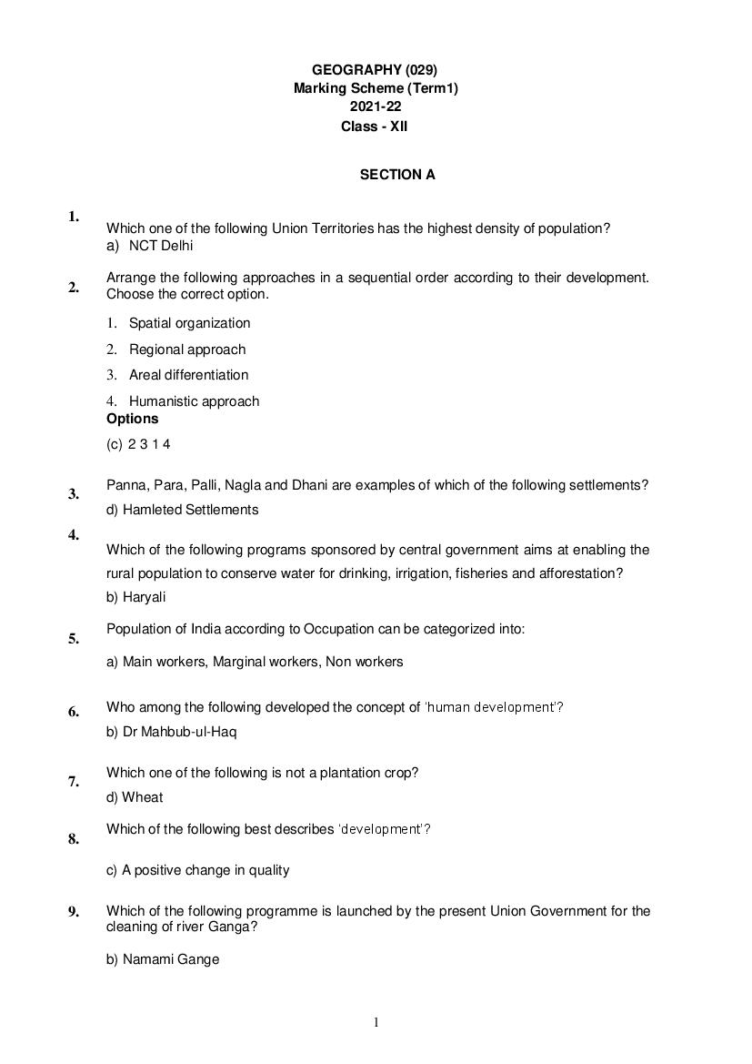
Marking Scheme (Term1)
2021-22
Class - XII
SECTION A
1.
Which one of the following Union Territories has the highest density of population?
a) NCT Delhi
Arrange the following approaches in a sequential order according to their development.
2. Choose the correct option.
1. Spatial organization
2. Regional approach
3. Areal differentiation
4. Humanistic approach
Options
(c) 2 3 1 4
Panna, Para, Palli, Nagla and Dhani are examples of which of the following settlements?
3.
d) Hamleted Settlements
4.
Which of the following programs sponsored by central government aims at enabling the
rural population to conserve water for drinking, irrigation, fisheries and afforestation?
b) Haryali
Population of India according to Occupation can be categorized into:
5.
a) Main workers, Marginal workers, Non workers
6. Who among the following developed the concept of ‘human development’?
b) Dr Mahbub-ul-Haq
Which one of the following is not a plantation crop?
7.
d) Wheat
Which of the following best describes ‘development’?
8.
c) A positive change in quality
9. Which of the following programme is launched by the present Union Government for the
cleaning of river Ganga?
b) Namami Gange
1
Page 2
10.
c. Chandigarh
11. Which one of the following is not a method of mining?
d) Refining
According to census 2011, which of the following depicts the percentage of
12.
the level of urbanization in India?
a) 31.16 %
13. According to Census of India, migration is enumerated on which of the following basis?
c) Place of Origin as well as Place of Residence
14. Clustered settlements are not found in which of the following regions of India?
b) Water scarce areas of Rajasthan
15. Coffee Plantations in Brazil are known as:
c) Fazendas
Who among the following is related to ‘capability approach’?
16.
b) Prof Amartya Sen
Which of the following areas of our country are deficient in rainfall and are drought
17.
prone?
b) Deccan Plateau
18. Which of the following colonial super power had monopoly over sugarcane plantation in
Indonesia?
c) Dutch
Which of the following is a good example of Fort town?
19.
a) Jaipur
20.
Which one of the following concepts is related to Naturalization of Humans?
a) Environmental Determinism
2
Page 3
21.
a) Derive economic needs from primary activities
Which of the following sectors has used the highest percentage of total water in India?
22.
c) Agriculture
Who among the following has introduced the concept of Neo-determinism?
23.
b) Griffith Taylor
Which of the following attributes has not been adversely affected by Age and Skill
24.
selective migration?
a) Downfall in working population in rural areas
SECTION B
Question no. 25-29 are based on map and are mandatory to attempt.( Visually
Impaired students will also attempt MCQs)
25. Choose the country with largest Geographical area in the African Continent.
a). Algeria
26. Which one of the followings is a region of commercial grain farming practiced in Europe?
b) Steppes
Which of the following is a region of North America practicing subsistence gathering?
27.
c) North Canada
Which of the following terminal stations connect Trans-Canadian Railway?
28.
a) Halifax and Vancouver
3
Page 4
c) Rhine Waterway
Question no. 30-48
Consider the following statements and choose the correct option from the given options-
30.
1. Population grown rapidly during the sixteenth and seventeenth century.
2. Expansion of world trade during sixteenth and seventeenth century is an important
cause of it.
d) Both statements are correct and statement 2 correctly explains the statement 1.
Which of the following pair is not correctly matched
31.
PILLARS OF HUMAN DEVELOPENT INDICATORS
c. Productivity - Resources must be used keeping in mind the future
”Each community occupies a well-identified territory as a matter of tradition”.
32.
Above mentioned line is an important characteristic of which of the following activity?
b) Nomadic herding
33. Which of the following statement is not true regarding the ‘Smart City Mission’?
d) Increase in unemployment
34.
Which of the following is NOT an environmental consequence of migration?
b) Mixing of diverse culture
In Himalayan regions which of the following tribes are linked with the activity of
35.
Transhumance?
c. Bakarwals
Match the column I with Column II and choose the correct options with the help of given
36. Codes.
COLUMN I COLUMN II
(CITIES) (FUNCTIONAL SPECIFICATION)
I. Ambala 1. Mining town
II. Mughal Sarai 2. Transport town
III. Ankaleshwar 3. Educational town
IV. Aligarh 4.Garrison town
V. Shimla 5. Commercial town
VI .Saharanpur 6. Tourist town
4
Page 5
I II III IV V VI
b. 4 2 1 3 6 5
37. This age was marked by use of computers and sophisticated statistical tools. Laws of
physics were often applied to map and analyze. Select the option.
d) Spatial organization
In which of the following streams of migration, females pre-dominate in both intra-state
38. and inter-state migration?
c) Rural to rural
39. Which of the following column is not matched correctly?
ACTIVITY CHARACTERISTICS
d. Viticulture Rearing of fish
Consider the following features and choose the correct title after associating them.
40.
I.
More often such a pattern may also result from segregation or fragmentation
of large compact village.
II. The land- owning and dominant community occupies the central part of the main
village whereas people of lower strata of society and menial workers settle on
the outer flanks of the village.
III. They are found in Gujarat plains and some parts of Rajasthan.
OPTIONS-
b. Semi-clustered or fragmented
Consider the following and choose the correct answer from the given options-
41.
I. Work participation rate tend to be higher in the areas of lower levels of
economic development.
II. Number of manual workers are needed to perform the subsistence or near
subsistence economic activities
Options-
b) Both statements are correct and statement II correctly explains statement I
Consider the following statements and choose the correct option for the same:
42.
1. Grape cultivation is the specialty of the Mediterranean agriculture.
2. Wines are produced from high quality grapes and the inferior grapes are dried into
raisins and Currants.
Options;
b. Both 1 and 2 are correct
5
Page 6
43.
Codes.
COLUMN I (RIVERS) COLUMN II (POLLUTED PLACE)
I Yamuna 1. Hyderabad
II Kali 2. Kanpur and Varanasi
III Gomati 3. Ahmedabad
IV Sabarmati 4. Lucknow
V Ganga 5. Muzaffar Nagar
VI Musi 6. Delhi and Etawah
Codes-
I II III IV V VI
a. 6 5 4 3 2 1
44. In the year 2015, a policy was formulated for the adolescents to give them
proper guidance and the better development of their talent. Select the correct
answer.
a) Skill development and entrepreneurship
Which of the following pairs is not matched correctly?
45.
CITIES BASIS OF DEVELOPMENT
c) Kolkata -On cultural basis
Match the column I with column II and choose the correct answer with the help of given
46. Codes-
COLUMN I (CITIES) COLUMN II (TYPES OF CITIES)
I Jamshedpur 1.Summer resort
II. Bhuvaneshwar 2. Satellite town
III. Ghaziabad 3. Industrial town
IV Mussoorie 4. Commercial port
V Goa 5. Administrative town
CODES-
I II III IV V
b. 3 5 2 1 4
Consider and evaluate the following statements than choose correct options for
47.
them from the given options.
1. Many species now have become extinct or endangered due to illegal hunting.
6
Page 7
number of animals killed were limited.
Options;
c) Both statements 1 and 2 are correct
Make correct pairs of the following two columns and select the correct
48. option.
Period
Approach
1. Early colonial period (a) Exploration & Description
2. Late 1950’s to the late 1960’s (b) Regional Analysis
3. Later colonial period (c) Aerial Differentiation
4. 1930’s through the inter-war period (d) Spatial Organization
(A) 1. (a) 2. (d) 3. (b) 4. (c)
SECTION C
SOURCE BASED QUESTIONS
Question number 49 to 52 are compulsory to attempt
Jal Kranti Abhiyan (2015-16)
Water is a recyclable resource but its availability is limited and the gap between supply
and demand will be widening over time. Climate change at the global scale will be
creating water stress conditions in many regions of the world. India has a unique situation
of high population growth and rapid economic development with high water demand. The
Jal Kranti Abhiyan launched by the Government of India in 2015–16 with an aim to
ensure water security through per capita availability of water in the country. People in
different regions of India had practised the traditional knowledge of water conservation
and management to ensure water availability. The Jal Kranti Abhiyan aims at involving
local bodies, NGOs and cititzens, at large, in creating awareness regarding its objectives.
The following activities have been proposed under the Jal Kranti Abhiyan: 1. Selection of
one water stressed village in each 672 districts of the country to create a ‘Jal Gram’. 2.
Ídentification of model command area of about 1000 hectares in different parts of the
country, for example, UP, Haryana (North), Karnataka, Telangana, Tamil Nadu (South),
Rajasthan, Gujarat (West), Odisha (East), Meghalaya (North-East). 3. Abatement of
pollution: • Water conservation and artificial recharge. • Reducing groundwater pollution. •
Construction of Arsenic-free wells in selected areas of the country. 4. Creating mass
awareness through social media, radio, TV, print media, poster and essay writing
competitions in schools. Jal Kranti Abhiyan is designed to provide livelihood and food
security through water security.
Present day world is experiencing acute water paucity due to:
49.
a). Climate Change
Which of the following is not a characteristic feature of Model Command Area in India?
50.
d). Not concerned with food security and livelihood of the people
The Objective of the Jal Kranti Abhiyan is achieved through:
51.
7
Page 8
The main aim of The Jal Kranti Abhiyan is to ensure water security through-----.
52.
c). Per capita availability of water
GRAPH BASED QUESTION
Study the given graph carefully and answer the following questions:
How does the natural increase in population occur, as per the graph?
53.
a) Birth Rate – Death Rate
54. What does the transition from high fluctuating stage to low fluctuating stage indicate?
b) Shift from Rural Agrarian economy to Urban Industrial economy
55.
From the given graph, what condition can you infer about the developing countries?
c) High Birth Rate and Low Death Rate
In which stage of Demographic Transition, population explosion took place-
56.
b) Stage II
For Visually Impaired Candidates in lieu of Q No. 53-56 (Graph Based Question)
Q.53. Why are Fertility and Mortality rates high in the first stage of Demographic Transition
Theory?
b) People reproduce more to compensate for the deaths due to epidemics.
Q.54. What led to decline in Mortality rate in the Second stage of Demographic Transition
Theory
a) Due to improvement in Sanitation and Health conditions.
8
Page 9
Transition Theory?
c) The population becomes urbanized and has high technical knowhow.
a) There is acute food shortage in countries with a high Human Development Index.
Q.56. In which stage of Demographic Transition, population explosion took place
b) Stage II
DATA BASED QUESTIONS
Which year has seen a negative population growth rate in India?
57.
b. 1921
What was the highest recorded growth rate of population in India?
58.
b. 24.80
Which year has recorded the highest growth of population in India in terms of absolute
59. numbers?
a. 2001
How much population increase has been registered between the census years 1911 to
60. census year 2011?
d) 971797095
9
Document Details
| Board / Org | CBSE |
| Exam | Class 12 |
| Type | Solution |
| Pages | 9 |
| Updated | 30 Apr 2026 |