HBSE Class 11 Sample Paper 2026 Answers Geography
Finished viewing? Save it for later —
Download HBSE Class 11 Sample Paper 2026 Answers Geography (PDF · 5 pages)About HBSE Class 11 Sample Paper 2026 Answers Geography
HBSE Class 11 Sample Paper 2026 Answers Geography is available here for free download. Published by Haryana Board for Class 11, this answer key can be viewed online or downloaded as a PDF (5 pages). Candidates preparing for Class 11 can use HBSE Class 11 Sample Paper 2026 Answers Geography to understand the exam pattern, the type of questions asked, and the overall difficulty level.
Frequently Asked Questions
How can I download HBSE Class 11 Sample Paper 2026 Answers Geography?
Open this page and click the Download button to save HBSE Class 11 Sample Paper 2026 Answers Geography as a PDF. It is completely free on AglaSem Docs.
Is HBSE Class 11 Sample Paper 2026 Answers Geography free to download?
Yes. HBSE Class 11 Sample Paper 2026 Answers Geography can be viewed online and downloaded as a PDF free of cost on AglaSem Docs.
How many pages does HBSE Class 11 Sample Paper 2026 Answers Geography have?
HBSE Class 11 Sample Paper 2026 Answers Geography contains 5 pages, which you can read online or download together as a single PDF.
Where can I find more Class 11 study material?
You can find more Class 11 question papers, sample papers, syllabus, and answer keys on AglaSem Docs.
HBSE Class 11 Sample Paper 2026 Answers Geography – Text
Read the full text of this answer key below — useful to quickly search, copy and reference the content online without downloading the PDF.
📄 View text version (5 pages)
Page 1
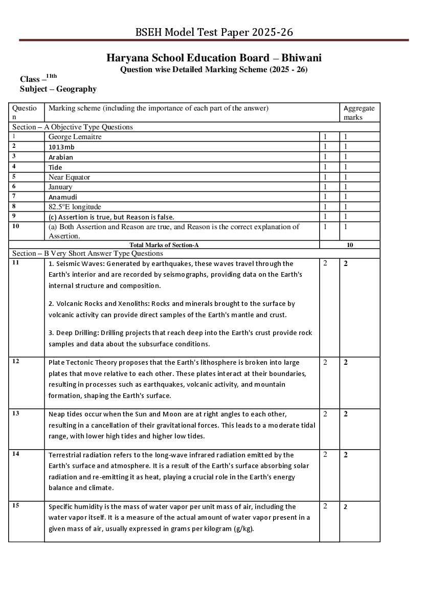
Question wise Detailed Marking Scheme (2025 - 26)
Class –11th
Subject – Geography
Questio Marking scheme (including the importance of each part of the answer) Aggregate
n marks
Section – A Objective Type Questions
1 George Lemaitre 1 1
2 1013mb 1 1
3 Arabian 1 1
4 Tide 1 1
5 Near Equator 1 1
6 January 1 1
7 Anamudi 1 1
8 82.5°E longitude 1 1
9 (c) Assertion is true, but Reason is false. 1 1
10 (a) Both Assertion and Reason are true, and Reason is the correct explanation of 1 1
Assertion.
Total Marks of Section-A 10
Section – B Very Short Answer Type Questions
11 1. Seismic Waves: Generated by earthquakes, these waves travel through the 2 2
Earth's interior and are recorded by seismographs, providing data on the Earth's
internal structure and composition.
2. Volcanic Rocks and Xenoliths: Rocks and minerals brought to the surface by
volcanic activity can provide direct samples of the Earth's mantle and crust.
3. Deep Drilling: Drilling projects that reach deep into the Earth's crust provide rock
samples and data about the subsurface conditions.
12 Plate Tectonic Theory proposes that the Earth's lithosphere is broken into large 2 2
plates that move relative to each other. These plates interact at their boundaries,
resulting in processes such as earthquakes, volcanic activity, and mountain
formation, shaping the Earth's surface.
13 Neap tides occur when the Sun and Moon are at right angles to each other, 2 2
resulting in a cancellation of their gravitational forces. This leads to a moderate tidal
range, with lower high tides and higher low tides.
14 Terrestrial radiation refers to the long-wave infrared radiation emitted by the 2 2
Earth's surface and atmosphere. It is a result of the Earth's surface absorbing solar
radiation and re-emitting it as heat, playing a crucial role in the Earth's energy
balance and climate.
15 Specific humidity is the mass of water vapor per unit mass of air, including the 2 2
water vapor itself. It is a measure of the actual amount of water vapor present in a
given mass of air, usually expressed in grams per kilogram (g/kg).
Page 2
Temperature inversion occurs when the temperature increases with altitude, 2
contrary to the normal decrease. This phenomenon is often observed in valleys or
near the surface, especially during winter nights or in areas with high atmospheric
stability, leading to unique weather patterns.
16 Social forestry refers to the management and protection of forests, as well as 2 2
afforestation efforts, involving local communities. It aims to meet the needs of rural
people for fuelwood, fodder, and timber while promoting sustainable forest
management and conservation.
or
Ferrel's Law states that winds in the mid-latitudes are deflected to the right in the 2
Northern Hemisphere and to the left in the Southern Hemisphere due to the
Coriolis effect. This law helps explain the direction of winds and storm systems in
these regions.
Total Marks of Section-B 12
Section – C Short Answer Type Questions
17 1. Systematic Geography: Studies geographic phenomena (e.g., climate, landforms, 3 3
population) globally, focusing on patterns, processes, and principles.
2. Regional Geography: Examines specific regions, analyzing the unique
combination of geographic features, relationships, and characteristics within those
areas.
18 1. Weathering: Breakdown of rocks into smaller fragments or minerals without 3 3
removing them from their original location.
2. Erosion: Removal and transportation of weathered rock materials (sediments) by
natural forces like wind, water, or ice.
19 Monsoon Burst: 3 3
A monsoon burst refers to the sudden and significant increase in rainfall that marks
the arrival of the monsoon season. This phenomenon occurs when the normal
rainfall increases suddenly and lasts for several days, bringing much-needed relief
from the scorching summer heat.
Place with Maximum Annual Rainfall:
The place that receives the maximum annual rainfall in India is Mawsynram, located
in the East Khasi Hills district of Meghalaya. It receives an average annual rainfall of
over 11,777 mm, making it one of the wettest places on Earth.
20 The hydrological cycle, also known as the water cycle, is the continuous process by 3 3
which water is circulated between the Earth's oceans, atmosphere, and land. It
involves the movement of water in three phases: evaporation, condensation, and
precipitation, ensuring the distribution of water throughout the planet.
21 Global warming refers to the long-term rise in the average surface temperature of 3 3
the Earth due to the increasing levels of greenhouse gases in the atmosphere.
1. 1.Greenhouse gases: Burning fossil fuels (coal, oil, gas) releases CO2,
methane, and other gases that trap heat.
2. 2.Deforestation: Cutting down forests reduces carbon absorption,
increasing atmospheric CO2.
Page 3
Composition of Atmosphere: 3
The Earth's atmosphere is composed of several gases, including:
1. Nitrogen (N2): About 78%
2. Oxygen (O2): About 21%
3. Argon (Ar): About 0.93%
4. Carbon dioxide (CO2): About 0.04%
5. Other gases: Trace amounts of neon, helium, methane, and others.
These gases play vital roles in supporting life and regulating the planet's climate.
22 Earthquakes in the Himalayas and North Eastern India: 1 3
The Himalayas and North Eastern India are prone to earthquakes due to:
1.Tectonic plate movement: The Indian plate is moving northwards towards the 1
Eurasian plate, causing stress and resulting in earthquakes.
2.Active mountain-building process: The Himalayas are a young and fragile 1
mountain range, still forming due to plate movement, making it seismically active.
These factors make the Himalayas and North Eastern India highly susceptible to
earthquakes.
Or
Convectional Rainfall: 3
Convectional rainfall occurs when the sun heats the ground, warming the air above
it. As the warm air rises, it cools, condenses, and forms clouds, resulting in
precipitation.
Process:
1. Ground heating → Air rises → Cooling and condensation → Cloud formation →
Rainfall
This type of rainfall is common in tropical regions and often leads to thunderstorms
and heavy downpours.
Total Marks of Section-C 18
Section – D Long Answer Type Questions
23 Depositional Features Formed by Rivers: 5
Rivers create various depositional features as they carry and deposit sediments
along their course. Some features include:
1. Floodplains: Flat areas adjacent to rivers that are periodically flooded and 1
covered with sediment.
2. Deltas: Triangular landforms at the river's mouth, formed by the accumulation of 1
sediments as the river meets a sea or lake.
3. Alluvial Fans: Fan-shaped deposits of sediment that form when a river flows 1
down a steep slope and spreads out onto a flatter area.
4. Levees: Raised banks of sediment along the river's course, formed by repeated 1
flooding and deposition.
5. Point Bars: Crescent-shaped deposits of sediment that form on the inner bends 1
of meandering rivers.
Or
The Continental Drift Theory, proposed by Alfred Wegener, suggests that the 5
continents were once joined together in a single supercontinent called Pangaea and
have since drifted apart.
Evidence:
Page 4
2. Similar rock formations: Similar rock formations and fossil evidence are found on
different continents.
3. Fossil evidence: Fossils of the same species are found on different continents,
indicating a common ancestry.
4. Paleoclimatic evidence: Similar climatic features, such as coal deposits, are found
in regions with different current climates.
5. Mid-ocean ridges: The discovery of mid-ocean ridges and magnetic striping
supports seafloor spreading, which is linked to continental drift.
This theory laid the foundation for modern plate tectonics.
24 Insolation refers to the amount of solar radiation received by the Earth's surface. It's 1 5
a key factor in determining climate and weather patterns.
Factors Affecting Insolation Distribution: 1
Latitude: Insolation decreases as you move towards the poles due to the Earth's
curvature.
Angle of incidence: The angle at which sunlight hits the Earth's surface affects the 1
amount of insolation received.
Cloud cover: Clouds can block or reflect sunlight, reducing insolation. 1
Atmospheric conditions: Atmospheric gases, aerosols, and pollution can absorb or 1
scatter sunlight, impacting insolation.
Season: Insolation varies with seasons due to the Earth's tilt and orbit.
Or
Tropical Cyclone: 3
1. Forms over warm ocean waters in tropical regions.
2. Low-pressure system with strong winds and heavy rainfall.
3. Fueled by heat and moisture from warm oceans.
4. Examples: Hurricanes, Typhoons, Cyclones.
Temperate Cyclone: 2
1. Forms in mid-latitudes, often associated with fronts.
2. Low-pressure system with varying wind speeds and precipitation.
3. Driven by temperature contrasts between air masses.
4. Examples: Winter storms, Nor'easters.
25 Condensation is the process by which water vapor in the air is changed into liquid 1 5
water. This occurs when warm, moist air cools down, losing its capacity to hold
water vapor.
Forms of Condensation: 1
1. Dew: Water droplets forming on surfaces overnight as they cool.
2.Fog: Cloud layer at ground level, reducing visibility. 1
3.Clouds: Visible collections of water droplets or ice crystals suspended in the air. 1
4.Frost: Water vapor freezing onto surfaces, forming ice crystals. 1
Or
Factors Influencing Ocean Water Temperature: 1
1. Latitude: Temperature decreases as you move towards the poles due to reduced
sunlight.
2.Depth: Temperature decreases with depth due to lack of sunlight penetration. 1
3.Ocean currents: Warm or cold currents can raise or lower water temperatures in 1
different regions.
4.Seasonal variations: Temperature changes with seasons, especially in mid- 1
latitudes.
Page 5
influence local temperature patterns.
Total Marks of Section-D 15
Section – E Map Work
26 Godavari River 1 5
Anaimudi Peak 1
Nanda Devi Reserve 1
Wular Lake 1
Kanchanjanga Peak 1
Aggregate marks 60
Document Details
| Board / Org | Haryana Board |
| Exam | Class 11 |
| Type | Sample Paper |
| Pages | 5 |
| Updated | 24 Sep 2026 |